Showing 13574 items matching " city streets"
-
 Surrey Hills Historical Society Collection
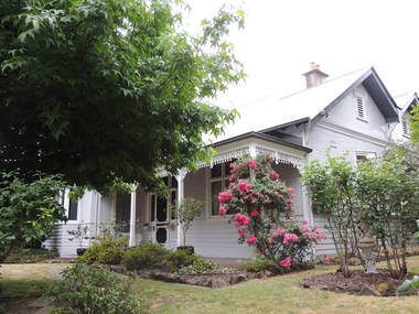
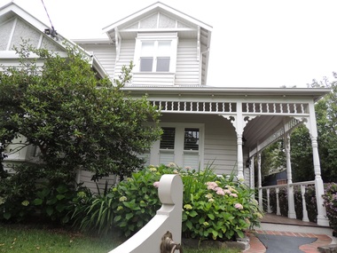
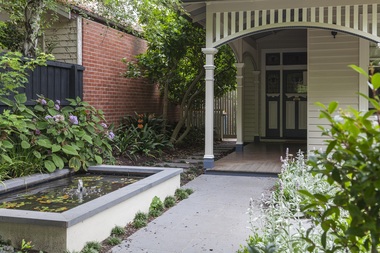
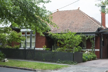
Photograph - 203 Mont Albert Road, Surrey Hills, On The Street Where You Live Project
Photos documenting this address as part of a photographic series undertaken by volunteer photographers during 2013 and 2014 for The Street Where You Live Project. This was organised through the Surrey Hills Neighbourhood Centre and covered the postcode 3127 in the cities of Boroondara and Whitehorse.These photos provide a snapshot of real estate in the suburbs of Mont Albert and Surrey Hills during a period of rapid change with many properties on large blocks demolished to create higher density residential development or renewal of single dwellings. At particular risk were properties not covered by heritage overlays, especially interwar housing and post 1950's housing. -
 Surrey Hills Historical Society Collection
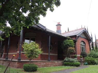
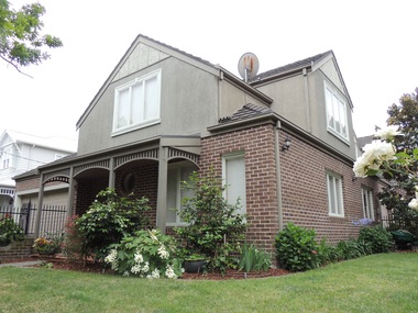
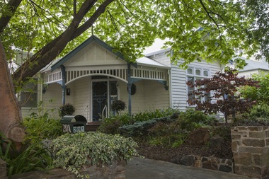
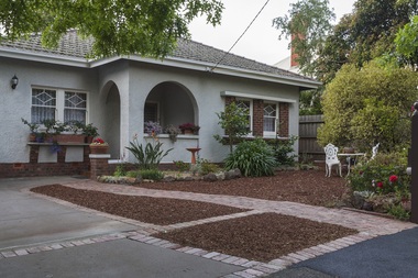
Photograph - 205 Mont Albert Road, Surrey Hills, On The Street Where You Live Project
Photos documenting this address as part of a photographic series undertaken by volunteer photographers during 2013 and 2014 for The Street Where You Live Project. This was organised through the Surrey Hills Neighbourhood Centre and covered the postcode 3127 in the cities of Boroondara and Whitehorse.These photos provide a snapshot of real estate in the suburbs of Mont Albert and Surrey Hills during a period of rapid change with many properties on large blocks demolished to create higher density residential development or renewal of single dwellings. At particular risk were properties not covered by heritage overlays, especially interwar housing and post 1950's housing. -
 Surrey Hills Historical Society Collection
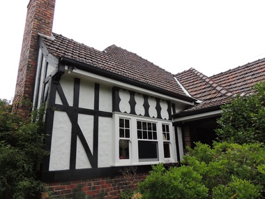
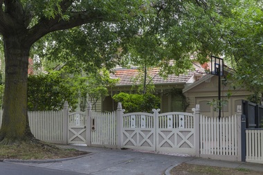
Photograph - 207 Mont Albert Road, Surrey Hills, On The Street Where You Live Project
Photos documenting this address as part of a photographic series undertaken by volunteer photographers during 2013 and 2014 for The Street Where You Live Project. This was organised through the Surrey Hills Neighbourhood Centre and covered the postcode 3127 in the cities of Boroondara and Whitehorse.These photos provide a snapshot of real estate in the suburbs of Mont Albert and Surrey Hills during a period of rapid change with many properties on large blocks demolished to create higher density residential development or renewal of single dwellings. At particular risk were properties not covered by heritage overlays, especially interwar housing and post 1950's housing. -
 Surrey Hills Historical Society Collection
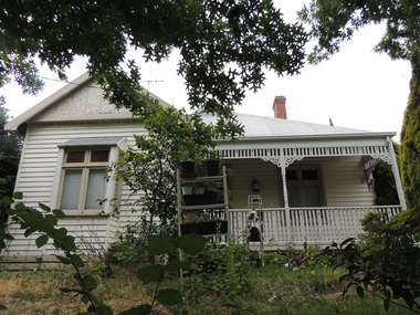
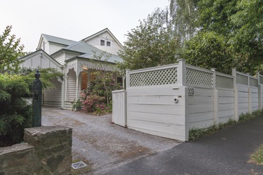
Photograph - 209 Mont Albert Road, Surrey Hills, On The Street Where You Live Project
Photos documenting this address as part of a photographic series undertaken by volunteer photographers during 2013 and 2014 for The Street Where You Live Project. This was organised through the Surrey Hills Neighbourhood Centre and covered the postcode 3127 in the cities of Boroondara and Whitehorse.These photos provide a snapshot of real estate in the suburbs of Mont Albert and Surrey Hills during a period of rapid change with many properties on large blocks demolished to create higher density residential development or renewal of single dwellings. At particular risk were properties not covered by heritage overlays, especially interwar housing and post 1950's housing. -
 Surrey Hills Historical Society Collection
Photograph - 211 Mont Albert Road, Surrey Hills, On The Street Where You Live Project
Photos documenting this address as part of a photographic series undertaken by volunteer photographers during 2013 and 2014 for The Street Where You Live Project. This was organised through the Surrey Hills Neighbourhood Centre and covered the postcode 3127 in the cities of Boroondara and Whitehorse.These photos provide a snapshot of real estate in the suburbs of Mont Albert and Surrey Hills during a period of rapid change with many properties on large blocks demolished to create higher density residential development or renewal of single dwellings. At particular risk were properties not covered by heritage overlays, especially interwar housing and post 1950's housing. -
 Surrey Hills Historical Society Collection
Photograph - 213 Mont Albert Road, Surrey Hills, On The Street Where You Live Project
Photos documenting this address as part of a photographic series undertaken by volunteer photographers during 2013 and 2014 for The Street Where You Live Project. This was organised through the Surrey Hills Neighbourhood Centre and covered the postcode 3127 in the cities of Boroondara and Whitehorse.These photos provide a snapshot of real estate in the suburbs of Mont Albert and Surrey Hills during a period of rapid change with many properties on large blocks demolished to create higher density residential development or renewal of single dwellings. At particular risk were properties not covered by heritage overlays, especially interwar housing and post 1950's housing. -
 Surrey Hills Historical Society Collection
Photograph - 215 Mont Albert Road, Surrey Hills, On The Street Where You Live Project
Photos documenting this address as part of a photographic series undertaken by volunteer photographers during 2013 and 2014 for The Street Where You Live Project. This was organised through the Surrey Hills Neighbourhood Centre and covered the postcode 3127 in the cities of Boroondara and Whitehorse.These photos provide a snapshot of real estate in the suburbs of Mont Albert and Surrey Hills during a period of rapid change with many properties on large blocks demolished to create higher density residential development or renewal of single dwellings. At particular risk were properties not covered by heritage overlays, especially interwar housing and post 1950's housing. -
 Surrey Hills Historical Society Collection
Photograph - 219 Mont Albert Road, Surrey Hills, On The Street Where You Live Project
Photos documenting this address as part of a photographic series undertaken by volunteer photographers during 2013 and 2014 for The Street Where You Live Project. This was organised through the Surrey Hills Neighbourhood Centre and covered the postcode 3127 in the cities of Boroondara and Whitehorse.These photos provide a snapshot of real estate in the suburbs of Mont Albert and Surrey Hills during a period of rapid change with many properties on large blocks demolished to create higher density residential development or renewal of single dwellings. At particular risk were properties not covered by heritage overlays, especially interwar housing and post 1950's housing. -
 Surrey Hills Historical Society Collection
Photograph - 221 Mont Albert Road, Surrey Hills, On The Street Where You Live Project
Photos documenting this address as part of a photographic series undertaken by volunteer photographers during 2013 and 2014 for The Street Where You Live Project. This was organised through the Surrey Hills Neighbourhood Centre and covered the postcode 3127 in the cities of Boroondara and Whitehorse.These photos provide a snapshot of real estate in the suburbs of Mont Albert and Surrey Hills during a period of rapid change with many properties on large blocks demolished to create higher density residential development or renewal of single dwellings. At particular risk were properties not covered by heritage overlays, especially interwar housing and post 1950's housing. -
 Surrey Hills Historical Society Collection
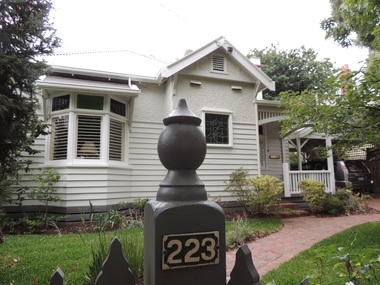
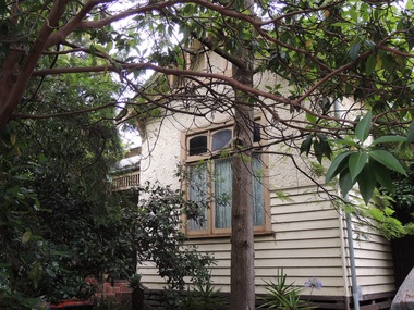
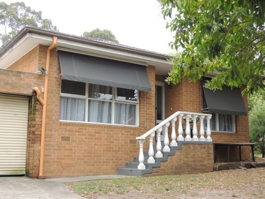
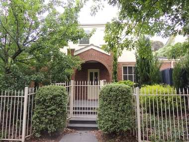
Photograph - 223 Mont Albert Road, Surrey Hills, On The Street Where You Live Project
Photos documenting this address as part of a photographic series undertaken by volunteer photographers during 2013 and 2014 for The Street Where You Live Project. This was organised through the Surrey Hills Neighbourhood Centre and covered the postcode 3127 in the cities of Boroondara and Whitehorse.These photos provide a snapshot of real estate in the suburbs of Mont Albert and Surrey Hills during a period of rapid change with many properties on large blocks demolished to create higher density residential development or renewal of single dwellings. At particular risk were properties not covered by heritage overlays, especially interwar housing and post 1950's housing. -
 Surrey Hills Historical Society Collection
Photograph - 225 Mont Albert Road, Surrey Hills, On The Street Where You Live Project
Photos documenting this address as part of a photographic series undertaken by volunteer photographers during 2013 and 2014 for The Street Where You Live Project. This was organised through the Surrey Hills Neighbourhood Centre and covered the postcode 3127 in the cities of Boroondara and Whitehorse.These photos provide a snapshot of real estate in the suburbs of Mont Albert and Surrey Hills during a period of rapid change with many properties on large blocks demolished to create higher density residential development or renewal of single dwellings. At particular risk were properties not covered by heritage overlays, especially interwar housing and post 1950's housing. -
 Surrey Hills Historical Society Collection
Photograph - 227 Mont Albert Road, Surrey Hills, On The Street Where You Live Project
Photos documenting this address as part of a photographic series undertaken by volunteer photographers during 2013 and 2014 for The Street Where You Live Project. This was organised through the Surrey Hills Neighbourhood Centre and covered the postcode 3127 in the cities of Boroondara and Whitehorse.These photos provide a snapshot of real estate in the suburbs of Mont Albert and Surrey Hills during a period of rapid change with many properties on large blocks demolished to create higher density residential development or renewal of single dwellings. At particular risk were properties not covered by heritage overlays, especially interwar housing and post 1950's housing. -
 Surrey Hills Historical Society Collection
Photograph - 229 Mont Albert Road, Surrey Hills, On The Street Where You Live Project
Photos documenting this address as part of a photographic series undertaken by volunteer photographers during 2013 and 2014 for The Street Where You Live Project. This was organised through the Surrey Hills Neighbourhood Centre and covered the postcode 3127 in the cities of Boroondara and Whitehorse.These photos provide a snapshot of real estate in the suburbs of Mont Albert and Surrey Hills during a period of rapid change with many properties on large blocks demolished to create higher density residential development or renewal of single dwellings. At particular risk were properties not covered by heritage overlays, especially interwar housing and post 1950's housing. -
 Surrey Hills Historical Society Collection
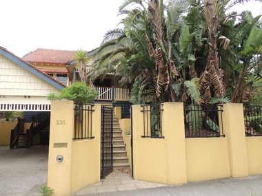
Photograph - 231 Mont Albert Road, Surrey Hills, On The Street Where You Live Project
Photos documenting this address as part of a photographic series undertaken by volunteer photographers during 2013 and 2014 for The Street Where You Live Project. This was organised through the Surrey Hills Neighbourhood Centre and covered the postcode 3127 in the cities of Boroondara and Whitehorse.These photos provide a snapshot of real estate in the suburbs of Mont Albert and Surrey Hills during a period of rapid change with many properties on large blocks demolished to create higher density residential development or renewal of single dwellings. At particular risk were properties not covered by heritage overlays, especially interwar housing and post 1950's housing. -
 Surrey Hills Historical Society Collection
Photograph - 233 Mont Albert Road, Surrey Hills, On The Street Where You Live Project
Photos documenting this address as part of a photographic series undertaken by volunteer photographers during 2013 and 2014 for The Street Where You Live Project. This was organised through the Surrey Hills Neighbourhood Centre and covered the postcode 3127 in the cities of Boroondara and Whitehorse.These photos provide a snapshot of real estate in the suburbs of Mont Albert and Surrey Hills during a period of rapid change with many properties on large blocks demolished to create higher density residential development or renewal of single dwellings. At particular risk were properties not covered by heritage overlays, especially interwar housing and post 1950's housing. -
 Surrey Hills Historical Society Collection
Photograph - 235 Mont Albert Road, Surrey Hills, On The Street Where You Live Project
Photos documenting this address as part of a photographic series undertaken by volunteer photographers during 2013 and 2014 for The Street Where You Live Project. This was organised through the Surrey Hills Neighbourhood Centre and covered the postcode 3127 in the cities of Boroondara and Whitehorse.These photos provide a snapshot of real estate in the suburbs of Mont Albert and Surrey Hills during a period of rapid change with many properties on large blocks demolished to create higher density residential development or renewal of single dwellings. At particular risk were properties not covered by heritage overlays, especially interwar housing and post 1950's housing. -
 Surrey Hills Historical Society Collection
Photograph - 237 Mont Albert Road, Surrey Hills, On The Street Where You Live Project
Photos documenting this address as part of a photographic series undertaken by volunteer photographers during 2013 and 2014 for The Street Where You Live Project. This was organised through the Surrey Hills Neighbourhood Centre and covered the postcode 3127 in the cities of Boroondara and Whitehorse.These photos provide a snapshot of real estate in the suburbs of Mont Albert and Surrey Hills during a period of rapid change with many properties on large blocks demolished to create higher density residential development or renewal of single dwellings. At particular risk were properties not covered by heritage overlays, especially interwar housing and post 1950's housing. -
 Surrey Hills Historical Society Collection
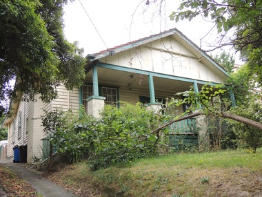
Photograph - 200 Prospect Hill Road, Surrey Hills, On The Street Where You Live Project
Photos documenting this address as part of a photographic series undertaken by volunteer photographers during 2013 and 2014 for The Street Where You Live Project. This was organised through the Surrey Hills Neighbourhood Centre and covered the postcode 3127 in the cities of Boroondara and Whitehorse.These photos provide a snapshot of real estate in the suburbs of Mont Albert and Surrey Hills during a period of rapid change with many properties on large blocks demolished to create higher density residential development or renewal of single dwellings. At particular risk were properties not covered by heritage overlays, especially interwar housing and post 1950's housing. -
 Surrey Hills Historical Society Collection
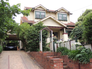
Photograph - 201 Prospect Hill Road, Surrey Hills, On The Street Where You Live Project
Photos documenting this address as part of a photographic series undertaken by volunteer photographers during 2013 and 2014 for The Street Where You Live Project. This was organised through the Surrey Hills Neighbourhood Centre and covered the postcode 3127 in the cities of Boroondara and Whitehorse.These photos provide a snapshot of real estate in the suburbs of Mont Albert and Surrey Hills during a period of rapid change with many properties on large blocks demolished to create higher density residential development or renewal of single dwellings. At particular risk were properties not covered by heritage overlays, especially interwar housing and post 1950's housing. -
 Surrey Hills Historical Society Collection
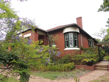
Photograph - 202 Prospect Hill Road, Surrey Hills, On The Street Where You Live Project
Photos documenting this address as part of a photographic series undertaken by volunteer photographers during 2013 and 2014 for The Street Where You Live Project. This was organised through the Surrey Hills Neighbourhood Centre and covered the postcode 3127 in the cities of Boroondara and Whitehorse.These photos provide a snapshot of real estate in the suburbs of Mont Albert and Surrey Hills during a period of rapid change with many properties on large blocks demolished to create higher density residential development or renewal of single dwellings. At particular risk were properties not covered by heritage overlays, especially interwar housing and post 1950's housing. -
 Surrey Hills Historical Society Collection
Photograph - 203 Prospect Hill Road, Surrey Hills, On The Street Where You Live Project
Photos documenting this address as part of a photographic series undertaken by volunteer photographers during 2013 and 2014 for The Street Where You Live Project. This was organised through the Surrey Hills Neighbourhood Centre and covered the postcode 3127 in the cities of Boroondara and Whitehorse.These photos provide a snapshot of real estate in the suburbs of Mont Albert and Surrey Hills during a period of rapid change with many properties on large blocks demolished to create higher density residential development or renewal of single dwellings. At particular risk were properties not covered by heritage overlays, especially interwar housing and post 1950's housing. -
 Surrey Hills Historical Society Collection
Photograph - 204 Prospect Hill Road, Surrey Hills, On The Street Where You Live Project
Photos documenting this address as part of a photographic series undertaken by volunteer photographers during 2013 and 2014 for The Street Where You Live Project. This was organised through the Surrey Hills Neighbourhood Centre and covered the postcode 3127 in the cities of Boroondara and Whitehorse.These photos provide a snapshot of real estate in the suburbs of Mont Albert and Surrey Hills during a period of rapid change with many properties on large blocks demolished to create higher density residential development or renewal of single dwellings. At particular risk were properties not covered by heritage overlays, especially interwar housing and post 1950's housing. -
 Surrey Hills Historical Society Collection
Photograph - 205 Prospect Hill Road, Surrey Hills, On The Street Where You Live Project
Photos documenting this address as part of a photographic series undertaken by volunteer photographers during 2013 and 2014 for The Street Where You Live Project. This was organised through the Surrey Hills Neighbourhood Centre and covered the postcode 3127 in the cities of Boroondara and Whitehorse.These photos provide a snapshot of real estate in the suburbs of Mont Albert and Surrey Hills during a period of rapid change with many properties on large blocks demolished to create higher density residential development or renewal of single dwellings. At particular risk were properties not covered by heritage overlays, especially interwar housing and post 1950's housing. -
 Clunes Museum
Certificate, 3/11/1941
Certificate in appreciation of voluntarily enlisting in WW2Heavy paper, white background, City of Melbourne Heraldic Shield, Aust Comm Military Forces Insignia at bottomPresented to J. D. Brusaschi by the Lord Mayor, Councillors, and citizens of the City of Melbourne as a record and in appreciation of his patriotic response to the call of Empire by Voluntarily Enlisting for active serviceww2 memorabilia, city of melbourne, enlistment -
 Beechworth Honey Archive
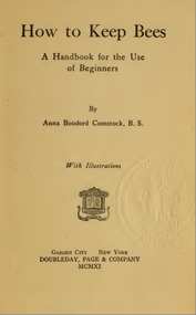
Publication, e-book, How to keep bees: a handbook for the use of beginners (Comstock, A. B.), Garden City, 1911, 1911
-
 Williamstown Botanic Gardens- Hobsons Bay City Council
Photographs - Williamstown Botanic Gardens, 1936
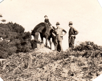
Ernest Anderson (head gardener) and Harry (gardener) worked at Williamstown Botanic Gardens. The Anderson family lived in the curators lodge on the grounds in the 1930s. Horses were used at the gardens until the 1960s when the council bought a truck. Mr Biggs drove as Mr Anderson did not have a licence. He rode his bike to the Town Hall every Friday to put in the time sheets. The collection is the only known photos of the Gardens working horses and demonstrates Edwardian Municipal gardening techniques that continued into the 1960s. They are photographic evidence of the planting styles, species choices and structures. Details inscribed on the reverse of some of the photos confirm names of staff at this time. Photo 13 (m) m: Only known photo of Ernest Anderson to be held by the Gardens2013.001.a-l is a collection of 12 small format photographs from the Anderson family album dated from 1917-1936 plus one large image of donor's wedding c1953. Ernest Anderson (head gardener) and Harry (gardener) worked at Williamstown Botanic Gardens. The Anderson family lived in the curators lodge on the grounds in the 1930s. Photo 1 (a) Sepia photo of young girl (Chic Anderson) on horse with no saddle. Two men, with hands on hips, standing alongside wearing hats. All are on a small hill (a compost heap) with a shrub on the left of the image. Photo 2 (b) Young girl and horse standing on the top of a small hill (compost heap). Girl has short hair and is wearing a jumper, skirt and long socks. Horse has no saddle and has its head down as if to eat. Photo 3 (c) Horse and foal standing in a fenced enclosure. Part of yard is paved. Horse has a white blaze and white feet. Foal has white blaze and white legs and is looking up at the horse. Photo 4 (d) Horse pulling a mower. Two men standing with mower. One is holding mower, the other the reins of the horse. Both men are wearing hats, with one wearing a vest. Horse has hessian wrapping on his hooves. Photo 5 (e) Horse and man. Horse has a rope bridle. Man holding bridle and is dressed in trousers, shirt, cardigan and hat. They are in front of a hedge and closed timber gate. Tall palm is in background. Horse is side on to the camera. Photo 6 (f) Man and horse standing in front of hedge and open timber gate. Palms in background. Man wearing trousers, shirt, vest, tie, hat. Trousers look to be tucked into boots. He is looking at the horse. The horse is facing the camera. Photo 7 (g) Three horses looking over a picket fence. All with a white blaze. There is a timber wall with a window to the right of the photograph. A man’s arm holding something is seen on the right of the photo. Photo 8 (h) Large palm tree, understorey of shrubs with two palms in the background. Photo 9 (i) Scene of the Gardens. Path dividing at a conifer tree. Woman in long skirt and hat looking up at the conifer. Different varieties of palm trees with understorey of shrubs. Photo 10 (j) Garden bed of Dahlias surrounded by a wire fence. Palms and other trees in background. Photo 11 (k) Avenue of tall palm trees with under storey of shrubs. Photo has angles cut at top corners and two large crease marks at the bottom right hand corner. Photo 12 (l) Set of cast iron gates – double carriage gates with single pedestrian gates on either side and supported by four cast iron posts with ornamental finials on top. Photo 13 (m) Ernest Anderson and daughter Chic prior to her wedding. Ernest is holding his gloves in his left hand and Chic’s hand with his right. Palms trees in the background. Photo 1 (a) 'Ern & Harry / May 8th 1936' Photo 2 (b) ‘Jack aged 36 / Chic 5 years / (unclear) 1936’ Photo 3 (c) ‘foal born in / back shed’ Photo 4 (d) ‘The Olde Firm / Jack Ernie Harry / 1917’ Photo 6 (f ) ‘Before the / council provided / a truck all / work was done / with the horses’ Photo 7 (g) ‘our work horses’ Photo 9 (i) ‘Panoramic view of Gardens / looking South from Lodge / Wms Town Botanical Gardens / 15-10-17’ Photo 12 (l) ‘Gates Public Gardens’hobsons-bay-city-council, curator, lodge, horse, transport, dahlia, compost, anderson, williamstown, botanic, gardens, williamstown-botanic-gardens, hobsons-bay, hobsons, edwardian, gardening, 1936, 1917, -
 Williamstown Botanic Gardens- Hobsons Bay City Council
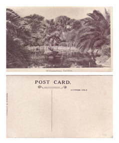
Postcard - Williamstown Botanic Gardens, 1900-1920
The original postcards in this series (2013.002 to 2013.018) were generously loaned to Williamstown Botanic Gardens by a private collector for copyingThey are evidence of the interest the gardens held as a subject for postcard publishers. The text and images provide a snapshot into fashions, social interests and concerns of the time. The professionally produced images provide a pictorial history of Gardens including changing planting styles, various structures and features of the Gardens eg the aviary, cannons, the fountain, the second Curator’s Lodge and gates. The images offer an opportunity to compare garden vistas with the present day. This postcard shows the ornamental lake, completed 1904, with its surrounding Guilfoyle influenced rockery, planted with original succulents and palms Black and white postcard titled “Williamston Gardens”. Ornamental lake surrounded by palms, with trees in the background and boarded with stone slabs. There is a small island in the middle of the image surrounded by water lilies. Inscribed on the reverse: ‘POST CARD.’ centre top underlined by two wriggly lines, the bottom one is scrolled at either end / ADRESS ONLY’ top right side of card / ‘PRODUCED IN AUSTRALIA’ vertically on left side of cardpostcard, pond, palms, post-card, williamstown-botanic-gardens, hobsons-bay-city-council, water lilies, pond-island -
 Williamstown Botanic Gardens- Hobsons Bay City Council
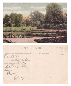
Postcard - Williamstown Botanic Gardens
The original postcards in this series (2013.002 to 2013.018) were generously loaned to Williamstown Botanic Gardens by a private collector for copying. They are evidence of the interest the gardens held as a subject for postcard publishers. The text and images provide a snapshot into fashions, social interests and concerns of the time. The professionally produced images provide a pictorial history of Gardens including changing planting styles, various structures and features of the Gardens eg the aviary, cannons, the fountain, the second Curator’s Lodge and gates. The images offer an opportunity to compare garden vistas with the present day.Colour postcard of garden beds with man (gardener) standing beside tree with a sign on it on right side of card. The card was sent to Nellie from Gladys for birthday greetingsFront: ‘Botanic Gardens, Williamstown’. Reverse: ‘POST CARD’ centre top of card, underlined with a dividing line down the centre of the card. ‘This Space may be used for Correspondence.’ on left side of line; ‘For Address Only.’ and ‘165/103598’ on right side of line. In pencil on top right corner ‘1906 SLV’. On left side in cursive writing ‘To Nellie / wishing her / many happy / returns of the / day. / From / Gladyspostcard, garden-beds, gardener, post-card, williamstown-botanic-gardens, hobsons-bay-city-council, 1906, nellie, gladys, colour-postcard -
 Williamstown Botanic Gardens- Hobsons Bay City Council
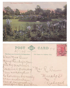
Postcard - Williamstown Botanic Gardens, Prior to 1909
The original postcards in this series (2013.002 to 2013.018) were generously loaned to Williamstown Botanic Gardens by a private collector for copying. The postcards are evidence of the interest the gardens held as a subject for postcard publishers. The text and images provide a snapshot into fashions, social interests and concerns of the time. The professionally produced images provide a pictorial history of Gardens including changing planting styles, various structures and features of the Gardens eg the aviary, cannons, the fountain, the second Curator’s Lodge and gates. The images offer an opportunity to compare garden vistas with the present day. The many annuals seen in this postcard demonstrates the intensity of Edwardian gardening Colour Postcard of staked flowers (mostly blue) surrounding a grassed area with a circular garden in the centre and trees in the backgroundFront: ‘The Botanic Gardens, Williamstown’. Reverse: ‘POST W.T.P. (in a double rectangle inside a patterned diamond) CARD’ centre top of card, underlined with a dividing line down the centre of the card. ‘This Space may be used for Correspondence’ on left side of line; ‘This Space for Address Only.’ on right side of line. A red Victorian one penny stamp on right top corner. In pencil under ‘POST’: ‘21/1/09’. See image for inscription from Julia to Miss R Gunn.postcard, garden-beds, post-card, williamstown-botanic-gardens, hobsons-bay-city-council, 1909, miss gunn, colour-postcard, flowers, julia -
 Williamstown Botanic Gardens- Hobsons Bay City Council
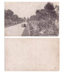
Postcard - Williamstown Botanic Gardens, 1900-1920
The original postcards in this series (2013.002 to 2013.018) were generously loaned to Williamstown Botanic Gardens by a private collector for copying. The postcards are evidence of the interest the gardens held as a subject for postcard publishers. The text and images provide a snapshot into fashions, social interests and concerns of the time. The professionally produced images provide a pictorial history of Gardens including changing planting styles, various structures and features of the Gardens eg the aviary, cannons, the fountain, the second Curator’s Lodge and gates. The images offer an opportunity to compare garden vistas with the present day. This postcard shows the main east-west axial path with a typical Victorian/Edwardian mown grass strip which in turn borders formal shrub beds with herbaceous plantings. The Cordylines which line and avenue in this image were replaced by Mexican Fan Palms (Washingtonia robusta) planted in 1915. They were replaced with the same species in 1987. Black and white postcard of Gardens main path, looking towards a white statue on a plinth. The statue is of Williamstown MLA, A T Clark. There are for people walking towards the camera – two women, a small girl and two men. The women and child are on the right of the path and the men on the left. One woman is pushing a pram. The path is edged with grass and the beds are full of flowers. There are no palms lining the path as there are today in 2013. On front of postcard ‘IN THE GARDENS, WILLIAMSTOWN’.postcard, garden-beds, post-card, williamstown-botanic-gardens, hobsons-bay-city-council, pram, clark