Showing 124165 items
matching main-road
-
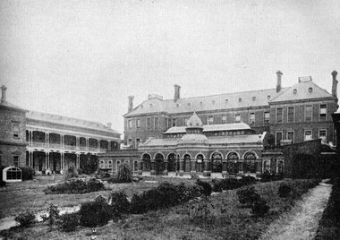 St Patrick's Old Collegians Association (SPOCA)
Photograph - Buildings, Xavier College, 1898
-
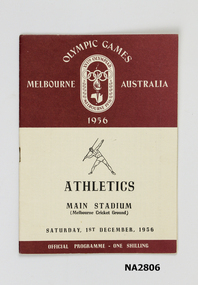 Whitehorse Historical Society Inc.
Memorabilia - Olympic Games Programme
Programme for Athletics in the Main Stadium, Saturday 1 December 1956. Melbourne Olympics.Olympic Games, Melbourne, Australia, 1956.|XVI th Olympiad, Melbourne, 1956.documents, programmes -
 Lakes Entrance Historical Society
Postcard - Bairnsdale District Hospital, H D Bulmer, 1910 c
Sepia toned postcard of the main entrance and gateway of the District Hospital at Bairnsdale VictoriaBAIRNSDALE DISTRICT HOSPITALhospital -
 Lakes Entrance Historical Society
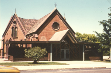
Photograph - St Andrews Presbyterian Church Bairnsdale Victoria, Ian Fraser, 1980 c
Sold for business use after amalgamation of Presbyterian and Methodist cjurches to become Uniting ChurchColour photograph of St Andrews Presbyterian Church Main Street Bairnsdale Victoriahistoric buildings, religion, churches -
 Whitehorse Historical Society Inc.
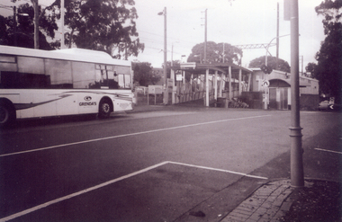
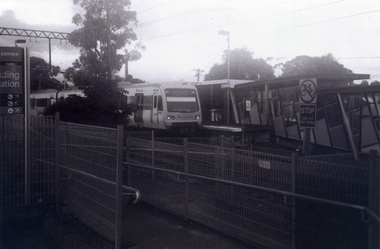
Photograph, Nunawading Railway Station, 1/06/2009
One of a collection of photographs taken of the Nunawading Railway Station prior to the lowering of the railway line and building of the new railway station on the western side of Springvale Road so that the Springvale Road Rail Crossing can be eliminated.Black & white photograph of he precinct surrounding the Nunawading Station and the Springvale Road Railway crossing. This photograph is of the southern entrance from Station Street. Note the Grenda Bus|See NP 3545 to NP3567for the complete set of photographsnunawading railway station, springvale road nunawading, redevelopment of railway line/springvale road., station street nunawading -
 Whitehorse Historical Society Inc.
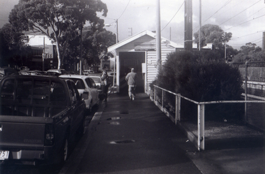
Photograph, Looking across crossing towards liquor store, 1/06/2009
One of a collection of photographs taken of the Nunawading Railway Station prior to the lowering of the railway line and building of the new railway station on the western side of Springvale Road so that the Springvale Road Rail Crossing can be eliminated.Black & white photograph of he precinct surrounding the Nunawading Station and the Springvale Road Railway crossing. This photograph is the view looking across railway crossing towards liquor store. See NP 3545 to NP3567 for the complete set of photographsnunawading railway station, springvale road nunawading, redevelopment of railway line/springvale road. -
 Whitehorse Historical Society Inc.
Photograph, Nunawading Station looking from the north side, 1/06/2009
One of a collection of photographs taken of the Nunawading Railway Station prior to the lowering of the railway line and building of the new railway station on the western side of Springvale Road so that the Springvale Road Rail Crossing can be eliminated.Black & white photograph of he precinct surrounding the Nunawading Station and the Springvale Road Railway crossing. This photograph is the station looking from the entrance of station on the north side of the tracks. See NP 3545 to NP3567 for the complete set of photographsnunawading railway station, springvale road nunawading, redevelopment of railway line/springvale road. -
 Whitehorse Historical Society Inc.
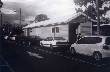
Photograph, Looking to Booking Office on North side of Nunawading Station, 1/06/2009
One of a collection of photographs taken of the Nunawading Railway Station prior to the lowering of the railway line and building of the new railway station on the western side of Springvale Road so that the Springvale Road Rail Crossing can be eliminated.Black & white photograph of he precinct surrounding the Nunawading Station and the Springvale Road Railway crossing. This photograph is the entrance to the Booking Office for trains from Nunawading travelling east. See NP 3545 to NP3567 for the complete set of photographsnunawading railway station, springvale road nunawading, redevelopment of railway line/springvale road. -
 Whitehorse Historical Society Inc.
Photograph, Nunawading Station - North Side, 1/06/2009
One of a collection of photographs taken of the Nunawading Railway Station prior to the lowering of the railway line and building of the new railway station on the western side of Springvale Road so that the Springvale Road Rail Crossing can be eliminated.Black & white photograph of he precinct surrounding the Nunawading Station and the Springvale Road Railway crossing. This photograph is of the Booking Office and Waiting Rooms on the North side of the Nunawading Station . See NP 3545 to NP3567 for the complete set of photographsnunawading railway station, springvale road nunawading, redevelopment of railway line/springvale road. -
 Kew Historical Society Inc
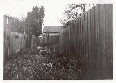
Photograph - Right-of-way at rear of Parkhill Road and Lalla Street, 1973
One of a series of photographs donated by the City Engineer of the former City of Kew, relating to road works. The photos variably include council workers, signage and equipment.One of a series of photographs of core local government services as practised by the City of Kew. The photographs are an accurate record of street works of the period.Original black and white photographic positive of a right-of-way at the rear of houses in Parkhill Road and Lalla street, Kew. The right-of-way is overgrown preventing access or egress."ROW AT REAR OF PROPERTIES / PARKHILL RD / LALLA ST / JULY '73"city of kew, local government -- city of kew, right-of-ways -- kew (vic.), lanes -- kew (vic.), parkhill road, lalla street, council works -
 Eltham District Historical Society Inc
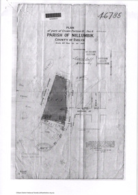
Document - Photocopy, Survey Fleld Notes of Part of Crown Portion 13, Section 4 at Eltham, Parish of Nillumbik, County of Evelyn, 7 May 1925
Portion of land bounded by: Main Road, Eltham Railway Station Application 46785 J.T. Robinson, Surveyor, 7 May 1925application 46785, arthur street, bible street, eltham, eltham railway station, luck street, main road, map, survey plan -
 Eltham District Historical Society Inc
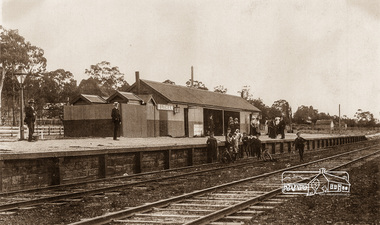
Photograph, Eltham Railway Station, c.1910, 1910c
Intending passengers were able to walk down from Main Road and straight onto the railway platform; there was no rail track on that side then.Copy of sepia photographeltham railway station -
 Greensborough Historical Society
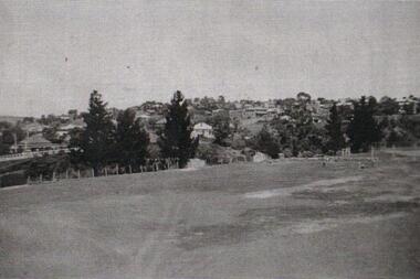
Photograph - Digital image, View from Greensborough Lower Oval, 1935c
Photograph of the Greensborough Lower Oval in Main Street Greensborough opposite St Helena Road. The village of Greensborough can be seen In the background.An early view of Greensborough.Digital copy of black and white photograph.greensborough, lower oval greensborough -
 Eltham District Historical Society Inc
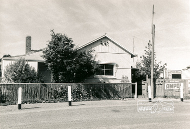
Photograph, Panton Hill Post Office, 27 Apr. 1968
Former Panton Hill Post Office, Main Road, Panton Hil with Panton Hill Rural Fire Brigade next doorBlack and white photographpanton hill, post office, ampol service station, panton hill rural fire brigade, rural fire brigade, service station -
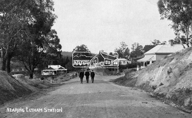 Eltham District Historical Society Inc
Negative - Photograph, Nearing Eltham Station, c.1904
Eltham, Main Road, looking north from Bridge Street. Gahan house on left. Bakery on right at corner of York Street.This photo forms part of a collection of photographs gathered by the Shire of Eltham for their centenary project book,"Pioneers and Painters: 100 years of the Shire of Eltham" by Alan Marshall (1971). The collection of over 500 images is held in partnership between Eltham District Historical Society and Yarra Plenty Regional Library (Eltham Library) and is now formally known as the 'The Shire of Eltham Pioneers Photograph Collection.' It is significant in being the first community sourced collection representing the places and people of the Shire's first one hundred years.Digital image 4 x 5 inch B&W Negsepp, shire of eltham pioneers photograph collection, eltham, main road, gahan house, gahan, york street -
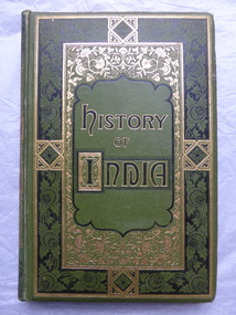 Warrnambool and District Historical Society Inc.
Books, History of India, 1870s and 1880s
These books appear to have been published in successive years as the inscription on one is 1875 and the contents of another deals with the history of India in 1878. The owner of the volumes was William Cassady (1824-1885).In 1846 he settled near the Merri River in the district that is today the Cassady's Bridge area in Caramut Road, Warrnambool. The property was called "Boughton". He married Elizabeth Anderson in 1857 and they had eleven children surviving to adulthood.These volumes are of antiquarian interest as they are an attractive example of the type of books owned by early settlers in the Warrnambool district. The activities of the British in India would have been of interest to settlers in other parts of the British Empire at that time. The books are also of interest as they belonged to William Cassady, a prominent early settler in the west Warrnambool area.These are five volumes of hard cover books with green covers and elaborate scrolls and decorations on the front covers and spines. The title lettering on the front covers is in black and gold. Each volume has several pages of black and white illustrations (steel engravings)at the front of the books, all with protective tissue paper. Some of the tissue paper is torn or missing. There are several coloured maps. The pages are gilt- edged.The third volume has the top part of the spine and binding torn away. The inscription in Volume Four is written in black ink.William Cassady, Boughton 1875william and elizabeth cassady -
Glen Eira Historical Society
Article - St. Agnes Church, Booran Road, 116, Glen Huntly
Two examples of marriages celebrated at St. Agnes: Marriage service of Cecelia Soriano-Mateos and Gregogry Walsh at St. Agnes Anglican Church, Booran Road Glen Huntly dated 08/01/1995 – service booklet. Newspaper article from Sunday Herald Sun, dated 11/09/2011 of St. Agnes couple Bob and Joy Parnell’s 60th wedding anniversary of 08/09/2011.mateos-soriano cecelia, walsh gregory, st. agnes church, booran road, glen huntly, glenhuntly, ross joy, parnell bob, parnell demis, parnell bruce, parnell joy, youth groups, weddings -
Glen Eira Historical Society
Document - Helenslea, Shelford CEGGS
Three copies of a photocopied fold out brochure relating to the auction of 48 lots in the Helenslea Estate on 25/03/1916. The brochure references St Mary’s Church, shops on Glen Eira Road, Caulfield Grammar School, and existing homes in the vicinity and includes photographs of these localities. Reference is also made to available public transport and trees on the Estate. The brochure also includes an illustrated bird’s eye map of the Estate.helenslea estate, glen eira road, st kilda east, mansions, orrong road, balaclava road, caulfield grammar school, fosberry avenue, st mary’s church, land subdivision, land brochures, residential development, auctions, caulfield north -
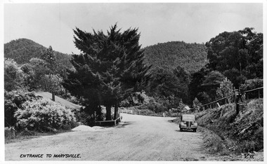 Marysville & District Historical Society
Postcard (item) - Black and white postcard, Valentine Publishing Co. Pty. Ltd, Entrance to Marysville V.11, 1923-1963
A digital copy of an early black and white photograph of the Marysville-Wood's Point Road at the corner with Murchison Street in Marysville in Victoria.A digital copy of an early black and white photograph of the Marysville-Wood's Point Road at the corner with Murchison Street in Marysville in Victoria. This postcard was published by the Valentine Publishing Co. Pty. Ltd. as a souvenir of Marysville.marysville, victoria, postcard, valentine publishing co, souvenir, murchison street, marysville-wood's point road -
 Eltham District Historical Society Inc
Photograph, Cr. Peter Graham, Eltham Library construction, Oct. 1993
Central roof dome as seen from Main Road, Roof structures being fitted over the main hall, Eltham Library construction, Oct 1993 Construction of the new Eltham Library 1993-1994. Officially opened 22 May 1994. Colour photograph print on Agfa photographic paper 10 x 15 cmconstruction, eltham library -
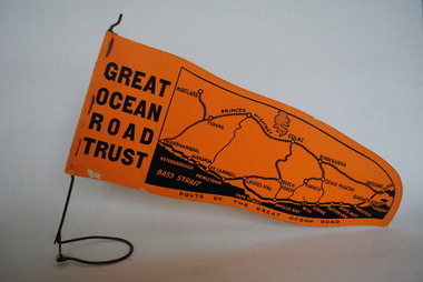 Anglesea and District Historical Society
Pennant, Unknown
Orange pennant flag listing towns on and near the Great Ocean Road. List of town names on pennant - (west to east) Mortlake, Warrnambool, Nirranda, Terang, Port Campbell, Lavers Hill, Colac, Beech Forest, Apollo Bay, Wye, Birregurra, Forrest, Deans Marsh, Peterborough, Princetown, Lorne, Eastern View, Airy's Inlet, Anglesea, Torquay, Geelong, Barwon Heads.GREAT/ OCEAN/ ROAD/ TRUST. Map of Area/ Route of the Great Ocean. (Orange - on wire stand. Printed on both sides.) great ocean road trust -
Canterbury History Group
Pamphlet - Mont Albert Park, Camberwell
Copy of the pamphlet for subdivision of Mont Albert Park, includes Mangarra Road, Malaca Road, Gwinda Avenue, Irilbarra Road and Canterbury Roadcanterbury, canterbury road, gwenda avenue, irilbarra road, mangarra road, malaca road, mont albert park, land subdivision -
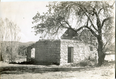 The Beechworth Burke Museum
Photograph, Approximately 1930
Taken in approximately 1930, this photograph depicts the ruins of Rosehill Dairy. A woman stands beside the ruins, observing them solemnly. The owner of this once prominent dairy, John Brewer, was born in Cornwall, England in 1832. After coming to Australia in 1849, Brewer worked in various forms of livestock transportation. Upon hearing of the vast discovery of gold in Victoria's north-east, he engaged in mining in the Ovens Goldfield district before starting his own dairy on Wooragee road (now Old Wooragee road). The Wooragee Valley, approximately five kilometres north of Beechworth, was used extensively during the nineteenth century to build farming practices in the area, possessing eighteen farms by 1860. Brewer enjoyed a prosperous career in the dairy industry, personally delivering milk to the residents of Beechworth. He died on the thirteenth of August 1915, a few weeks shy of his eighty-third birthday. As this photograph is dated approximately fifteen years later, it can be assumed that the dairy fell into neglect following his death. This photograph is historically significant as it provides insight the development of the dairy industry in Beechworth in the second half of the nineteenth century.Black and white square photograph printed on matte photographic paper Reverse: 1997.2912 / John Brewers / Rosehill / Dairy / top of the 'rising sun' /john brewer, 1930 beechworth, rosehill dairy, dairy industry beechworh, dairy factories beechworth, dairying, dairy farm beechworth, wooragee road, wooragee valley, old wooragee road, dairy farm ruins -
Glen Eira Historical Society
Document - National Council of Jewish Women
This file contains two items relating to the National Council of Jewish Women (Victorian Section): 1/An invitation to the 63rd Annual Luncheon of the National Council on 14/03/1990, at Tudor Court Receptions, 141 Kooyong Road, Caulfield. The invitation states that the guest speaker will be Annette Allison, media and television personality. Inside the invitation when unfolded, is a long list of the Council’s Patronesses and Hostesses 2/A photocopy of a newspaper article entitled ‘NCJW moves into new home’ by Eileen Vamos, date and newspaper unknown, relating to the opening of the National Council’s new Victorian Headquarters at 131-133 Hawthorn Road, Caulfield North, named the Annia Castan Centre and Sadie Fink offices. The article discusses the opening Caulfield Park, the work of Annia Castan and Sadie Fink after whom the headquarters were named, and plans for the use of the Annia Castan planting a tree as others look on, and the other of Mayor and Mayoress of Caulfield, Jack and Felicitie Campbell, at the planting ceremony.national council of jewish women, tudor court receptions, kooyong road, caulfield, solomon geulah dr., allison annette, caulfield park, hawthorn road, caulfield north, bassat nina, castan annia, fink sadie, fink mina, fink jack, shipton roger, mccutcheon andrew, cornard geoff, campbell jack mayor, capbell felicitie mayoress, shulman phillip, curan george, sokolowich aaron, balint susie, mallinek malvina, samuel ian, sheedy ray, ilan, open door project, jewish welfare society, jnf victoria, westbury street, balaclava, jewish community, open ceremony, community groups, tree planting ceremonies, official events, mayors, annie castan centre, sadie fink offices -
Port Melbourne Historical & Preservation Society
Document - Short Road Ferry ticket, c.1974
From the collection of Warren DOUBLEDAY. The short Road ferry ran between the end of Williamstown Road in Port Melbourne across the narrowest section of the Yarra River to the bottom of the Strand in Williamstown. The name came from it being the 'short road' between the two places. There was a type of ferry service in operation from around 1873 which was modernised in the 20th century to take cars and trucks across the river. It was operated by two heavy chains which sank to the river bed to allow ships to pass.A single trip 15 cent ticket for crossing the Yarra River from Williamstown on the Short Road Ferry. The off white ticket has two diagonal blue stripes and the number F 048261 printed on the side. transport - ferries, short road ferry, williamstown, transport - motor vehicles -
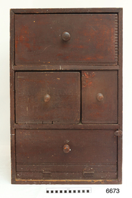 Flagstaff Hill Maritime Museum and Village
Furniture - Cupboard, c. 1890
The materials used to build the colonial cupboard have been gathered from various sources and recycled. In those days, it was normal to keep all manner of items 'just in case' they could be repurposed for another item. The brand "Laurel" on one of the wooden panels is from the Mobil Oil company's kerosene. There In the words of the donor, Betty Stone, "Made by Ellis Dale of Latrigg Wangoom, Warrnambool c 1890. The cupboard consists of packing cases stamped with original brand names. One drawer made from a gelignite packing case is of special significance as the Dale family owned a bluestone quarry known as The Dale Bluestone Quarries at Wangoom situated about three miles east of Warrnambool. Ellis Dale, second son of William Dale and Elizabeth (nee Chamberlain) Dale, was born in Wangoom, Warrnambool on 21 November 1860. His father, William Dale, a quarryman from Saddleworth, Yorkshire migrated to Australia in 1852; seven years later - in 1859- he purchased the quarries on twenty acres of land situated in Wangoom at the corner of what is now known as Dales and Aberline Roads. Later, when his two eldest sons, William Jnr and Ellis, reached ten or eleven years of age they worked with their father in the quarries. The work was arduous and dangerous as gelignite was used to blast the bluestone. In 1890 Ellis Dale married Ann Lees, daughter of Lees and Sarah (nee Chamberlain) Lees of Wangoom, Warrnambool. Initially Ellis and Ann Dale resided in a two roomed bluestone cottage which Ellis built a little further up the hill from his parents' home on the Dale family property. A few years later, in order to accommodate their growing family, additional rooms were added making a spacious, comfortable weatherboard home situated in Dales Road which they named Latrigg. Ellis Dale constructed this cupboard soon after he and Ann first set up home in their little stone cottage in 1890. When the home was rebuilt, the home-made cupboard was moved into the larger kitchen, and although Latrigg was well furnished, it remained in the corner between the kitchen door and the large wood stove where it served its purpose very well as it was used for storing ironing utensils. The lower compartment with the hinged drop-door was designed to store the flat irons which were heated on the wood stove, while the ironing blanket and cover, iron holders and other items were stored in the drawers. The Dale quarrying and contracting business existed in Wangoom, Warrnambool for over eighty years as after William Dale’s death. Ellis Dale together with his son lvor, continued on until he died in 1940. (Note: For additional information please refer to Betty Stone’s book “Pioneers and Places - A History of three Warrnambool Pioneering Families” i.e. Chamberlain, Dale and Lees Families)This item is associated with families of Chamberlain, Dale and Lees. These families are listed in the "Pioneers' Register" for Warrnambool Township and Shire, 1835-1900, published by A.I.G.S. Warrnambool Branch.Cupboard, rare example of a Colonial Cupboard, wooden. Made by Ellis Dale from packing cases; several brand names are evident inc. Gelignite and Laurel. Cupboard is lined with newspaper and wallpaper. Panels on left side are braced by attaching a metal scraper. Comprises four compartments, three have round wooden handles, lower compartment has a hinged, drop down door. (From the Chamberlain, Dale and Lees Collection)Brands on wooden panels of cupboard include "Gelignite" and "Laurel" (Laurel is a brand of kerosene)flagstaff hill, warrnambool, shipwrecked coast, flagstaff hill maritime museum, maritime museum, shipwreck coast, flagstaff hill maritime village, great ocean road, chamberlain, dale, lees, stone, betty stone, warrnambool pioneers, dale bluestone quarries, wangoom, cupboard, colonial cupboard, furniture, gelignite, packing crate, ellis dale, laurel -
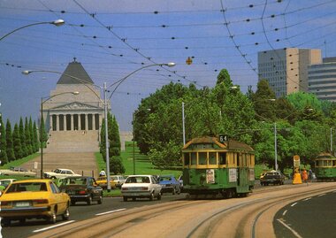 Melbourne Tram Museum
Postcard - St Kilda Road, Shrine of Remembrance W2 551, Nucolorvue Publishing, 1970c
Nu-color-vue postcard of W2 551 (Route 64, East Brighton via Caulfield) in St Kilda Road, passing the Shrine of Remembrance c1970. Has another W2 in front, route 5.Yields information about St Kilda Road and the Shrine c1970.Postcard - Nu-color-Vue - St Kilda Road, Shrine of Remembrance W2 551, divided back. card number ML 156 RP372trams, tramways, w2 class, shrine of remembrance, tram 551, route 64 -
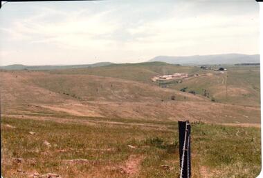 Hume City Civic Collection
Photograph, early 1980s
The Sunbury Tip was transferred from the end of Reservoir Road as housing development spread in that area to a site on the NW side of Mt. Holden near Riddell Road in the early 1980s.A landscape coloured photograph with rounded corners. It is a panoramic view of open country NW of Sunbury near Riddell Road. There is a fence post with barbed wire hanging from it in the immediate foreground and Macedon Ranges and part of the Western Highlands can be seen across the skyline.macedon ranges, mt. macedon, camel's hump, sunbury municipal tip, george evans collection -
Tatura Irrigation & Wartime Camps Museum
Photograph, 19/12/1946
Taken by photographer for State Rivers and Water Supply Commission.Medium sized black and white photograph. Waranga Reservoir main outlet - Western main channel looking downstream to Waranga. Concrete bridges and control structure join earthen banks of channel. Windmill mid-left of picture.goulburn weir, victorian state rivers and supply commission -
Glen Eira Historical Society
Letter - St. Stephen’s Presbyterian Church, Caulfield
Two documents regarding the historical significance of St. Stephen’s Church, 158 Balaclava Road Caulfield. The first document is correspondence dated 25/09/1990 from the National Trust informing the City of Caulfield of the inclusion of the church on the National Trust Register. The second document is a photocopy of the Caulfield Conservation Study by Andrew Ward dated February 1994. It includes an unclear front view photograph, references and recommends planning scheme control.city of caulfield, caulfield, caulfield north, balaclava road, kooyong road, st. stephen’s church, presbyterian church, uniting church, ward andrew, kinross george, currie george, haddon robert, architects, builders, churches, caulfield conservation study, national trust register, gothic revival architecture, architectural features, architectural styles, heritage studies, patios, windows, registers, symbols, fundraising events, religious ceremonies, religious groups