Showing 2286 items matching " parish."
-
 Whitehorse Historical Society Inc.
Document - Newsletter, St Edward's Church of England, 28/02/1966
Newsletter and report of the Annual General Meeting talking about plans to build a Vicarage and the separation of St Edward's Parish and asking for offerings in envelope system.st edward's anglican church, blackburn south, watson, raymond -
Whitehorse Historical Society Inc.
Document, Schwerkolt land Northcote, 1963?
Papers showing dealings and encumbrances relating to Portion 107, Parish of Jika Jika, Separation Street, Northcote, formerly owned by Johann August Schwerkolt.Papers showing dealings and encumbrances relating to Portion 107, Parish of Jika Jika, Separation Street, Northcote, formerly owned by Johann August Schwerkolt.Papers showing dealings and encumbrances relating to Portion 107, Parish of Jika Jika, Separation Street, Northcote, formerly owned by Johann August Schwerkolt.schwerkolt, johann august, separation street, northcote -
 St Patrick's Old Collegians Association (SPOCA)
Photograph - Alumni, General
-
 Bendigo Historical Society Inc.
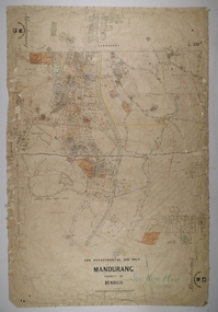
Map - MANDURANG 1, Examined 11/12/1879
Map: Mandurang 2, County of Bendigo. Parish plan Examined by W. S. Stephen 11.12.79 W. E. Porter Draughtsman July 1879map, bendigo, parish plan, mandurang, w. s. stephen, w. e. porter -
 Bendigo Historical Society Inc.
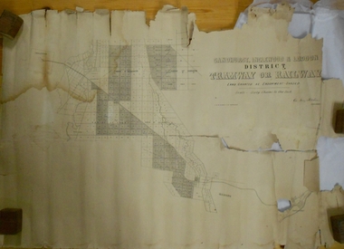
Map - MARKS COLLECTION: TRAMWAY OR RAILWAY MAP SANDHURST
Original map of 'land granted as endowment' for tramway or railway. On top Rh corner of map, in bold print 'Sandhurst, Inglewood & Loddon district Tramway or Railway. Land granted as endowment shaded, scale 60 chains to 1 inch. Lithographed by J & W. Holmes, Lith. Sandhurst'. Signed by Geo Avery Fletcher, Engineer. Map shows Parish of Leichardt, Parish of Yarraberb, Parish of Bridgwater and a section of Marong. On bottom RH corner, is small map of Sandhurst, showing railway reserve. Top LH corner, Inglewood. Map shows route of railway line from Sandhurst to Inglewood.map, marks collection, railway, inglewood -
 Ballarat Heritage Services
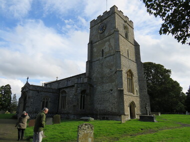
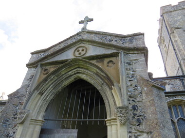
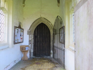
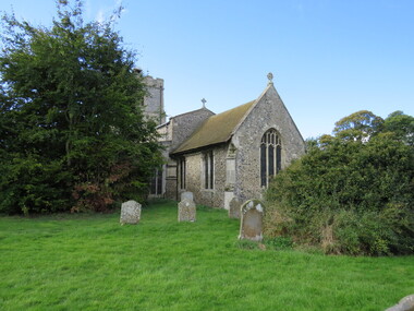
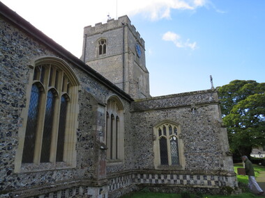
Photograph - Colour, St Mary's Church, Dullingham
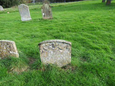
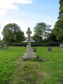
St Mary's Dullingham is a parish in the Raddesley Benefice. st mary's, dullingham, church, england, dullingham church pond, elizabeth symonds, stonework, masons, stonemasons, graves -
 Ballarat Heritage Services
Photograph - Colour, St Mary's Church, Dullingham
St Mary's Dullingham is a parish in the Raddesley Benefice. st mary's, dullingham, church, england, dullingham church pond, elizabeth symonds, stonework, masons, stonemasons, graves -
 Ballarat Heritage Services
Photograph - Colour, St Mary's Church, Dullingham
St Mary's Dullingham is a parish in the Raddesley Benefice. st mary's, dullingham, church, england, dullingham church pond, elizabeth symonds, stonework, masons, stonemasons, graves -
 Ballarat Heritage Services
Photograph - Colour, St Mary's Church, Dullingham
St Mary's Dullingham is a parish in the Raddesley Benefice. st mary's, dullingham, church, england, dullingham church pond, elizabeth symonds, stonework, masons, stonemasons, graves -
 Ballarat Heritage Services
Photograph - Colour, St Mary's Church, Dullingham
St Mary's Dullingham is a parish in the Raddesley Benefice. st mary's, dullingham, church, england, dullingham church pond, elizabeth symonds, stonework, masons, stonemasons, graves -
 Ballarat Heritage Services
Photograph - Colour, St Mary's Church, Dullingham
St Mary's Dullingham is a parish in the Raddesley Benefice. st mary's, dullingham, church, england, dullingham church pond, elizabeth symonds, stonework, masons, stonemasons, graves -
 Ballarat Heritage Services
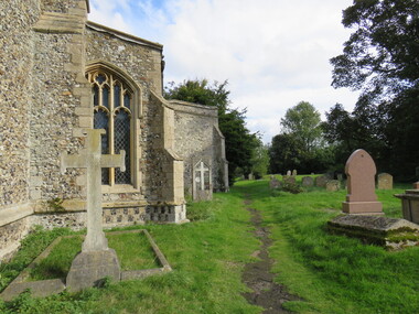
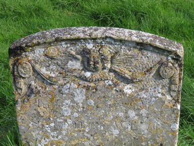
Photograph - Colour, Graves, St Mary's Church, Dullingham
St Mary's Dullingham is a parish in the Raddesley Benefice. st mary's, dullingham, church, england, dullingham church pond, elizabeth symonds, stonework, masons, stonemasons, graves -
 Ballarat Heritage Services
Photograph - Colour, Graves, St Mary's Church, Dullingham
St Mary's Dullingham is a parish in the Raddesley Benefice. st mary's, dullingham, church, england, dullingham church pond, elizabeth symonds, stonework, masons, stonemasons, graves -
 Ballarat Heritage Services
Photograph - Colour, Graves, St Mary's Church, Dullingham
St Mary's Dullingham is a parish in the Raddesley Benefice. st mary's, dullingham, church, england, dullingham church pond, elizabeth symonds, stonework, masons, stonemasons, graves -
 Ballarat Heritage Services
Photograph - Colour, Graves, St Mary's Church, Dullingham
St Mary's Dullingham is a parish in the Raddesley Benefice. st mary's, dullingham, church, england, dullingham church pond, elizabeth symonds, stonework, masons, stonemasons, graves -
 Ballarat Heritage Services
Photograph - Colour, Graves, St Mary's Church, Dullingham
St Mary's Dullingham is a parish in the Raddesley Benefice. st mary's, dullingham, church, england, dullingham church pond, elizabeth symonds, stonework, masons, stonemasons, graves -
 Ballarat Heritage Services
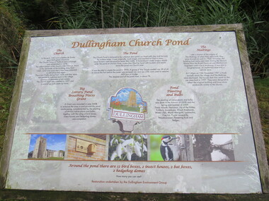
Photograph - Colour, Dullingham Church Pond sign, St Mary's Church, Dullingham
St Mary's Dullingham is a parish in the Raddesley Benefice. st mary's, dullingham, church, england, dullingham church pond, elizabeth symonds, stonework, masons, stonemasons, graves -
 Ballarat Heritage Services
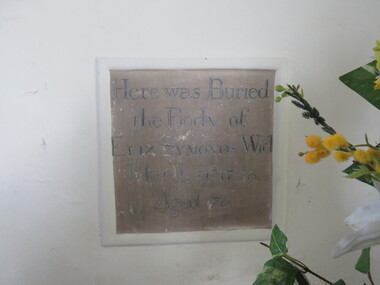
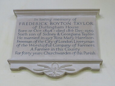
Photograph - Colour, Plaque, St Mary's Church, Dullingham
St Mary's Dullingham is a parish in the Raddesley Benefice. st mary's, dullingham, church, england, dullingham church pond, elizabeth symonds, stonework, masons, stonemasons, graves -
 Ballarat Heritage Services
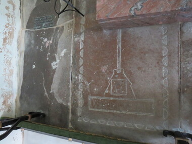
Photograph - Colour, Stonework, St Mary's Church, Dullingham
St Mary's Dullingham is a parish in the Raddesley Benefice. st mary's, dullingham, church, england, dullingham church pond, elizabeth symonds, stonework, masons, stonemasons, graves -
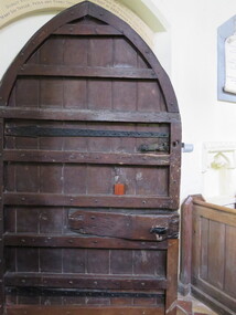 Ballarat Heritage Services
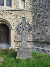
Photograph - Colour, Door, St Mary's Church, Dullingham
St Mary's Dullingham is a parish in the Raddesley Benefice. st mary's, dullingham, church, england, dullingham church pond, elizabeth symonds, stonework, masons, stonemasons, graves -
 Bendigo Historical Society Inc.
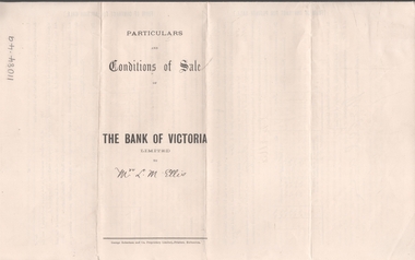
Legal record - ELLIS Edward Woodrow Tregenza - Land sale records, Watson, James & Rogers, Rogers Collection, 1907
In the early 1980s the firm of Watson, James & Rogers merged with the partnership of Every & Every and became the iconic “Rogers & Every” as known today. The firm is still located on Bull Street. https://rogersevery.com.au/about/* Particulars, conditions of sale and contract from bank of Victoria to Louisa Mary Ellis. 1907. * Plan of subdivision of crown allotments 20, 22, 23 Parish of Sandhurst, County of Bendigo * Agreement between Rupert Noyes Putnam of Williamson St. Bendigo and Edward Woodrow Tregenza Ellis of High St Bendigo for Crown allotments 18 and 19, Parish of Sandhurst County of bendigo.Signaturesrupert noyes putnam, land sales -
 Bendigo Historical Society Inc.
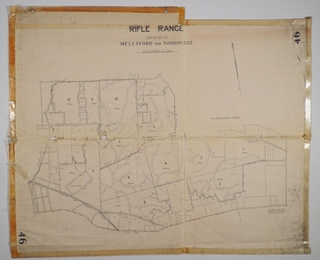
Map - CAMPBELL COLLECTION: BENDIGO AND DISTRICT MAPS
Map. Rifle Range, Parishes of Wellsford and Sandhurst. Scale 20 chains to 1 inch. Total area in plan is 5916 acres. Wallan and Bendigo Railway to Axedale Township and station 8 miles, to Longlea Railway Station 2 1/2 - 3 miles. Rifle Range. Compiled in W.P.B. from Assessment and Parish Plans, by H.A.D. 8-7-29H.A.D.(Darby).map, bendigo, allotments, bendigo rifle range, sandhurst parish, wellsford parish -
![Planning Document, Plan of proposed subdivision of land in Greensborough [Map shows Scotland house], 01/04/1971](/media/collectors/4f729f5697f83e03086015b8/items/5982a68921ea6b1420e4e560/item-media/59916fb521ea681094908d7a/item-fit-380x285.jpg) Greensborough Historical Society
Greensborough Historical SocietyPlanning Document, Plan of proposed subdivision of land in Greensborough [Map shows Scotland house], 01/04/1971
This subdivision of Greensborough shows the home of John Scotland (died 1888) and surrounding area bounded by Hailes, William, Lorimer, and Jessop Streets.Photocopy of plan, 2 pages.Part of plan (68G) of proposed subdivision of Greensborough, part of Crown Portion 18, Parish pf Keelbundora. Scale: 132 ft. to an inchjohn scotland, hailes street greensborough, william street greensborough, lorimer street greensborough, jessop street greensborough -
 Federation University Historical Collection
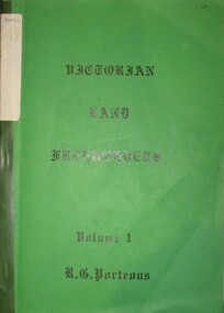
Book, Roger G. Porteous, Victorian Land Freeholders
Green soft covered book with green tape spine. The book includes names and dates of the first land freeholders listed on Ballaarat and district Parish Maps. -
City of Moorabbin Historical Society (Operating the Box Cottage Museum)
Pamphlet - St Finbar's Parish Church, East Brighton - Celebrating 150 Years 1848-1998, 1998
St Finbar's Roman Catholic Church corner of Nepean Highway and Centre Road, East Brighton.St Finbar's Roman Catholic Church East Brighton was erected in 1871 and was integral to the spiritual well being and social life of the early settlers.Four page AO5 brochure inviting people to join in historic 150 year celebration. Contains brief history of the Parish of St Finger's East Brighton.early settlers, parish of moorabbin, city of moorabbin, county of bourke, shire of moorabbin, were j.b., market gardeners, nepean highway, east brighton, st finbar's parish, centre road, religion, roman catholic -
 Bendigo Historical Society Inc.
Map - JACK FLYNN COLLECTION: KARA KARA, 1932
Map: County of Kara Kara, map sheet showing the whole of the County of Kara Kara and all of the Parishes within. Scale 2 miles to 1 inch.By Authority: W.M. Houston, Government Printer Melbourne. Department of Lands and Survey, Melbourne, 1958map, kara kara, county, kara kara -
Bendigo Historical Society Inc.
Map - SUTTON GRANGE, 10th July 1872
Map: Residence sites at Sutton Grange, being subdivision of Allotment 10 Sec. 3, Parish of Sutton Grange (number 275 in map cupboard 1)map, subdivision, sutton grange, residence sites, allotment 10 sec. 3 -
Whitehorse Historical Society Inc.
Article, Rayner Charges Fail, Resume, 14/02/1997
Archbishop Peter Carnley issues statement regarding charges brought against the Archbishop of Melbourne by the Reverend David Greentree re the Parish of St. Lukes, Vermont.st. lukes anglican church, vermont, greentree, david (rev), carnley, peter -
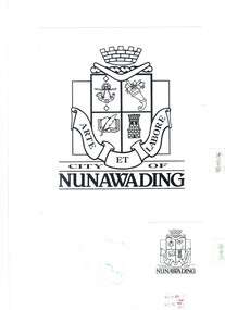 Whitehorse Historical Society Inc.
Artwork, other - Illustration, Original Coat Of Arms, 1/02/1993
Original art work for the Coat of Arms for the City of Nunawading. Accompanied by letter from Karen Parish, the designer. 3 pages within cardboard protective cover.city of nunawading, parish karen, coat of arms -
 Bendigo Historical Society Inc.
Document - History of 11 Mackenzie Street
Bendigo Historical Society moved into 11 Mackenzie Street, Bendigo in 2022. The BHS Collection has been installed in the building.Six-page history of the ownership of the property at 11 MacKenzie Street, Parish of Sandhurst, Bendigo from subdivision in 1894 to sale in 2021. through five owners. mackenzie street, historical society