Showing 6762 items matching " rivers"
-
 Lakes Entrance Historical Society
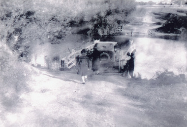
Photograph - Tambo Upper Punt, 1920
Black and white photograph showing two females and one male and car using punt to cross river, Punt man loosening guide chains in preparation for crossing. Shows both banks of Tambo River at Tambo Upper Victoria waterways, transport -
 Lakes Entrance Historical Society
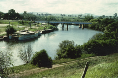
Photograph - Bridges, 1950
Colour photograph of unfinished Cataraman Llinase on Mitchell River, at Bairnsdale Wharf, railway bridge and highway bridge over the river, road to Paynesville under bridge, wharf on left, Mt Taylor and Mt Lookout in background. Bairnsdale Victoriabridges, waterways, boats and boating -
 Flagstaff Hill Maritime Museum and Village
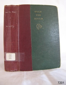
Book, Over The River
Pattison Collection This item is from the ‘Pattison Collection’, a collection of books and records that was originally owned by the Warrnambool Mechanics’ Institute, which was founded in Warrnambool in 1853. By 1886 the Warrnambool Mechanics’ Institute (WMI) had grown to have a Library, Museum and Fine Arts Gallery, with a collection of “… choice productions of art, and valuable specimens in almost every branch and many wonderful national curiosities are now to be seen there, including historic relics of the town and district.” It later included a School of Design. Although it was very well patronised, the lack of financial support led the WMI in 1911 to ask the City Council to take it over. In 1935 Ralph Pattison was appointed as City Librarian to establish and organise the Warrnambool Library as it was then called. When the WMI building was pulled down in 1963 a new civic building was erected on the site and the new Warrnambool Library, on behalf of the City Council, took over all the holdings of the WMI. At this time some of the items were separated and identified as the ‘Pattison Collection’, named after Ralph Pattison. Eventually the components of the WMI were distributed from the Warrnambool Library to various places, including the Art Gallery, Historical Society and Flagstaff Hill. Later some were even distributed to other regional branches of Corangamite Regional Library and passed to and fro. It is difficult now to trace just where all of the items have ended up. The books at Flagstaff Hill Maritime Village generally display stamps and markings from Pattison as well as a variety of other institutions including the Mechanics’ Institute itself. RALPH ERIC PATTISON Ralph Eric Pattison was born in Rockhampton, Queensland, in 1891. He married Maude Swan from Warrnambool in 1920 and they set up home in Warrnambool. In 1935 Pattison accepted a position as City Librarian for the Warrnambool City Council. His huge challenge was to make a functional library within two rooms of the Mechanics’ Institute. He tirelessly cleaned, cleared and sorted a disarrayed collection of old books, jars of preserved specimens and other items reserved for exhibition in the city’s museum. He developed and updated the library with a wide variety of books for all tastes, including reference books for students; a difficult task to fulfil during the years following the Depression. He converted all of the lower area of the building into a library, reference room and reading room for members and the public. The books were sorted and stored using a cataloguing and card index system that he had developed himself. He also prepared the upper floor of the building and established the Art Gallery and later the Museum, a place to exhibit the many old relics that had been stored for years for this purpose. One of the treasures he found was a beautiful ancient clock, which he repaired, restored and enjoyed using in his office during the years of his service there. Ralph Pattison was described as “a meticulous gentleman whose punctuality, floorless courtesy and distinctive neat dress were hallmarks of his character, and ‘his’ clock controlled his daily routine, and his opening and closing of the library’s large heavy doors to the minute.” Pattison took leave during 1942 to 1942 to serve in the Royal Australian Navy, Volunteer Reserve as Lieutenant. A few years later he converted one of the Museum’s rooms into a Children’s Library, stocking it with suitable books for the younger generation. This was an instant success. In the 1950’s he had the honour of being appointed to the Victorian Library Board and received more inspiration from the monthly conferences in Melbourne. He was sadly retired in 1959 after over 23 years of service, due to the fact that he had gone over the working age of council officers. However he continued to take a very keen interest in the continual development of the Library until his death in 1969. WARRNAMBOOL MECHANICS’ INSTITUTE Warrnambool's Mechanics' Institute (or Institution as it was sometimes called) was one of the earliest in Victoria. On 17th October 1853, a meeting was held where it was resolved to request the Lieutenant Governor of the Colony to grant land for the erection of a Mechanics' Institutes building. A committee was formed at the meeting and Richard Osburne chaired the first meeting of this committee. The land on the North West corner of Banyan and Merri Streets was granted but there were no funds to erect the building. The Formal Rights of the Warrnambool Mechanics' Institute's encompassed its aims and these were officially adopted in1859; "This Institution has for its object the diffusion of literary, scientific, and other useful knowledge amongst its members, excluding all controversial subjects, religious or political. These objects are sought to be obtained by means of a circulating library, a reading room, the establishment of classes, debates, and the occasional delivery of lectures on natural and experimental philosophy, mechanics, astronomy, chemistry, natural history, literature, and the useful and ornamental arts, particularly those which have a more immediate reference to the colony." The Warrnambool Mechanics' Institute opened its first reading room in November 1884 in the National School building at the corner of Banyan and Timor Streets. The Institute was funded by member subscription, payable on a quarterly, half-yearly or yearly basis. Samuel Hannaford, the Manager of the Warrnambool Bank of Australasia, was the first Honorary Secretary of the Mechanics' Institutes, and an early President and Vice-President. He also gave several of the early lectures in the Reading Room. Another early Secretary, Librarian and lecturer was Marmaduke Fisher, the teacher at the National School. Lecture topics included The Poets and Poetry of Ireland', 'The Birth and Development of the Earth', 'The Vertebrae - with Remarks on the pleasures resulting from the study of Natural History' and 'Architecture'. In 1856 the Reading Room was moved to James Hider's shop in Timor Street, and by 1864 it was located in the bookshop of Davies and Read. In the 1860's the Mechanics' Institute struggled as membership waned but in 1866, after a series of fundraising efforts, the committee was able to purchase land in Liebig Street, on a site then called Market Square, between the weighbridge and the fire station. A Mechanics' Institute building was opened at this site in August 1871. The following year four more rooms were added to the main Reading Room and in 1873 the Artisan School of Design was incorporated into the Institute. The same year Joseph Archibald established a Museum; however, it deteriorated when he was transferred to Bendigo in 1877. In 1880, with Archibald's return to Warrnambool, the Museum was re-established, and in 1885 a new building was built at the back of the Institute to accommodate the re-created School of Design, the Art Gallery and the Museum. In 1887 the Museum section was moved to the former courthouse in Timor Street (for some time the walls of the building formed part of the TAFE cafeteria but all is now demolished)). In 1911 the Museum was transferred back to the original building and the management of the Mechanics' Institute was handed over to the Warrnambool City Council. The Museum and Art Gallery became one and housed many fine works of art, and the Library continued to grow. The building was well patronised, with records showing that at the beginning of the 20th century there were between 500 and 800 visitors. During World War One the monthly figures were in the thousands, with 3,400 people visiting in January 1915. The Museum was a much - loved Institution in Warrnambool until the contents of the Museum and Art Gallery were removed to make room for the Warrnambool City Council Engineers' Department. The contents were stored but many of the items were scattered or lost. When the original building was demolished the site became occupied by the Civic Centre, which included the new City Library. (The library was temporarily located in the old Palais building in Koroit Street.) In the process of reorganisation the Collection was distributed amongst the community groups: -The new City Library took some of the historical books and some important documents, historic photographs and newspapers. -The Art Gallery kept the 19th Century art collection and some of the artefacts from the museum. -The Historical Society has some items -The State Museum has some items -Some items were destroyed -Flagstaff Hill Maritime Village has old newspapers, Government Gazettes, most of the Mechanics' Institute Library, ledgers and documents connected to the Mechanics' Institute Library, some framed and unframed artworks and some photographs. The Warrnambool Mechanics' Institute Library book collection is deemed to be of great importance because it is one of the few collections in an almost intact state, and many of the books are now very rare and of great value. The Pattison Collection, along with other items at Flagstaff Hill Maritime Village, was originally part of the Warrnambool Mechanics' Institute’s collection. The Warrnambool Mechanics’ Institute Collection is primarily significant in its totality, rather than for the individual objects it contains. Its contents are highly representative of the development of Mechanics' Institute libraries across Australia, particularly Victoria. A diversity of publications and themes has been amassed, and these provide clues to our understanding of the nature of and changes in the reading habits of Victorians from the 1850s to the middle of the 20th century. The collection also highlights the Warrnambool community’s commitment to the Mechanics’ Institute, reading, literacy and learning in the regions, and proves that access to knowledge was not impeded by distance. These items help to provide a more complete picture of our community’s ideals and aspirations. The Warrnambool Mechanics Institute book collection has historical and social significance for its strong association with the Mechanics Institute movement and the important role it played in the intellectual, cultural and social development of people throughout the latter part of the nineteenth century and the early twentieth century. The collection of books is a rare example of an early lending library and its significance is enhanced by the survival of an original collection of many volumes. The Warrnambool Mechanics' Institute’s publication collection is of both local and state significance. Over The River Author: John Galsworthy Publisher: William Heinemann Limited Date: 1933 The label on the spine with typed text PAT FIC GAL Pastedown front endpaper has a sticker from Warrnambool Mechanics Institute and Free Library covered by a sticker from Corangamite Regional Library Service Front loose endpaper has a stamp from Corangamite Regional Library Service shipwrecked-coast, flagstaff-hill, flagstaff-hill-maritime-museum, warrnambool, maritime-museum, shipwreck-coast, flagstaff-hill-maritime-village, shipwrecked-artefact, book, pattison collection, warrnambool library, warrnambool mechanics’ institute, ralph eric pattison, corangamite regional library service, warrnambool city librarian, mechanics’ institute library, victorian library board, warrnambool books and records, warrnambool children’s library, great ocean road, over the river, john galsworthy -
 Flagstaff Hill Maritime Museum and Village
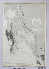
Document - Navigation Chart, Tavoy River
British Admiralty Navigation Chart - Bay of Bexgal - East Coast - Bruma - Tavoy Riverwarrnambool, shipwrecked-coast, flagstaff-hill, flagstaff-hill-maritime-museum, maritime-museum, shipwreck-coast, flagstaff-hill-maritime-village, shipwrecked-artefact, navigation chart, british admiralty navigation chart, british admiralty, tavoy river, bay of bexgal, bruma -
 Lorne Historical Society
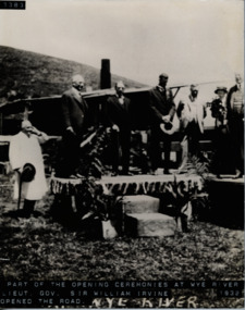
Photograph, Wye River Opening Ceremony 1932
Opening Ceremony at Wye River G.O.R 1932. Lt. Governor Sir William Irvinewye-river-opening-ceremony-1932. lt-govenor-sir-william-irvine -
 Lorne Historical Society
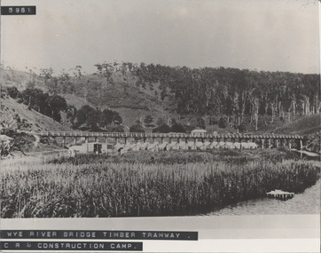
Photograph - Black and white photograph, Wye River Bridge Timber Tramway
Photograph showing the Wye River Bridge Timber Tram way at the C.R.B Construction Campwye-river-bridge, timber-tramway, c.r.b.-construction-camp, wye river bridge, timber tramway, c.r.b. construction camp, country roads board -
 Phillip Island and District Historical Society Inc.
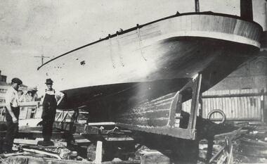
Photograph, 1930
One of a collection of over 400 photographs in an album commenced in 1960 and presented to the Phillip Island & Westernport Historical Society by the Shire of Phillip IslandPhotograph of W. J. Kennon & D. Justice building the "Hollydene" at Saltwater River. 1930local history, photography, photographs, ship building, "hollydene" under construction, black & white photograph, fishing boats, hollydene, w j kennon, d justice, john jenner, bryant west -
 Glenelg Shire Council Cultural Collection
Negative - Negative - Nelson, Victoria, 1934
Part of a collection of photographs taken by Zillah Maschmedt in 1934. Zillah was a teacher from South Australia.Transparency for black and white photo. Nelson, Victoria, Glenelg River in foreground, bridge on left.zillah maschmedt, photography, nelson, glenelg river -
Glenelg Shire Council Cultural Collection
Negative - Negative - Nelson Victoria, Glenelg River in background, c. 1936
Transparency for black and white photo. Nelson Victoria, Glenelg River in background, ocean in distance. -
 Halls Gap & Grampians Historical Society
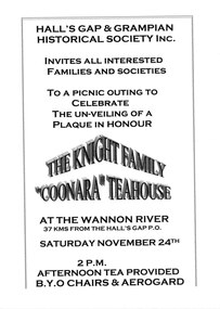
Flyer - B/W, C November 2001
Halls Gap & Grampians Historical Society flyer for picnic outing to celebrate the unveiling of a commemorative plaque in honour of the Knight Family Coonara Teahouse. The unveiling was to take place on 24 November 2001.A copy of a flyer advertising the unveiling of a plaque at the site of the "Coonara" tea-rooms on the Wannon River.media, flyers -
 Eltham District Historical Society Inc
Photograph, Aerial view of Yarra River near Kangaroo Ground - Bend of Islands area
Sepia aerial view of Yarra river at Bend of Islands; Henley Road on left in foregroundbend of isles, kangaroo ground, yarra river, henley road -
 Eltham District Historical Society Inc
Photograph, George W. Bell, River Flats, Sweeneys Lane, 1960s
Black and white photograph Yarra River Flats, Sweeneys Lane, Eltham c.1960ssweeneys lane, yarra river, eltham, farming, george w bell collection -
 Eltham District Historical Society Inc
Photograph, George W. Bell, River Flats, Sweeneys Lane, 1960s
Black and white photograph of Yarra River Flats, Sweeneys Lane, Eltham c.1960s.sweeneys lane, yarra river, eltham, farming, george w bell collection -
 Eltham District Historical Society Inc
Photograph, Doug Orford, Yarra River from Eltham-Templestowe Footbridge, 2004, 2004
Two colour photographs of Yarra River upstream and downstream from Eltham-Templestowe footbridgeyarra river, bridges, eltham, eltham south, templestowe, eltham lower park, lenister farm -
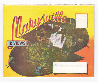 Marysville & District Historical Society
Postcard (item) - Colour photographs, Murray Views, Marysville 12 Views, 1950's
A fold out postcard of 12 colour photographs of scenes and landscapes in and around Marysville in Victoria.A fold out postcard 12 colour photographs of scenes and landscapes in and around Marysville in Victoria. These photographs were produced by Murray Views in Gympie, Queensland as a souvenir of Marysville.Marysville/ 12 VIEWS PRODUCED BY MURRAY VIEWS./ GYMPIE./ Q COPYRIGHT SAMUEL LEE & CO., PRINTERS. STEAVENSON'S FALLS, MARYSVILLE, VIC. TOURISTS AT MARYSVILLE, VIC. "FRUIT SALAD FARM", MARYSVILLE MAIN STREET, MARYSVILLE, VIC. ROAD SCENE, MARYSVILLE, VIC. THE CROSSWAYS, MARYSVILLE, VIC ROAD TO CUMBERLAND VALLEY, MARYSVILLE PANORAMA FROM BLACK SPUR, MARYSVILLE ROAD, MARYSVILLE, VIC. NICHOLL'S LOOKOUT, MARYSVILLE, VIC. TREE FERNS, MARYSVILLE, VIC. THE BRIDGE, MARYSVILLE, VIC.steavenson falls (image 1), tourists in marysville (image 2), taggerty river (image 3), fruit salad farm (image 4), main street marysville (image 5), road scene marysville (image 6), the crossways (image 7), cumberland valley (image 8), black spur (image 9), nicholl's lookout (image 10), tree ferns (image 11), bridge (image 12), marysville, victoria, postcard, souvenir, murray views -
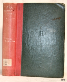 Flagstaff Hill Maritime Museum and Village
Book, Sick Heart River
This book was part of a large group of books referred to as the Pattison Collection, which belonged to the Warrnambool Public Library, part of the Warrnambool Mechanics’ Institute. About RALPH ERIC PATTISON and the ‘PATTISON COLLECTION’ The ‘Pattison Collection’ is a collection of books and records that was originally owned by the Warrnambool Mechanics’ Institute, founded in Warrnambool in 1853. By 1886 the Warrnambool Mechanics’ Institute (WMI) had grown to have a Library, Museum and Fine Arts Gallery, with a collection of “… choice productions of art and valuable specimens in almost every branch and many wonderful national curiosities, are now to be seen there, including historic relics of the town and district.” It later included a School of Design. Although it was very well patronised, the WMI was led to ask the City Council to take it over in 1911 due to a lack of financial support. In 1935 Ralph Pattison was appointed as City Librarian to establish and organise the Warrnambool Public Library as it was then called. Ralph Eric Pattison was born in Rockhampton, Queensland, in 1891. He married Maude Swan from Warrnambool in 1920 and they set up a home in Warrnambool. In 1935 when Pattison accepted the position as City Librarian for the Warrnambool City Council his huge challenge was to make a functional library within two rooms of the Mechanics’ Institute. He tirelessly cleaned, cleared and sorted a disarrayed collection of old books, jars of preserved specimens and other items reserved for exhibition in the city’s museum. He developed and updated the library with a wide variety of books for all tastes, including reference books for students; a difficult task to fulfil during the years following the Depression. He converted all of the lower areas of the building into a library, reference room and reading room for members and the public. The books were sorted and stored using a cataloguing and card index system that he had developed himself. He also prepared the upper floor of the building and established the Art Gallery and later the Museum, a place to exhibit the many old relics that had been stored for years for this purpose. One of the treasures he found was a beautiful ancient clock, which he repaired, restored and enjoyed using in his office during the years of his service there. Ralph Pattison was described as “a meticulous gentleman whose punctuality, floorless courtesy and distinctive neat dress were hallmarks of his character, and ‘his’ clock controlled his daily routine and his opening and closing of the library’s large heavy doors to the minute.” Pattison took leave from 1942 to 1945 to serve in the Royal Australian Navy, Volunteer Reserve as Lieutenant. A few years later he converted one of the Museum’s rooms into a Children’s Library, stocking it with suitable books for the younger generation. This was an instant success. In the 1950’s he had the honour of being appointed to the Victorian Library Board and received more inspiration from the monthly conferences in Melbourne. He was sadly retired in 1959 after over 23 years of service, due to the fact that he had gone over the working age of council officers. However, he continued to take a very keen interest in the continual development of the Library until his death in 1969. THE NEW WARRNAMBOOL LIBRARY When the WMI building was pulled down in 1963 a new civic building was erected on the site and the new Warrnambool Library, on behalf of the City Council, took over all the holdings of the WMI. At this time some of the items were separated and identified as the ‘Pattison Collection’, named after Pattison. Eventually, the components of the WMI were distributed from the Warrnambool Library to various places, including the Art Gallery, Historical Society and Flagstaff Hill. Later some were even distributed to other regional branches of Corangamite Regional Library and passed to and fro. It is difficult now to trace just where all of the items have ended up. The books at Flagstaff Hill Maritime Village generally display stamps and markings from Pattison as well as a variety of other institutions including the Mechanics’ Institute itself. The Pattison Collection, along with other items at Flagstaff Hill Maritime Village, was originally part of the Warrnambool Mechanics' Institute’s collection. The Warrnambool Mechanics’ Institute Collection is primarily significant in its totality, rather than for the individual objects it contains. Its contents are highly representative of the development of Mechanics' Institute libraries across Australia, particularly Victoria. A diversity of publications and themes has been amassed, and these provide clues to our understanding of the nature of and changes in the reading habits of Victorians from the 1850s to the middle of the 20th century. The collection also highlights the Warrnambool community’s commitment to the Mechanics’ Institute, reading, literacy and learning in the regions, and proves that access to knowledge was not impeded by distance. These items help to provide a more complete picture of our community’s ideals and aspirations. The Warrnambool Mechanics Institute book collection has historical and social significance for its strong association with the Mechanics Institute movement and the important role it played in the intellectual, cultural and social development of people throughout the latter part of the nineteenth century and the early twentieth century. The collection of books is a rare example of an early lending library and its significance is enhanced by the survival of an original collection of many volumes. The Warrnambool Mechanics' Institute’s publication collection is of both local and state significance. Sick Heart River Author: John Buchan Publisher: Hodder & Stoughton Date: 1941 The label on the spine cover with typed text PAT FIC BUC Pastedown front endpaper has a sticker from Warrnambool Public Library, with the date 7th July 1951 The front loose endpaper has a sticker from Corangamite Regional Library Service. Flyleaf has a stamp from Warrnambool Mechanics Institute and Free Library. flagstaff hil, warrnambool, flagstaff hill maritime museum, maritime museum, shipwreck coast, flagstaff hill maritime village, great ocean road, book, pattison collection, warrnambool library, warrnambool mechanics’ institute, ralph eric pattison, corangamite regional library service, warrnambool city librarian, mechanics’ institute library, victorian library board, warrnambool books and records, warrnambool children’s library, sick heart river, john buchan -
 Bendigo Historical Society Inc.
Photograph - ROBERT DENIS KELLY COLLECTION: BRIDGE OVER RIVER
Black and white photo: a double arch bridge over river. On the back: Bridge Biesmes. -
 Bendigo Historical Society Inc.
Slide - VAL DENSWORTH COLLECTION: LAKE EPPALOCK, 1986
Negative. Lake Eppalock spillway, Campaspe River at the base of the spillway. Dated November 1986slide, bendigo, lake eppalock, lake eppalock spillway campaspe river -
 Bendigo Historical Society Inc.
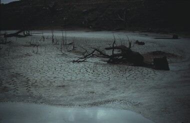
Slide - VAL DENSWORTH COLLECTION: DRY LAKE EPPALOCK, May 2004
Slide. Dry Lake Eppalock. Mud pools and dead trees along the river in the Lake.slide, bendigo, dry lake eppalock., dry lake eppalock. -
 Victorian Interpretive Projects Inc.
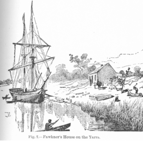
Digital Image, Fawkner's House (Melbourne), c1903
John Fawkner was an early settler of Melbourne, Victoria.Sketch of John Fawkner's house in Melbourne. The sketch shows a sailing vessel in the Yarra River.john fawkner, melbourne, yarra, yarra river, sailing boat -
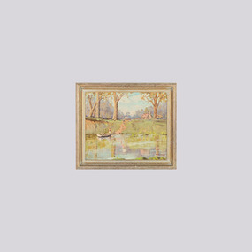
 Benalla Art Gallery
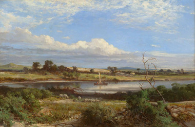
Painting, Abram Louis BUVELOT, The Barwon, 1870
Born Morges, Vaud, Switzerland 1814; Arrived Australia: 1865; Died: Victoria 1888ColonialLedger Gift, 1986Sailing boat on river in middle of landscape and sheep are grazing. Gold painted timber frame.Recto: Signed " L Buvelot/ 1870" in brown paint l.r.c of composition; Not titledwaterscape, boat, river, animals, house, colonial, landscape, australian art -
Tatura Irrigation & Wartime Camps Museum
Photograph, 2001
Sir Ronald East standing mid Murray River near Nyah in drought yearphotograph, people -
 Robin Boyd Foundation
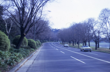
Slide, Robin Boyd, 1967
Colour slide in a mount. Alexandra Parade, by the Yarra River, South Yarra, Victoria, AustraliaMade in Australia / 28 / JUN 67M6 / Encircled 34 (Handwritten)slide, robin boyd -
 Wangaratta Art Gallery
Painting, John Colin Angus, Ratray's Store and Punt - Crossing the Ovens - 1839, 1963
Rural City of Wangaratta CollectionA landscape of a river crossing painted in oil using shades of green, brown, blue, and white.J. Colin Angus/ (bottom right corner)wangaratta art gallery, j colin angus, john colin angus, landscape painting -
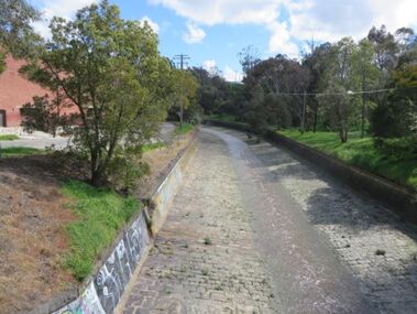 Ballarat Heritage Services
Photograph, Bluestone Channel near Sunnyside Mill, Ballarat, 04/09/2022
Bluestone Channel near Sunnyside Mill, Ballarat. The Channel holds the Yarrowee River, Ballarat.yarrowee river, yarrowee creek, sunnyside corner, channel, bluestone -
 Kew Historical Society Inc
Photograph - Yarra River, Kew, 1953
Black and white photograph of the River Yarra at Kew taken by Sydney Walter Jackson in 1953Nilyarra river -- kew (vic.) -
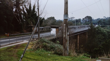 Kew Historical Society Inc
Photograph - Chandler Highway Bridge, Stewart West, 2001
Colour photograph by Stuart West of the Chandler Highway Bridge from the Fairfield side of the River.Nilchandler highway bridge, stewart west -
 Kew Historical Society Inc
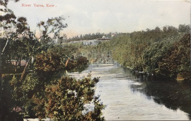
Postcard, River Yarra, Kew, 1918-1930
The Kew Historical Society's postcard collection includes views of Kew, Melbourne and Greater Melbourne as well as those including overseas scenes sent or received from Europe or the Middle East. They date from the 1890s to the 2000s. These postcards may or may not include the name of the publisher or printer. A number of the cards were published as parts of popular series. A way of dating early postcards is to identify whether the reverse was divided by a central line which became the norm after 1902 in the United Kingdom. However, other postcards produced after this date do not always conform to this print layout.The item forms part of the Laurie Bennett collection of thirty-six postcards and photographs of Kew and early Melbourne, donated to the Kew Historical Society in 1980. The postcards in the Bennett collection, like other images in the Society's holdings date from the 1890s to the present and comprehensively indicate points-of-view or scenes considered historically, aesthetically or socially significant in the period in which they were produced.Colour-tinted postcard of the River Yarra at Kew, showing the Kew Lunatic Asylum in the distance.KH-395 .Donated by L. Bennett, 1980river yarra - kew -
 Kew Historical Society Inc
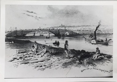
Photograph - Photograph (copy), S T Gill, Eastern side of Princess Bridge From Yarra, 1860-1880 (original)
Copy of a painting (or etching) by S.T. Gill showing the Yarra River at Princess Bridge, Melbourne.Inscription reverse: "Eastern side of old Princess Bridge from Yarra"reproductions -- s t gill, princess bridge -- river yarra - melbourne (vic.) -
 Kew Historical Society Inc
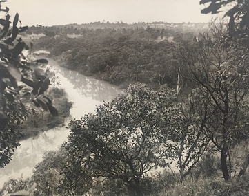
Photograph, J E & B L Rogers, View of Yarra from Cliffs, Studley Park, 1958
This work forms part of the collection assembled by the historian Dorothy Rogers, that was donated to the Kew Historical Society by her son John Rogers in 2015. The manuscripts, photographs, maps, and documents were sourced by her from both family and local collections or produced as references for her print publications. Many were directly used by Rogers in writing ‘Lovely Old Homes of Kew’ (1961) and 'A History of Kew' (1973), or the numerous articles on local history that she produced for suburban newspapers. Most of the photographs in the collection include detailed annotations in her hand.The Rogers Collection provides a comprehensive insight into the working habits of a historian in the 1960s and 1970s. Together it forms the largest privately-donated collection within the archives of the Kew Historical Society.Back and white photograph of the Yarra River at Kew. In the distance the towers of the Kew Asylum are visible."View of Yarra from Cliffs, Studley Park" / "Studley Park" / "Jim's" / "58"yarra river -- kew (vic), landscape photography