Showing 10613 items
matching sites
-
 Hume City Civic Collection
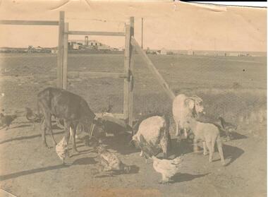
Photograph
'Amy's pets having breakfast' is written on the back of the photograph.A sepia photograph of farmyard animals: calf, 2 lambs, a goat and various hens in an enclosed yard. There is an industrial site in the background.animals, calves, livestock, goats, george evans collection -
 Lakes Entrance Regional Historical Society (operating as Lakes Entrance History Centre & Museum)
Book, Anderson F B, Colquhoun Railway Siding and Railway Spur, 2000
Research and interpretation of the history of the Colquhoun, East Gippsland, railway siding and railway spur, and suggested management of the site by Forestec studend.transport, timber industry -
 Whitehorse Historical Society Inc.
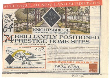
Newspaper - Advertisement, Knightsbridge Subdivision, 30/04/1997
Advertisment for Knightsbridge, Dunlavin Road Nunawading. 64 Brilliantly positioned prestige home sites priced from $95,000 to $129,950.knightsbridge subdivision, dunlavin road nunawading -
Whitehorse Historical Society Inc.
Article, Council haggles over site of school, 2014
Full cost of land at $15,000,000 too high for Whitehorse Council to pay the State Government for the Nunawading Primary School site.Full cost of land at $15,000,000 too high for Whitehorse Council to pay the State Government for the Nunawading Primary School site.Full cost of land at $15,000,000 too high for Whitehorse Council to pay the State Government for the Nunawading Primary School site.nunawading primary school no. 4190, springview primary school blackburn north, whitehorse primary school, junction road, blackburn north, ellis, sharon, ryall, dee -
 Whitehorse Historical Society Inc.
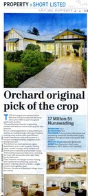
Article, Orchard original pick of the crop, 2011
The pictured house at 17 Milton Street Nunawading was part of the Belmont Orchard Estate with 66 home sites sold in 1924.The pictured house at 17 Milton Street Nunawading was part of the Belmont Orchard Estate with 66 home sites sold in 1924.The pictured house at 17 Milton Street Nunawading was part of the Belmont Orchard Estate with 66 home sites sold in 1924.belmont orchard estate, milton street nunawading, no. 17 -
Whitehorse Historical Society Inc.
Document - Agenda, Public Meeting, 17/11/1993
Agenda for public meeting of Schwerkolt Cottage Site Management Review, Courtyard Room, City of Nunawading, 17/11/1993schwerkolt cottage, city of nunawading, shambrook, tim, brandenburg, john p, city of nunawading. parks and recreation department -
 Whitehorse Historical Society Inc.
Photograph, Old Dam - Corner of Blackburn and Canterbury Road, c1910
Original photo at Blackburn Lake Education Centre. Dorothy Meagher loaned photo so a print could be made.Black and white photograph of children playing on the dam on the corner of Blackburn and Canterbury Roads, Blackburn. The Bellbird Hospital is now on the site.canterbury road, blackburn, blackburn road, blackburn lake education centre, meagher, dorothy, bellbird private hospital -
 Whitehorse Historical Society Inc.
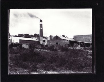
Photograph, Builders Trading & Roofing Co Ltd (formerly Monarch Pottery)
Monarch Pottery Site purchased by Builders Trading & Roofing Co. Ltd. c1918 - known locally as 'Builders Tile Works'monarch pottery, builders trading and roofing co. ltd. -
 Whitehorse Historical Society Inc.
Photograph, Blackburn Bowling Club, C.1926
Black and white photo of Tom Bysouth, Road Contractor, on site of Blackburn Bowling Club, now R.S.L. Bowling Club.blackburn bowling club, r.s.l. bowling club, bysouth, tom -
 Whitehorse Historical Society Inc.
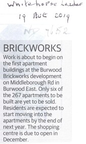
Article, Brickworks, 2019
Work is about to begin on the 267 residential apartments at the Burwood Brickworks site.Work is about to begin on the 267 residential apartments at the Burwood Brickworks site of which 261 have been pre-sold.Work is about to begin on the 267 residential apartments at the Burwood Brickworks site.brickworks, burwood east, middleborough road, burwood east -
 Ballarat Heritage Services
Photograph - Colour, Clare Gervasoni, The site of Marylands at Marysville after 'Black Saturday', 2012, 15/12/2012
Colour photographs of the site of Marysville's Marylands, the first in the famous Mary chain of guesthouses. Maryslands was destroyed in the 'Black Saturday' bushfire.bushfire, black saturday, marysville, marylands, mary chain -
 Ballarat Heritage Services
Photograph - Colour, Clare Gervasoni, The site of Marylyn Guest House at Marysville after 'Black Saturday', 2012, 15/12/2012
Colour photographs of the site of Marysville's Marylands, the first in the famous Mary chain of guesthouses. Maryslands was destroyed in the 'Black Saturday' bushfire.bushfire, black saturday, marysville, mary chain -
 Ballarat Heritage Services
Photograph - Colour, Clare Gervasoni, The Site of Marylands at Marysville after 'Black Saturday', 2014, 15/12/2012
Colour photographs of the site of Marysville's Marylands, the first in the famous Mary chain of guesthouses. Maryslands was destroyed in the 'Black Saturday' bushfire.bushfire, black saturday, marysville, marylands, mary chain -
 Whitehorse Historical Society Inc.
Photograph, Vermont Primary School
Coloured photograph of a section of the original Vermont Primary School building, now on the Nurlendi Road site. 31/10/2006vermont primary school no. 1022 -
 International House, The University of Melbourne
Photograph (Sub-Item), Victorian house on the site of International House at the University of Melbourne, c. 1957
buildings, royal parade, architecture -
 Lakes Entrance Regional Historical Society (operating as Lakes Entrance History Centre & Museum)
Photograph
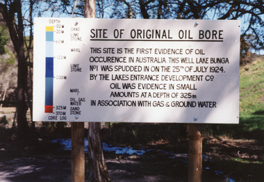
Seven other colour photographs very similar, before and after the bore was decommissioned and plugged 1996.Colour photograph of the sign at the Bunga Oil Bore site, on old Lake Tyers Road, near Lakes Entrance, Victoria.historic site, oil and gas industry -
 Lakes Entrance Regional Historical Society (operating as Lakes Entrance History Centre & Museum)
Photograph, 1999
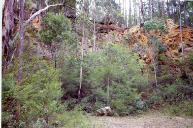
Quarry opened and tramline built after 1905 by Coate Brothers, contractors for Entrance works.Colour photograph taken at the abandoned Mississippi Creek Quarry showing natural vegetation encroaching the site. Lakes Entrance Victoriatransport -
 Lakes Entrance Regional Historical Society (operating as Lakes Entrance History Centre & Museum)
Photograph, 1918 c
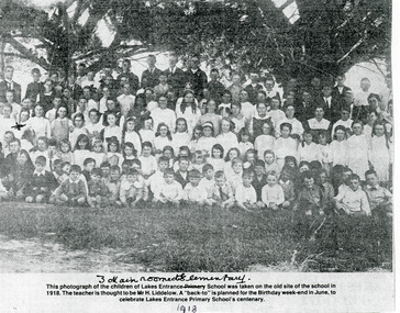
Paper photocopy of large group of children of Lakes Entrance Primary School taken on the site of the school. Lakes Entrance Victoriaschools -
Lakes Entrance Regional Historical Society (operating as Lakes Entrance History Centre & Museum)
Photograph, M Holding, 2006 c
Colour photograph of construction on site of Vi Symmons home immediately west of Bakery and Toy Kingdom Lakes Entrance Victoriabusinesses, buildings -
Lakes Entrance Regional Historical Society (operating as Lakes Entrance History Centre & Museum)
Photograph, 1950 c
Black and white photograph of an early home built DYO caravan on site at Carpenters Camp Park Lakes Entrance VictoriaThis is an Happy Home for as fortnightgenealogy, houses -
 Mt Dandenong & District Historical Society Inc.
Photograph, Mission Hall at Olinda in Snow
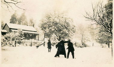
Three people playing in snow outside the Mission Hall in the Main Street of Olinda. Current Mangana Store covers this site.On back of photograph - Mission hall OLINDA. Mission Hall Olinda in the snow.olinda, mission hall, snow -
![1986-067.1 [1st above] craning the QUEENSCLIFFE onto boat rollers / 1986.067.2 [2nd above] Two cranes moving the QUEENSCLIFFE INTO POSITION / 1986.067.3 and 4 earlier shots of the two cranes maneuvering the QUEENSCLIFFE](/media/collectors/4f729f7e97f83e03086018d1/items/634f479a46349cf64a758143/item-media/634f49f346349cf64a75bc4c/item-fit-380x285.jpg) Queenscliffe Maritime Museum
Queenscliffe Maritime MuseumPhotograph - Moving Lifeboat into the QMM, Colour Photograph set
lifeboat QUEENSCLIFFE being preservedLifeboatColour photographs of the QUEENSCLIFFE Lifeboat being loaded onto a low-loader trailer to move it to the QMM site [66.1 and 66.2]Reverse - NILcommunity information, the queenscliffe lifeboat -
 Bendigo Historical Society Inc.
Slide - 112 Eaglehawk Road Bendigo
112 Eaglehawk Road Bendigo - an Edwardian Cottage. A google search on street view shows a newer home built on this site.history, bendigo, national trust collection bendigo, 112 eaglehawk road bendigo -
University of Melbourne, Burnley Campus Archives
Plan - Photocopy, Sketch Plan, 1929
Photocopy of hand drawn plan of Section of Site indicating proposed irrigation. Probably from A.W. Jessep memos 1929.irrigation, a.w. jessep -
Canterbury History Group
Ephemera - 39 Chatham Road Canterbury, [2000]
Real estate advertisement for the sale of 39 Chatham Road Canterbury[2000}. Includes sketch of the house and floor and site plancanterbury, chatham road, edwardian style, tennis courts -
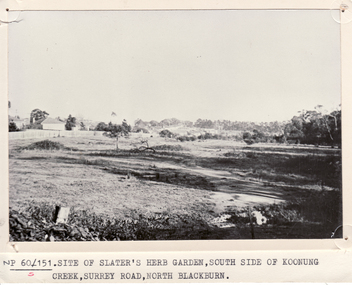 Whitehorse Historical Society Inc.
Photograph - B/W Photograph, Slater's herb garden, Blackburn, 1/06/1969 12:00:00 AM
Black and white photo showing site of Slater's herb garden on south side of Koonung Creek, Surrey Road, Blackburn.slater, william henry, herb gardens -
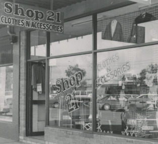 Lakes Entrance Regional Historical Society (operating as Lakes Entrance History Centre & Museum)
Photograph
Myer Street Shop Lakes Entrance 19.6.1991Black and white photograph of exterior of Shop 21 Clothing store when situated at 21 Myer Street established at this sitebusinesses, commerce -
 Lakes Entrance Regional Historical Society (operating as Lakes Entrance History Centre & Museum)
Photograph, 2008
Date made August 2008Colour photograph of a vacant allotment which was the site of the old All Nations hotel, Palmers Road, Lakes Entrance, Victoria.hotels, vegetation, room display -
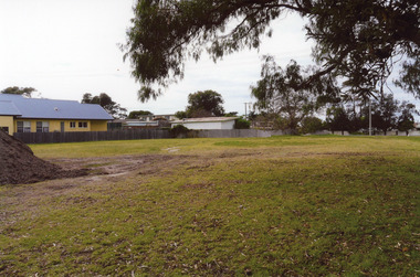
 Lakes Entrance Regional Historical Society (operating as Lakes Entrance History Centre & Museum)
Photograph, 2008
Date made August 2008Colour photograph of two brick units in Bung Yarnda Court. This is the site of the original Merrangbaur House. Lakes Entrance Victoriaguesthouses, architecture, room display -
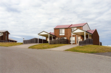
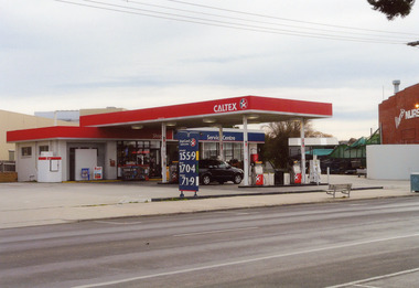 Lakes Entrance Regional Historical Society (operating as Lakes Entrance History Centre & Museum)
Photograph - Coates family, 2008
Date made August 2008Colour photograph of the Caltex garage on the Esplanade, garden nursery on the right. This was the site of Joseph Coates residence. Lakes Entrance Victoriaretail trade, room display, genealogy, local history