Showing 2476 items matching " township"
-
 Kiewa Valley Historical Society
Photograph of Kiewa Valley Panorama, Kiewa Valley from No. 5 Road, Before 1945
In 1943 a camp for workmen was erected and a commencement made with the erection of plant storage and workshop buildings in the new township of Mt. Beauty. The photograph was probably taken after the completion of these buildings. There is no sign of construction of the town itself. In the latter part of 1945 work was commenced on the Mt. Beauty township area with a medical centre, general trading store and some houses under construction. The No. 5 Road, from where the photograph was taken, is the road to West Kiewa Power Station and Big Hill Scenic Lookout.Is an excellent view of the Kiewa Valley before there was little work undertaken to establish the town of Mt. Beauty. Farming was well established with the evidence of huge areas of cleared land. The junction of the East and West Kiewa Rivers can be clearly seen. The first Workmen's camp is near the river and some workshop buildings can also be seen. Black and white photograph of the Kiewa Valley, looking North.Handwritten on the back of photograph "Kiewa Valley from No. 5 Road".kiewa valley, camp, buildings, mt. beauty -
 Bendigo Historical Society Inc.
Map - REDCASTLE : COUNTY OF BENDIGO, 10-8-08
Map. Redcastle, County of Bendigo, County of Rodney, Cornella, Cherrington, Dargile, Crosbie, Cornella Creek, Redcastle Creek, Mount Camel, Township of Redcastle. Photo-Lithographed at the Department. of Lands and Survey, Melbourne by T.F. McGaraun 10-8-08. (number 109 in map cupboard 1)T.F. McGaraunmap, bendigo, redcastle -
Bendigo Historical Society Inc.
Map - RAVENSWOOD : COUNTY OF BENDIGO, 1971
Map. Ravenswood, County of Bendigo, Township of Ravenswood, County of Talbot, Bradford; Walmer; Harcourt; Lockwood; Mandurang; Sutton Grange.By Authority C.H.Rixon, Government Printer, Melbourne.Drawn and Reproduced at the Dept. of Crown Lands and Survey, Victoria. 1971. Price $1.00 (number 5 in map cupboard 1)C.H.Rixon, Government Printermap, bendigo, ravenswood -
Clunes Museum
Book, "THE PAKENHAM GAZETTE", MAIN STREET, PAKENHAM, A VALLEY OF THE FINEST DESCRIPTION, 1985
A SOCIAL AND ENVIRONMENTAL HISTORY OF LEXTON SHIRE.BLUE BOUND BOOK WITH THE SHIRE OF LEXTON SEAL IMPRINTED IN GOLD LETTERING ON THE FRONT COVER, COMPLETE WITH DUST JACKET DEPICTING AN IMAGE OF A HORSE TEAM ENTERING THE TOWNSHIP OF LEXTON WITH THE PYRENEES HOTEL AND THE LEXTON COURT HOUSE, DERIVED FROM A PAINTING BY ANN MCGREGORD OF BURNBANK. 360 PAGESnon-fictionA SOCIAL AND ENVIRONMENTAL HISTORY OF LEXTON SHIRE.local history, book, history, lexton -
 Linton and District Historical Society Inc
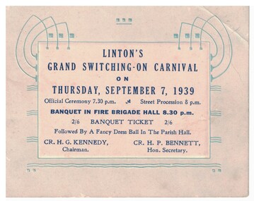
Card - Banquet Ticket, Linton's Grand Switching-On Carnival, 1939
Card with decoration of blue abstract electric lines on pale blue background. White square in centre of card with dark blue printing. Ticket is printed with details of an official ceremony, street procession, a banquet and a fancy dress ball to celebrate the connection and switching on of electricity to the township of Linton in 1939. Text: LINTON'S / GRAND SWITCHING-ON CARNIVAL / ON / THURSDAY, SEPTEMBER 7, 1939 / Official Ceremony 7.30 p.m. Street Procession 8 p.m. / BANQUET IN FIRE BRIGADE HALL 8.30 p.m.electricity, celebrations -
 Clunes Museum
Photograph, BEAUCHAMP PHOTOGRAPHY, C 1881
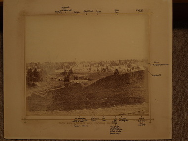
SEPIA PHOTOGRAPH OF CLUNES TOWNSHIP, TAKEN FROM ANGUS STREET HILL, LOOKING SOUTH; BUILDINGS INCLUDE WESLEY CHURCH, TOWN HALL, CATHOLIC CHURCH, C. OF E. CHURCH; CLUB HOTEL AND BANKS IN FRASER STREET; LIBRARY, FIRE BRIGADE BELL TOWER - FAR RIGHT.photographs, clunes township -
 Clunes Museum
Photograph, BEAUCHAMP PHOTOGRAPHY, FROM ANGUS STREET HILL, LOOKING SOUTH, 1879
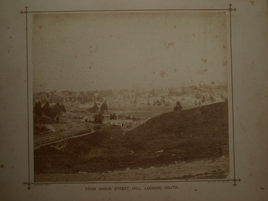
PHOTOGRAPH OF TOWNSHIP OF CLUNES ABOUT 1875. LOOKING SOUTH. WOODEN BRIDGE IN FOREGROUND, 1 SEPIA PHOTOGRAPH MOUNTED ON CARDBOARD .2 SEPIA PHOTOGRAPH MOUNTED EDGES REMOVED .3 BLACK AND WHITE PHOTO PRINT .4 BLACK AND WHITE PHOTO PRINT .5 PHOTOCOPY OF PHOTOGRAPHFROM ANGUS STREET HILL LOOKING SOUTHphotographs, clunes township and mining and footy oval -
 Eltham District Historical Society Inc
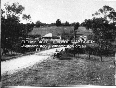
Negative - Photograph, Coghill & Haughton, On the banks of the Plenty, c.1924
Negative copy and associated print of detail from original Sales Brochure: Plenty Township Estate and Bryn Teg Hill's Estate, Coghill & Haughton, Melbourne (c.1924)Roll of 35mm Black and White negative film, 3 strips, (1 of 14 frames) Print 10 x 15 cmFilm - Agfa Ortho 25bridge, bryn teg, bryn teg hill's estate, coghill & haughton, heidelberg golf club hotel, houses, lower plenty, lower plenty bridge, lower plenty road, main road, mrs m thomas, plenty river, plenty township estate, real estate agent, sales brochure -
 Eltham District Historical Society Inc
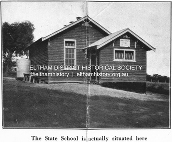
Negative - Photograph, Coghill & Haughton, Original Lower Plenty School, c.1924
Negative copy and associated print of detail from original Sales Brochure: Plenty Township Estate and Bryn Teg Hill's Estate, Coghill & Haughton, Melbourne (c.1924)Roll of 35mm Black and White negative film, 3 strips, (1 of 14 frames) Print 10 x 15 cmFilm - Agfa Ortho 25lower plenty, lower plenty state school no. 1295, bryn teg hill's estate, coghill & haughton, sales brochure -
![Negative - Photograph, Coghill & Haughton, A Beautiful Home on the Plenty [Yallambie, Lower Plenty], c.1924](/media/collectors/4f729f7b97f83e03086018a5/items/62365fb2c8228c0f0d9ff3d8/item-media/6600e1625527135282394551/item-fit-380x285.jpg) Eltham District Historical Society Inc
Eltham District Historical Society IncNegative - Photograph, Coghill & Haughton, A Beautiful Home on the Plenty [Yallambie, Lower Plenty], c.1924
Negative copy and associated print of detail from original Sales Brochure: Plenty Township Estate and Bryn Teg Hill's Estate, Coghill & Haughton, Melbourne (c.1924)Roll of 35mm Black and White negative film, 3 strips, (1 of 14 frames) Print 10 x 15 cmFilm - Agfa Ortho 25bryn teg hill's estate, coghill & haughton, sales brochure, houses, lower plenty, plenty-river, yallambie -
 Eltham District Historical Society Inc
Negative - Photograph, Coghill & Haughton, Old bridge over the Plenty River near Plenty Hotel, c.1924
Negative copy and associated print of detail from original Sales Brochure: Plenty Township Estate and Bryn Teg Hill's Estate, Coghill & Haughton, Melbourne (c.1924)Roll of 35mm Black and White negative film, 3 strips, (1 of 14 frames) Print 10 x 15 cmFilm - Agfa Ortho 25bryn teg hill's estate, coghill & haughton, sales brochure, lower plenty, bridge, hotels, lower-plenty-road, plenty-hotel, plenty-river -
 Eltham District Historical Society Inc
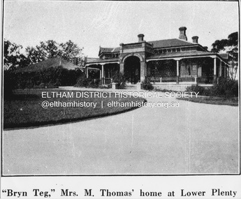
Negative - Photograph, Coghill & Haughton, 'Bryn Teg', Mrs M. Thomas' home at Lower Plenty, c.1924
Negative copy and associated print of detail from original Sales Brochure: Plenty Township Estate and Bryn Teg Hill's Estate, Coghill & Haughton, Melbourne (c.1924)Roll of 35mm Black and White negative film, 3 strips, (1 of 14 frames) Print 10 x 15 cmFilm - Agfa Ortho 25bryn teg hill's estate, coghill & haughton, sales brochure, lower plenty, bryn teg, houses, mrs m thomas, plenty township estate, real estate agent -
 Eltham District Historical Society Inc
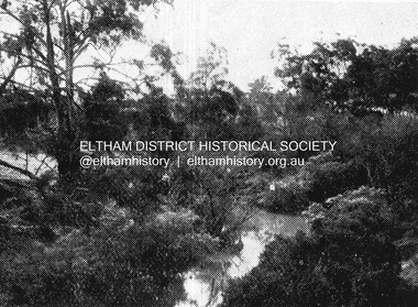
Negative - Photograph, Coghill & Haughton, Plenty River at Lower Plenty, c.1924
Negative copy and associated print of detail from original Sales Brochure: Plenty Township Estate and Bryn Teg Hill's Estate, Coghill & Haughton, Melbourne (c.1924)Roll of 35mm Black and White negative film, 3 strips, (1 of 14 frames) Print 10 x 15 cmFilm - Agfa Ortho 25bryn teg hill's estate, coghill & haughton, sales brochure, lower plenty, plenty river -
 Eltham District Historical Society Inc
Negative - Photograph, Coghill & Haughton, Typical scene on the Plenty River at Lower Plenty, c.1924
Negative copy and associated print of detail from original Sales Brochure: Plenty Township Estate and Bryn Teg Hill's Estate, Coghill & Haughton, Melbourne (c.1924)Roll of 35mm Black and White negative film, 3 strips, (1 of 14 frames) Print 10 x 15 cmFilm - Agfa Ortho 25bryn teg hill's estate, coghill & haughton, sales brochure, lower plenty, plenty river -
 Eltham District Historical Society Inc
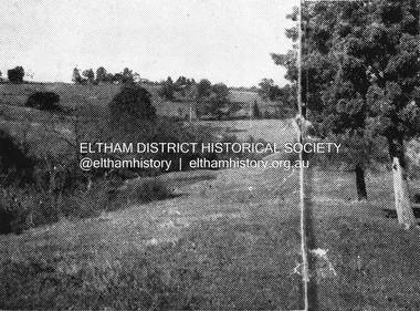
Map, Geoff Braithwaite, Braithwaite ma0p of Eltham circa 1920
A3 photocopy of hand drawn map of Eltham created by Geoff Braithwaite (1914-2008) of his memory of the township about 1920. It includes names of streets and property owners. Folder of information on Geoff Braithwaite Includes A3 photocopy of hand drawn map of Eltham with coloured shading of Eltham in 1920s and 1930sharry gilham collection, eltham, 1920, geoff braithwaite, map, smart family cottage, eltham cemetery, flora caroline braithwaite (nee gamble), geoffrey braithwaite -
 Eltham District Historical Society Inc
Booklet - Folder, Shire of Nillumbik, The Townships of Nillumbik, 1996
Copy of Council brochure "The Townships of Nillumbik" with correspondence from H.G. noting inaccurate information and providing correction. This was an early Nillumbik Shire publication endorsed by the Commissioner Kevin Abbott.5 pagestownships, nillumbik -
 Eltham District Historical Society Inc
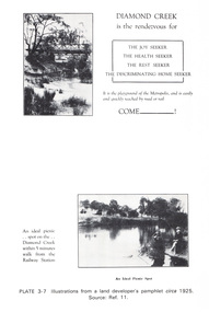
Work on paper (Sub-Item) - Photograph, Illustrations from a land developer's pamphlet promoting Diamond Creek, circa 1925
Photos illustrating the Diamond Creek with a bridge over it and two people sitting by the creek, one is fishing with text describing the kind of person who may like to come to the township. diamond creek, advertising, promotion, land development, real estate -
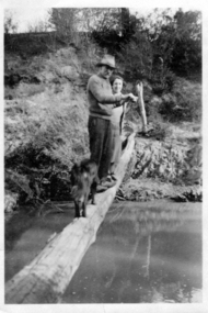 Greensborough Historical Society
Photograph - Digital image, Alan Partington and Teresa Marsh, 1940c
This image shows Alan Partington and Teresa Marsh on a log across the Plenty River at Greensborough. The log was the quickest access to Greensborough township from the Partington home at Willis Vale.Digital copy of black and white photograph.alan partington, teresa marsh, willis vale -
 Kiewa Valley Historical Society
Telephone Directory - Bogong
Bogong township had a small population most of whom had a telephone as they were employees of the SEC. Also listed are the offices and works telephone numbers issued October, 1969Many residents of Bogong had moved to Mt Beauty by 1969 as had some of the offices and works so this list is of interest . It was also when calls went through the exchange(s). The exchanges were based at Mt Beauty (Terminal Station), McKay Creek, Bogong, and Mt Beauty Auto Exchange. Stiff black cardboard cover with metal fastener with 10 pages slightly yellowed. Cover has label 'Telephone' stuck on with sticky tape1st page 7 names added with blue penbogong residents, secv telephone directory, secv offices and works telephones -
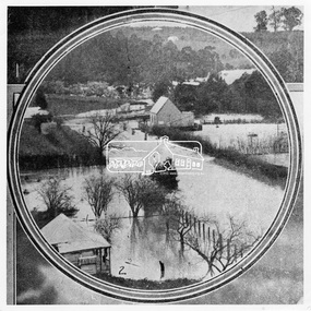 Eltham District Historical Society Inc
Photograph, Leader Publishing Co, Floods at Diamond Creek, Sep. 1924
The Diamond Creek in flood in Diamond Creek township. View north along Diamond Street. The building in the middle distance is the Methodist Church. From "The Leader", 6 September 1924.This photo forms part of a collection of photographs gathered by the Shire of Eltham for their centenary project book, "Pioneers and Painters: 100 years of the Shire of Eltham" by Alan Marshall (1971). The collection of over 500 images is held in partnership between Eltham District Historical Society and Yarra Plenty Regional Library (Eltham Library) and is now formally known as 'The Shire of Eltham Pioneers Photograph Collection.' It is significant in being the first community sourced collection representing the places and people of the Shire's first one hundred years.Digital imageshire of eltham pioneers photograph collection, diamond creek, floods, methodist church, diamond creek (creek), diamond street, 1924 -
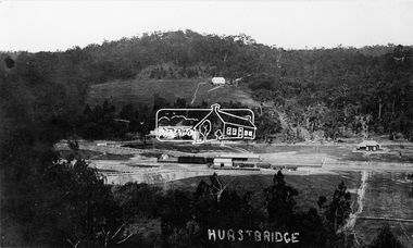 Eltham District Historical Society Inc
Photograph, Hurstbridge - Showing Railway Station
View overlooking the township and surrounding hills of Hurstbridge. The new railway line and station and accompanying works are central. The extension from Eltham to Hurstbridge opened on 2 January 1912.This photo forms part of a collection of photographs gathered by the Shire of Eltham for their centenary project book, "Pioneers and Painters: 100 years of the Shire of Eltham" by Alan Marshall (1971). The collection of over 500 images is held in partnership between Eltham District Historical Society and Yarra Plenty Regional Library (Eltham Library) and is now formally known as 'The Shire of Eltham Pioneers Photograph Collection.' It is significant in being the first community sourced collection representing the places and people of the Shire's first one hundred years.Digital imagesepp, shire of eltham pioneers photograph collection, diamond creek, hurstbridge, railway station, railroad, railway line -
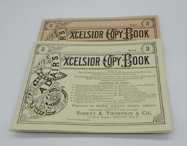 Hume City Civic Collection
Book, Adair's Excelsoir Copy Book
This is a facsimile reproduction published by the Ballarat Historical Park Association, Sovereign Hill Goldmining Township, Ballarat, Victoria 3350, for the use in the Red Hill National School, Sovereign Hill.A cream coloured book with black lettering on the cover. Pages ruled out for copying handwriting.adair, hugh, schools, teaching, nsw department of public education, sovereign hill gold mining township., george evans collection -
 Hume City Civic Collection
Book, Elementary Drawing Copy Book
This is a facsimile of a drawing copy book compiled by an art teacher in london in 1864 and copied by the Ballarat Times, Sovereign Hill Goldmining Township for use at the Red Hill National School.A tan coloured cover with pages set out to enable students to copy different drawings printed at the top of the pages.teaching, primary school, sovereign hill goldmining township, george evans collection -
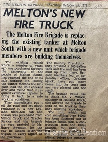 Melton City Libraries
Newspaper, Melton's New Fire Truck, 1973
Ernest W (Bon) Barrie and his brother Edgar built the first Melton Fire Truck. It was housed on the family property until a fire station was constructed in the Melton townshipNewspaper articles about Melton Fire brigadeemergency services -
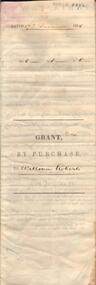 Bendigo Historical Society Inc.
Document - JOHANSON COLLECTION: GRANT BY PURCHASE WILLIAM ROBERTS
Legal document. On front: Dated 17th December 1855. Ac1 R1 P 1. ( acres, roods, perches ) Grant by purchase to William Roberts. In pencil Allot 7 of Sec 12. Inside: 'Victoria - Township Lot. Grantee W. Roberts. Document details purchase of land by above William Roberts of Heathcote, for the sum of two pounds, 12 shillings. Allotment 7, section 12, Township of Heathcote. Land sold as Lot 14. Dated 30 July 1855. Signed by C.W. Hotham ( Sir Charles Hotham ) Property is now 42 Beauchamp Street, Heathcote ( Landata research, 28.3.2017, https://www.landata.vic.gov.au/tpc_confirm_map.aspx?pfi=45257085 )heathcote, land sale, william roberts -
 Eltham District Historical Society Inc
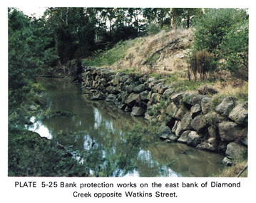
Work on paper (Sub-Item) - Photograph, Bank protection works on the east bank of Diamond Creek opposite Watkins Street
Colour photograph of bank protection works, using bluestone rocks to construct a wall on the east bank of Diamond Creek, to prevent erosion. Opposite Watkins Street, Diamond Creek townshipeltham, drain, diamond creek, erosion, watkins street, protection, bluestone, wall -
 Greensborough Historical Society
Photograph - Digital Image, View from Sondemeyers, 1925c
Photograph shows a view of Greensborough from 'Sondemeyers Hill' located near the corner of St Helena and Diamond Creek Roads. It looks south towards the township of Greensborough. It is a rural scene.Digital copy of black and white photograph.st helena road, diamond creek road, sondemeyers hill, greensborough -
 Greensborough Historical Society
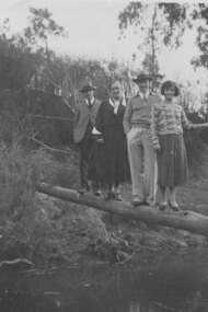
Photograph - Digital image, Alan Partington and others on log to Willis Vale, 1935c
Photograph of Alan Partington (3rd from left) and others crossing the Plenty River at Greensborough. This log over the river was the quickest way to reach the Greensborough township from Willis Vale.A pioneer Greensborough family.Digital copy of black and white photograph.alan partington, willis vale -
 Greensborough Historical Society
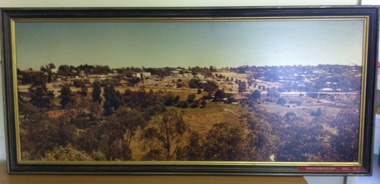
Photograph (Framed), Greensborough December 1977, 1977_12
Photograph two of a series of three panoramic photographs of Greensborough before and after the construction of Greensborough Plaza at the end of the 1970s. Shows the changing landscape of Greensborough from rural to suburban township.These photographs clearly show the change in the street scape of Greensborough from the Hailes Street/Circuit side of town.Panorama photograph in timber frame. One of three in series.Labelled in red on front of frame "Greensborough ... December 1977"greensborough, greensborough plaza -
 Greensborough Historical Society
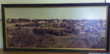
Photograph (Framed), Greensborough in June 1977, 1977_06
Photograph one of a series of three panoramic photographs of Greensborough before and after the construction of Greensborough Plaza at the end of the 1970s. Shows the changing landscape of Greensborough from rural to suburban township.These photographs clearly show the change in the street scape of Greensborough from the Hailes Street/Circuit side of town.Panorama photograph in timber frame. One of three in series. Labelled in red on front of frame 'Greensborough June 1977"greensborough, greensborough plaza