Showing 8377 items matching "bridge"
-
 Eltham District Historical Society Inc
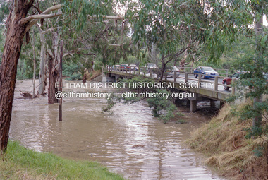
Negative - Photograph, Diamond Creek floodwaters near Main Road Bridge, Eltham, Feb. 2005
Flooding of the Diamond Creek in February 2005Roll of 35mm colour negative film, 7 strips Associated colour print 10 x 15 cmKodak GC400-8bridge, diamond creek (creek), eltham, eltham south, floods, main road, main road bridge -
 Eltham District Historical Society Inc
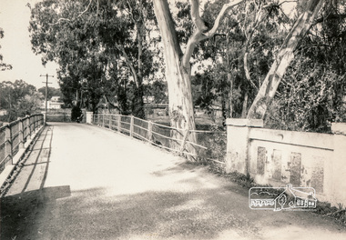
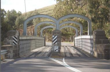
Photograph, Monash Bridge, Hurstbridge-Arthurs Creek Road, Hurstbridge
Black and white photographinfrastructure, shire of eltham infrastructure, bridge, arched bridge, hurstbridge, hurstbridge arthurs creek road, monash bridge -
 Eltham District Historical Society Inc
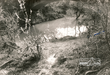
Photograph, Monash Bridge, Hurstbridge-Arthurs Creek Road, Hurstbridge
Black and white photographinfrastructure, shire of eltham infrastructure, bridge, arched bridge, hurstbridge, hurstbridge arthurs creek road, monash bridge -
 Eltham District Historical Society Inc
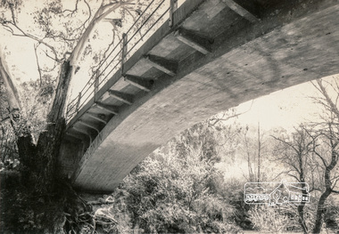
Photograph, Monash Bridge, Hurstbridge-Arthurs Creek Road, Hurstbridge
Black and white photographinfrastructure, shire of eltham infrastructure, bridge, arched bridge, hurstbridge, hurstbridge arthurs creek road, monash bridge -
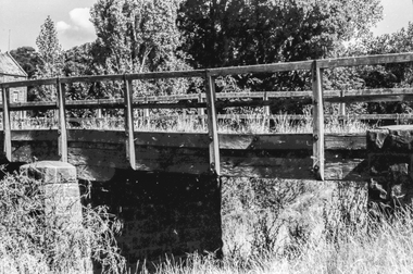 Ballaarat Mechanics' Institute (BMI Ballarat)
Film - Photograph by Herb Richmond. ca 1971, Smeaton - Bridge over the Bullarook Creek (Birch Creek) leading to the old Flour Mill
Ballarat History35mm B&W Kodak Plus X Pan Film.ballarat, ballaraat, smeaton, bridge, bullarook, birch, creek -
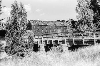 Ballaarat Mechanics' Institute (BMI Ballarat)
Film - Photograph by Herb Richmond. ca 1971, Smeaton- Bridge over the Bullarook Creek (Birch Creek) leading to the old Flour Mill
Ballarat History35mm B&W Kodak Plus X Pan Film.ballarat, ballaraat, smeaton, bridge, bullarook, birch, creek -
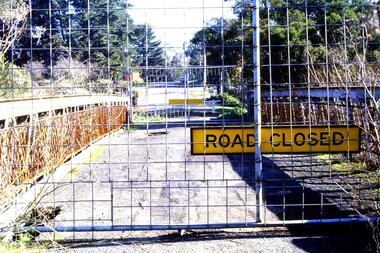 Greensborough Historical Society
Slide - Photograph, John Ramsdale, Old bridge at Lower Plenty under reconstruction: Slide 83, 1990s
Photograph shows a road construction area with "Road Closed" sign and temporary fencing. This is the old bridge at Lower Plenty under reconstruction.Part of the John Ramsdale collection of slides and audio visual material.Colour photograph scanned from slide.No maker's marks. No caption on slide.old lower plenty bridge, lower plenty bridge -
 Greensborough Historical Society
Photograph - Photograph - Digital Image, Main Street bridge Greensborough 1970s, 1970s
A colour photograph of the corner of Para Road and Main Street Greensborough in the 1970s, during the duplication and construction of the bridge over the Plenty River.Digital copy of colour photograph.main street greensborough, para road greensborough, plenty river bridge -
![Newspaper Clipping, Bridge is rail big effort [Rosanna], 11/04/2018](/media/collectors/4f729f5697f83e03086015b8/items/5aed3a8221ea670268548c06/item-media/5b4ad49921ea670f143ddf21/item-fit-380x285.jpg) Greensborough Historical Society
Greensborough Historical SocietyNewspaper Clipping, Bridge is rail big effort [Rosanna], 11/04/2018
The mammoth rail bridge has been installed across Lower Plenty Road in Rosanna by Level Crossing Removal Authority contractors.News article 1 page, black text and colour image .level crossing removal project, rail bridge, lower plenty road rosanna, rosanna station, hurstbridge rail line -
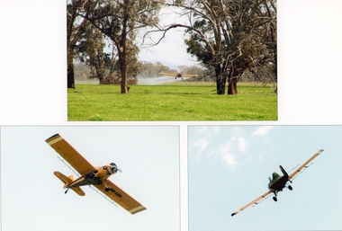 Stawell Historical Society Inc
Photograph, Crop Dusting at Campbell's Bridge
Crop Dusting Ken Hyslop Campbells Bridge. Three colour photographs. Paddock scene with crop dusting airplane. Two of Airplane. -
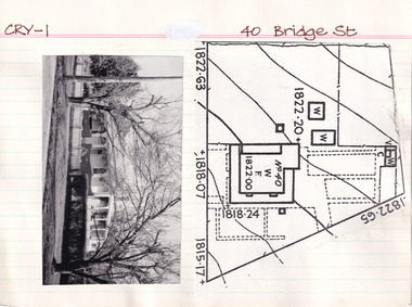 The Beechworth Burke Museum Research Collection
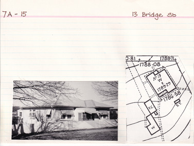
Card (Series) - Index Card, George Tibbits, 40 Bridge Street, Beechworth, 1976
George Tibbits, University of Melbourne. Faculty of Architecture, Building and Town & Regional PlanningIndex system that support the research for Beechworth : historical reconstruction / [by] George Tibbits ... [et al]Arranged by street names of BeechworthEach index card includes: street name and number of property, image of property, allotment and section number, property owners and dates of ownership, description of the property according to rate records, property floor plan with dimensions.beechworth, george tibbitsbeechworth, george tibbits -
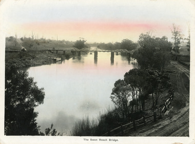 Lakes Entrance Historical Society
Postcard - Bridges, Bulmer, H D, 1915
Colour tinted large format postcard showing lifting bridge over the Tambo River, at Swan Reach, Victoria. Bridge is closed to allow road traffic through. Rough gravel road to Metung on right. Landing on left near bridge. Vegetation on river bank right. Houses in distance on both sides of river.The Swan Reach Bridgeboats and boating, bridges, waterways -
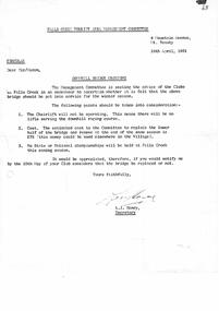 Falls Creek Historical Society
Letter - Circular Downhill Bridge Crossing
Bob (Herman) Hymans (a former member of the Royal Netherlands Navy) was born in Bloemendaal, Holland on 30th September 1922. During World War II he fought against the Japanese in the Dutch East Indies (now Indonesia) and was imprisoned in Changi and on the Burma Railway. After gaining qualifications as a Ski Instructor, Bob arrived in Falls Creek in July 1950. Working as an Instructor and Supervisor at Bogong Lodge, Bob decided his future was in accommodation. He was successful in negotiating an indenture for land from the State Electricity Commission (SEC). It took Bob two years to build his Grand Coeur Chalet but, tragically, it was burned down in August 1961. Bob also built the first Chairlift in Australia. This was a single chairlift and the structure was built from wooden electricity poles. He was constantly full of new ideas and proposals for the village. Bob Hymans died on 7th July 2007. This Collection of documents and letters tells the story of Bob's endeavours to develop Falls Creek into the ski village it is today.This letter is significant because it documents steps taken by the Falls Creek Tourist Area Management Committee to develop and protect the area.A letter dated 12.04.1961. The Management Committee was seeking feedback as to whether the Downhill Bridge Crossing should be put into service during the upcoming winter season. Points to be considered were that the chairlift in the area would not be operating, cost and the fact that no major championships were scheduled.falls creek development, falls creek tourist area management committee -
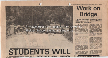 Eltham District Historical Society Inc
Document - Property Binder, Main Road Bridge, Eltham
Newspaper article: Diamond Valley News, 31 January 1984, work to begin on widening of Main Road Bridge over Diamond Creek.main road, bridges, main road bridge, diamond creek, eltham (vic) -
 Eltham District Historical Society Inc
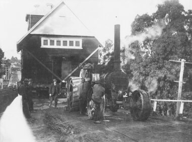
Photograph, Steam locomotive J-500 and goods train crossing the Echuca-Moama Road Rail Bridge, November 1963, 1963
View at guard’s van end of steam train moving over the Echuca Iron Bridge looking north into Moama, New South Wales.Digital TIFF file Scan of 35mm Ilford FP3 black and white negative transparencyechuca-moama road rail bridge, george coop collection, goods train, j-500, j-class steam locomotive (vulcan foundry) -
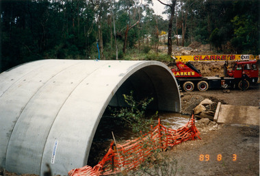 Eltham District Historical Society Inc
Photograph, Bridge construction over the Diamond Creek, Charlber Lane, St Andrews, 3 August 1989, 3 Aug 1989
The first BEBO Arch pre-cast concrete bridge construction in Victoria. A bottle of champagne was dropped to mark the end of this major construction phase.Fifty-three colour photographic printsbebo arch, bridge construction, charlber lane, diamond creek, st andrews -
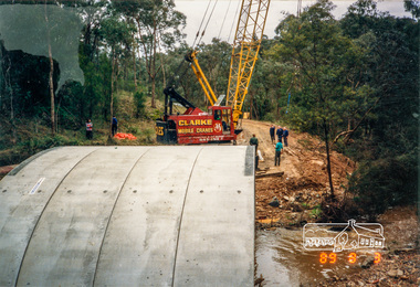 Eltham District Historical Society Inc
Photograph, Bridge construction over the Diamond Creek, Charlber Lane, St Andrews, 3 August 1989, 03/08/1989
A bottle of champagne was dropped to mark the end of this major construction phase. The first BEBO Arch pre-cast concrete bridge construction in Victoria.Colour photographbebo arch, charlber lane, diamond creek, st andrews, bridge construction -
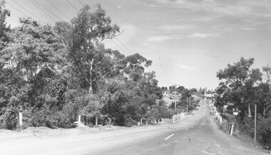
 Eltham District Historical Society Inc
Photograph, Fred Mitchell, Site of the new Eltham Town Park, corner of Main Road and Bridge Street, Eltham, 1968, 1968
During the Main Road duplication. Bridge Street in background to the right of picture. Eltham Town Park was later renamed Alistair Knox Park.Digital copy of colour photographfred mitchell collection, 1968, main road, road construction, duplication, alistair knox park, bridge street, eltham town park -
 Charlton Golden Grains Museum Inc
Photograph, Brownjohn, Reg, Rear of Johnson's Bridge Store c. 2000, c.2000
Derelict rear of building built as Bridge Store in 1872 for Peter Johnson, later Wylie's Building and a furniture store. Photo taken for the Museum.Colour photograph of the rear of an old, brick two storey building. Building appears derelict and disused. Not all the building is in the photo. Old rainwater tank on RH side, part of the roof is missing and the beams are exposed. Gas tank/hot water service in corner in the centre of the photo. Single door to the right of the gas tank and double doors to the left.bridge store, peter johnson, wylie's building, business -
 Stawell Historical Society Inc
Photograph, Mr. Dave Morgan's sheds built from Apple Boxes & Kerosene Tins in Dadswell's Bridge
Series of eight coloured photos featuring sheds made with Apple Packing Boxes and Kerosene Tins at Dave Morgan's place Dadswells Bridge.Series of 8 colour photos of sheds constructed of apple packing boxes and kerosene tins. -
 Ringwood and District Historical Society
Photograph, C of E jambed on bridge over Mullum Creek, W'dyte Rd. Ringwood 1924
Written on back of photograph, "C of E jambed on bridge over Mullum Creek, W'dyte Rd. 1924." Typed below another copy: "Moving Church of England, Ringwood. Stuck on bridge over Mullum Creek in Warrandyte Rd. 1924". Written on backing sheet, "Church of England being moved from C/r Pratt Street and Maroondah H'way to rear post office via Warrandyte Rd., Reynolds Av. and Ringwood Street." -
 Ringwood and District Historical Society
Photograph, Warrandyte Rd. looking towards Maroondah Highway over Mullum Creek bridge - 1966
Typed below photograph, "Warrandyte Rd. looking towards Maroondah Highway - 1966". Backing sheet reads, "Warrandyte Rd. bridge over Mullum Ck. Church of England now on left - 1966". -
 Clunes Museum
Photograph, CIRCA 1960
BLACK AND WHITE PHOTOGRAPH OF JUBILEE BRIDGE.JUBILEE OR QUEENS BRIDGE PRIOR TO 1960local history, photographs, bridges, jubilee bridge -
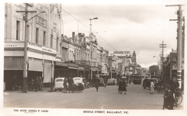 Ballarat Tramway Museum
Postcard, Rose Stereograph Co, "Bridge Street, Ballarat Vic.", late 1930s
The photo shows tram 12 in Bridge St Ballarat on its way to Mt Pleasant. The photo is of Bridge St looking west from Peel St. In the photo are a butcher, a newsagent, a sign "Join ANA Today", along with two ladies with prams crossing the road. Wal Jack on the rear of the photo notes it is about 1940. Based on the cars in the photo, late 1930s. Item 5463 has a poor quality negative of this postcard. Yields information about Bridge St Ballarat during the late 1930sPostcard black and white, divided back, with a handwritten note on rear.See image 2 for details of the handwritten note by Wal Jack on the rear. tramways, trams, bridge st, tram 12 -
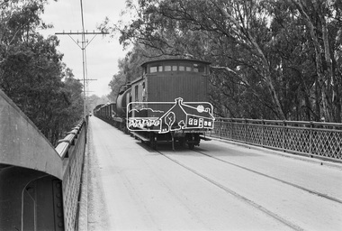
 Eltham District Historical Society Inc
Photograph - Digital Photograph, Alan King, Eltham Railway Trestle Bridge, 28 December 2007
Covered under National Trust of Australia (Victoria) State Significance and Heritage Overlay, Nillumbik Planning Scheme. Published: Nillumbik Now and Then / Marguerite Marshall 2008; photographs Alan King with Marguerite Marshall.; p103 The Eltham railway trestle bridge is the only one of its kind still regularly used in Melbourne’s metropolitan railway network. Opened in 1902, it is also one of Victoria’s very few timber rail bridges that still carries trains.1 The bridge is part of the railway line extension from Heidelberg - extended to Hurstbridge in 1912. This extension resulted in one of the greatest social changes experienced in Eltham Shire, as it considerably lessened its isolation attracting tourists, artists and suburban commuters particularly after World War Two.2 The bridge has been classified by the National Trust as historically, scientifically, aesthetically and socially significant at state level. But this has not always been recognised, and in 1977, locals fought to save it from destruction. The Victorian Railways proposed to replace the bridge with an earth embankment and large culverts to avoid maintenance problems and fire. This was rejected by the Eltham Council who protested that the bridge helped maintain the area’s rural character, historic link and beauty, as well as avoiding possible serious flooding on the flood plain if a culvert was blocked. The bridge stands as part of a National Trust classified landscape which includes the Alistair Knox Park, named after the local conservationist and architect who helped to make Eltham famous for its mud-brick houses. The landscape includes tall and spreading manna gums and candlebarks, and the historic Shillinglaw Cottage. Artist Walter Withers, one of the Heidelberg School of painters, painted the bridge early in the 20th century. The 38 span single-track railway bridge over creek and road has 34 timber-beam spans and four steel-joist spans, supported by four-pile timber piers and timber abutments. It has almost 200m of timber deck. All of the timbers have been replaced over the years, but the only change to the bridge’s character was the addition of pylons and wiring for electric trains in 1923. A petition for a railway to the shire was first made in 1883. A large deputation of local citizens to the Commissioner of Railways proposed a route passing through Alphington to midway between Greensborough and Eltham up the Diamond Creek valley towards Queenstown and Kinglake. As a result the Princes Bridge-Heidelberg Railway was opened in 1888. From 1888 locals demanded a railway extension. Kangaroo Ground farmers in particular, led by Shire Councillor and Member for Evelyn, Ewen Cameron, said it would assist local farmers and orchardists send their produce to the Melbourne market. In 1890, before the severe economic Depression, an extension of the line to Hurst’s Bridge (now Hurstbridge) was included in a new Railways Bill. The parliamentary delegations were regaled with a banquet at Hurst’s barn and entertained by the Diamond Creek Brass Band, but the extension was abandoned when the Depression struck in 1892-1893. The extension of the railway to Eltham, completed in 1902, was one of the few built in those hard times. That is why the Eltham timber-trestle railway bridge is a rare example of a broad-gauge rail bridge constructed between 1893 and 1910. At the opening, despite persistent drizzle, 300 children waving flags and banners were among the large crowd welcoming the first train, carrying official dignitaries, to Eltham. It had taken 24 years to bring the railway to Eltham. From then Eltham became a popular destination for outings. Mr Orford of Eltham recalled that after the railway came to Eltham ‘the craze for picnics on weekends and holidays began…. During the wattle season, wattle trains came to Eltham frequently. The visitors roamed the creek pulling great armfuls of wattle blossom to take back with them to Melbourne’.3 In 1926 the railway line was electrified as part of the metropolitan rail network. But the Victorian Railways decided not to complete the formerly planned Diamond Valley Railway to Queenstown (now St Andrews) and Kinglake.This collection of almost 130 photos about places and people within the Shire of Nillumbik, an urban and rural municipality in Melbourne's north, contributes to an understanding of the history of the Shire. Published in 2008 immediately prior to the Black Saturday bushfires of February 7, 2009, it documents sites that were impacted, and in some cases destroyed by the fires. It includes photographs taken especially for the publication, creating a unique time capsule representing the Shire in the early 21st century. It remains the most recent comprehenesive publication devoted to the Shire's history connecting local residents to the past. nillumbik now and then (marshall-king) collection, eltham railway trestle bridge, eltham trestle bridge -
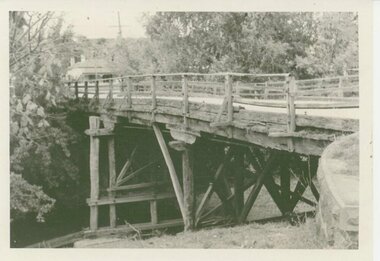
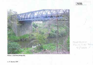 Greensborough Historical Society
Photograph - Photograph (Copy), Anne Paul, Old Plenty Bridge Lower Plenty, 2003_05
Various views of entry into Lot 2A Main Road Lower Plenty, now Edward Willis Drive, including the old Plenty River Bridge.3 colour photographs printed on paper, handwritten or typed captionslower plenty, main road lower plenty, edward willis drive lower plenty, plenty river bridge, plenty river forum -
 Bendigo Historical Society Inc.
Photograph - BENDIGO HISTORICAL SOCIETY COLLECTION: REDESDALE BRIDGE
Colour photograph of the Redesdale bridge over the Campaspe River at Redesdale. The Redesdale Bridge is one of the oldest iron lattice-truss bridges in Victoria, Australia. The Redesdale Bridge is a wrought iron and timber structure with bluestone abutments, located over the Campaspe River near the town of Redesdale. Image taken from Redesdale side of bridge showing two lane design. Plaque on bridge in centre of divided road reads ' Shire of Metcalfe'. Photo taken during a BHS tour, possibly 1990's.bridge -
 Eltham District Historical Society Inc
Photograph, Eltham War Memorial 1914-1918. Cnr. Main Road and Bridge Street, 3 August 1919
Dated 1919, the Eltham Obelisk is decorated with wreaths, most likely for what was originally known as Armistice Day though now known as Remembrance Day, 11 November. The location of the Obelisk at the corner of Bridge Street and Main Road became known as Obelisk Corner and the Bridge Street bridge was also referred to as Obelisk Bridge. The Eltham Obelisk was originally located at the corner of Bridge and Main Roads in 1919. In 1943 (WW2) the local community commenced plans to establish the Eltham War Memorial, a living memorial to benefit the children as opposed to a one in stone as per the obelisk. The Eltham War Memorial Trust was established in 1945. In 1947 the Trust intended for the Obelisk to be relocated from Bridge Street and Main Road to the Garden of Remembrance which was planned as part of the Baby Health Centre which was to be the first of three buildings of the Eltham War Memorial to be built in 1951. In 1951 the Eltham RSL was invited to be represented on the Eltham War Memorial Trust. Around this time, with pending roadworks, the obelisk was relocated to the front garden of the Eltham RSL sub branch on Main Road for safe keeping. In 2007, a suggestion was proposed by Harry Gilham (President, EDHS) to John Cohen (ERSL) to claim a special site along with the historic Shillinglaw trees on the now vacant former Eltham Shire Office site adjacent to the Eltham War Memorial precinct for relocation of the obelisk. In 2010 following the financial collapse and sale of the Eltham RSL Sub-Branch property and amalgamation with the Montmorency Eltham RSL sub-branch, the location of the obelisk was again in immediate jepoardy and in conjunction with Nillumbik Shire Council, the obelisk was relocated in front of the Eltham War Memorial buildings in preparation for the Dawn Service on Anzac Day 2012.This photo forms part of a collection of photographs gathered by the Shire of Eltham for their centenary project book,"Pioneers and Painters: 100 years of the Shire of Eltham" by Alan Marshall (1971). The collection of over 500 images is held in partnership between Eltham District Historical Society and Yarra Plenty Regional Library (Eltham Library) and is now formally known as 'The Shire of Eltham Pioneers Photograph Collection.' It is significant in being the first community sourced collection representing the places and people of the Shire's first one hundred years.Digital image 4 x 5 inch B&W Negsepp, shire of eltham pioneers photograph collection, eltham, main road, bridge street, eltham war memorial, obelisk, obelisk corner, wreath -
 The Beechworth Burke Museum Research Collection
Card (Series) - Index Card, George Tibbits, 13 Bridge Street, Beechworth, 1976
George Tibbits, University of Melbourne. Faculty of Architecture, Building and Town & Regional PlanningIndex system that support the research for Beechworth : historical reconstruction / [by] George Tibbits ... [et al]Arranged by street names of BeechworthEach index card includes: street name and number of property, image of property, allotment and section number, property owners and dates of ownership, description of the property according to rate records, property floor plan with dimensions.beechworth, george tibbitsbeechworth, george tibbits -
 The Beechworth Burke Museum Research Collection
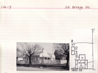
Card (Series) - Index Card, George Tibbits, 24 Bridge Street, Beechworth, 1976
George Tibbits, University of Melbourne. Faculty of Architecture, Building and Town & Regional PlanningIndex system that support the research for Beechworth : historical reconstruction / [by] George Tibbits ... [et al]Arranged by street names of BeechworthEach index card includes: street name and number of property, image of property, allotment and section number, property owners and dates of ownership, description of the property according to rate records, property floor plan with dimensions.beechworth, george tibbitsbeechworth, george tibbits