Showing 1917 items
matching melbourne centenary
-
 Bendigo Historical Society Inc.
Document - FATHER SYDNEY MACEWAN - TENOR, 16 Aug, 1956
The Australian Broadcasting Commission has pleasure in presenting Father Sydney MacEwan (Tenor). Victorian Country Tour 8.15pm. Associate Artist: John Douglas Todd, Pianist. Albury, Regent Theatre, Wed., 25th July. Ballarat, Regent Theatre, Thurs., 2nd Aug. Bendigo, Princess Theatre, Thurs., 16th Aug. Programme One Shilling. Listing of records by Father Sydney MacEwan imported in from England and 2 Australian made records available in local music stores. Father Sydney MacEwan is on his third visit to Australia. The first in 1936 and second in 1948, when he was invited to attend the Centenary of the Roman Catholic Diocese in Melbourne. It was not long after the first trip to Australia, and tours of Canada, the USA and Europe that Sydney MacEwan decided to become a priest, and renounced tempting radio and concert contracts. During the war he was an officiating Chaplin to the RAF Father MacEwan's normal duties as a parish priest . . . John Douglas Todd Tasmanian born in Tasmaniabut lived most of his life in Sydney. As associate artist with father MacEwan, John Douglas Todd, Sydney pianist, is making his sixth tour for the ABC and his second tour with Father MacEwan. He previously toured for the ABC with violinist Jeanne Gautier and singers William Warfield, Lord Lurgan and John Dudley. . . Programme Notes. Australian Broadcasting Commission R J Boyer, E R Dawes, Sir John Medley, The Hon. Dame Enid Lyons, P W Nette, P Vanthoff, C W Anderson, Charles Moses, Conrad Charlton, Dorrie O'Neil. Alceo Galliera conducting the Victoria Symphony Orchestra, Soloist Mervyn Simpson, Trumpet. Coming concert dates Bendigo & Albury. Peter Dawson, Baritone with the Victorian Symphony Orchestra Concert Date. Advertisements for Georges of Collins St., Berlei, Wynvale Wines. Includes photographs of Father Sydney MacEwan & John Douglas Todd. 8 pages plus cover.program, theatre, father sydney macewan, the australian broadcasting commission pesenting father sydney macewan (tenor). victorian country tour associate artist: john douglas todd, pianist. bendigo, princess theatre, thurs., 16th aug. programme one shilling. records by father sydney macewan imported and 2 australian made records available music stores. 3rd visit to australia. 1st in 1936 & 2nd in 1948, centenary of the roman catholic diocese in melbourne. 1st trip to australia, and tours of canada, the usa and europe that sydney macewan decided to become a priest. during the war he was an officiating chaplin to the raf. john douglas todd tasmanian born lived life in sydney. associate artist with father macewan, john douglas todd, sydney pianist, 6th tour for the abc and 2nd tour with father macewan. he toured for the abc with violinist jeanne gautier and william warfield, lord lurgan and john dudley. programme notes. r j boyer, e r dawes, sir john medley, the hon. dame enid lyons, p w nette, p vanthoff, c w anderson, charles moses, conrad charlton, dorrie o'neil. alceo galliera conducting the victoria symphony orchestra, soloist mervyn simpson, trumpet.. peter dawson, baritone with the victorian symphony orchestra georges of collins st., berlei, wynvale wines. photographs of father sydney macewan & john douglas todd. -
 Bendigo Historical Society Inc.
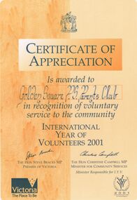
Document - GOLDEN SQUARE PRIMARY SCHOOL COLLECTION: CERTFICATES OF APPRECIATION
42 Certificates of appreciation/participation awarded to Golden Square Primary School Parents' Club, students and teachers. Awards from International Year of Volunteers 2001; Loddon Campaspe Multicultural Services; Bendigo RSL; Indigenous Literacy Foundation; jeans for Genes; Generals Basketball Club; Melbourne City Mission; Anti-Cancer Council; Juvenile Diabetes Research Foundation; MS Readathon, State Schools Relief Committee; Clean up Australia; Family Support Services, Parents Victoria; Good Friday appeal; Victoria Police Historical Society; Jump rope for Heart; Safety House Committee; Starlight foundation; City of Greater Bendigo Olympic Torch Relay; Camp Quality; Zone Football Carnival, School's Garden Awards; Heart Foundation; Target; Scholastic Book Club; School Industry Partnership Project; Royal Flying Doctor Service; Juvenile Diabetes Foundation; McDonald Camp Quality Puppets; Neighbourhood Watch; Centenary of Federation medallion certificate; Derby Hill Camp.bendigo, education, golden square primary school -
 Bendigo Historical Society Inc.
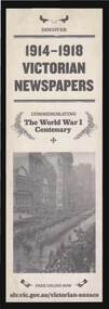
Document - ANZAC: 1914 - 1918 VICTORIAN NEWSPAPER ONLINE
Bookmark, printed with image of soldiers marching down street inner Melbourne, 1914 - 1918. Advertising for free online newspapers at slv.vic.g.v.au/victorian-anzacs. Grey colour background, black print ' 1914 - 1918 Victorian Newspapers, commemorating the World War 1 Centenary'newspaper, anzac, world war 1, newspapers -
 Bendigo Historical Society Inc.
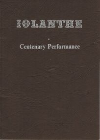
Document - PROGRAMME: CENTENARY PERFORMANCE OF ''IOLANTHE'', MAY 1982, BENDIGO, May 1982
Programme for Centenary Performance of ''Iolanthe'', 23rd April - 8th May 1982, Bendigo; produced by the Gilbert and Sullivan Society of Victoria. Includes synopsis; Music (songs of Act and Act 2; Cast and orchestra details; Production and Programme details; forthcoming productions (Melbourne). Stapled internal pages within light card (oversized) cover.Jenni Cunningham, M. D. Printing & Consultants.entertainment, theatre, bendigo, the gilbert & sullivan society of victoria, centenary performance -
 Bendigo Historical Society Inc.
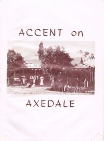
Document - BOOKLET: ACCENT ON AXEDALE
Booklet: ''Accent on Axedale'', published by the Centenary and Back to Axedale Committee 1970. 36 pages with photographs. Chapters on: Early Settlement; Churches; Education; Police; Municipal Affairs; Commerce; Cemeteries; Race Course Reserve; The Railway (O'Keefe); Eppalock Weir; The Hall; The Wars; C.W.A; Camp Sites; C.F.A; Axedale Progress Association; Sport;Alfred Ruskin Publications. Freelance Press, 61-63 City South Melbourne. 3205axedale, history, early settlement, axedale sporting club, indoor bowls, axedale progress association, c.w.a., country fire association.eppalock weir, the railway, race course reserve, cemeteries, axedale farmers club, the pitcher dressers poem by w. g. o'neill, bluestone quarries, threshing teams, hotels, general store and post office. education, churches, early settlement. -
 Bendigo Historical Society Inc.
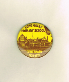
Ephemera - LONG GULLY HISTORY GROUP COLLECTION: LONG GULLY PRIMARY SCHOOL CENTENARY 1879-1979 BADGE
Round yellow and brown metal badge. Long Gully Primary School Centenary 1879-1979 printed on the front with a picture of the school. On the back is a pin and the name Patrick Bros Melbourne.bendigo, history, long gully history group, the long gully history group - long gully primary school centenary 1879-1979 badge, patrick bros melbourne -
 Bendigo Historical Society Inc.
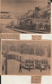
Document - BASIL MILLER COLLECTION: TRAMS - CENTENARY TRAIN - GROUP OF TRAMS
Newspaper clippings - date unknown. R708 leads a second R class locomotive into Bendigo Station. This entourage was known as the 'Centenary Train' and was occupied by members of the Australian Historical Society who travelled from Melbourne. A second photo shows a large group of trams in View Street between Barnard and Rowan Streets. These trams were hired by Australian Railway Historical Society for a tour of Bendigo and district.person, individual, basil miller -
 Bendigo Historical Society Inc.
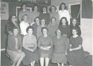
Photograph - FIRE BRIGADE WOMENS AUXILARY, 1961
Photograph - black and white. Photo of Fire Brigade Womens Auxilary. Front - Mrs Boucher, Mrs Bowery, Mrs Hanson, Mrs Browning, Joy Pilcher. Centre - Mrs Nankivell, Mrs Pattison, Mrs Phillips, Mrs Anderson, Mrs Sutherland, Mrs W.Browning, Mrs Box. Back row - Miss Pattison, Fay Pilcher, Mrs Tom Guilmartin, Mrs J.Sutherland, Mrs Luke June. (This is most likely Kangaroo Flat Brigade Womens Auxiliary 1961 - comparable background to Kangaroo Flat Brigade photos of 1961 - names also similar to photo in Kangaroo Flat Centenary Book.) - Julie Hempenstall Sep 2022.The Herald & Weekly Times Ltd. Melbourne.organization, public utility, fire brigade womens auxilary., fire brigade womens auxilary (kangaroo flat?). -
 Bendigo Historical Society Inc.
Book - Merle Bush Trefoil Guild: "Memories of Guiding"
Girl Peace Scouts were formed in Tasmania in 1909 -10. The first meeting of the Girl Guides Association of Australia was held in Melbourne in 1926 by which time all states in Australia had Brownie packs, and Guide and Ranger Companies.Mid blue soft cover book. A Collection of stories celebrating the Centenary of Guiding in Australia 1910 - 2010. Edited by Jill Johnstone and Margaret Taylor. 1st Edition 2009. Printed by Minuteman Press Springvale Victoria. Includes black and white photos.116 pp.girl guides, guiding, history of guiding -
 Bendigo Historical Society Inc.
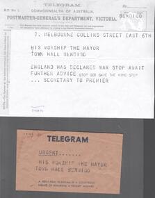
Document - BHS RE-ENACTMENT COLLECTION: TELEGRAM
Brown telegram envelope, on the front: Urgent…..His Worship the Mayor Town Hall Bendigo. Inside a copy of a telegram: 7. Melbourne Collins Street East 6th. His Worship the Mayor Town Hall Bendigo. England has declared war stop await further advice stop God Save the King stop Secretary of the Premier.bendigo, history, centenary of ww1 -
 Bendigo Historical Society Inc.
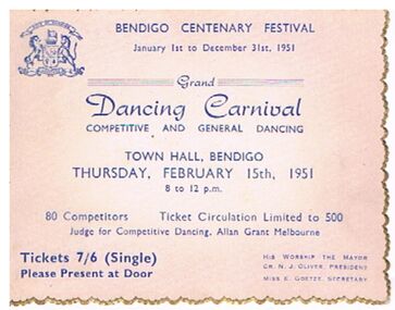
Document - GRAND DANCING CARNIVAL TICKET, BENDIGO 1951, 15/02/1951
Pinkish ticket fading to white in the centre with a gold multi scalloped edge. On card: ' Bendigo Centenary Festival, January 1st to December 31st, 1951. Grand Dancing Carnival competitive and general dancing, Town Hall Bendigo, Thursday, February 15th 1951. Tickets 7/6 single His worship the Mayor, Cr NJ. Oliver President, Miss K Goetze, Secretary' City of Bendigo emblem in the top left corner. Allan Grant of Melbourne, the judge. His worship the Mayor Cr. N. J. Oliver, President and Miss E. Goetze, Secretary. Ticket No 56.entertainment, dance, dance festival, document, grand dancing carnival ticket, cr n j oliver, miss e goetze -
 Bendigo Historical Society Inc.
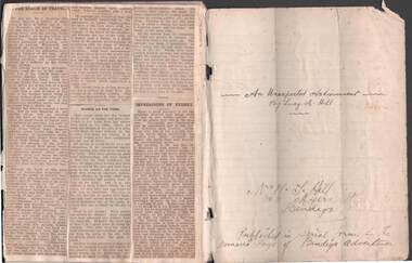
Document - AN UNEXPECTED ACHIEVEMENT: BY LUCY HILL, 2nd February to October 2
See 2804.4//''An Unexpected Achievement'' by Lucy Hill - Cuttings from newspaper (Bendigo Advertiser and published in serial form in the Woman's Page. These articles are multiple ''letters'' from a 'Miss Margaret Holmes' of 'North Plains, Victoria' to a ''Miss Beth Stanhope, Melbourne' .. Dear Beth … (signed Peggy). Some in latter pages from Miss Peggy Holmes to Miss Beth Brownlee!!) Handwritten pencilled list of various words appended at end of extracts. l.Dated February 2 -October 25person, individual, lucy hill, journalist, advertiser, aunt evelyn, the centenary song, gravel hill state school, in the spot light, an unexpected achievement, bendigo. -
 Bendigo Historical Society Inc.
Document - AN UNEXPECTED ACHIEVEMENT: BY LUCY HILL
''An Unexpected Achievement'' by Lucy Hill - Cuttings from newspaper (Bendigo Advertiser and published in serial form in the Woman's Page. These articles are multiple ''letters'' from a 'Miss Margaret Holmes' of 'North Plains, Victoria' to a ''Miss Beth Stanhope, Melbourne' .. Dear Beth … (signed Peggy). Some in latter pages from Miss Peggy Holmes to Miss Beth Brownlee!!) Handwritten pencilled list of various words appended at end of extracts. .Dated February 2 -October 25person, individual, lucy hill, journalist, advertiser, aunt evelyn, the centenary song, gravel hill state school, in the spot light, an unexpected achievement, bendigo. -
Port Melbourne Historical & Preservation Society
Photograph - Centenary Bridge, Port Melbourne, 1990
... Centenary Bridge, Port Melbourne... Centenary Bridge, Port Melbourne ...Part of Ron Laing's collection of photographs taken around Port Melbourne over a thirteen year period. Donated to the PMH&PS by the photographer.Set of five colour photographs of Centenary Bridge at Station Pier prior to demolition.centenary bridge, ron laing -
Port Melbourne Historical & Preservation Society
Photograph - Demolition of Centenary Bridge and reclamation of approach to Station Pier, Port Melbourne, Ron Laing, c. 1993
Part of Ron Laing's collection of photographs taken around Port Melbourne over a thirteen year period. Donated to the PMH&PS by the photographer.A set of thirty-eight colour photographs c1993 covering the demolition and reclamation of the approach to Station Pier after the demolition of Centenary Bridgepiers and wharves - station pier, demolitions, town planning, ron laing -
Port Melbourne Historical & Preservation Society
Photograph - Demolition, various establishments on Port Melbourne foreshore, Ron Laing, 1986 - 1999
Part of Ron Laing's collection of photographs taken around Port Melbourne over a thirteen year period. Donated to the PMH&PS by the photographer.One of 104 colour photographs covering the demolition of all the establishments on the foreshore between Beacon Road and Princes Street (i.e. 'Bayside' site): BP, Engine Works, PMG (Telecom), Seamen's Mission, Centenary Bridge and Princes Street flats, from 1986missions to seamen, industry, manufacturing, centenary bridge, built environment - industrial, demolitions, ron laing, british petroleum oil co, commonwealth engine works, telecom -
Port Melbourne Historical & Preservation Society
Photograph - Various Port Melbourne locations, Jun 1985
Part of Ron LAING's collection of photographs recording Port Melbourne over a thirteen year period. Donated to the PMH&PS by the photographer.Ron LAING photographs .01 - photo taken from a vessel at Station Pier, June 1985. Showing the Port Melbourne foreshore before the old yacht club fire and the building of the high rises. .02 & .03 - photos taken on the corner of Albert and Poolman Streets comparing the scene ten years apart .04 - photo of the Port Melbourne foreshore after demolition of Centenary Bridge, but before the coming of the high rises.built environment - civic, natural environment - beaches and foreshore, piers and wharves - station pier, port melbourne yacht club, pmyc -
Port Melbourne Historical & Preservation Society
Book, Graham Patterson, "Coastal guide to nature and History Port Phillip Bay", 2013
"Coastal guide to nature and History Port Phillip Bay" Book with coloured photograph of rock and coastline on cover.natural environment - beaches and foreshore, natural environment, conservation, piers and wharves - railway pier, piers and wharves - station pier, piers and wharves - princes pier, coastal, port phillip bay, centenary bridge, beacons, robert harper & co ltd, liardet family -
Port Melbourne Historical & Preservation Society
Document - Menu, Centenary Dinner, J Kitchen & Sons, Jul 1956
Menu for Centenary dinner for J Kitchen and Sons (1856-1956) held at the Hotel Australia, Melbourne on July 10 1956.industry - manufacturing, business and traders - soaps/candles, celebrations fetes and exhibitions, j kitchen & sons pty ltd, f b (ford) kitchen, f n shepherd - chairman of directors, w d phillips - managing director -
Port Melbourne Historical & Preservation Society
Photograph - Ford Kitchen cutting the cake, Centenary Dinner, J Kitchen & Sons, Jul 1956
Photograph taken at Centenary Dinner for J KItchen and Sons (1856-1956) with the celebration cake being cut by Mr F B Kitchen (Ford) - see also 3396.07industry - manufacturing, business and traders - soaps/candles, celebrations fetes and exhibitions, j kitchen & sons pty ltd, f b (ford) kitchen, f n shepherd - chairman of directors, w d phillips - managing director -
Port Melbourne Historical & Preservation Society
Document - Letterhead, facsimile, Liardet Centenary Committee
Facsimile of Liardet Centenary Committee letterhead, made for the 175th exhibition November 2014, from a scrap of photocopy of the original (facsimile incorrectly made to A4 size)celebrations fetes and exhibitions, liardet family, local government - city of port melbourne, henry melville fennell, william howe, sydney sims anderson, j p burke, joe nield, wilbraham frederick evelyn liardet, wfe liardet, pamela horsley -
Port Melbourne Historical & Preservation Society
Document, ANZAC 2014-2018 - Centenary. Sharing Victoria's stories and Making connections, 19 Oct 2014
Collected by Ann Gibson at the event on Sunday October 19, 2014 at Princes Pier, Port Melbourne. The commemoration of the departure of the World War I first convoy 1914.'ANZAC 2014-2018 - Centenary. Sharing Victoria's stories and Making connections" Folder entitled "Their journey is our story"war - world war i, piers and wharves - princes pier, celebrations fetes and exhibitions, armed services - army, armed services - navy, anzac centenary, city of port phillip, victorian government, world war i first convoy -
Port Melbourne Historical & Preservation Society
Document, ANZAC 2014-2018 - Centenary. Sharing Victoria's stories and Making connections, 19 Oct 2014
Collected by Ann Gibson at the event on Sunday October 19, 2014 at Princes Pier, Port Melbourne. The commemoration of the departure of the World War I first convoy 1914.'ANZAC 2014-2018 - Centenary. Sharing Victoria's stories and Making connections" 1919 children's Peace Medal on card (Facsimile)war - world war i, piers and wharves - princes pier, celebrations fetes and exhibitions, armed services - army, armed services - navy, children, anzac centenary, city of port phillip, victorian government, world war i first convoy, children's peace medal -
Port Melbourne Historical & Preservation Society
Document, ANZAC 2014-2018 - Centenary. Sharing Victoria's stories and Making connections, 19 Oct 2014
Collected by Ann Gibson at the event on Sunday October 19, 2014 at Princes Pier, Port Melbourne. The commemoration of the departure of the World War I first convoy 1914.ANZAC 2014-2018 - Centenary. Sharing Victoria's stories and Making connections" "Commemoration of the departure of the WWI First Convoy 1914" programwar - world war i, piers and wharves - princes pier, celebrations fetes and exhibitions, armed services - army, armed services - navy, anzac centenary, city of port phillip, victorian government, world war i first convoy -
Port Melbourne Historical & Preservation Society
Document, ANZAC 2014-2018 - Centenary. Sharing Victoria's stories and Making connections, 19 Oct 2014
Collected by Ann Gibson at the event on Sunday October 19, 2014 at Princes Pier, Port Melbourne. The commemoration of the departure of the World War I first convoy 1914.'ANZAC 2014-2018 - Centenary. Sharing Victoria's stories and Making connections" Victorian Government Veteran Affairs Grants - brochurewar - world war i, piers and wharves - princes pier, celebrations fetes and exhibitions, armed services - army, armed services - navy, anzac centenary, city of port phillip, victorian government, world war i first convoy -
Port Melbourne Historical & Preservation Society
Document, ANZAC 2014-2018 - Centenary. Sharing Victoria's stories and Making connections, 19 Oct 2014
Collected by Ann Gibson at the event on Sunday October 19, 2014 at Princes Pier, Port Melbourne. The commemoration of the departure of the World War I first convoy 1914.'ANZAC 2014-2018 - Centenary. Sharing Victoria's stories and Making connections" Messages from the Premier, Denis Napthine; Minister for Veteran's Affairs, Damien Drum; Chair of the Victorian ANZAC Committee.war - world war i, piers and wharves - princes pier, celebrations fetes and exhibitions, armed services - army, armed services - navy, anzac centenary, city of port phillip, victorian government, world war i first convoy, denis napthine, damien drum -
Port Melbourne Historical & Preservation Society
Document, ANZAC 2014-2018 - Centenary. Sharing Victoria's stories and Making connections, 19 Oct 2014
Collected by Ann Gibson at the event on Sunday October 19, 2014 at Princes Pier, Port Melbourne. The commemoration of the departure of the World War I first convoy 1914.ANZAC 2014-2018 - Centenary. Sharing Victoria's stories and Making connections" "World War I History - Victoria's story" bookletwar - world war i, piers and wharves - princes pier, celebrations fetes and exhibitions, armed services - army, armed services - navy, anzac centenary, city of port phillip, victorian government, world war i first convoy -
Port Melbourne Historical & Preservation Society
Document, ANZAC 2014-2018 - Centenary. Sharing Victoria's stories and Making connections, 19 Oct 2014
Collected by Ann Gibson at the event on Sunday October 19, 2014 at Princes Pier, Port Melbourne. The commemoration of the departure of the World War I first convoy 1914.'ANZAC 2014-2018 - Centenary. Sharing Victoria's stories and Making connections" "Victoria's World War One Legacy - Recipients of the Victoria Cross" - bookletwar - world war i, piers and wharves - princes pier, celebrations fetes and exhibitions, armed services - army, armed services - navy, anzac centenary, city of port phillip, victorian government, world war i first convoy, victoria cross -
Port Melbourne Historical & Preservation Society
Document, ANZAC 2014-2018 - Centenary. Sharing Victoria's stories and Making connections, 19 Oct 2014
Collected by Ann Gibson at the event on Sunday October 19, 2014 at Princes Pier, Port Melbourne. The commemoration of the departure of the World War I first convoy 1914.'ANZAC 2014-2018 - Centenary. Sharing Victoria's stories and Making connections" "Community Resource Guide " - Bookletwar - world war i, piers and wharves - princes pier, celebrations fetes and exhibitions, armed services - army, armed services - navy, anzac centenary, city of port phillip, victorian government, world war i first convoy -
Port Melbourne Historical & Preservation Society
Document, ANZAC 2014-2018 - Centenary. Sharing Victoria's stories and Making connections, 19 Oct 2014
Collected by Ann Gibson at the event on Sunday October 19, 2014 at Princes Pier, Port Melbourne. The commemoration of the departure of the World War I first convoy 1914.'ANZAC 2014-2018 - Centenary. Sharing Victoria's stories and Making connections" a second 1919 Children's Peace Medal from another set of documents . Collected to be kept in Numismatics box.war - world war i, piers and wharves - princes pier, celebrations fetes and exhibitions, armed services - army, armed services - navy, anzac centenary, city of port phillip, victorian government, world war i first convoy