Showing 6940 items matching "view street"
-
 Eltham District Historical Society Inc
Photograph, Beard Street, Eltham, 3 Sep 1981
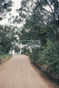
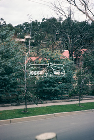
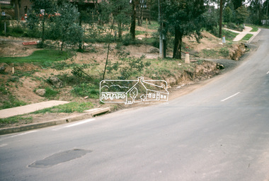
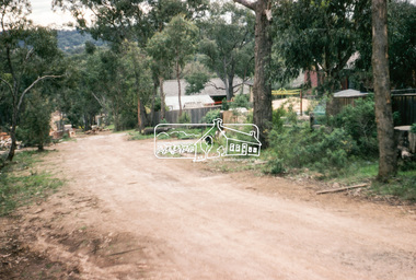
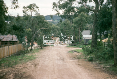
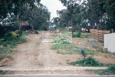
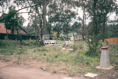
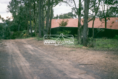
... to footpaths and gutters and general views of Beard Street... to footpaths and gutters and general views of Beard Street ...Roll of film taken by Eltham Shire Council officers of roads and houses in the Eltham East area, 3 September 1981 prior to construction of new water main; including views of existing damage to footpaths and gutters and general views of Beard Street. These images provide a perspective of housing estate developments and changes in housing styles and road development which began sweeping in from the mid 1970s with increasing urbanisation of what was once more outlying suburbs and regions.35mm colour positive transparency (1 of 28) Mount - Kodak Kodachrome Cardeltham, infrastructure, roads, beard street -
 Eltham District Historical Society Inc
Photograph, Beard Street, Eltham, 3 Sep 1981
... to footpaths and gutters and general views of Beard Street... to footpaths and gutters and general views of Beard Street ...Roll of film taken by Eltham Shire Council officers of roads and houses in the Eltham East area, 3 September 1981 prior to construction of new water main; including views of existing damage to footpaths and gutters and general views of Beard Street. These images provide a perspective of housing estate developments and changes in housing styles and road development which began sweeping in from the mid 1970s with increasing urbanisation of what was once more outlying suburbs and regions.35mm colour positive transparency (1 of 28) Mount - Kodak Kodachrome Cardeltham, infrastructure, roads, beard street, frank street -
 Eltham District Historical Society Inc
Photograph, Beard Street, Eltham, 3 Sep 1981
... to footpaths and gutters and general views of Beard Street... to footpaths and gutters and general views of Beard Street ...Roll of film taken by Eltham Shire Council officers of roads and houses in the Eltham East area, 3 September 1981 prior to construction of new water main; including views of existing damage to footpaths and gutters and general views of Beard Street. These images provide a perspective of housing estate developments and changes in housing styles and road development which began sweeping in from the mid 1970s with increasing urbanisation of what was once more outlying suburbs and regions.35mm colour positive transparency (1 of 28) Mount - Kodak Kodachrome Cardeltham, infrastructure, roads, beard street, grove street, valonia drive, wycliffe crescent, livingstone road -
 Eltham District Historical Society Inc
Photograph, Beard Street, Eltham, 3 Sep 1981
... to footpaths and gutters and general views of Beard Street... to footpaths and gutters and general views of Beard Street ...Roll of film taken by Eltham Shire Council officers of roads and houses in the Eltham East area, 3 September 1981 prior to construction of new water main; including views of existing damage to footpaths and gutters and general views of Beard Street. These images provide a perspective of housing estate developments and changes in housing styles and road development which began sweeping in from the mid 1970s with increasing urbanisation of what was once more outlying suburbs and regions.35mm colour positive transparency (1 of 28) Mount - Kodak Kodachrome Cardeltham, infrastructure, roads, beard street -
 Eltham District Historical Society Inc
Photograph, Beard Street, Eltham, 3 Sep 1981
... to footpaths and gutters and general views of Beard Street... to footpaths and gutters and general views of Beard Street ...Roll of film taken by Eltham Shire Council officers of roads and houses in the Eltham East area, 3 September 1981 prior to construction of new water main; including views of existing damage to footpaths and gutters and general views of Beard Street. These images provide a perspective of housing estate developments and changes in housing styles and road development which began sweeping in from the mid 1970s with increasing urbanisation of what was once more outlying suburbs and regions.35mm colour positive transparency (1 of 28) Mount - Kodak Kodachrome Cardeltham, infrastructure, roads, beard street -
 Eltham District Historical Society Inc
Photograph, Water Main Pipe Track (Madine Way-Bainbridge Drive), Eltham, 3 Sep 1981
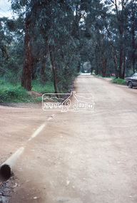
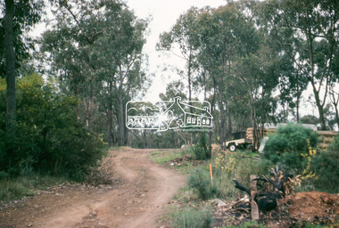
... to footpaths and gutters and general views of Beard Street... to footpaths and gutters and general views of Beard Street ...Roll of film taken by Eltham Shire Council officers of roads and houses in the Eltham East area, 3 September 1981 prior to construction of new water main; including views of existing damage to footpaths and gutters and general views of Beard Street. These images provide a perspective of housing estate developments and changes in housing styles and road development which began sweeping in from the mid 1970s with increasing urbanisation of what was once more outlying suburbs and regions.35mm colour positive transparency (1 of 28) Mount - Kodak Kodachrome Cardeltham, infrastructure, roads, bainbridge drive linear reserve, madine way, water main pipe track -
 Eltham District Historical Society Inc
Photograph, Water Main Pipe Track (Madine Way-Bainbridge Drive), Eltham, 3 Sep 1981
... to footpaths and gutters and general views of Beard Street... to footpaths and gutters and general views of Beard Street ...Roll of film taken by Eltham Shire Council officers of roads and houses in the Eltham East area, 3 September 1981 prior to construction of new water main; including views of existing damage to footpaths and gutters and general views of Beard Street. These images provide a perspective of housing estate developments and changes in housing styles and road development which began sweeping in from the mid 1970s with increasing urbanisation of what was once more outlying suburbs and regions.35mm colour positive transparency (1 of 28) Mount - Kodak Kodachrome Cardeltham, infrastructure, roads, bainbridge drive linear reserve, madine way, water main pipe track -
 Eltham District Historical Society Inc
Photograph, Water Main Pipe Track (Madine Way-Eucalyptus Road), Eltham, 3 Sep 1981
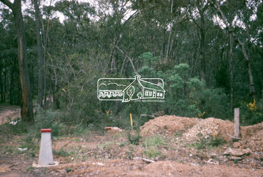
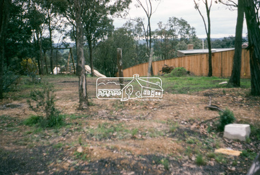
... to footpaths and gutters and general views of Beard Street... to footpaths and gutters and general views of Beard Street ...Roll of film taken by Eltham Shire Council officers of roads and houses in the Eltham East area, 3 September 1981 prior to construction of new water main; including views of existing damage to footpaths and gutters and general views of Beard Street. These images provide a perspective of housing estate developments and changes in housing styles and road development which began sweeping in from the mid 1970s with increasing urbanisation of what was once more outlying suburbs and regions.35mm colour positive transparency (1 of 28) Mount - Kodak Kodachrome Cardeltham, infrastructure, roads, water main pipe track, madine way, eucalyptus road, tadema park -
 Eltham District Historical Society Inc
Photograph, Water Main Pipe Track (Madine Way-Eucalyptus Road), Eltham, 3 Sep 1981
... to footpaths and gutters and general views of Beard Street... to footpaths and gutters and general views of Beard Street ...Roll of film taken by Eltham Shire Council officers of roads and houses in the Eltham East area, 3 September 1981 prior to construction of new water main; including views of existing damage to footpaths and gutters and general views of Beard Street. These images provide a perspective of housing estate developments and changes in housing styles and road development which began sweeping in from the mid 1970s with increasing urbanisation of what was once more outlying suburbs and regions.35mm colour positive transparency (1 of 28) Mount - Kodak Kodachrome Cardeltham, infrastructure, roads, water main pipe track, madine way, eucalyptus road, tadema park -
 Bendigo Historical Society Inc.
Photograph - FIVE LIONS HOTEL: BENDIGO, 1950/60's
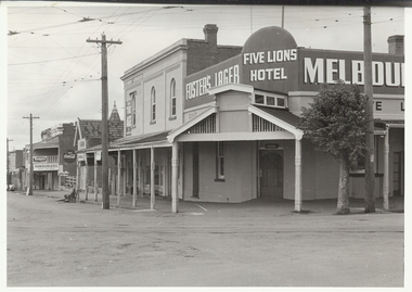
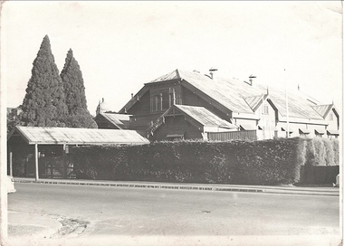
... Hotel,Cnr View and Barnard Streets, Bendigo. Tram lines... Inc. History House 11 Mackenzie Street Bendigo goldfields ...Black and white photograph. Not mounted. Five Lions Hotel,Cnr View and Barnard Streets, Bendigo. Tram lines with overhead cables. 2 men on seat on left of photo. Fosters Lager sign on left with Five Lions Hotel over corner. 2 double storey shops, one next to hotel appears empty, faint name of business ??/ pastrycook. On back ' Five Lions Hotel, cnr. Barnard and View Sts. 'Alan Doney ??organization, business, five lions hotel -
 Whitehorse Historical Society Inc.
Artwork, other - Ink Line Drawing, 26 Highview Gve., Burwood E, 1994
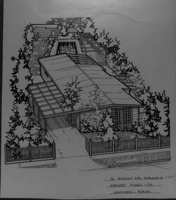
... view from the street of a weatherboard house and carport.... An angled birds eye view from the street of a weatherboard house ...A property illustration by Margaret Picken Commissioned by the real estate agency Fletchers Real Estate for the purpose of advertising 26 Highview Gve., Burwood in 1994 Made by using Rotring ‘Rapidigraph’ drafting pens with Rotring ink on Rapidigraph polyester drafting film, double matte. This property is listed as having sold for $160,250 in 1994 Since being sold the land has been redeveloped, with nothing remaining of the house depicted in this drawing. Trained as a cartographic draftsman within the mining industry, Margaret Picken is an artist who worked producing property illustrations for real estate agencies in eastern suburbs of Victoria from 1983-2005. Retiring from the industry as technological changes favored coloured photography over illustrations, and commissioning companies over sole contractors.This artwork is of Historical Significance as a record of local domestic architecture.A black ink line drawing on drafters film by Margaret Picken, of 26 Highview Gve., Burwood East. An angled birds eye view from the street of a weatherboard house and carport. Extending to the backyards with pool, pagoda, and shed in the background. There are two hole punch holes on near the left edge. There are some crinkles in the paper near the top centre of the work. There is a two centimetre long mark along the centre top edge.26 Highview Gve., Burwood E Margaret Picken -94 Woodards B/Burnwhitehorse historical society, schwerkolt cottage, housing, architecture, margaret picken, burwood, house, garden -
 Port Melbourne Historical & Preservation Society
Photograph - Port Melbourne, Pat Grainger, 1996
... toward city of Nott Street and the school .02 View toward city... taken c1996 .01 View toward city of Nott Street and the school ...Four panoramic black&white photos taken c1996 .01 View toward city of Nott Street and the school .02 View toward city of Nott Street, vertical .03 Pedestrian crossing in front of the 1910 post office .04 View north of Bay Street footpath, west sidebuilt environment, nott street, bay street -
 Bendigo Historical Society Inc.
Document - Connelly,Tatchell, Dunlop, Smalley and Balmer Image, January 1925
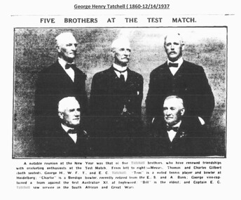
... as a solicitor in 1883 at Albion Chambers, View Street. By 1887 he had... as a solicitor in 1883 at Albion Chambers, View Street. By 1887 he had ...Thomas Jefferson Connelly (1858-18/10/1892) Son of Thomas James Connelly a well known JP at Inglewood. Admitted as a solicitor in the Supreme Court in 1880. Started own business as a solicitor in 1883 at Albion Chambers, View Street. By 1887 he had joined with George Henry Tatchell and in 1889 they moved their firm to Williamson Street. On 8th Jan 1885 he was elected to the Bendigo Council and was elected as Mayor 16th Aug 1887. He was the first Bendigo born Mayor and the youngest. He served on the committee of the Bendigo hospital and the Mechanics Institute and was a prominent member of the ANA. He was also a Captain of a local militia force. He married Frances Cresswell Reynolds and they had 3 children who were very young when they were left fatherless in 1892. Thomas died in Kerang, following an epileptic fit. He was attending a case at the time. He is buried at the Bendigo Public Cemetery. George Henry Tatchell was the son of Thomas Tatchell JP of Inglewood. He was admitted as an attorney by the Supreme Court in 1887 and formed a partnership with Thomas Jefferson Connelly 22/9/1887. By 1894, their practice had been joined by Adam George Dunlop. In 1904 he was elected president of the Bendigo Bar Association. George was a very bowler and was part of an Australian team that travelled to Britain in 1930, where he won the Veteran Pairs Competition competing with his brother William. He retired to “Woodford”, Toorak. Adam George Dunlop (1864 – 28/2/1921) Son of Andrew McBride Dunlop. He married Marion Ethel Nicholls, a widow in 1905. Admitted as a solicitor, proctor and conveyancer in 1892. When Thomas Connelly died, his will stated that his share in the law firm was to be sold and if it was sold to Dunlop, he would have 3 years to pay for. This clearly happened and by 1894 the firm was known as Connelly, Tatchell and Dunlop.He continued to work for the firm Tatchell, Dunlop, Smalley and Balmer for 25 years and retired several months before his death, to “Milltara”, Glyndon Ave., Brighton. He was heavily involved in the Sandhurst Mechanics Institute and served as president in 1899 and 1901. He was treasurer of the Zenith Lodge of Masons in 1907. He was president of the ANA in 1896 and president of the Bendigo Law Association in 1907. Whilst in Bendigo, the family lived in “Millewa”, Kangaroo Flat. Jonathon Smalley (1873-21/8/1961) Son of Peter, a mining investor and his wife Ellen. 1899 married Catherine Horsemann Manning with whom he had four children. Jonathon proved proficient in sign language when he stepped into a court case where the defendant was hearing impaired. In 1904 he was the president of the Eaglehawk Mechanics Institute. Other community postings included Vice President of Bendigo Football Association (1909), President Bendigo ANA (1899), Councilor for Eaglehawk Borough (1904- ), elected Mayor of Eaglehawk (1909),and President of Bendigo Law Association (1910). Jonathon and his wife resided at “Overton”, View Street, Bendigo (now Harry Little Childcare Centre). Jonathon was a champion Lawn bowler, winning the Country Singles Championship in 1913. He is buried at the Bendigo Cemetery. Sydney Raeburn Balmer (1869 – 24/11/1938) Sydney was the son of Robert and Elizabeth Balmer. He married Catherine HAswell McDonald in 1905 and they later lived in Lily Street, Bendigo. After qualifying as a barrister and solicitor, he was initially employed as a barrister for Mr Cussen (later a judge) for 2 years. He then spent 9 years working in Melbourne before joining the firm to be thenceforth known as Tatchell, Dunlop, Smalley and Balmer from 31sdt Dec. 1909 Black and White newspaper photograph of five Tatchell Brothers attending a cricket match. Undated on clipping. Clipping taken from 'The Argus, Wednesday 7th January, 1925, page 9, 'Five Brothers at the Test Match'.solicitors, councillors, connelly, t.j. connelly -
 Federation University Historical Collection
Photograph - Photograph - Black and White, Ballarat School of Mines Buildings, Albert Street, c1970
... , Albert Street .2) View of Carpentry Building looking towards...) Ballarat School of Mines Building, Albert Street .2) View ...Kenneth Joynson Flecknoe joined the Ballarat School of Mines Council in 1979 becoming its 11th President in 1981. He joined the Ballarat Courier newspaper in 1953 as company secretary, becoming General Manager in 1966. Flecknoe joined the board of directors in 1968 and was managing director from 1969 until his retirement in 1987. Flecknoe was chairman of the Ballarat Broadcasters Pty Ltd (3BA), of the gateway Publishing Company which published newspapers in Ararat and Stawell and of the Ballarat Publishing Company which published Ballarat News, and was formerly deputy chairman of associated Broadcasting Services Ltd (BTV6 Ballarat and GMV Shepparton). He was also Chairman of the advisory board of Ballarat's St John of God Hospital. Flecknoe's contribution to the Royal South Street Society, of which he was a past president, and a committee member since 1961, was rewarded with life membership. He was also a life member of the Ballarat Historical Park Association (Sovereign Hill). The Ballarat School of Mines building in Albert Street was named "Flecknoe" in 1991, three years after Flecknoe's death.Three photographs showing a Ballarat School of Mines building on Albert Street. .1) Ballarat School of Mines Building, Albert Street .2) View of Carpentry Building looking towards Albert Street .3) Building on the Ballarat School of Mines Building (Possibly the former caretaker's cottage), near Albert Streetballarat school of mines, albert street, flecknoe, carpentry, vocational skills, ken flecknoe, flecknoe building -
 Rutherglen Historical Society
Post Card, various
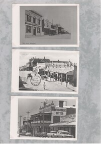
... on a sheet of decorative grey paper. Top one is a view of Main... paper. Top one is a view of Main Street, Rutherglen, looking ...Three black and white photographs of old postcards, mounted on a sheet of decorative grey paper. Top one is a view of Main Street, Rutherglen, looking west, featuring Younkman's Store and the Victoria Hotel. Middle one is also of Main Street, looking west, featuring the Star Hotel at the corner of High Street, with horses and carts in the street. Bottom one is of the Victoria Hotel in Main Street, with cars of 1970s vintage parked along the street.Centre photo has an upside down post mark: "Sydney | Jan 5 | 12 [illeg.] | 1909 | 75"main street, high street, star hotel, victoria hotel, s younkman & co -
 Kew Historical Society Inc
Photograph - Kew Recreation Hall, Wellington Street, c.1950
... Front view, from Wellington Street, of the former Kew...." Front view, from Wellington Street, of the former Kew Recreation ...The Kew Recreation Hall was opened in 1880. For eighty years it was a major venue for concerts, performances, dances and civic events. It was demolished in 1960.This work forms part of the collection assembled by the historian Dorothy Rogers (1905-1973), donated to the Kew Historical Society by her son in 2015. The manuscripts, photographs, maps, and documents were sourced by her from both family and local collections or produced as references for her print publications. Many were directly used by Rogers in writing ‘Lovely Old Homes of Kew’ (1961) and 'A History of Kew' (1973), or the numerous articles on local history that she produced for suburban newspapers. Most of the photographs in the collection include detailed annotations in her hand. The Rogers Collection provides a comprehensive insight into the working habits of a historian from the 1960s to the 1970s. Front view, from Wellington Street, of the former Kew Recreation Hall. The 1880 weatherboard building has a long covered entrance leading to the gabled facade. A smaller gabled room protrudes from one side of the facade. At this stage, the decorative features: gables, brackets, finials, etc were still preserved. The triple window would have been a major source of light for the interior. It appears to have an upper balcony in front of the window. Annotation verso: "28. Kew Recreation Hall prior to demolition. Built about 1880."dorothy rogers, kew recreation hall, buildings -- wellington street (kew) -
 Kew Historical Society Inc
Photograph - Kew Recreation Hall, Wellington Street, c.1950
... Oblique view, from Wellington Street, of the former Kew... in 1960". Oblique view, from Wellington Street, of the former Kew ...The Kew Recreation Hall was opened in 1880. For eighty years it was a major venue for concerts, performances, dances and civic events. It was demolished in 1960.This work forms part of the collection assembled by the historian Dorothy Rogers (1905-1973), donated to the Kew Historical Society by her son in 2015. The manuscripts, photographs, maps, and documents were sourced by her from both family and local collections or produced as references for her print publications. Many were directly used by Rogers in writing ‘Lovely Old Homes of Kew’ (1961) and 'A History of Kew' (1973), or the numerous articles on local history that she produced for suburban newspapers. Most of the photographs in the collection include detailed annotations in her hand. The Rogers Collection provides a comprehensive insight into the working habits of a historian from the 1960s to the 1970s. Oblique view, from Wellington Street, of the former Kew Recreation Hall. The 1880 weatherboard building has a long covered entrance leading to the gabled facade. A smaller gabled room protrudes from one side of the facade. At this stage, the decorative features: gables, brackets, finials, etc were still preserved. The triple window would have been a major source of light for the interior. It appears to have an upper balcony in front of the window. Annotation verso: "Kew Recreation Hall. Built ca. 1880 (Photo prior to demolition in 1960".dorothy rogers, kew recreation hall, buildings -- wellington street (kew) -
 Mt Dandenong & District Historical Society Inc.
Photograph, Main Street, Olinda, c1930s
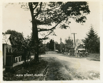
... Street Olinda. View is looking NW from Olinda Monbulk Road... Street Olinda. View is looking NW from Olinda Monbulk Road ...Number 10 in commercial seriesSmall photograph, number 10 in Olinda series, showing Main Street Olinda. View is looking NW from Olinda Monbulk Road towards Range Road. Left hand building is old Olinda Post Office. Ice truck is outside shops in distance and a delivery truck with tarp can be seen. c1930solinda, post office, truck -
 Ballarat Tramway Museum
Photograph - Digital image, Late 1950's
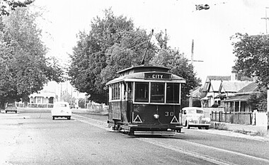
... lighting. Has the houses either side of the street in view... canopy lighting. Has the houses either side of the street in view ...Yields information the appearance and details about SEC Tram No. 30 in the 1950's in bound along Ripon St on the View Point Line.Digital scan from the Ben Parle collection of SEC No. 30 in Ripon St, in bound to the City of the View Point line. Photo 1950's or early 1960 prior to introduction of dash canopy lighting. Has the houses either side of the street in view. Photo received with the Ben Parle slides 09/2004. trams, tramways, ripon st, view point, tram 30 -
 Ballarat Tramway Museum
Photograph - Digital image, Late 1950's
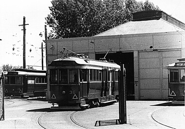
... lighting. Has the houses either side of the street in view... the houses either side of the street in view. Photo received ...Yields information the appearance and details about the depot and trams 20 and 36 in the late 1950's.Digital scan from the Ben Parle collection of SEC No. 36 on No. 2 road at the depot and No. 20 on 0 road at the depot. Photo 1950's or early 1960 prior to introduction of dash canopy lighting. Has the houses either side of the street in view. Photo received with the Ben Parle slides 09/2004. trams, tramways, depot, tram 20, tram 36 -
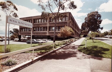 Vision Australia
Photograph - Image, Royal Blind Society of New South Wales in Enfield
... South Wales building in Enfield, as viewed from Mitchell Street... Wales building in Enfield, as viewed from Mitchell Street ...Colour photograph taken of the Royal Blind Society of New South Wales building in Enfield, as viewed from Mitchell Street. The two storey building has a car park underneath, with a separate external car park in the front of the building and a sloping driveway and footpath up to the covered entrance. To the right of the driveway is a short term visitors park. Gum trees are planted amongst a well kept lawn. Image was taken around the later 1970s-mid 1980s. A "Royal Blind Society' sign points up the driveway.Digital Image of Enfield building taken from Mitchell Streetroyal blind society of new south wales, buildings -
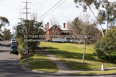 Eltham District Historical Society Inc
Photograph, Peter Pidgeon, Eltham Primary School, Dalton Street, Eltham, 2 Aug. 2022
... View looking up Dalton Street from near Main Road where... melbourne View looking up Dalton Street from near Main Road where ...View looking up Dalton Street from near Main Road where the former pond was situated. The pond was drained by Council in 1932 due to concerns of mosquitoes, etc against the wishes of long standing residents such as Thekla Jarrold (39 years) and John Clark (22 years). On the right is the Eltham Primary Schoool No. 209 with the former Headmaster's residence.Born Digitaleltham, dalton street, main road, eltham primary school, headmaster's residence, state school no. 209 -
 Clunes Museum
Photograph, C. NETTLETON, GOVERNMENT BRIDGE, CLUNES, SOUTH WEST
... PHOTOGRAPH, - VIEW TAKEN FROM GEORGE STREET SHOWING... GOVERNMENT BRIDGE CLUNES. SOUTH WEST PHOTOGRAPH, - VIEW TAKEN FROM ...PHOTOGRAPH, - VIEW TAKEN FROM GEORGE STREET SHOWING LANDSCAPE, GOVERNMENT BRIDGE - LOOKING SOUTH WEST. .1 SEPIA PHOTOGRAPH MOUNTED ON CARDBOARD .2 SEPIA PHOTO PRINT .3 BLACK AND WHITE PHOTO PRINT .4 SMALL BLACK AND WHITE PHOTO PRINT .5 SMALL BLACK AND WHITE PHOTO PRINT GOVERNMENT BRIDGE CLUNES. SOUTH WESTlocal history, photography, photographs, bridges and buildings -
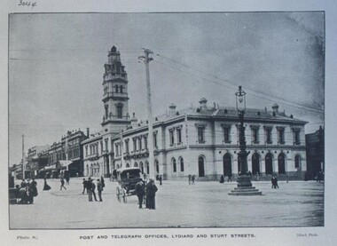 Federation University Historical Collection
Photograph - Photograph - Black and White, Ballarat Post and Telegraph Office - 1897, 1897
... Ballarat Post Office - view north along Lydiard Street from... widow's walk Ballarat Post Office Ballarat Post Office - view ...Early photograph of the Ballarat Post Office taken from the intersection of Sturt and Lydiard Streets. A gas lamp stands in the middle of the intersection. People standing and talking on the roads. The Post Office was built in two sections. Section one built in 1864. Section two and the tower were built in 1885. It was built in the Victorian Italianate design. Arched headed windows on the ground floor originally formed a colonnade. These were filled in to provide more internal space. The tower was a feature - the top having a cast iron balustraded widow's walk.Ballarat Post Office - view north along Lydiard Street from its intersection with Sturt Street. Image taken in 1897. Gas lamp in the middle of the intersection. Numerous people are seen standing in the middle of the road talking. There are wires noticeable but cannot verify if they are electric or for the telephone. Electricity was produced in Dana Street Ballarat as early as 1895post office, gas lamp, overhead wires, tower, arched headed windows, victorian italianate design, widow's walk, ballarat post office