Showing 64278 items
matching house
-
 City of Ballarat Libraries
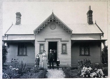
Photograph - Card Box Photographs, Garden Gate-Keepers North Lodge, Ballarat circa 1915
This was the first house built in Gregory Street opposite Colpin Ave. The picture shows Lucinda & William Usebach with granddaughters Muriel (Giles) Edna Brown(Newman).gregory street, lucinda usebach, william usebach, building, gardens, persons, private dwelling, costume -
 Lakes Entrance Historical Society
Photograph, Lakes Post Newspaper, 1994
William Durley's wife had a confectionary shop, they were the parents-in-law of Alexander Murray businessman, sawmiller and builder of Kia Ora House Lakes EntranceBlack and white photograph of headstone of William Durley an early resident of area, in Garden Cemetery Lakes Entrance Victoriacemeteries, associations -
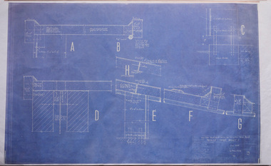 Robin Boyd Foundation
Drawing - Architectural, Robin Boyd, 290 Walsh Street, South Yarra, Jun-58
Project: House for Mr and Mrs Robin Boyd drawn by Robin Boyd of Grounds Romberg & Boyd. Details-Refer Sheet 8, Drawing Sheet no. 9Working Drawing, Colour Photocopy -
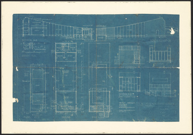 Robin Boyd Foundation
Drawing - Architectural, Robin Boyd, 290 Walsh Street South Yarra, 1958
Project: House for Mr and Mrs Robin Boyd, 290 Walsh Street South Yarra drawn by Robin Boyd of Robin Boyd, Grounds Romberg & Boyd.Working Drawing, Blueprint -
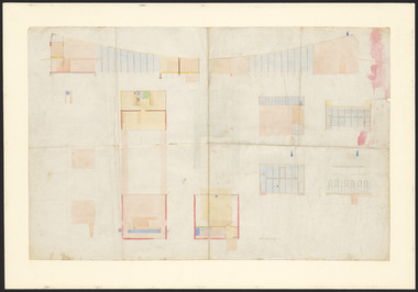 Robin Boyd Foundation
Drawing - Architectural, Robin Boyd, 290 Walsh Street South Yarra, 1958
Project: House for Mr and Mrs Robin Boyd, 290 Walsh Street South Yarra drawn by Robin Boyd of Robin Boyd, Grounds Romberg & Boyd.Working Drawing, Colour copy, very faded. -
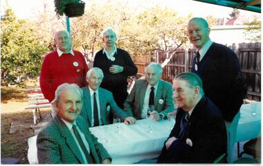 Melbourne Legacy
Photograph - Photo, Legatees
Photos of a social gathering of Legatees in the garden of a house. Names and date unknown. Legatees supported each other by coming together for various events throughout the year. A record of the social benefits of Legatees.Colour photo x 6 of Legatees enjoying a social gathering.legatee event, comradeship -
![Toast 25-5-1986 [Hallatrow]](/media/collectors/550653872162f11fb04854aa/items/5e3037ba21ea6717786eae87/item-media/5e3038b121ea6717786f92e1/item-fit-380x285.jpg) Kew Historical Society Inc
Kew Historical Society IncDocument, Toast 25-5-1986 [Hallatrow], 1986
Hallatrow is located at 6 Holroyd Street Kew. It was the home of Thomas Brodribb. The notes were written by his descendant and recall his family's occupation of the house.A manuscript, written by Jim Brodribb, the grandson of Thomas Brodribb, the original owner of Hallatrow, recalling his family's years at Hallatrow (now 6 Holroyd Street in Studley Park.) hallatrow - 6 holroyd street - kew )vic), historic buidlings - studley park - kew (vic) -
University of Melbourne, Burnley Campus Archives
Photograph - Black and white print, 395/31A
"Original residence of Curator of Egg-Laying Competition. Spindly tree close to house is Eucalyptus citriodora planted by Mrs. Macauley's mother Mrs. Roberts." THKcurator, egg laying, competition, eucalyptus, mrs. macauley, mrs. roberts, e. m. gibson collection -
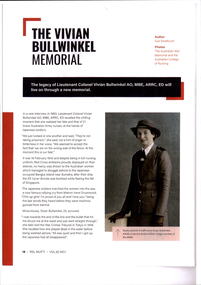 Melbourne Legacy
Article, The Vivian Bulwinkel Memorial, 2022
An article in Mufti magazine about Vivian Bulwinkel and a planned memorial to her at the AWM. The wellness centre opened in Legacy House in 2021 is named in her honour.The article mentions the Legacy/RSL Veterans Hub at Legacy House.Colour photocopy x 4 pages of an article in Mufti Vol 62 April 2022 about Vivian Bulwinkel.vivian bullwinkel, memorial -
The 5th/6th Battalion Royal Victoria Regiment Historical Collection
Magazine - Framed Magazine Cover, Anzac Bulletin No. 64. London March 29, 1918, March 29 1918
Issued to members of the Australian Military and Naval Forces in Great Britain France and elsewhere. Published by the authority of the High Commissioner for Australian, Australia House, London, W.C.Framed copy of the front cover of the " Anzac Bulletin" issue No. 64. London March 29, 1918. On this cover is a sketch of an Australian soldier in a slouch hat with side up turned holding a SMLE with bayonet affixed leaning on a circular picture of two diggers " boiling a billy in the Trenches. At the base of the page is an ad for Kiwi shoe polish.ww1, wark vc club, print media, anzac bulletin -
 Melton City Libraries
Photograph, Myers family at Burnbank, Unknown
Named after Burnbank St Ballarat by Martha Myers1909. Demolished 1969 due to compulsory order after Martha moved to her house in McKenzie st.Myers family members at the Burnbank propertylocal identities -
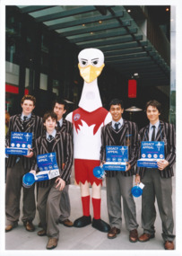 Melbourne Legacy
Photograph - Photo, Legacy Appeal 2004, Selling Badges, September 2004
Photos during Badge Week in September 2004. Badge sellers in school uniform outside Legacy house with President George MacKenzie and with the Sydney Swans mascot. A record of the fundraising for the Legacy Appeal in 2004.Colour photo x 2 of badge sellers in school uniform in Badge week.Printed on the back "legacy appeal, fundraising, badge week -
Clunes Museum
Book - DIARY, LETTS SON & CO
DIARY WAS FOUND IN A HOUSE IN QUEENSLAND 40 YEARS AGO , BY MR.& MRS. HAY. ON MAY 20TH 2007, WAS DONATED TO THE CLUNES MUSEUM AT "CLUNES BOOKTOWN FOR A DAY"BROWN HARDCOVERED DIARY OF JOHN HOARE-SMITH, ENGINEER, SURVEYOR OR SECRETARY OF THE BOROUGH OF CLUNES.LETTS'S NO 9 DIARY 1865local history, documents, borough of clunes, diary -
 Clunes Museum
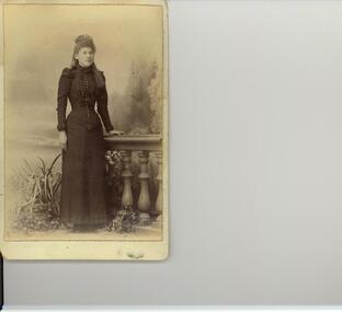
Photograph, BAWDEN PHOTOGRAPHER
PHOTOGRAPH FOUND IN THE HOME OF THE LATE LAURA HUDSON , HOUSE IN LOWER STREET, CLUNES.[ NOW BLACKMORE ROAD] THIS HOME WAS LATER OWNED BY MR. G. WILTSHIRE.PHOTOGRAPH OF YOUNG WOMEN [NAME UNKNOWN] WEARING DRESS WITH WHITE SKIRT, DARK BODICE AND HEM LINE; WHITE FRILL AT NECK LINE.local history, photography, photographs, hudson, laura. -
 Bendigo Military Museum
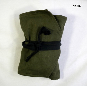
Equipment - SEWING KIT, C. 1962- 1970
Commonly called "House wife kit". Issued to Wayne Forbes 3176337 1Field Sqd RAE. Refer Cat No 754 for service history also 2586.Sewing kit - khaki green , Folded with 2 pockets ,1 with brown button fastening and black cord tie made of fabric. personal effects - sewing kit, military equipment, house wife -
 Warrnambool and District Historical Society Inc.
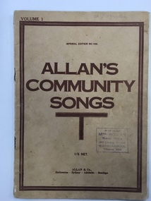
Booklet, Allan's Community Songs, 1920s
This is a book of music produced by Allan & Co. English- born George Allan (1826-1897) was a pioneer singing teacher in Melbourne who joined the music warehouse of Wilkie and Webster in 1862 and became the sole proprietor in 1874. By the late 1870s Allan & Co was the largest music warehouse in the Southern Hemisphere. It was bought by Brashs Stores in 1998 and since then it has had a series of other owners operating on a limited scale. Allan & Co. had a music warehouse in Warrnambool later in the 20th century. The supplier of this music item in Warrnambool was Mrs Fanny Rowan (nee Lavery) who had a music store at 143 Liebig Street after 1918. Later, in the 1930s, she had a music and stationery shop in the Oddfellows Hall and, as the owner of the building, also operated the Plaza Cinema in that building. This item is of some interest mainly because it was sold by Mrs Fanny Rowan, a prominent Warrnambool businesswoman in the first half of the 20th century. It is also of interest because it is an example of the music produced by Allan and Co, at one time the largest supplier of music books in Australia. Also Warrnambool had for some time an Allans Music Store at 76 Liebig Street. This is a soft-cover book of 50 pages containing the music of well-known community songs. The pages were stapled but the staples have been removed and there are rust marks and some tearing where the staples were removed. The book has a buff-coloured cover with brown printed material on the back and front covers. The back contains a list of the music titles in another booklet, ‘Primary Melodies’. The front cover has a stamp of the music shop of Mrs Rowan of Liebig street, Warrnambool and there is a brown border of two lines on the front cover. The inside first page has a list of contents. Front Cover: ‘Volume One, Imperial Edition No. 164, Allan’s Community Songs, 1/6 net, Allan & Co., Melbourne, Sydney, Adelaide, Bendigo’. Front Cover in pencil: ‘A.L.Brodie’ Stamp: ‘ From Mrs Rowan, Music House, 143 Liebig Street, Warrnambool, Phone 634.’ allan & co, allans store,, warrnambool, fanny rowan music store, history -
 Ringwood and District Historical Society
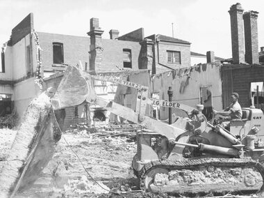
Photograph, Maroondah Highway Central, Ringwood. Demolition of Coffee Palace, Main St. 1966
Black and white photograph (2 copies- 1 large, 1 small)Typed below large photograph: "Demolition of Coffee Palace - Main St. 1966". Written on back of smaller duplicate photograph: "Demolishing Coffee Palace & shops cnr. Maroondah Hwy. & Adelaide St. (west cnr.) 1966. Portion of house on right - This was home of T. Grant, Blacksmith, 1883". -
Whitehorse Historical Society Inc.
Document, Robert Collier Land, 1903
50 acres and house in Canterbury Road Blackburn to I.N. Cuttle for (pounds)590Papers relating to land dealings by Robert Collier of Springvale Road Tunstall. 50 acres and house in Canterbury Road Blackburn to I.N. Cuttle for (pounds)590collier, robert, t.r.b morton & coghill, maddock & jamison, canterbury road blackburn, freehold investment company of australia ltd -
 Kew Historical Society Inc
Plan, Melbourne & Metropolitan Board of Works : Borough of Kew : Detail Plan No.1574, 1905
The Melbourne and Metropolitan Board of Works (MMBW) plans were produced from the 1890s to the 1950s. They were crucial to the design and development of Melbourne's sewerage and drainage system. The plans, at a scale of 40 feet to 1 inch (1:480), provide a detailed historical record of Melbourne streetscapes and environmental features. Each plan covers one or two street blocks (roughly six streets), showing details of buildings, including garden layouts and ownership boundaries, and features such as laneways, drains, bridges, parks, municipal boundaries and other prominent landmarks as they existed at the time each plan was produced. (Source: State Library of Victoria)This plan forms part of a large group of MMBW plans and maps that was donated to the Society by the Mr Poulter, City Engineer of the City of Kew in 1989. Within this collection, thirty-five hand-coloured plans, backed with linen, are of statewide significance as they include annotations that provide details of construction materials used in buildings in the first decade of the 20th century as well as additional information about land ownership and usage. The copies in the Public Record Office Victoria and the State Library of Victoria are monochrome versions which do not denote building materials so that the maps in this collection are invaluable and unique tools for researchers and heritage consultants. A number of the plans are not held in the collection of the State Library of Victoria so they have the additional attribute of rarity.Original survey plan, issued by the MMBW to a contractor with responsibility for constructing sewers in the area identified on the plan within the Borough of Kew. The plan was at some stage hand-coloured, possibly by the contractor, but more likely by officers working in the Engineering Department of the Borough and later Town, then City of Kew. The hand-coloured sections of buildings on the plan were used to denote masonry or brick constructions (pink), weatherboard constructions (yellow), and public buildings (grey). This plan shows several very large houses, particularly along Glenferrie Road, and the area now occupied by Ruyton Girls’ School. ‘Tarring’ (incorrectly spelled here as ‘Karring’) was built for Henry Henty in 1872, on part of his original allotment of 20 acres, and ‘Mount View’, which retains its original building and the fountain in the front garden, is part of Ruyton’s Junior School. The most significant change to Tarring and its grounds since 1903, involve the removal of a number of the outbuildings, including a Burmese temple, bought by Henty from the Burmese Exhibit at the Great Exhibition of 1880. It is shown on the plan as a summerhouse. The two-storey mansion, on the corner of Glenferrie Road and Wellington Street, was built in 1891 by leading architect Alfred White as his own home. Having an initial N.A.V. of £160, the house was purchased by a warehouseman Henry Lister, by 1900, when the N.A.V. was recorded at £111. By the turn of the century the house was known as ‘Comaques’. By contrast, much smaller houses are shown in Scott and Byron Streets, including a tiny Mission Hall in Byron Street, which belonged to the Anglican Church from at least 1903 to 1917.melbourne and metropolitan board of works, detail plans, maps - borough of kew, mmbw 1574, cartography -
 Eltham District Historical Society Inc
Photograph, 218 Pitt Street, Eltham, c.1985, 1985c
House was rented by Kim Tarpey between October 1983 and June 1985. It was one of the buildings originally part of Birds Orchard. Harold Bird was her landlord, a retired primary school teacher who, when she knew him was driving the mobile library bus. Her partner had him as a teacher at Montmorency Primary in grade 4. The house was next door to what is now a bushland reserve near the Pauline Toner Reserve. It was on the corner of Pitt and Arthur St - the driveway was near the roundabout and went off to the right of the driveway that now belongings to 220 Pitt street and which was bushland at the time. It was sold in 1985 and consequently demolished, a large house has replaced it. It was situated approximately where the front door of No. 218 is nowadays with the facade roughly in line with the now garage wall to the left of this front door.Digital file only - scanned from personal photo album on loan (27 images) List of images EDHS_04644-1.tif Kitchen window looking towards Eucalyptus Road, 218 Pitt Street, Eltham, c.1985 EDHS_04644-2.tif 218 Pitt Street, Eltham, c.1985 EDHS_04644-3.tif 218 Pitt Street, Eltham, c.1985 EDHS_04644-4.tif Kitchen looking towards Pitt Street Reserve, 218 Pitt Street, Eltham, c.1985 EDHS_04644-5.tif 218 Pitt Street, Eltham, c.1985 EDHS_04644-6.tif Bathroom walkway/laundry, 218 Pitt Street, Eltham, c.1985 EDHS_04644-7.tif 218 Pitt Street, Eltham, c.1985 EDHS_04644-8.tif 218 Pitt Street, Eltham, c.1985 EDHS_04644-9.tif 218 Pitt Street, Eltham, c.1985 EDHS_04644-10.tif 218 Pitt Street, Eltham, c.1985 EDHS_04644-11.tif 218 Pitt Street, Eltham, c.1985 EDHS_04644-12.tif 218 Pitt Street, Eltham, c.1985 EDHS_04644-13.tif 218 Pitt Street, Eltham, c.1985 EDHS_04644-14.tif 218 Pitt Street, Eltham, c.1985 EDHS_04644-15.tif 218 Pitt Street, Eltham, c.1985 EDHS_04644-16.tif 218 Pitt Street, Eltham, c.1985 EDHS_04644-17.tif Lounge window looking towards Mount Pleasant Road, 218 Pitt Street, Eltham, c.1985 EDHS_04644-18.tif Fire place in lounge, 218 Pitt Street, Eltham, c.1985 EDHS_04644-19.tif Fire place in lounge, 218 Pitt Street, Eltham, c.1985 EDHS_04644-20.tif View from lounge room window looking towards corner of Eucalyptus and Mount Pleasant roads, 218 Pitt Street, Eltham, c.1985 EDHS_04644-21.tif View from lounge room window looking towards corner of Eucalyptus and Mount Pleasant roads, 218 Pitt Street, Eltham, c.1985 EDHS_04644-22.tif View from lounge room looking towards Pitt Street and Wattle Grove, 218 Pitt Street, Eltham, c.1985 EDHS_04644-23.tif View from lounge room looking towards Pitt Street and Wattle Grove, 218 Pitt Street, Eltham, c.1985 EDHS_04644-24.tif 218 Pitt Street, Eltham, c.1985 EDHS_04644-25.tif Back garden showing previous tank stumps. There was a hole in the wall where a possum got through, 218 Pitt Street, Eltham, c.1985 EDHS_04644-26.tif View from back fence looking towards Pitt Street and Wattle Grove, 218 Pitt Street, Eltham, c.1985 EDHS_04644-27.tif View from back fence on to Eucalyptus Road. Pitt Street Reserve to the right, 18 Pitt Street, Eltham, c.1985218 pitt street, eltham, houses, birds orchard, harold bird, kim tarpey, eucalyptus road -
 Eltham District Historical Society Inc
Photograph, View from lounge room looking towards Pitt Street and Wattle Grove, 218 Pitt Street, Eltham, c.1985, 1985c
House was rented by Kim Tarpey between October 1983 and June 1985. It was one of the buildings originally part of Birds Orchard. Harold Bird was her landlord, a retired primary school teacher who, when she knew him was driving the mobile library bus. Her partner had him as a teacher at Montmorency Primary in grade 4. The house was next door to what is now a bushland reserve near the Pauline Toner Reserve. It was on the corner of Pitt and Arthur St - the driveway was near the roundabout and went off to the right of the driveway that now belongings to 220 Pitt street and which was bushland at the time. It was sold in 1985 and consequently demolished, a large house has replaced it. It was situated approximately where the front door of No. 218 is nowadays with the facade roughly in line with the now garage wall to the left of this front door.Digital file only - scanned from personal photo album on loan218 pitt street, eltham, houses, birds orchard, harold bird, kim tarpey, eucalyptus road -
 Eltham District Historical Society Inc
Photograph, View from back fence looking towards Pitt Street and Wattle Grove, 218 Pitt Street, Eltham, c.1985, 1985c
House was rented by Kim Tarpey between October 1983 and June 1985. It was one of the buildings originally part of Birds Orchard. Harold Bird was her landlord, a retired primary school teacher who, when she knew him was driving the mobile library bus. Her partner had him as a teacher at Montmorency Primary in grade 4. The house was next door to what is now a bushland reserve near the Pauline Toner Reserve. It was on the corner of Pitt and Arthur St - the driveway was near the roundabout and went off to the right of the driveway that now belongings to 220 Pitt street and which was bushland at the time. It was sold in 1985 and consequently demolished, a large house has replaced it. It was situated approximately where the front door of No. 218 is nowadays with the facade roughly in line with the now garage wall to the left of this front door.Digital file only - scanned from personal photo album on loan218 pitt street, eltham, houses, birds orchard, harold bird, kim tarpey, eucalyptus road -
 Eltham District Historical Society Inc
Photograph, View from back fence on to Eucalyptus Road. Pitt Street Reserve to the right, 18 Pitt Street, Eltham, c.1985, 1985c
House was rented by Kim Tarpey between October 1983 and June 1985. It was one of the buildings originally part of Birds Orchard. Harold Bird was her landlord, a retired primary school teacher who, when she knew him was driving the mobile library bus. Her partner had him as a teacher at Montmorency Primary in grade 4. The house was next door to what is now a bushland reserve near the Pauline Toner Reserve. It was on the corner of Pitt and Arthur St - the driveway was near the roundabout and went off to the right of the driveway that now belongings to 220 Pitt street and which was bushland at the time. It was sold in 1985 and consequently demolished, a large house has replaced it. It was situated approximately where the front door of No. 218 is nowadays with the facade roughly in line with the now garage wall to the left of this front door.Digital file only - scanned from personal photo album on loan218 pitt street, eltham, houses, birds orchard, harold bird, kim tarpey, eucalyptus road -
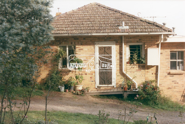
![Photograph - Digital image, Willis Vale [2], 1950c](/media/collectors/4f729f5697f83e03086015b8/items/54fd41442162f10d30bf885f/item-media/54fd41912162f10d30bf8caa/item-fit-380x285.jpg) Greensborough Historical Society
Greensborough Historical SocietyPhotograph - Digital image, Willis Vale [2], 1950c
View of Greensborough in the distance from Willis Vale and surrounding land: House built by Edward Maygar, The flowering Hawthorne Bushes were planted by William Partington. Note the prominent house on upper right where Robert Whatmough lived in the mid 19th century and later sold to Partington family. It was located on the Plenty River across from Partington's Flat. The derelict Willis Vale house was destroyed in 1964 when a fire originating from North Plenty Gorge - Kurrak Road - was lit by two teenage boys and made its way several kilometres down to Partington's Flat Greensborough. In 1946, Alan Partington built the Alwyn Farmhouse in place of the original Robert Whatmough home seen in this photo which became Whatmough Park circa 1976.Home of the Partington familyDigital copy of black and white photograph.willis vale, partington family, maygar family, whatmough -
 Robin Boyd Foundation
Article, Robin Boyd, Breaking point in Sydney, Apr-66
Robin Boyd was asked to write this article, after Jorn Utzon resigned for the Sydney Opera House commission. Description of the tension between Utzon requiring more freedom to develop his ideas, and the pressure applied by Davis Hughes, State Minister of Public Works of NSW Government. Boyd describes the controversy, the outblowing of costs. Robin Boyd’s desk cupboard contained two exercise books (item D482.1-D482.2) and assorted articles, essays and other material regarding the building of the Sydney Opera House, inserted inside the front cover of Walkabout magazine, July 1966 (item P1377). This publication is one of those inserts. Many of these were collected by Boyd’s eldest daughter, Mandie, who recalls that her father was writing a book, but was very disillusioned with the way the entire Opera House saga unfolded. A reprint from The Architectural Forum pp 21-22.Also p23-24, pp 81-84.A reprint from The Architectural Forum, p21.sydney opera house, utzon, davis hughes, arne jacobsen, saarinen, arup, edward herbert farmer, sydney opera house project, walsh st library -
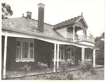
 Kew Historical Society Inc
Photograph - Lalla Rookh : 41 Fellows Street, Progress Press, 1978
The National Trust (Victoria) citation on the Heritage Victoria Database describes Lalla Rookh as charming and rare example of a substantial domestic building from the depths of the depression of the 1890s. It was Classified by the Trust on 22/04/1971. The first Kew Urban Conservation Study established that the house was built in 1897 for John Duncan, civil servant. By 1910 William Robert Frayne, chemist, had purchased the property. When the building was listed by the National Estate the building was described as: '... Single-storied, the symmetrical, stuccoed house features a central porch with an arched opening and pedimented consoles and a bull-nose verandah which returns down both sides and is constructed with cast iron columns and friezes. A balustraded parapet crowns the main walls of the house. The encaustic tiled verandah is distinctive.'"Lalla Rookh", 41 Fellows Street, Kew, is of architectural interest as a representative example of a villa house of the period and also forms pan of the townscape of Kew. In a late version of Boom Style Classicism, the basically modest and conventionally planned house is proportioned to emphasise the porch and heavy balustrade, contrasting with the verandah and plain wall surfaces. The parapet may have had urns originally. The encaustic tiled verandah is of note. ... Of local significance.'Photographic print positive of the facade of Lalla Rookh at 41 Fellows Street, Kew.lalla rookh, houses -- fellows street -- kew (vic.), boom style architecture, architecture -- melbourne -- 1890s -
 Kew Historical Society Inc
Photograph, Willsmere, circa 1965, c. 1965
The historian Dorothy Rogers records (A History of Kew, p.5) that "In 1888 he [Arthur Wills] took over his estate, 'Willsmere', and conducted it as a dairy farm. He was an architect by profession, and having established the farm he rented it, and returned to live in Barry Street, Kew, where his only child, Dorothy was born in 1889. He entered Kew Council in 1891, and three years later built a new house in Fellows Street, on land that Thomas had purchased at the 1846-47 sales. He became Mayor of Kew in 1896-97, and during his term of office sold this house and built the present 'Willsmere' [pictured] on the corner of Willsmere and Belford Roads. ... Never a house of great distinction, it has now been demolished to make way for a freeway."This work forms part of the collection assembled by the historian Dorothy Rogers, that was donated to the Kew Historical Society by her son John Rogers in 2015. The manuscripts, photographs, maps, and documents were sourced by her from both family and local collections or produced as references for her print publications. Many were directly used by Rogers in writing ‘Lovely Old Homes of Kew’ (1961) and 'A History of Kew' (1973), or the numerous articles on local history that she produced for suburban newspapers. Most of the photographs in the collection include detailed annotations in her hand. The Rogers Collection provides a comprehensive insight into the working habits of a historian in the 1960s and 1970s. Together it forms the largest privately-donated collection within the archives of the Kew Historical Society.Willsmere, the home of the Wills family of Kew, designed by the architect Arthur Wills, circa 1896. arthur wills, willsmere, belford road, willsmere road, dorothy rogers, kew, wills family -
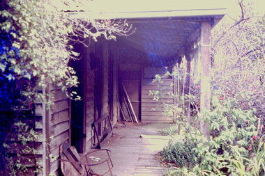 Kew Historical Society Inc
Slide - 'Reno', St John 's Parade, 1977
‘Reno’, stood on the east side of St John’s Parade. Its earliest recorded owner was the architect Samuel Cocking who lived there from c.1865 until his death in 1888. The original landholding was bordered by Cotham Road, Glenferrie Road, Wellington Street, and Charles Street. The southern portion of this land included a fine orchard, with many imported trees. The old summer house, at first in the orchard, was later removed to the house garden. The MMBW Detail Plan No.1576 (1904) shows the remaining portion of the original land holding, including a semi-circular pathway at the front, and garden features such as an aviary, a fountain and grotto, and a fernery. The garden including rare plants supplied by Baron Von Mueller, surrounds the cottage in a tangled frenzy. Despite a ‘local significance’ classification by the National Trust, the house was demolished in 1977.Rare photograph of an historically important weatherboard cottage in St John's Parade.Colour positive transparency (slide) of the verandah of 'Reno' in St John's Parade, Kew (demolished 1977). historic houses -- kew (vic.), reno -- st john's parade -- kew (vic.) -
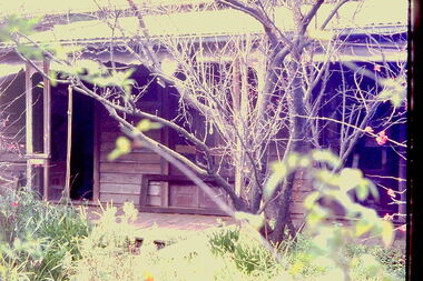
 Kew Historical Society Inc
Slide - 'Reno', St John 's Parade, 1977
‘Reno’, stood on the east side of St John’s Parade. Its earliest recorded owner was the architect Samuel Cocking who lived there from c.1865 until his death in 1888. The original landholding was bordered by Cotham Road, Glenferrie Road, Wellington Street, and Charles Street. The southern portion of this land included a fine orchard, with many imported trees. The old summer house, at first in the orchard, was later removed to the house garden. The MMBW Detail Plan No.1576 (1904) shows the remaining portion of the original land holding, including a semi-circular pathway at the front, and garden features such as an aviary, a fountain and grotto, and a fernery. The garden including rare plants supplied by Baron Von Mueller, surrounds the cottage in a tangled frenzy. Despite a ‘local significance’ classification by the National Trust, the house was demolished in 1977.Rare photograph of an historically important weatherboard cottage in St John's Parade.Colour positive transparency (slide) of the a doorway of 'Reno' in St John's Parade, Kew (demolished 1977). historic houses -- kew (vic.), reno -- st john's parade -- kew (vic.) -
 Kew Historical Society Inc
Slide - 'Reno', St John 's Parade, 1977
‘Reno’, stood on the east side of St John’s Parade. Its earliest recorded owner was the architect Samuel Cocking who lived there from c.1865 until his death in 1888. The original landholding was bordered by Cotham Road, Glenferrie Road, Wellington Street, and Charles Street. The southern portion of this land included a fine orchard, with many imported trees. The old summer house, at first in the orchard, was later removed to the house garden. The MMBW Detail Plan No.1576 (1904) shows the remaining portion of the original land holding, including a semi-circular pathway at the front, and garden features such as an aviary, a fountain and grotto, and a fernery. The garden including rare plants supplied by Baron Von Mueller, surrounds the cottage in a tangled frenzy. Despite a ‘local significance’ classification by the National Trust, the house was demolished in 1977.Rare photograph of an historically important weatherboard cottage in St John's Parade.Colour positive transparency (slide) of the verandah of 'Reno' in St John's Parade, Kew (demolished 1977). historic houses -- kew (vic.), reno -- st john's parade -- kew (vic.)