Showing 10710 items matching "projects"
-
 Melbourne Tram Museum
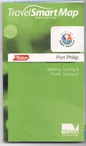
Document, Ministry of Transport, "Travel Smart Map - Port Phillip", 2010
Gives extensive details of walking cycling Public Transport in Port Phillip. Printed 2010. Yields information about Port Phillip transport and other services in 2010Map - pocket - 28 fold - showing walking, cycling and public transport in the City of Port Phillip, using a Melway Map base along with public transport information, Metcard, cycling and walking groups.tramways, melbourne, tram services, bus services, railways, port phillip, cyclists -
 Eltham District Historical Society Inc
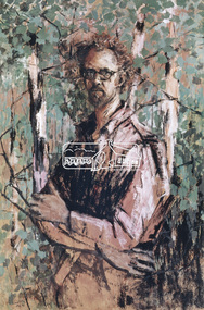
Photograph, Self Portrait - Clifton Pugh (1962), 1971
Clifton Pugh (1924-1990) was born at Richmond Victoria, and educated at various schools including Briar Hill Primary, Eltham Higher Elementary School and Ivanhoe Grammar. He studied art at the National Gallery School of Victoria 1948-52. Pugh is recognised as a one of Australia’s foremost painters. He is represented in major galleries throughout the country and overseas. He founded the “Dunmoochin” artists colony at Cottles Bridge.This photo forms part of a collection of photographs gathered by the Shire of Eltham for their centenary project book, "Pioneers and Painters: 100 years of the Shire of Eltham" by Alan Marshall (1971). The collection of over 500 images is held in partnership between Eltham District Historical Society and Yarra Plenty Regional Library (Eltham Library) and is now formally known as the 'The Shire of Eltham Pioneers Photograph Collection.' It is significant in being the first community sourced collection representing the places and people of the Shire's first one hundred years.4 x 5 inch colour reversal film (1) Condition: May not be true to colour of original work. Scanned from a 4 x 5 inch colour transparency which was taken c.1970 (approx. 50 years old) and which has undergone significant colour degradation towards the red spectrum. Allowances made for colour cast correction in scan with best guess for white balance. In some cases, significant light flare is reflected off glossy surface of original work at camera lens causing quality issues.clifton pugh, sepp, shire of eltham pioneers photograph collection, self portrait -
 Eltham District Historical Society Inc
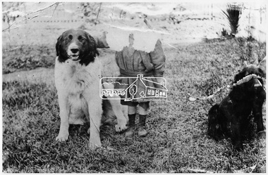
Photograph, William Hurst Gray, 1900
William Hurst Gray (1898-?), age about three years, with pet dogs at his Grandfather Frederick George Hurst's home, Allwood, Hurstbridge. William was born in Jolimont, Vic. in 1898.This photo forms part of a collection of photographs gathered by the Shire of Eltham for their centenary project book, "Pioneers and Painters: 100 years of the Shire of Eltham" by Alan Marshall (1971). The collection of over 500 images is held in partnership between Eltham District Historical Society and Yarra Plenty Regional Library (Eltham Library) and is now formally known as 'The Shire of Eltham Pioneers Photograph Collection.' It is significant in being the first community sourced collection representing the places and people of the Shire's first one hundred years.Digital imagesepp, shire of eltham pioneers photograph collection, hurstbridge, william hurst gray, dogs, pets, allwood -
 Melbourne Tram Museum
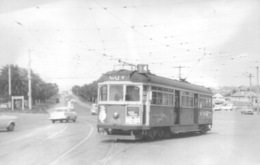
Photograph - Black and White - W6 965 reversing at Elsternwick, John Alfred
Photo shows - W6 965 (route 4, City) reversing at Elsternwick, using the Point Ormond leg of the triangle of the intersection at the intersection with Brighton Road and Glenhuntly Rd, due to the work to replace the Elsternwick level crossing. Dated 2-10-1960.Yields information about alterations to tram services during a level crossing removal project.Photograph - Black and White - W6 965 reversing at ElsternwickHas details typed on rear, date stamp and John Alfred Stamp. tramways, tramcars, w6 class, elsternwick, brighton road, glenhuntly road, tram 965, route 4 -
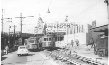 Melbourne Tram Museum
Photograph - Black and White - Swan Street track lowering, John Alfred, 1957
Photo shows - works in Swan Street Richmond to lower the tram tracks under the Railway bridge which were later replaced by an open web girder truss bridge. The track on the left has been completed while on the right, the original road surface can be seen as well as the temporary track. Shows the abutment for a new railway bridge on the right, for the six tracks to South Yarra. Tram W2 330 (left, Camberwell Depot, route 76) and 339 (City, route 77) are passing each other. In the background is a large advertisement for Pattersons home furnishings. Photo dated 1957.Yields information about alterations to tram services during road reconstruction project.Photograph - Black and White - Swan Street track lowering Has details handwritten on rear, date stamp and John Alfred Stamp. tramways, tramcars, swan street, richmond, route 77, railways, bridges, tram 330, tram 339 -
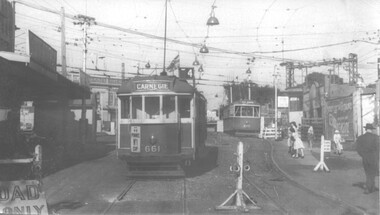 Melbourne Tram Museum
Photograph - Black and White - trams 661 and 675 Elsternwick, John Alfred, 1960
Black and white photograph of trams W3 661 (Route 4 Carnegie) and X2 675 (Point Ormond) , Glenhuntly Road, Elsternwick Station, during the lowering of the railway line, 1960. Photo by John Alfred. Yields information about alterations to tram services during a level crossing removal project.Photograph - Black and White - trams 661 and 675 ElsternwickHas details handwritten on rear, and John Alfred Stamp. tramways, tramcars, glenhuntly rd, level crossing, elsternwick, tram 661, tram 675, w3 class, x2 class, point ormond -
 Merbein District Historical Society
Book, Mildara Memories Merbein (2 copies), 1913-2006
george chaffey, mildara winery, ron haselgrove, jack schultz, brandy, mildara employees, herbert chaffey, george wakefield, redex car trial, mildara board, joy scherger, mildara sculpture, mildara forestation project, syd wells, richard haselgrove, scar tree, chaffey landing, jimmy watson trophy, mildara fire -
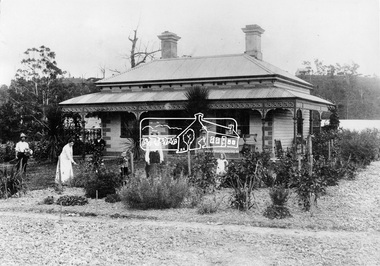 Eltham District Historical Society Inc
Negative - Photograph, Allwood, Hurstbridge, 1905
Allwood, Hurstbridge, 1905. Hurst/Gray family in the garden in front of the Victorian style Allwood house with lace iron work on the verandah. Left to Right: Whittaker, Mrs. Catherine Hurst, Frederick George Hurst (at rear), Hurst Gray, Mrs. Frances Ellen Gray (nee Hurst), William (Bill) George Gray, Sylvia Gray (later Birch). Frederick and Catherine Hurst relocated this Victorian style weatherboard home from an inner Melbourne suburb to its present site on their Allwood property. Mr Charles Verso, builder and farmer, reassembled and refurbished the home for the Hurst’s. In 1897 Frederick and Catherine’s daughter, Frances Ellen, married William (Bill) George Gray of Cottlesbridge and the newlyweds moved into the new house. Frederick and Catherine Hurst moved into a little cottage, ‘Mia Mia’, on the other side of the Diamond Creek. William and Frances Gray established Allwood Nursery and by 1900 most of the Allwood property was under orchard, largely apples, pears, cherry plums and peaches. They also developed an extensive nursery, growing seedling stock for supply to other local orchardists and the overseas market. Cross Ref: Sepp_1018 Source: Mrs. Ferguson, Hurstbridge This photo forms part of a collection of photographs gathered by the Shire of Eltham for their centenary project book,"Pioneers and Painters: 100 years of the Shire of Eltham" by Alan Marshall (1971). The collection of over 500 images is held in partnership between Eltham District Historical Society and Yarra Plenty Regional Library (Eltham Library) and is now formally known as The Shire of Eltham Pioneers Photograph Collection.' It is significant in being the first community sourced collection representing the places and people of the Shire's first one hundred years.Digital image 4 x 5 inch B&W Neg Print 20 x 25 cm (x2)shire of eltham pioneers photograph collection, hurstbridge, hurst family, sylvia gray, hurst gray, whittaker, allwood house, allwood, frederick george hurst, gray family, mrs. catherine hurst, mrs. frances ellen gray (nee hurst), william (bill) george gray -
 Eltham District Historical Society Inc
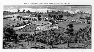
Photograph, Samuel Calvert, Eltham, The Illustrated Australian News, December 26, 1884, p212, 1884
A description in the newspaper near the illustration (page 210) reads as follows: "Eltham is a pretty little township on the Yarra Flats road, about 14 miles east north east of Melbourne, from which place there is communication by way of Heidelberg. It has a population of nearly 400 inhabitants, but in addition it is the centre of a large district extending over about 203 square miles, having a population of 2344. The land in the district is mostly used for grazing purposes, although as a rule the small farms grow a good deal of wheat, oats and other agricultural produce. A large quantity of fruit, especially raspberries and strawberries, is also produced, the rich alluvial flats along the creek upon which the township is situated being very well adapted for that purpose. Gold has also been found in the vicinity of the township, but not in remunerative quantities". This photo forms part of a collection of photographs gathered by the Shire of Eltham for their centenary project book,"Pioneers and Painters: 100 years of the Shire of Eltham" by Alan Marshall (1971). The collection of over 500 images is held in partnership between Eltham District Historical Society and Yarra Plenty Regional Library (Eltham Library) and is now formally known as 'The Shire of Eltham Pioneers Photograph Collection.' It is significant in being the first community sourced collection representing the places and people of the Shire's first one hundred years.Digital imageshire of eltham pioneers photograph collection, eltham, illustrated australian news -
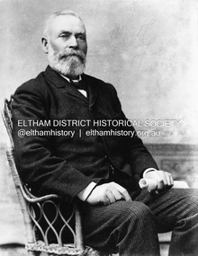 Eltham District Historical Society Inc
Photograph, Ewen Hugh Cameron (1832-1915), c.1910
Ewen Hugh Cameron (1831- 27 September 1915) was born at Kilmonivaig, Inverness Scotland. He migrated to Melbourne in “The Hurricane” in 1853 and in 1855 tried his luck at the newly-opened Andersons Creek Goldfield. Two years later he was appointed first postmaster at Warrandyte and ran the store there. In 1863 he took up the 100 acre farm “Pigeon Bank” at Kangaroo Ground where he lived until his death. In 1874 Cameron was elected as the Member for Evelyn in the Victorian Legislative Assembly and held the seat until he retired in 1914 as “Father of the House”. He held a number of ministerial and other important Parlimentary positions. The most notable was Chairman of the Railways Standing Committee, which was responsible for much of the Railway development in Victoria. Concurrently with his Parliamentary career, he was a member of the Eltham Roads Board and later Council for more than 50 years. In 1867 he married Agnes Bell, a daughter of Kangaroo Ground pioneers. They had eight sons and three daughters. This photo forms part of a collection of photographs gathered by the Shire of Eltham for their centenary project book,"Pioneers and Painters: 100 years of the Shire of Eltham" by Alan Marshall (1971). The collection of over 500 images is held in partnership between Eltham District Historical Society and Yarra Plenty Regional Library (Eltham Library) and is now formally known as the 'The Shire of Eltham Pioneers Photograph Collection.' It is significant in being the first community sourced collection representing the places and people of the Shire's first one hundred years.Digital image B&W printsepp, shire of eltham pioneers photograph collection, kangaroo ground, e.h. cameron, member for evelyn, victorian parliament, legislative assembly, ewen cameron, ewen hugh cameron, ewan hugh cameron, people, pigeon bank -
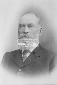 Eltham District Historical Society Inc
Photograph, The Hon. Ewen Hugh Cameron, Member for Evelyn in Legislative Assembly, Victorian Parliament, for 40 years from 1874-1914
Ewen Hugh Cameron (1831- 27 September 1915) was born at Kilmonivaig, Inverness Scotland. He migrated to Melbourne in “The Hurricane” in 1853 and in 1855 tried his luck at the newly-opened Andersons Creek Goldfield. Two years later he was appointed first postmaster at Warrandyte and ran the store there. In 1863 he took up the 100 acre farm “Pigeon Bank” at Kangaroo Ground where he lived until his death. In 1874 Cameron was elected as the Member for Evelyn in the Victorian Legislative Assembly and held the seat until he retired in 1914 as “Father of the House”. He held a number of ministerial and other important Parlimentary positions. The most notable was Chairman of the Railways Standing Committee, which was responsible for much of the Railway development in Victoria. Concurrently with his Parliamentary career, he was a member of the Eltham Roads Board and later Council for more than 50 years. In 1867 he married Agnes Bell, a daughter of Kangaroo Ground pioneers. They had eight sons and three daughters.This photo forms part of a collection of photographs gathered by the Shire of Eltham for their centenary project book, "Pioneers and Painters: 100 years of the Shire of Eltham" by Alan Marshall (1971). The collection of over 500 images is held in partnership between Eltham District Historical Society and Yarra Plenty Regional Library (Eltham Library) and is now formally known as the 'The Shire of Eltham Pioneers Photograph Collection.' It is significant in being the first community sourced collection representing the places and people of the Shire's first one hundred years.Digital imagesepp, shire of eltham pioneers photograph collection, kangaroo ground, e.h. cameron, member for evelyn, victorian parliament, legislative assembly, ewen cameron, ewen hugh cameron -
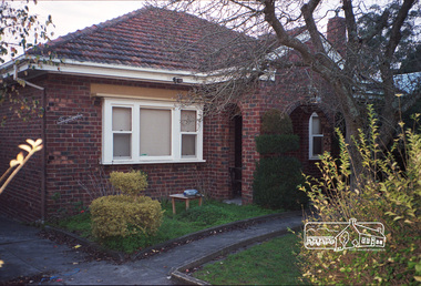 Eltham District Historical Society Inc
Photograph, Margaret Ball, 13 Luck Street, Eltham, June 1999, 1999
House built by George and Alma Le Brocq. George was the 2nd Secretary of the Diamond Valley League Football. House sold September 2000.The Margaret Ball (Pre 1960s Houses) Collection was a personal project initiated to mark the year 2000 and arose as a result of the disappearance of many pre-1960s parts of Eltham due to development. Approximately 200 pre-1960s style houses that were left in Eltham between Main Road and east to Bible Street, between Cecil Street to the north and south to Dalton Street were photographed in late 1999. Not all of the houses could be photographed; some because the garden or trees blocked the view of the house, others because of rubbish or cars were in the way, some because people were working on the house or in the gardens at the time.Roll of 35mm colour negative film, 10 stripsFuji 200eltham, houses, streets, margaret ball (pre 1960s houses) collection, luck street, george le brocq, alma le brocq -
Bialik College
Mixed media (item) - 2011 Library Project Exterior images
Images taken in association with the development of the school library at Bialik College in 2011. 2010s, 2011, library, building, heritage, development, bialik college -
Bialik College
Mixed media (item) - 2011 Library Project Interior
Photographs taken at Bialik College Library, the interior, in 2011. 2011, 2010s, library, building, heritage, bialik college -
University of Melbourne, Burnley Campus Archives
Newspaper - Newspaper Cutting, The Herald, £100,000 garden plan …Olympic Village, 1954
A rough sketch and text in the "Herald," 10.07.1954 of the proposed plan for the Olympic Village in Heidelberg. Drawn by Erica Ball (1948).the herald, sketch, olympic games 1956, olympic village, erica ball, heidelberg, landscape project olympic village -
 Flagstaff Hill Maritime Museum and Village
Document - Plan, Victorian Harbours Warrnambool, Victorian Harbours, Warrnambool, Plan to Accompany Sir John Coode's Report, 28-02-1879
This plan is of great significance to the local history of Warrnambool, in particular the Breakwater and its impact on Warrnambool's maritime and trade history. The plan shows the existing jetties at the Port of Warrnambool, plus the partially erected Breakwater and proposed works to the Breakwater by both the Borough of Warrnambool Surveyor and Sir John Coode. The plan was signed 28th February 1879 by Sir John Coode. The legend at the bottom left describes the existing works and the proposed works. The Warrnambool Breakwater Sir John Coode was a British harbour engineer. He was brought to Melbourne by the Melbourne Harbour Trust to advise on works to improve the Port of Melbourne. The Victorian Government commissioned him to present a plan to complete the Warrnambool Breakwater. His original plan was too expensive so he prepared a revised plan for a shorter structure. The work was completed in 1890. The construction proved to be too short to protect adequately from the weather and didn't allow enough depth for larger vessels to come into port. The decreasing trade was further affected by siltation in the bay due to the breakwater, and the completion of the railway line. The situation of the harbour became a real problem that, by 1910, required continuous dredging. In 1914 the Breakwater was extended but proved to be a failure because the work began to subside and by 1920 about two thirds of the harbour was silted up. Alterations made in the 1920's increased the silting problem and by the 1940's the harbour was no longer used. More alterations were made in the 1950's and 1960's. The Warrnambool Breakwater is registered as a place of significance on the Victorian Heritage Database. This plan of the proposed works for the existing Warrnambool Breakwater is of great significance to the local history of Warrnambool, in particular the Breakwater and its impact on Warrnambool's maritime and trade history. The Warrnambool Breakwater is registered as a place of significance on the Victorian Heritage Database (VHR H2024). It is historically significant to Victoria as one of the most important maritime engineering projects in Victoria in the late 19th century. The Warrnambool Breakwater is of historical significance as one of the most important maritime engineering projects in Victoria in the late nineteenth century. It is evidence of Victoria's nineteenth century investment in regional port infrastructure and the development of Victorian coastal shipping. It is of significance for its association with the English civil engineer Sir John Coode, the most distinguished harbour engineer of the nineteenth century, who was brought to Victoria to advise on works to improve the Port of Melbourne, but was retained by the Government to advise on improvements to the harbours at Portland, Geelong, Port Fairy, and Lakes Entrance, as well as Warrnambool. His projects for Melbourne, Lakes Entrance and Warrnambool were major engineering projects of the nineteenth century. The breakwater is historically significant as a reminder of Warrnambool's early maritime history as a Western District port, and as one of Victoria's major 'outer ports'. While the Warrnambool Breakwater is a demonstration of the engineering skills of the nineteenth century, it also demonstrates the limitations of knowledge relating to sedimentology at the time and the confidence apparent in a number of nineteenth century plans which assumed that natural forces could be overcome or contained by engineering.Plan of Warrnambool Harbour, Port of Warrnambool, dated 28 Feb 1879. Plan shows existing Breakwater and work proposed by both Warrnambool Borough Surveyor and Sir John Coode. Plan has gold coloured quarter-dowel rods top and bottom and a metal ring at the top. Stamped with title. Signed by Sir John Coode.Stamped "VICTORIAN HARBOURS / WARRNAMBOOL / PLAN / to accompany / SIR JOHN GOODE'S REPORT / DATED 28 FEB 1879" Signature "John Coode"flagstaff hill, warrnambool, maritime museum, shipwreck coast, great ocean road, sir john coode, borough of warrnambool surveyor, plan of warrnambool, victorian harbours, warrnambool harbour, warrnambool breakwater, port of warrnambool, vhd vhr h2024, flagstaff hill maritime museum & village, maritime village, map, chart, plan, lady bay, breakwater, jetty, pier, vhr h2024, proposed works, 1879 -
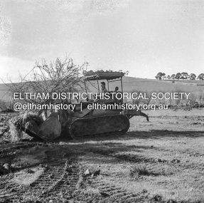 Eltham District Historical Society Inc
Negative - Photograph, J.A. McDonald, Kangaroo Ground-Queenstown Road, Aug. 1960
(Kangaroo Ground-St Andrews Road) “Rymers” Corner – shifting Hawthorn hedges on Tompkins property Council’s Drott 6 Woods Drott 9 August 1960 Showing hedge in rear already transported EDHS_05569-55 (EDHS_05577-3/4) and EDHS_05569-56 (EDHS_05577-5/6) - Hawthorn Hedges, Kangaroo Ground 50-50 ELTHAM, CUT THE HEDGES! While all of us are talking about the road toll, Eltham Council must have been in long recess. Around Kangaroo Ground are farmers’ hawthorn hedges shrouding dangerous corners on busy roads. If the council does not insist on their removal for a distance clear enough for safe driving, then it must be held culpable for the accidents that are bound to happen. – WAKE UP (Melbourne) ELTHAM, CUT THE HEDGES! 50-50 (1960, 6 January), The Sun (News clipping held in SEA_74-1_007) ‘BAD HEDGES’ WILL GO “We know there are some bad hedges on corners in the Kangaroo Ground area, but roadworks this year will eliminate them,” the Eltham Shire secretary, Mr Maxwell B. Watson, said yesterday. A reader in 50-50 yesterday complained of farmers’ hawthorn hedges obscuring drivers’ views at bad corners on busy roads in the Kangaroo Ground district. Mr Watson said the roadworks were deviations to remove the sharp turns, and the road would cut back into paddocks. The hedges would go at the same time. Meanwhile, the shire had power to require owners to cut back hedges, and this would be done if specific instances were reported and found justifiable. ‘BAD HEDGES’ WILL GO (1960, January 7), The Sun (News clipping held in SEA_74-1_007)Record of various Shire of Eltham infrastructure works undertaken during the period of 1952-1962 involving bridge and road reconstruction projects, sometimes with Eltham Shire Council Project Reference numbers quoted. It was during this period that a number of significant improvements were made to roads and new bridges constructed within the shire that remain in place as of present day (2022). In many situations, the photos provide a tangible visible record of infrastructure that existed throughout the early days of the Shire. The album was put together by or under the direction of the Shire Engineer, J.A. McDonald.infrastructure, shire of eltham, 1960-08, garden hill, kangaroo ground, kangaroo ground-queenstown road, kangaroo ground-st andrews road, rymers corner, bulldozer, drott -
 Eltham District Historical Society Inc
Negative - Photograph, J.A. McDonald, Kangaroo Ground-Queenstown Road, Aug. 1960
(Kangaroo Ground-St Andrews Road) “Rymers” Corner – shifting Hawthorn hedges on Tompkins property Council’s Drott 6 Woods Drott 9 August 1960 Showing method of lifting clumps of Hawthorn EDHS_05569-55 (EDHS_05577-3/4) and EDHS_05569-56 (EDHS_05577-5/6) - Hawthorn Hedges, Kangaroo Ground 50-50 ELTHAM, CUT THE HEDGES! While all of us are talking about the road toll, Eltham Council must have been in long recess. Around Kangaroo Ground are farmers’ hawthorn hedges shrouding dangerous corners on busy roads. If the council does not insist on their removal for a distance clear enough for safe driving, then it must be held culpable for the accidents that are bound to happen. – WAKE UP (Melbourne) ELTHAM, CUT THE HEDGES! 50-50 (1960, 6 January), The Sun (News clipping held in SEA_74-1_007) ‘BAD HEDGES’ WILL GO “We know there are some bad hedges on corners in the Kangaroo Ground area, but roadworks this year will eliminate them,” the Eltham Shire secretary, Mr Maxwell B. Watson, said yesterday. A reader in 50-50 yesterday complained of farmers’ hawthorn hedges obscuring drivers’ views at bad corners on busy roads in the Kangaroo Ground district. Mr Watson said the roadworks were deviations to remove the sharp turns, and the road would cut back into paddocks. The hedges would go at the same time. Meanwhile, the shire had power to require owners to cut back hedges, and this would be done if specific instances were reported and found justifiable. ‘BAD HEDGES’ WILL GO (1960, January 7), The Sun (News clipping held in SEA_74-1_007)Record of various Shire of Eltham infrastructure works undertaken during the period of 1952-1962 involving bridge and road reconstruction projects, sometimes with Eltham Shire Council Project Reference numbers quoted. It was during this period that a number of significant improvements were made to roads and new bridges constructed within the shire that remain in place as of present day (2022). In many situations, the photos provide a tangible visible record of infrastructure that existed throughout the early days of the Shire. The album was put together by or under the direction of the Shire Engineer, J.A. McDonald.infrastructure, shire of eltham, 1960-08, garden hill, kangaroo ground, kangaroo ground-queenstown road, kangaroo ground-st andrews road, rymers corner, bulldozer, drott -
 Eltham District Historical Society Inc
Negative - Photograph, J.A. McDonald, Kangaroo Ground-Queenstown Road, Aug. 1960
(Kangaroo Ground-St Andrews Road) “Rymers” Corner – shifting Hawthorn hedges on Tompkins property Council’s Drott 6 Woods Drott 9 August 1960 EDHS_05569-55 (EDHS_05577-3/4) and EDHS_05569-56 (EDHS_05577-5/6) - Hawthorn Hedges, Kangaroo Ground 50-50 ELTHAM, CUT THE HEDGES! While all of us are talking about the road toll, Eltham Council must have been in long recess. Around Kangaroo Ground are farmers’ hawthorn hedges shrouding dangerous corners on busy roads. If the council does not insist on their removal for a distance clear enough for safe driving, then it must be held culpable for the accidents that are bound to happen. – WAKE UP (Melbourne) ELTHAM, CUT THE HEDGES! 50-50 (1960, 6 January), The Sun (News clipping held in SEA_74-1_007) ‘BAD HEDGES’ WILL GO “We know there are some bad hedges on corners in the Kangaroo Ground area, but roadworks this year will eliminate them,” the Eltham Shire secretary, Mr Maxwell B. Watson, said yesterday. A reader in 50-50 yesterday complained of farmers’ hawthorn hedges obscuring drivers’ views at bad corners on busy roads in the Kangaroo Ground district. Mr Watson said the roadworks were deviations to remove the sharp turns, and the road would cut back into paddocks. The hedges would go at the same time. Meanwhile, the shire had power to require owners to cut back hedges, and this would be done if specific instances were reported and found justifiable. ‘BAD HEDGES’ WILL GO (1960, January 7), The Sun (News clipping held in SEA_74-1_007)Record of various Shire of Eltham infrastructure works undertaken during the period of 1952-1962 involving bridge and road reconstruction projects, sometimes with Eltham Shire Council Project Reference numbers quoted. It was during this period that a number of significant improvements were made to roads and new bridges constructed within the shire that remain in place as of present day (2022). In many situations, the photos provide a tangible visible record of infrastructure that existed throughout the early days of the Shire. The album was put together by or under the direction of the Shire Engineer, J.A. McDonald.infrastructure, shire of eltham, 1960-08, garden hill, kangaroo ground, kangaroo ground-queenstown road, kangaroo ground-st andrews road, rymers corner, bulldozer, drott -
 Falls Creek Historical Society
Document - Report - Proposed Falls Creek Tourist Hotel Project
Bob (Herman) Hymans (a former member of the Royal Netherlands Navy) was born in Bloemendaal, Holland on 30th September 1922. During World War II he fought against the Japanese in the Dutch East Indies (now Indonesia) and was imprisoned in Changi and on the Burma Railway. After gaining qualifications as a Ski Instructor, Bob arrived in Falls Creek in July 1950. Working as an Instructor and Supervisor at Bogong Lodge, Bob decided his future was in accommodation. He was successful in negotiating an indenture for land from the State Electricity Commission (SEC). It took Bob two years to build his Grand Coeur Chalet but, tragically, it was burned down in August 1961. Bob also built the first Chairlift in Australia. This was a single chairlift and the structure was built from wooden electricity poles. He was constantly full of new ideas and proposals for the village. Bob Hymans died on 7th July 2007. This Collection of documents and letters tells the story of Bob's endeavours to develop Falls Creek into the ski village it is today.This item is significant because it documents proposals put forward by Bob Hymans to develop facilities in the Falls Creek Tourist Area.A typed report of aspects of Bob Hymans' application for a lease of land to establish a new hotel at Falls Creek. The document has some works underlined and handwritten notes added.falls creek tourist area management committee, hymans' hotel plans, falls creek development -
 Falls Creek Historical Society
Letter - Letter Re Diagram Of Governor Phillip Park, Parish Of Narrabeen
Bob Hymans Collection Bob (Herman) Hymans (a former member of the Royal Netherlands Navy) was born in Bloemendaal, Holland on 30th September 1922. During World War II he fought against the Japanese in the Dutch East Indies (now Indonesia) and was imprisoned in Changi and on the Burma Railway. After gaining qualifications as a Ski Instructor, Bob arrived in Falls Creek in July 1950. Working as an Instructor and Supervisor at Bogong Lodge, Bob decided his future was in accommodation. He was successful in negotiating an indenture for land from the State Electricity Commission (SEC). It took Bob two years to build his Grand Coeur Chalet but, tragically, it was burned down in August 1961. Bob also built the first Chairlift in Australia. This was a single chairlift and the structure was built from wooden electricity poles. He was constantly full of new ideas and proposals for the village. Bob Hymans died on 7th July 2007. This Collection of documents and letters tells the story of Bob's endeavours to develop Falls Creek into the ski village it is today.This letter is significant because it reflects the desire for Bob Hymans to consider projects outside of Falls Creek.A letter from Department of Lands, New South Wales accompanying a diagram of Governor Phillip Park. Plans are no longer available.falls creek administration, governor phillip park -
 Greensborough Historical Society
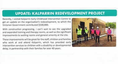
Article - Newsletter Clipping, Colin Brooks, Update: Kalparrin Redevelopment Project, November 2020
Update on Kalparrin Early Childhood Intervention Centre which had received funds from the Victorian Government to redevelop amenities at the centre.Text with small colour photokalparrin, colin brooks -
 Bendigo Historical Society Inc.
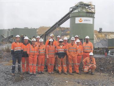
Photograph - Kangaroo Flat Gold Mine Collection: Unity Mining employees
A3 laminated sheet with colour photographs of mine personnel. Fourteen men and one woman dressed in orange high-vis clothing and wearing hard hats. In background, part of processing plant with 'Unity Mining Limited' on side of tank. Kangaroo Flat Gold mine site in far background. kangaroo flat gold mine, bendigo mining nl, new bendigo gold project, goldmining, personnel, doug buerger, colin burns, unity mining -
 National Vietnam Veterans Museum (NVVM)
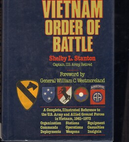
Book, Stanton, Shelby, Vietnam Order of Battle. (Copy 2), 1986
Shelby Stanton's Vietnam Order of Battle has been the "Bible" for the Army's Southeast Asia War Records project, which has been hastened immeasurably by having this accurate and excellently compiled reference work at hand - it is an information source without equal.Shelby Stanton's Vietnam Order of Battle has been the "Bible" for the Army's Southeast Asia War Records project, which has been hastened immeasurably by having this accurate and excellently compiled reference work at hand - it is an information source without equal. deployment of forces, united states. army -- history -- vietnamese conflict, 1961-1975 -
 Melbourne Legacy
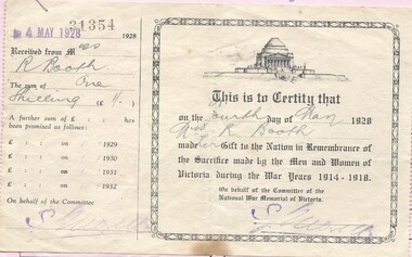
Document, Receipt, 1928
In 1928 the Committee of the National War Memorial of Victoria called on the public to donate funds to the building of the Shrine of Remembrance (see booklet at 01206). This receipt is an example of the certificate provided to the donor to show their contribution. The donation from Miss R. Booth was for 1 shilling. The right hand portion was intended to be detached and kept, it did not record the amount as it was to show she had made a gift to the Shrine regardless of the amount. In the booklet at 01206 people were asked to donate whatever they could depending on their circumstances and made a point that the amount wouldn't be shown on the certificate. The Legacy Interview/Report Form shows that Mrs R Innes donated this artefact to Legacy in 1981. It is part of the business practice of recording how things were donated to Legacy and all the details of the items. Items were in an envelope with other photos and programmes from different items relating to the Shrine of Remembrance - including discussions on its location and design. Labelled 'Shrine of Remembrance S1 - S14' it was part of an old archive numbering system, that showed there has been efforts in the past to collect, order and save items of Legacy's history. (01181 - 01190, 01206 - 01211).A record of the general public contributing to the building of the Shrine of Remembrance, in 1928 Victorians were asked to contribute approximately £100,000 to the building project. Also that items relating to the Shrine were donated to Legacy for archiving and that procedures were in place to record the event. There was an effort to record historical events for the "Archive Committee" which collected this and other documents relating to the Shrine together in a file (see items 01181 - 01190, 01206 - 01211)A receipt of a donation in 1928 to the fund for building the Shrine, off white paper and black print. Plus a pink foolscap Interview/Report Form detailing the donation of the receipt to Legacy in 1981, black print and blue pen handwriting.S14 in red pen in top right corner. Handwritten message signed by J Mangan in blue pen.memorial, shrine of remembrance -
Clunes Museum
Booklet, Clunes Street Beautification Project
Loosely bound A4 with clear cover contains proposal for Clunes beautification with street drawings, undated, unnumberedbeautification, cheshire, street plan -
University of Melbourne, Burnley Campus Archives
Newspaper - Newspaper Cutting, The Age, Urban Plants Project Taking Wing, 07.10.2022
university of melbourne, city of melbourne, plants, wildlife, chris williams, cities -
 Eltham District Historical Society Inc
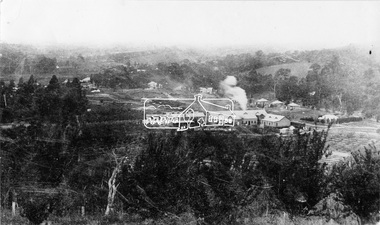
Negative - Photograph, Cool Stores, Hurstbridge, 1917
View overlookng Hurstbridge with the Cool Stores complex in the middle of the view (opened in March 1915) surrounded by an orchard of fruit trees. Local orchardists housed their fruits in cold storage here before despatch by rail to domestic and international markets, sometimes out of season.This photo forms part of a collection of photographs gathered by the Shire of Eltham for their centenary project book, "Pioneers and Painters: 100 years of the Shire of Eltham" by Alan Marshall (1971). The collection of over 500 images is held in partnership between Eltham District Historical Society and Yarra Plenty Regional Library (Eltham Library) and is now formally known as 'The Shire of Eltham Pioneers Photograph Collection.' It is significant in being the first community sourced collection representing the places and people of the Shire's first one hundred years.Digital image 4 x 5 inch B&W Negshire of eltham pioneers photograph collection, hurstbridge, cool stores, orchards, cool store -
 National Vietnam Veterans Museum (NVVM)
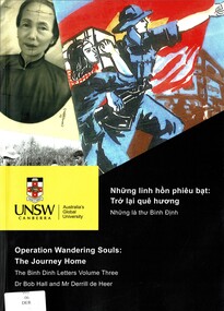
Book, de Heer, Derrill, Ross, Andrew Dr., Griffin, Amy Dr. and Hall, Bob Dr, Operation Wandering Souls: The Journey Home: The Binh Dinh Letters, Volume Three, 2013
A collection of letters during the Bihn Dinh era.A collection of letters during the Bihn Dinh era.de heer, derrill. -- operation wandering souls project, hall, bob. -- operation wandering souls project, unsw canberra -- operation wandering souls project, vietnam war, 1961-1975 -- veterans -- australia, binh dinh