Showing 124167 items
matching main-road
-
 Lakes Entrance Historical Society
Postcard - Main Street Bairnsdale, 1895 c
Eastwood Brothers shown in image beside the Savings BankTinted postcard looking east of businesses on the north side of Main Street Bairnsdale Victoriatownships, businesses -
 Warrnambool and District Historical Society Inc.
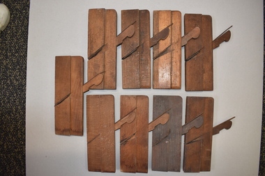
Small Wood Planes, Late 19th century
These items are among several tools that are believed to have belonged to the Warrnambool carpenter and businessman, Henry Phillips. English-born Henry Phillips (1821-1896) came to Australia with his wife Elizabeth in 1849. They lived for some time in Port Fairy. In 1865 Henry formed a partnership with Christopher Beattie and established the Warrnambool undertaking business of Beattie and Phillips. This business continued on after the deaths of the founders and lasted until the year 2000. In Warrnambool Henry Phillips was involved in the management of the Mechanics Institute. These nine tools are small wooden planes, similar in size and design. In each tool the main wooden section is rectangular in shape with an additional wooden piece attached to one side. In each a metal blade has been inserted at an angle into a slot on top of the main wooden piece and a small wooden piece rests on the blade. The blade protrudes at the base of the main wooden piece to form a planing mechanism.vintage tools, henry phillips, warrnambool -
 Kew Historical Society Inc
Photograph - Electric tram line construction in Cotham Road, Kew, E.J. Dower, 1913
One of a series of photographs, taken by Edgar James Dower in the second decade of the twentieth century. Born and raised in Olinda, his family later moved to Surrey Hills. He worked as an adult as a clerk in the city office of the Metropolitan Gas Company, and in his role as a 'collector', he was able to photograph scenes including the construction of tramlines and associated buildings in Kew, Hawthorn, Camberwell and Surrey Hills. Later he established a real estate agency with his brother - the E.J. Dower Real Estate Agency, Dandenong Office.The image is an historically significant record of the development of transport infrastructure which was used to connect Victorians in the first two decades of the twentieth century. This development resulted from increases in population and the consequent extension of Melbourne's suburbs. The photographs, both individually and collectively, richly detail the labour of workers and the tools and machinery used to create and extend Melbourne's tram network in the years preceding and during World War 1.Digital copy of an original mounted photograph depicting construction of a new electric tramline in Cotham Road, Kew. The photo shows a pair of horse drawn drays with workers posed beside them. An annotation on the reverse of the photo notes that the drays were used to transport the steel tram tracks from the Hawthorn Railway Station siding. Annotated verso: "1913 / Preparing for Electric Tram Cotham Road Kew / Metal [tracks] transported by horse and dray from Hawthorn Railway siding"theme --- travelling by tram, theme -- connecting victorians by transport and communications, cotham road -- kew (vic.), trams -- kew (vic.) -
 National Wool Museum
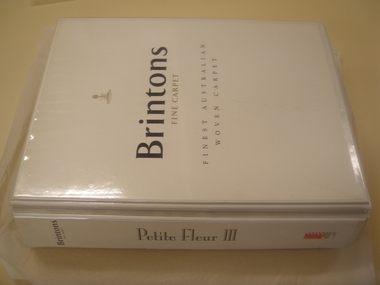
Book, Carpet Sample, Petite Fleur III
A sales book for the design range Petite Fleur III acquired when Brintons' Fellmonger Road factory closed.W7193 W7193_2 Page 1 of a history of Brintons Carpets. Page 2 of a history of Brintons Carpets. A list of catalogues/items in the Brintons Collection donated after closure of Fellmongers Road factory in July 2008.Brintons Fine Carpets Finest Australian Woven Carpets Petite Fleur III Davis Residence o/n 38806 1/10392 Please Ruturn to Design Studiofurnishing, brintons australia pty ltd brintons pty ltd (geelong) brintons ltd (uk), sales, samples -
Whitehorse Historical Society Inc.
Article, Councils slate transport plan, 1979
The reaction of Camberwell and Nunawading Councils to a newly released State Government plan for transport in the area.The reaction of Camberwell and Nunawading Councils to a newly released State Government plan for transport in the area. Most proposals are concerned with the extension of freeways or improvement of roads. Concern is expressed about the lack of public transport improvements.The reaction of Camberwell and Nunawading Councils to a newly released State Government plan for transport in the area.city of nunawading, city of camberwell, roads and streets, transport, public transport, eastern freeway -
 Bacchus Marsh & District Historical Society
Map, 'Map of Darley' circa 1877-1897
This map shows the early laid out streets and roads for the village of Darley and the main roads and streets in the central area of the township of Bacchus Marsh. The date of the map is not known. Landmarks indicated on the map including the Anglican Church in Church Street (Gisborne Road), opposite the Presbyterian Church, and the Baptist Church at its pre-1898 Main Street location suggest the map is dated between 1877 and 1897. Landholders names can be seen on some of the allotments of land marked in this map, including the names Clifton, Cosgrove, O'Hagan, McFarlane, Nagle, O'Hagan, Simpson and Vallence.A single page paper map showing the village of Darley and the township of Bacchus Marsh. Scale 10 chains to 1 inch. The map is pasted into a bound volume containing 76 maps or plans in total. High resolution digital image stored on BMDHS computer network. darley victoria maps, bacchus marsh victoria maps -
 Bayside Gallery - Bayside City Council Art & Heritage Collection
Photograph, Department of Crown Lands and Survey, Victoria, Melbourne Project: Brighton, 1976
The Department of Crown Lands and Survey (1857-1983) was responsible for the administration of survey and mapping and the sale, occupation and management of crown land throughout its existence. This aerial photograph shows parts of Brighton and was taken on 1 December 1976brighton, department of crown lands and survey, aerial photograph, bayside, port phillip bay, map, cartographic material, melbourne project 1976, brighton yacht club, middle brighton baths, north road, st kilda street, new street -
 Kew Historical Society Inc
Plan - Subdivision Plan, Plan of Subdivision of Part of Crown Portion 84 / Parish of Boroondara / County of Bourke / Lodged Plan No. 2217, Twentieth Century
Pru Sanderson, in her groundbreaking ‘City of Kew Urban Conservation Study : Volume 2 - Development History’ (1988), summarised the periods of urban development and subdivisions of land in Kew. The periods that she identified included 1845-1880, 1880-1893, 1893-1921, 1921-1933, 1933-1943, and Post-War Development. These periods were selected as they represented periods of rapid growth or decline in urban development. An obvious starting point for Sanderson’s groupings involved population growth and the associated economic cycles. These cycles also highlighted urban expansion onto land that was predominantly rural, although in other cases it represented the decline and breakup of large estates. A number of the plans in the Kew Historical Society’s collection can also be found in other collections, such as those of the State Library of Victoria and the Boroondara Library Service. A number are however unique to the collection.The Kew Historical Society collection includes almost 100 subdivision plans pertaining to suburbs of the City of Melbourne. Most of these are of Kew, Kew East or Studley Park, although a smaller number are plans of Camberwell, Deepdene, Balwyn and Hawthorn. It is believed that the majority of the plans were gifted to the Society by persons connected with the real estate firm - J. R. Mathers and McMillan, 136 Cotham Road, Kew. The Plans in the collection are rarely in pristine form, being working plans on which the agent would write notes and record lots sold and the prices of these. The subdivision plans are historically significant examples of the growth of urban Melbourne from the beginning of the 20th Century up until the 1980s. A number of the plans are double-sided and often include a photograph on the reverse. A number of the latter are by noted photographers such as J.E. Barnes.Undated Plan of Subdivision of Crown Portion 84 in what is now Kew. The area shown is bordered by Burke Road, Harp Road, Arglye Road and Normanby Road.subdivision plans -- kew (vic), harp road, burke road, normanby road, lady loch's drive, gladstone street, second avenue, first avenue -
 Bendigo Military Museum
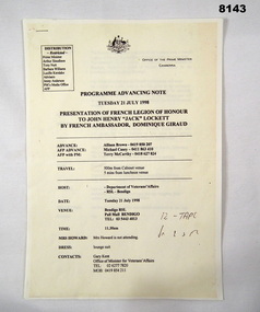
Programme - PRESENTATION OF FRENCH LEGION OF HONOUR, Office of the Prime Minister, pre 21.7.1998
This is a copy of the original produced by the Office of the Prime Minister of Australia. The presentation of the French Legion of Honour to John Henry Lockett (Jack) by the French Ambassador His Excellency Dominique Giraud was to be held in the main Hall of the Soldiers Memorial Institute Pall Mall Bendigo on 21.7.1998. (Now Bendigo Military Museum) Refer Cat No 8144 re the program on the day, Cat No 8145.10P for photographs.Program copy of original, 3 pages stapled, all print in black on yellow background. Details the presentation of the French Legion of Honour by the French Ambassador Dominique Giraud to John Henry Lockett on 21 July 1998. Covers arrivals, guests, timings, dress, speeches with the main guest being the Australian Prime Minister Mr John Howard.brsl, smirsl, french, legion of honour -
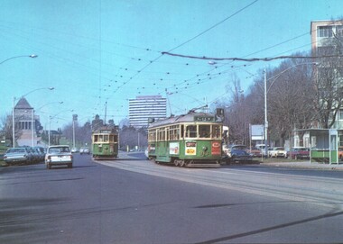 Melbourne Tram Museum
Postcard - St Kilda Road, with W class trams and the Shrine of Remembrance, National View by Murfett Publishing, 1970s
Postcard - St Kilda Road, view looking south at the Shrine of Remberance, BP House and on the far right part of the now demolished Prince Henry's Hospital. Trams in the view are W2 345 (Carnegie Route 4) and SW6 913 (City, Route 4). Tram 813 has adverts for Coffey Ford and T&G insurance along with others. The driver of 913 has his cap on an angle.Yields information about St Kilda Road around the Shrine, c1970 and tram services.Postcard colour - St Kilda Road, with W class trams and the Shrine of Remembrance - National View - Murfett publishingtrams, tramways, st kilda road, w2 class tram, sw6 class tram, tram 913, tram 345, shrine of remembrance -
Whitehorse Historical Society Inc.
Article, Water woes, 1993
Problems with drainage systems in Nunawading would take 32 years to complete at the rate they were being fixed.Problems with drainage systems in Nunawading would take 32 years to complete at the rate they were being fixed. Residents in Irene Crescent and Wattle Valley Road will be charged and others will pay for new drains throughout the city.Problems with drainage systems in Nunawading would take 32 years to complete at the rate they were being fixed. city of nunawading, ward, kelvin, irene crescent, mitcham, wattle valley road, mitcham, drainage -
Whitehorse Historical Society Inc.
Article, Inaugural meeting of the Nunawading and District Historical Society, 1965
Article refers to address given by Chief Librarian, Box Hill and Doncaster Regional Library, H.C. LewisArticle refers to address given by Chief Librarian, Box Hill and Doncaster Regional Library, H.C. Lewis at the meeting in Methodist Hall, Whitehorse Road, Nunawading. Ref: Nunawading Historical Society Minute Book No 1.Article refers to address given by Chief Librarian, Box Hill and Doncaster Regional Library, H.C. Lewis nunawading historical society, lewis, h.c., box hill & doncaster regional library -
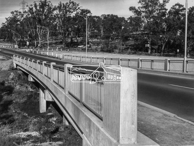 Eltham District Historical Society Inc
Photograph, Shire of Eltham, New bridge over the Plenty River, Lower Plenty, Nov. 1966
Newly constructed single span bridge on Main Road (now Lower Plenty Road) crossing the Plenty River at Lower Plenty. Site of Heidelberg Golf Club and Lower Plenty Hotel in the background. This was the boundary between the Shire of Eltham and the City of Heidelberg.This photo forms part of a collection of photographs gathered by the Shire of Eltham for their centenary project book ,"Pioneers and Painters: 100 years of the Shire of Eltham" by Alan Marshall (1971). The collection of over 500 images is held in partnership between Eltham District Historical Society and Yarra Plenty Regional Library (Eltham Library) and is now formally known as 'The Shire of Eltham Pioneers Photograph Collection.' It is significant in being the first community sourced collection representing the places and people of the Shire's first one hundred years.Digital imagesepp, shire of eltham pioneers photograph collection, lower plenty, bridge -
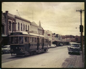 Ballarat Tramway Museum
Photograph - Colour Photograph/s, Jim Seletto, c1958?
Colour photograph of SEC 43 in bound along Main St. ex Mt. Pleasant. Photograph prior to 1960. Photo looking towards the intersection of Main and Bridge St. Tram has the destination of Gardens via Drummond St. Nth.ballarat, mt pleasant, main st, tram 43 -
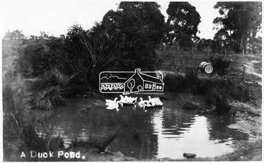 Eltham District Historical Society Inc
Photograph, Tom Prior, A Duck Pond, c.1900
The location was Fernie Hill where Ivy Reynolds's mother was born, over from Mr Traill's property at the corner of Reynolds and Main Road, Research - used to be called 3 Chain Road, now renamed Gumtree Road. The old Yarra River bed goes through here at top of hill in Gumtree Road. Gravel from this location was used for the driveways in Government House.This photo forms part of a collection of photographs gathered by the Shire of Eltham for their centenary project book,"Pioneers and Painters: 100 years of the Shire of Eltham" by Alan Marshall (1971). The collection of over 500 images is held in partnership between Eltham District Historical Society and Yarra Plenty Regional Library (Eltham Library) and is now formally known as the 'The Shire of Eltham Pioneers Photograph Collection.' It is significant in being the first community sourced collection representing the places and people of the Shire's first one hundred years.Digital image 4 x 5 inch B&W Negsepp, shire of eltham pioneers photograph collection, eltham, duck pond, reynolds prior collection, pond, fernie hill, gumtree road, research (vic.) -
Glen Eira Historical Society
Article - Rockbrook Road, 16, St Kilda East
Two items about this property and environs: 1/Photocopy of a typed document, dated 29/02/1988, written by Hilary Bullock and Rosalind Landells of Brighton Historical Society, detailing the history and owners and occupiers of 16 Rockbrook Road, St Kilda East. Accompaying it is a handwritten working note of same with the information coming from 'Sand Swamp and Heath'. 2/A Wikipedia article with Bibliography of James Service, joint owner of Rock Brook, St Kilda East (article last modified 01/10/2009).rockbrook road, 'rock brook', gardiner william, st kilda east, the argus, stevenson william, hotham street, caulfield, taylor percy w., balaclava road, service street, brosnan john c., glen eira road, service james, brosnan l.c. mrs., brosnan m miss, vafeas g., bullock hilary, landells rosalind., industrial workers, merchants, commerce, sports and recreations, journalists, newspapers, roads and streets, houses, premiers, parliamentary representatives, land subdivision, house names -
Glen Eira Historical Society
Document - Carnegie Methodist Church, Neerim Rd, 252- 254, Carnegie
Booklet Carnegie Methodist Church 70th Anniversary Back to Carnegie 1956. Includes history information and Office Bearers of the Church with sketch 130mm x 65mm. Booklet Carnegie Methodist Church, 80th anniversary Back to Carnegie 1966 includes a brief history of the Church. Includes sketch 130mm x 65mm. Booklet Neerim Road (Carnegie) Uniting Church of Australia Formerly Carnegie Methodist Church. Centenary 1886 – 1986 Includes order of Morning Service. Includes exterior photograph 150mm x 80mm.carnegie, carnegie methodist church, schools, parsonages, rosstown state school, churches, sunday schools, methodist church, religious groups, oakleigh circuit, uniting church, methodist circuit, neerim road, williams h. j. rev, wells w. p. rev, jamison mr., wade mr, webb mr, baker mr., wilton mr., pearson mr., barrett mr., evans mr, stables, edgar w. h., secomb w. e. rev, tratham j. rev, rowse j. w. rev., alday t. rev, turner e. rev, leslie j. rev., adamson t. rev., palamountain wid. rev, holtham w. h. rev, wellard w. e. rev, rankin f. j. rev, bridgborn w. c. rev, tregear g. rev., newbegin f. w., harris h. r rev., phillips c. r. rev., wise mr., barnett mr., woods mr., phillp. mr., retallick mr., amos mr., long mr., ellis mr., ralph mr, walker mr., butler mr., snell mr., chisholm mr., bruce mr., sparlio mr., beecham mr., spencer mr., pascoe mr, archer mr., watson mr., arneil r., harwood charles, dunn j. t., gordon r., bracher l. a., johnson a. mrs., welch don, rose frank, hussack francis, marshall noreen, newitam ron, watson lawry, mathias rex rev, churchward a. rev, wallace g. e., smith jack mrs., byron mrs., daniels mrs, williams h. j. mrs, green anne, huffer n. mrs., cawthorn h. a., hunt a. w., kemp w. r. rev, addinsall c. roy, harrison w. r. rev, addisall c. r. mrs, addisall joan, bone bob, johns mrs., gordon e., rodgers keith, govers mrs, watters graham, wesleyan chilf, wesley hall carne, mcconachy r. s. rev, williams les. mrs., festivals and celebrations, mac rae chris, moorhead k. h. rev, shepparson avenue, james street, glenhuntly, toolambool road, edgar w. h., secomb w. e., hillis geoff, barners peter, moyle bruce, barry warrick, kilgour alex, green kevin rev, mcmullin bruce, gaylard heather, byard trevor rev, wells w. p. rev, trathen j, rouse j. w, alday t, turner e, leslie j., adamson t, palamountain w. j., secomb w. e., holtham w. h, hooper r. e., lloyd g., tregear g., shackelly e, rankin f, tonkin e, churchward s, harris g. c, beckett r., hamlett j. b., camilatos p., macrae jenny -
Glen Eira Historical Society
Drawing - St Aloysius Church, Caulfield
Two Photocopies of a pamphlet from May 1924 signed A. L Kenny about the newly built St Aloysius Catholic Church on Balaclava Road, Caulfield. The pamphlet features a detailed description of the architectural features of the interior and exterior, including Gothic spire and nuns tubrine. The pamphlet is across 6 A4 pages for both copies. Included within are several photographs, of varying sizes, of the interior and exterior of the church, a photograph of the architect Bart Moriarty and an illustration of the proposed Presbytery. Within is a list of benefactors, their gifts to the church and the value of each gift.st aloysius’ church, o’ brien fr., parish of caulfield, returned soldiers and nurses caulfield, balaclava road, altar society, moriarty bart, caulfield., kenny a. l., popular summer girls, kehoe miss, rattray mrs, power mr., power mrs., kelly mrs., gleeson t. mr., gleeson t. mrs, foley m., guilfoyle, beth mr., murphy i. l mrs., killorn mr., walsh mr, radcliffe mrs., klaer d. miss, hogan a. miss, hennessy lady, pilkington m. miss, pilkington e. miss, connolly mr., hogan brothers, o’ loughlin count, o’ loughlin mrs, levers miss, burke t. m. mr, burke t.m. mrs, confoy t. j. mr, confoy t. j. mrs., harrington mrs., eccles e. mr., eccles e. mrs., dorgan d. mr, dorgan d. mrs, wren j. mr, wren j. mrs., kisby mrs, charlton h. miss, foulshan w mr., pilington mrs, mcgrath m. mr., mcnamara mrs, cornack mrs., connolly e. a. mr., malone mrs., wharton mr., wharton mrs., donoghue d. mr, foulsham w. mrs, sweeney p. mr., sweeney p. mrs., adams h. m mr, adams h. m mrs., vaughan d. e. mr, vaughan d. e. mrs., mclennan mrs, morgan myra miss, boland catherine miss, hennessy n. mr., casey s.p. mr, casey s.p. mrs., mclntyre e. miss, mannion mr., bennett mrs., drummond mrs., lectie mrs., catholic church, churches, gothic (revival) architecture, architectural features, architectural styles, architects, clergy residences, church furniture, religious ceremonies, nuns, communion rails, altars, fonts, pulpits, pews, stained glass, windows, organs, sculpture, cast iron work -
Glen Eira Historical Society
Map - Gardenvale Road, 11, Caulfield South
A one page typed letter from Equity Trustees to S P Simmonds Estate Agent, dated 12/12/1963, requesting a valuation of the property at 11 Gardenvale Road, Caulfield South. The file also includes a three page typed valuation of the property dated 19/12/1963. It provides details of the property and includes a hand drawn plan (75mm x 100mm) showing measurements of the block. The file also includes one page of undated, unattributed, handwritten working notes for the purpose of the valuation.redapple r r, redapple joseph, redapple rebecca rachel, gardenvale road, caulfield south, land values, brick houses -
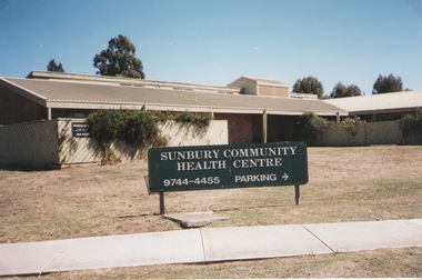 Sunbury Family History and Heritage Society Inc.
Photograph, Elwyn Davis, Former Sunbury Community Health Centre, March 2002
The first Sunbury Community Health Centre was built on the corner of Horne Street and Gap Road in a temporary building. As result of further funding in 1974, a permanent building was erected and opened in 1981 and operated from that site until 2000 when it was relocated into a larger and more modern building on the former Sunbury Primary School site in Macedon Street to accommodate Sunbury's expanding population and needs.It now operates under the name of Sunbury and Cobaw Community Health Centre. The old building was demolished and replaced with a fast-food outlet.A non-digital coloured photograph of the Sunbury Community Health Centre showing the notice board displayed in the front giving phone details and parking area.sunbury community health centre, health centres, gap road, horne street -
 Eltham District Historical Society Inc
Slide, Construction of Eltham Town Park, 25 Jul 1973
Construction of Eltham Town Park; landscape has been scupltured and lakes formed. View looking up towards intersection of Bridge Street with Main Road. On the high side of Main Road is Garni Burges former home at the corner of Bridge Street then further to the left the former bakery on the corner of York Street. On the opposite corner is the feed store now the site of Le Pine Funerals. The park was later renamed Alistair Knox Park.35 mm colour positive transparency Mount - Agfacolor Service (Blue)Memorial Park 25 July 1973eltham, main road, alistair knox park, eltham town park, shillinglaw cottage, bridge street -
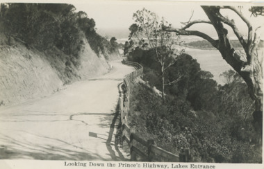 Lakes Entrance Historical Society
Postcard - Princes Highway Lakes Entrance, 1930 c
Princes Highway Jemmys Point showing gravel road post and rail fence freshly excavated cliff with Entrance glimpses in distance Lakes Entrance Victoria. Also a second black and white postcard taken much later of Princes Highway Jemmys Point Lakes Entrance showing sealed road with double lines in centre, post and rail fence, Entrance in distance. Donor Susan Samuel 2 January 2015. Number 04204.1Black and white postcard taken of Princes Highway Jemmys Point showing gravel road post and rail fence freshly excavated cliff with Entrance glimpses in distance Lakes Entrance VictoriaLooking Down the Princes Highway Lakes Entrancecivil engineering, roads and streets, fences -
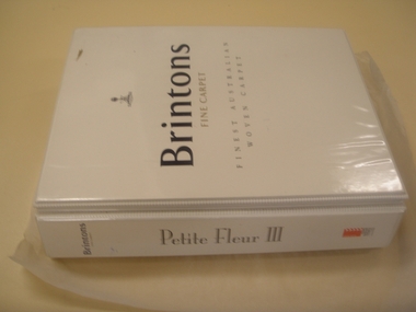 National Wool Museum
Book, Carpet Sample, Petite Fleur III
A sales book for the Brintons' design range 'Petite Fleur III' acquired when Brintons' Fellmonger Road factory closed.W7192 W7192_2 Page 1 of a history of Brintons Carpets. Page 2 of a history of Brintons Carpets. A list of catalogues/items in the Brintons Collection donated after closure of Fellmongers Road factory in July 2008.Brintons Fine Carpets Finest Australian Woven Carpets Petite Fleur IIIfurnishing, brintons australia pty ltd brintons pty ltd (geelong) brintons ltd (uk), sales -
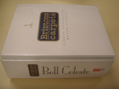 National Wool Museum
Book, Carpet Sample, Bell Celeste
A carpet sales book for the Brintons' design range 'Bell Celeste' acquired when Brintons' Fellmonger Road factory closed.W7195 W7195_2 Page 1 of a history of Brintons Carpets. Page 2 of a history of Brintons Carpets. A list of catalogues/items in the Brintons Collection donated after closure of Fellmongers Road factory in July 2008.Brintons Carpets Finest Australian Woven Carpets Bell Celestefurnishing, brintons pty ltd (geelong) brintons ltd (uk) brintons australia pty ltd, sales, samples -
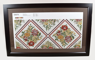 National Wool Museum
Card, Design
A Brintons carpet design card printed the same month that the Fellmongers Road factory closed down. Acquired on the closure of the factory.W7201.1 W7201.2 Page 1 of a history of Brintons Carpets. Page 2 of a history of Brintons Carpets. A list of catalogues/items in the Brintons Collection donated after closure of Fellmongers Road factory in July 2008.D6679 Brintons PTY - Boardroom QUALITY: Sp Ax - 12bu LOOM WIDTH: 200cm STRAIGHT LENGTH REPEAT: 467 ROWS CARD WIDTH AND MATCH: 276 ENDS STRAIGHT MATCH Design ID: D6679 Design Size: 3ft 3.43in by 3ft 2.92in Ends*Rows: 276*467 Quality: 7*12 per inch Match: 233 row dropbrintons australia pty ltd brintons pty ltd (geelong) brintons ltd (uk), carpet -
Whitehorse Historical Society Inc.
Map, Environment effects statement, 1/03/1979 12:00:00 AM
Diamond Creek-Ringwood study: Planning Scheme reservations and zones with recommended concept.Diamond Creek-Ringwood study: Planning Scheme reservations and zones with recommended concept. City of Nunawading: section north of Canterbury Road. Scale 1:25,000 metric. Map B with drafting ref. no. 145Diamond Creek-Ringwood study: Planning Scheme reservations and zones with recommended concept. city of nunawading, land use, melbourne metropolitan planning scheme -
Bendigo Historical Society Inc.
Photograph - ROAD WORKS
DVD. Road works. Country Roads Board. Victoria. -
 Whitehorse Historical Society Inc.
Photograph, Alterations to roads
Coloured photo of alterations to Canterbury Road/Boronia Roadcanterbury road vermont, boronia road vermont, roadworks -
 Whitehorse Historical Society Inc.
Photograph, Alteration to Roads
Coloured photo of alterations to Canterbury Road and Boronia Roadcanterbury road vermont, boronia road vermont, roadworks -
Glen Eira Historical Society
Article - Third Church of Christ, Scientist, Elsternwick
5 Articles about the building which used to be Third Church of Christ, Scientist Elsternwick. The first one is an article from leader newspaper dated 27 July 2010 discussing the plan to convert former Christian Science Church and latterly Buddhist organisation into apartments. The second article is from Leader Newspaper dated 10 August 2010, commenting on disruptions that might occur with redevelopment. Third article is from Caulfield Leader, 07/09/2010. The article is on continuing discussion on proposed plans for the building which previously was a historic church. Also mentioned, residence’s concern and complains about the plan. The fourth article from Caulfield/ Port Phillip Leader, 24/05/2011, mainly talks about similar development at 221 -229 Glen Huntly Road. It also touches the subject of 233 – 147 Glen Huntly Road and 12 – 14 Ripon Grove as well. It is written that VCAT allowed the development of 10 storey building after overturning council decision. The fifth article is from Melbourne Bayside Weekly, 28/03/2012. It talks about the history of The Church of Christ, Scientist and about the old church building that still stands.ripon grove, gordon street, contour consultant, glen eira, historic sites, buddhist clubs and associations, elsternwick, glen huntly road, church, wait peter, wright kristen, kate ms, sinclair street, soka gakkaii, local government, local officials and employees, mc combie street, david street, ward camden, holden lars., connellan rose, connellan cathlea, connellan marilyn, third church of christ scientist elsternwick, heritage victoria, victorian civil and administration tribunal, eddy mary baker, clifton andrew, sammon jason, di paolo lucy, robinson andrew, ling jenny, church of christ scientist