Showing 124163 items
matching main-road
-
 Melbourne Tram Museum
Postcard - Nu-color-Vue - St Kilda Road, Shrine of Remembrance W2 453, Nucolorvue Publishing, 1970s
Postcard - image looking south in St Kilda Road, with the Shrine of Remembrance and BP House in the view. Tram W2 453 (City Route 6) and SW6 945 (Camberwell Route 72) has stopped at the safety zone tram stop.Demonstrates an iconic Melbourne image, St Kilda Road, the Shrine and W class tramsPostcard colour - serrated edge, Nu-color-Vue - St Kilda Road, Shrine of Remembrance W2 453, ML 156, NCV 1381 Divided back.trams, tramways, w2 class tram, shrine of remembrance, tram 453, st kilda road, tram 945 -
 Southern Sherbrooke Historical Society Inc.
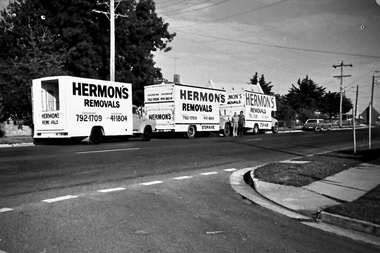
Photograph - Set of photos pertaining to Hermon's Removals, c. 1980s
Set of photos from c. 1980s pertaining to Hermon's Removals. William (Bill) Hermon Junior established a furniture removals business in 1935. Their depot was on the corner of Main Rd and Snodgrass St, Pakenham. When Bill's younger sons Ken and Ron, acquired the business in 1994 the business was renamed Hermon's Rainbow Removals, which remains in operation today. 1. Photograph of 3 trucks from Hermon's Removals on Main Road, Pakenham, down near McGregor Rd. Their depot was on the corner of Main Rd and Snodgrass St, Pakenham. 2. Photograph of one of Hermon's Removal trucks at Pakenham. 3. A photograph featuring three of Hermon's Removal Trucks lined up on a suburban street. 4. A photograph featuring Bill Hermon (second from the right of picture) and his sons, Ron, John and Ken. -
 Ruyton Girls' School
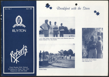
Newsletter, Ruyton Reports, 1990
The Ruyton Reporter (formerly known as Ruyton Reports) captures the essential Ruyton Girls' School experience for the broader school community. It has been produced since 1986.The record has strong historic significance as it pertains to one of the oldest girls' school in Victoria, Australia. Ruyton was founded in 1878 in the Bulleen Road, Kew, home of newly widowed Mrs Charlotte Anderson (now High Street South). Thus, the record can be used as a reference example for research into Victorian school history. It also gives insight into the types of activities and events undertaken at Ruyton Girls' School during the period of its production. The record's significance is further enhanced by its exceptionally well-documented provenance, having remained the property of Ruyton Girls' School since its production.Black and white newsletter printed on paper with staple binding. 8 pages.Front Page: Vol. 5 No. 1 April, 1990 / R / RECTE ET FIDE LITER / RUYTON / 1878 - 1988 Reports / From Ruyton Girls' School / 12 Selbourne Road, Kew. 3101 / Telephone (03) 819 2422 / Breakfast with the Stars / L. to R. Peter Hudson, Luke Docking & Benny Lewis (Westside Saints) Paul / Hudson (Hawthorn F.C.), Tony Charlton / Tony Charlton with Tim Watson (Capt. Essendon F.C.) / Aerobics Display /ruyton girls' school, ruyton, school, students, newsletter, ruyton reports, ruyton news, kew, victoria, melbourne, girls school -
 Whitehorse Historical Society Inc.
Map, Aerial photograph, c1950
Arial photo of Vermont South and Burwood East, Middleborough Road, Burwood Highway, Springvale Road, Highbury Road and environs.Aerial photo of Vermont South and Burwood East, Middleborough Road, Burwood Highway, Springvale Road, Highbury Road and environs.Arial photo of Vermont South and Burwood East, Middleborough Road, Burwood Highway, Springvale Road, Highbury Road and environs.vermont south, burwood east, aerial photographs -
 Camberwell Historical Society
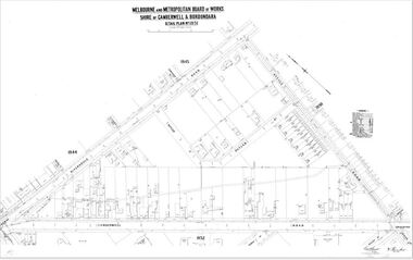
Map (Item) - MMBW map, Melbourne and Metropolitan Board of Works, Melbourne and Metropolitan Board of Works - Shire of Boroondara and Camberwell - Detail Plan no. 1851, July 1904
Lithographer JEM, exd. JWD, July 1904, no. 81, 40P. 15W.melbourne and metropolitan board of works, map, camberwell, cartography -
 Stawell Historical Society Inc
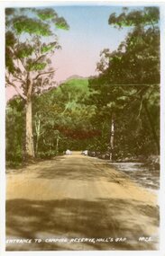
Postcard, Camping Ground Entrance at Halls Gap in the Grampians -- Postcard
Entrance to Camping Ground Halls Gap The Grampians.Colour photo of a tree lined dirt road with an entrance way at the end of the road. Very tall trees line the road.Entrance to camping reserve, Halls Gap. halls gap grampians -
Canterbury History Group
Photograph - Street view of shops on the corner of Canterbury Road and Balwyn Road, Jan Pigot, 1994
Coloured photograph of the street view of Carnell's Furniture shops at 173 Canterbury Road at the corner of Canterbury Road and Balwyn Road.canterbury, canterbury road, shops, balwyn road -
Canterbury History Group
Photograph - Street view of Canterbury Road showing the Post Office and Maling Road, Jan Pigot, 27/03/1993 12:00:00 AM
Coloured photograph of the street view of Canterbury Road and the T intersection of Maling Road and the Post Office at No.206 Canterbury Road.canterbury, canterbury road, post offices, railway lines -
 Greensborough Historical Society
Photograph, Plenty River Bridge Greensborough, 1910c
Early photograph of Main Street bridge over the Plenty River, taken around 1910. Quirk's Tailor shop is seen in the background and a horse and cart coming down the road. The road appears unsealed. Rampant blackberries can be seen growing around the bridge abutments. Part of a collection of photographic enlargements of Greensborough sites.Black and white enlargement of photographic imagemain street bridge, main street greensborough, plenty river greensborough, quirk's tailor shop, blackberry, mckenzie bridge -
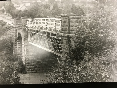
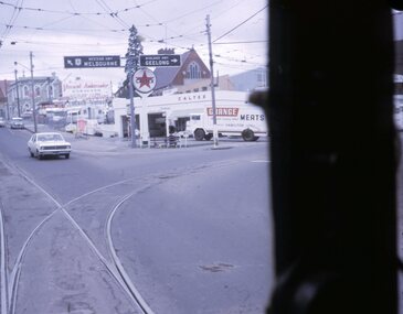
 Melbourne Tram Museum
Photograph - Black and White, W Class Tram 220 - Newspaper photo 1924, 5-1-1924
Image shows a 1924 newspaper photo of one of the new W Class trams in service. The photo caption gives details of the tram including its length. It has the destination of St Kilda Road.The W Class Trams were a highly successful design of trams for Melbourne. W 220 was the second W Class tram built. Photo was taken in 1924 showing this tram with St Kilda Road on the destination board. Note there is no destination route number box.tramways, trams, st kilda road, tram 220, w class trams -
Lakes Entrance Historical Society
Photograph - View from Jemmys Point, 1926
Also two other black and white photographs taken along the road to Jemmys Point Bullock Island in background 05002.1 and 05002.2 showing trees along roadside 7 x 11.5 cmBlack and white photograph looking uphill at Jemmys Point Road showing post and rail fence on lower side and steep roadside cutting on upper side Lakes Entrance Victoria waterways, roads and streets, islands -
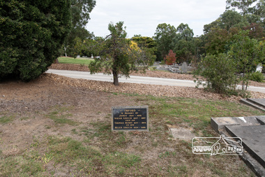 Eltham District Historical Society Inc
Photograph, Peter Pidgeon, Orford family graves, Eltham Cemetery, Victoria, 5 April 2021
One of Eltham's earliest settlers was James Orford. Born 1804 in Bedfordshire, the son of George, a carpenter and Lydia Barret, he and wife Sarah Amelia nee Moull (1807) arrived as Assisted Immigrants aboard the ship, ‘Orestes’, November 28, 1839 accompanied by their children, George (14), Mary Ann (11), and James (2). Originally settling in New South Wales, daughter Sarah Amelia was born at Braidwood in 1843 and son, Thomas Henry at Pambula in 1847. James was a carpenter who is known to have built the original gates to Eltham Cemetery. He died in 1869. Around 1890, his son Thomas Henry Orford was living in Pitt Street. Following the death of his wife Helen in 1899, Thomas was appointed by Joseph Panton to look after ‘Panton Park’, a 429-acre bushland property at the fork of Reynolds and Laughing Waters Roads, extending down to the Yarra River. His work entailed ringbarking the manna gums on the property to clear the land for pasture. Thomas lived in a slab hut with his son Ernie, who helped with the work. When Gordon Lyon purchased Panton Park in 1908, Thomas then worked for Lyon at both Panton Park and at ‘Banyule’, Lyon's stud farm at Heidelberg. In 1915 Lyon gave Thomas six acres of land in Reynolds Road with a two-roomed cottage. Thomas died in 1944 and is buried in Eltham Cemetery with his wife and his parents. Another of James Orford's sons was James Matthias Orford. He tried to grow food on land at the end of Laughing Waters Road, but without success. Reputedly the Wurundjeri taught him to swim. He was once imprisoned; when his friend Constable Lawlor invited him to inspect the new bluestone lock-up, Lawlor locked him in and wouldn't release him until he was promised two gallons of beer! ORFORD In Memory Of James 1804 -1869 Sarah Amelia 1807 - 1897 Their son Thomas Henry 1847 - 1944 His wife Helen Amelia 1854 - 1899Born Digitaleltham cemetery, gravestones, helen amelia orford, james orford, sarah amelia orford, thomas henry orford -
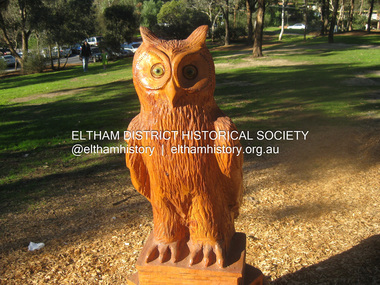 Eltham District Historical Society Inc
Photograph, Fay Bridge, Owl, chainsaw sculpture by Leigh Conkie, 21 July 2013
Leigh Conkie is a well known Eltham artist who creates a wide variety of subjects in wood modelled by chainsaw at his home in Main Road. Location unknownfay bridge collection, chainsaw sculpture, leigh conkie, 2013-07-21, sculpture -
 Eltham District Historical Society Inc
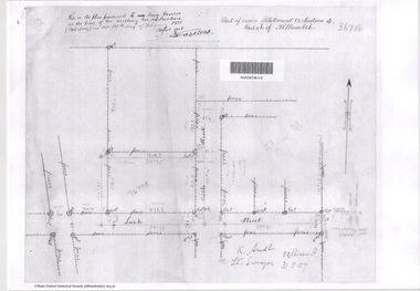
Document - Photocopy, Survey Fleld Notes of Part of Crown Portion 13, Section 4 at Eltham, Parish of Nillumbik, County of Evelyn, 31 May 1907
Portion of land east of Main Road and north of Luck Street bounded by Bible Street Application 36708 K. Arndt, Licensed Surveyor, 31 May 1907application 36708, bible street, eltham, luck street, main road, map, survey plan -
 Eltham District Historical Society Inc
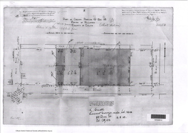
Document - Photocopy, Survey Fleld Notes of Part of Crown Portion 12, Section 4 at Eltham, Parish of Nillumbik, County of Evelyn, 12 October 1910
Portion of land bounded by: Main Road, John Street, Bible Street, Pitt Street Application 38858 K. Arndt, Licensed Surveyor, 12 August 1910application 38858, bible street, eltham, john street, main road, map, pitt street, survey plan -
 Eltham District Historical Society Inc
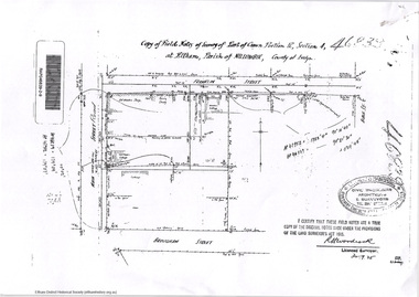
Document - Photocopy, Survey Fleld Notes of Part of Crown Portion 12, Section 4 at Eltham, Parish of Nillumbik, County of Evelyn, 30 September 1925
Portion of land bounded by: Main Road, Franklin Street, Bible Street, Brougham Street Application 46839 R. Woodcock, Licensed Surveyor, 30 September 1925application 46839, bible street, brougham street, eltham, franklin street, main road, map, survey plan -
 Eltham District Historical Society Inc
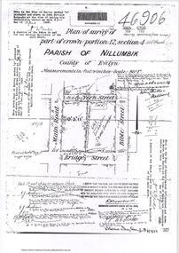
Document - Photocopy, Survey Fleld Notes of Part of Crown Portion 12, Section 4 at Eltham, Parish of Nillumbik, County of Evelyn, 18 March 1926
Portion of land bounded by: Main Road, York Street, Bible Street, Bridge Street Application 46906 R.H. Woodcock, Licensed Surveyor, 18 March 1926application 46906, bible street, bridge street, eltham, main road, map, survey plan, york street -
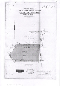 Eltham District Historical Society Inc
Document - Photocopy, Survey Fleld Notes of Part of Crown Portions 12 & 13, Section 4 at Eltham, Parish of Nillumbik, County of Evelyn, 6 May 1929
Portion of land bounded by: Main Road, York Street, Diamond Creek, Swan Street Application 48223 P.N. Guy, Licensed Surveyor, 6 May 1929application 48223, diamond creek (creek), eltham, main road, map, survey plan, swan street, york street -
 The Beechworth Burke Museum
Audio - Oral History, Jennifer Williams, Evelyn Jensen, 13th April 2000
Miss Evelyn Jensen was born in 1908 near Mytleford Road in Beechworth. Miss Jensen was a twin but she also had twelve brothers and sisters. Miss Jensen went to school when she was nine years old but did not enjoy it. Her father was a nozzleman and had a role in finding and collecting gold. More specifically, a nozzleman operated a steel barrel with an interchangeable brass nozzle that sprayed high pressure water onto rock and similar surfaces. This broke down the surface for gold to be found. Unfortunately, when he began most of the gold was already gone. Miss Jensen's mother died when Miss Jensen was sixteen. As a result, Miss Jensen had to take care of the children and run the house. This included looking after a few months old baby. Her father was away at work most days so all of the responsibility fell on her. Her grandmother was present but she was too old to help Miss Jensen. Miss Jensen and her family lived a very long way from the main town and often had to carry kerosene tins full of water half a mile to their house. This was because they have no access to water at their home. This lack of water also meant they had to either bathe in the creek or carry the water back home for a bath. On wash day, they washed their clothes in the creek too. Miss Jensen never married but continued to provide for her family. She spent her days gardening and cooking. They did not have much money so gardening was a way that they provided food for themselves. This oral history recording was part of a project conducted by Jennifer Williams in the year 2000 to capture the everyday life and struggles in Beechworth during the twentieth century. This project involved recording seventy oral histories on cassette tapes of local Beechworth residents which were then published in a book titled: Listen to what they say: voices of twentieth century Beechworth. These cassette tapes were digitised in July 2021 with funds made available by the Friends of the Burke.Miss Jensen's oral history is significant because it demonstrates the struggles of living remotely during this early part of the twentieth century. When Miss Jensen's mother died, she had to take on a lot of responsibility and did not have much support. This history sheds light on these struggles of being a young caregiver but it also gives details on how large families lived in isolated places. An example of this is the way that Miss Jensen often had to do the washing in the creek because that was the only place there was running water. In addition, Miss Jensen's story is significant because her father was a nozzleman. It indicates one of the processes was used to find gold. This oral history account is socially and historically significant as it is a part of a broader collection of interviews conducted by Jennifer Williams which were published in the book 'Listen to what they say: voices of twentieth-century Beechworth.' While the township of Beechworth is known for its history as a gold rush town, these accounts provide a unique insight into the day-to-day life of the town's residents during the 20th century, many of which will have now been lost if they had not been preserved.This is a digital copy of a recording that was originally captured on a cassette tape. The cassette tape is black with a horizontal white strip and is currently stored in a clear flat plastic rectangular container. It holds up 40 minutes of recordings on each sideEvelyn Jensen /mytleford road, beechworth, three mile creek, three mile beechworth, twin, nozzleman, goldrush, gold rush, work, mother, young mother, children, siblings, baby, grandmother, father, isolation, bush, water, watertanks, kerosene tins, wash day, bath day, creek, gardening, provide, poor, money, oral history, twentieth century, recording, story -
 University of Melbourne, Burnley Campus Archives
Photograph - Black and white print, Camberwell City Council, Two Suburban Houses, 1930
Note by T.H. Kneen 24 June 1992, "B91.424 and 425 are paired to show effect of lowering road level and consequent adjustment to access to the houses photographed. The handwriting is Mr. Jessep's."Black and white photograph. The front of the same 2 suburban houses as B91.424. The nature strip has been lowered to the same level as the road and each has a wooden paling front fence.suburban house, a.w. jessep, landscaping -
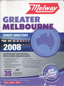 Eltham District Historical Society Inc
Book, Melway Greater Melbourne street directory 2008 : including Geelong, Phillip Island, Healesville, Kinglake, Gisborne, Lorne, Bacchus March, Wallan, Bellarine & Mornington Peninsulas; Edition 35, 2008, 2007
Edition 35. 2008 Coloured detailed maps accessed by a street or location index. Cover: Totally revised and updated with over 730 additional street listings, new maps extending the Gisbourne and Wallan areas. The most comprehensive public transport routes information - train, tram, bus, walking and bicycle tracks. Eastlink fully detailed, Victoria Racing Club, Flemington enlargement, GPS compatible WGS/MGA Grid displayed, This editon is available in LARGE PRINT format, new eway electronic street directory now available - www.melway.com.au Special feature: New Hierachy of Roads Street directory, coloured maps, indexes, 1201 pagesstreets,roads,melbourne,map,melway -
 Ballarat Tramway Museum
Slide - 27 mm sq slide/s - set of 7, Lilian Butler, Mt Pleasant line, Sep. 1971
Yields information about the streetscapes of Stones Corner to Mt Pleasant route and in particular buildings and people that crewed the trams.Set of seven Colour 27 x 27 mm slide in a Kodachrome cardboard mount. .1 - Tram turning onto the Mt Pleasant line at Stones Corner - Bridge St, Main Road .2 - Main Road looking south with Inland Body Works building on the left and Ampol Service Station .3 - Mt Pleasant terminus with the butcher shop on the left and the diary on the right - shows the terminating tram track .4 - Conductor changing pole. .5 - Putting pole on the overhead .6 - Conductor (D O'Leary - No. 38) standing in front of tram and Motorman or driver (N. Hall - No. 43) .7 - ditto with number visible. See Reg item 3425 for crew lists. Slide mount date September 1971. Photo from the collection of Lilian Butler.ballarat, tramways, trams, stones corner, main road, mt pleasant, crews, drivers, conductors, trolley poles, tram 41 -
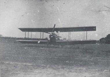 Phillip Island and District Historical Society Inc.
Photograph, 1920
One of a collection of over 400 photographs in an album commenced in 1960 and presented to the Phillip Island & Westernport Historical Society by the Shire of Phillip IslandPhotograph of an early Bi Plane landing on the site of the Main Garage, Thompson Avenue, Cowes - 1920local history, photography, aeroplane, black & white photograph, air transport, bi planes, john jenner, bryant west -
4th/19th Prince of Wales's Light Horse Regiment Unit History Room
Booklet, The Snelling Printing Works Pty Ltd, Tank Training Vol II Part 1 Pam No 1 Tank Gunnery, 1938
A soft covered booklet covering various aspects of tank gunnery including main armament and MGtank gunnery -
Glenelg Shire Council Cultural Collection
Photograph - Photograph - Main Breakwater construction, Portland, n.d
Port of Portland Authority Archivesport of portland archives, aerial photography, portland harbour -
Port Melbourne Historical & Preservation Society
Document - Specifications, Main drain, west branch, Evans Street to Esplanade East, Port Melbourne, Arthur Victor Heath, Town Clerk et al, 14 Mar 1893
Specifications for the construction of main drain west branch 1893 (together with plan attached - refer 75.2)A.V. Heath (Town Surveyor):J.J. Bartlett (Mayor)engineering - canals and drainage, arthur victor heath, town clerks, james john bartlett, mayors -
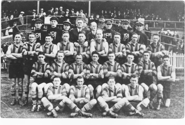 Port Melbourne Historical & Preservation Society
Photograph - Port Melbourne Football Club, 1932
Black and White unframed photo of the Port Melbourne Football Team of 1932. Shows Main GrandstandOn the reverse side is the surnames of all the players shown in the photo. Also the year 1932sport - australian rules football, barnett, a garbutt, hall, smith, griffin, clements, sharp, ashton, tuite, payne, murphy, alldridge, perrett, rees, lego, atkinson, joe garbutt, rusden, bedford, plumridge, lovett, lowrie, julier, tommy lahiff, barnes, hurley, garlepp, bolman, keating -
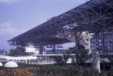 Robin Boyd Foundation
Slide, Robin Boyd, 1970
Robin Boyd was appointed Exhibits Architect for the Australian Pavilion at Expo ‘70 in Osaka and travelled to Osaka several times in 1969-1970. Boyd designed the innovative Space Tube, which had over 25 exhibition boxes, projecting from it. Amongst the topics covered were Australian scientific innovation (including brain research, immunology, Antarctic research, Snowy Mountains Hydro-Electric Power Scheme, rainmaking, and the night sky), Australian sport, house interiors, car manufacturing, Australian music and art, and Japanese-Australian relations.Colour slide in a mount. Main Pavilion, Osaka Expo '70, Japan. (Architect: Kenzo Tange.)Made in Australia / 2 / MAY 70M3 / 27 (Handwritten)expo 70, osaka, robin boyd, slide -
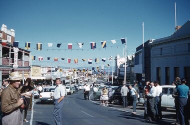 Stawell Historical Society Inc
Photograph, Ian McCann, Parades
Main Street Stawell with Flags across the Street showing the Bull & Mouth Hotel. Easter 1962parades, easter -
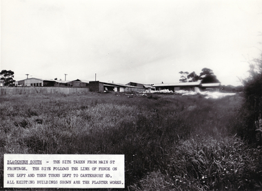 Whitehorse Historical Society Inc.
Photograph - B/W Photograph, Site of Blackburn Fibrous Plaster Works, 9/11/1962 12:00:00 AM
Black and white photo of Site of Blackburn Fibrous Plaster Works in Main Street, Blackburn South.blackburn fibrous plaster works, nth blackburn