Showing 10897 items
matching land
-
 Ringwood and District Historical Society
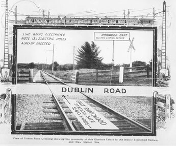
Photograph, Dublin Road Ringwood East Railway Crossing, looking west, 1923. Image from land sale brochure
Black and white photographFront of photo shows sketches of a train and carriages, electric poles and posts and arrows illustrating the direction of the view (the direction described is opposite to what is shown) -
 Ringwood and District Historical Society
Document - Research Notes, Richard Carter, Land Subdivisions in Ringwood 1890-1950
Handwritten table listing main local pre-1950s subdivisions in the Ringwood area, with estate names, streets, number of allotments for sale, and where known, vendor agent, LP (Lodged Plan) title registration number, and auction/sale date, some with sale price.Pg1 RINGWOOD STATION ESTATE LP3070 (Year?) Station Street, William Street (now Kendall Street), Wantirna Road, Station Street Pg1 RINGWOOD TOWNSHIP ESTATE LP5577 (1913) Station Road (now Warrandyte Road), Pratt Street (part now Aird Street), Whitehorse Road Pg2 RINGWOOD ORCHARD ESTATE LP4315 (1914) Brysons Road, Hillcrest Road, Anzac Avenue, Sulva Road Pg3 RINGWOOD RAILWAY ESTATE LP7522 (1918) Whitehorse Road (now Mount Dandenong Road), Dublin Road, Freeman Street, Patterson Street, Bona Street Pg4 THE RINGWOOD ESTATE LP7578 (1919) Warrandyte Road, Hobart Street, Paxton Street, Arnold Street Pg5 GARDEN FARMS ESTATE (LP?) (1919) Canterbury Road, Armstrong Road, Bungalook Road, Orchard Road, Bayswater Road (now Mountain Highway) Pg6 THE RINGWOOD ESTATE (SECOND SUB-DIVISION) LP7604 (1919) Warrandyte Road, Tamar Street, Derwent Street, Mersey Street Pg7 RINGWOOD STATION ESTATE LP7703 (1919) Bedford Road, Williams Grove (now Lena Grove) Pg8 RINGWOOD TOWNSHIP ESTATE LP8198 (1919) Wantirna Road, Ellison Street, Haig Street, Greenwood Avenue Pg9 EASTFIELD ESTATE (LP?) (1920) Eastfield Road, Longview Road, Pleasant Rise, The Mount Pg10 ELECTRIC RAILWAY ESTATE RINGWOOD LP9473 (1922) Campbell Street, Myrtle Avenue, George Street (now Tudor Court), Henry Street (now Myrtle Avenue), Williams Grove (now Lena Grove) Pg11 RINGWOOD PARK ESTATE LP7884 (1922 - two stages) Wonga Road (now Loughnan Road), William Street, Andrew Street, Harrison Street Pg12 HEATHMONT STATION ESTATE LP11009 (Date? - after 1922) Lisgoold Street, Viviani Crescent, Balrour Avenue, Station Street (now part Heathmont Road and part Wainui Street) Pg13 RINGWOOD RAILWAY ESTATE LP10507 (1923) Whitehorse Road, Sherbrooke Avenue, Burwood Avenue, Bonview Avenue, Heatherbrae Avenue, Grant Crescent Pg14 GARDEN HOMES ESTATE (LP?) (1923) Mullum Road, The Centreway, Wattle Crescent (now Wattle Avenue) Reserve Crescent (now Reserve Road) Pg15 DUBLIN ROAD ESTATE LP11993 (1923) Alexandra Road, Vonadawn Avenue, Green Street, Wood Street, Howard Avenue, Bedford Road, Dublin Road Pg16 CARLINGA ESTATE RINGWOOD LP9620 (1923) Bourke Street, Bond Street, Ringwood Street Pg17 PRATT'S JUNCTION ESTATE (LP?) (1923) Junction Street, Georges Road, Oliver Street, Whitehorse Road Pg18 EAST RINGWOOD ESTATE LP10492 (1923) Bona Street, Patterson Street, Miller Grove, Fairview Avenue, Eastfield Road, Whitehorse Road (now Mount Dandenong Road) Pg19 COLEMAN'S HEATHMONT ESTATE LP9974 (1923) Canterbury Road, Bedford Road, Alvena Crescent, Coleman Street, Leonard Street (now Royal Avenue) Pg20 RINGWOOD HEIGHTS ESTATE LP10506 (1924) Whitehorse Road, Bonview Avenue, Grant Crescent, Hillcrest Avenue, Heatherbrae Avenue, Margaret Street, Mary Street Pg21 EAST RINGWOOD STATION ESTATE LP10551 (1924) Knaith Road, Wenwood Street, Lois Street, Victoria Street, Station Street (now Railway Avenue) Pg22 GRAND VIEW ESTATE LP11019 (1924) Whitehorse Road, Rupert Street, Herbert Street, Leonard Street Pg23 RINGWOOD RAILWAY ESTATE & RINGWOOD HEIGHTS ESTATE - FINAL SECTIONS LP10506 & LP10507 (1924) Whitehorse Road, Sherbrooke Avenue, Burwood Avenue, Bonview Avenue, Heatherbrae Avenue, Margaret Street, Mary Street, Grant Crescent Pg24 RINGWOOD EAST ELECTRIC STATION ESTATE (LP?) (1924) Railway Parade (now Patterrson Street), Federal Road, Howship Avenue (part now French Street), Dublin Road, Rosedale Crescent Pg25 BEDFORD PARK (now Ringwood Secondary College) (LP?) (1924) Bedford Road, Adams Street, Anderson Street, Joyce Street, Graham Road Pg26 CROWN JEWEL ESTATE LP11645 (Private sales after 1924) Mount Dandenong Road, Mirabel Avenue, Valda Avenue, Evon Avenue, Velma Grove Pg27 GRAND CENTRAL ESTATE LP10917 (1925) Heathmont Road, Great Ryrie Street, Douglas Street, Garden Street, Bellevue Avenue Pg28 RINGWOOD (unnamed estate - 1926) Nelson Street, Seymour Street, Whitehorse Road Pg29 EAST RINGWOOD RAILWAY STATION ESTATE (YEAR? - 25 shops 60 villas) Railway Avenue, Dublin Road, Lawrence Grove, Stanley Avenue, Knaith Road Pg30 CHARM VIEW ESTATE (LP?) (year? - after 1926) Canterbury Road, Heathmont Road, Dickasons Road, Bennjett Avenue, Orchid Street Pg31 SUNBEAM ESTATE LP12150 (Circa 1925) Govt Road (now Old Lilydale Road), Sunbeam Avenue, Holland Road, Everard Street (now Everard Road) Pg32 FAIRVIEW ESTATE EAST RINGWOOD LP10853 (Circa 1924) Eastfield Road, Patterson Street, Margaret Street (now Short Street) Pg33 EAST RINGWOOD TOWNSHIP ESTATE LP3025 (Circa 1924 - 35 allotments) Mount Dandenong Road, Grey Street, Eastfield Road Pg34 EAST RINGWOOD TOWNSHIP ESTATE LP3025 (Circa 1924 - 49 allotments) and STATE SCHOOL ESTATE (26 allotments) and EAST RINGWOOD STATION ESTATE (14 shop sites) Mount Dandenong Road, Grety Street, Dunn Street, Eastfield Road, King Street, Holland Road, Dublin Road, Patterson Street, Bona Street Pg35 EAST RINGWOOD CENTRAL ESTATE LP17004 (1948) Knaith Road, Shasta Avenue, Talofa Avenue, Russet Road, Dublin Road Pg36 WARE ESTATE LP43360 (1958) Ware Crescent, Davey Drive, Grey Road (now Grey Street), Mount Dandenong Road Pg37 Lot 57 Kendall Street LP3070 (1939) £75.0.0 Pg37 Lot 14 LP7346 (year?) £225 Pg37 Lot 8 WHITE HORSE ESTATE LP14010 (year?) Maroondah Hwy, Seymour Street £98.9.0 Pg37 Lots 4-14 incl. LP10902 (year?) £300 Pg37 Lots 69&70 LP2216 (1939) Bedford Road, Pitt Street £500 Pg37 Lots 60&70 LP2216 (year?) £460 Pg37 MOUNTAIN VIEW ESTATE LP10902 (1936) Lots 1&2, 19-22 Wantirna Road, Daisy Street £50 Pg38 RAILWAY STATION ESTATE RINGWOOD EAST LP7522 (1925) Lots 16 to 19 £250 Pg38 RINGWOOD PARK ESTATE (LP?) (1924) Lot 112 Munro Street £230 Pg38 RINGWOOD TOWNSHIP ESTATE (LP?) (1925) Lot 57 Wantirna Road £850 Pg38 ELECTRIC RAILWAY ESTATE LP9473 (1925) Lot 98 & 99 £180 (30/- foot) Pg38 ELECTRIC RAILWAY ESTATE LP9473 (year?) Lot 100 £233.12.6 incl improvements (£2.12.6 foot) Pg38 Lot 22&23 Bedford Road Heathmont (LP & year?) £675 incl improvements Pg39 Lot 9 Mullum Mullum Road LP8221 (1923) £150 Pg39 Lot 27 Haig Street LP8198 (1925) £825 Pg39 Lot 56 Haig Street cnr Wantirna Road LP8198 (1923) £171 Pg39 Lots 3 & 4 Loughnan Road LP9626 (192?) £147 Pg39 Lots 98 & 99 Myrtle Avenue LP9473 (1925) £180 Pg39 Lots 80 & 81 Myrtle Avenue LP9473 (1929) £150 Pg39 Lot 30 Sherbrooke Avenue LP10507 (1926) £700 incl improvements Pg40 Lot 10 (year?) LP7703 £750 Pg40 Lot 36 (year?) LP7522 £25 Pg40 Lot 38 Pitt Street LP2216 (year?) £350 Pg40 Lot 7 Dublin Road cnr Green Street LP11993 (year?) £300 -
 Victorian Railway History Library
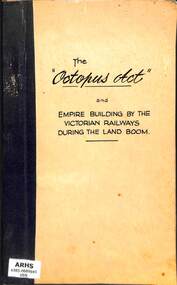
Book, Michael Anthony Venn, The Octopus Act and empire building by the Victorian Railways during the land boom, 1973
A thesis for the Master of Arts Preliminary Course of the History school at Melbourne University, on the empire building by the Victorian Railways with the Railway Construction act of 1884... known as the Octopus Act.bib, maps, p.80.non-fictionA thesis for the Master of Arts Preliminary Course of the History school at Melbourne University, on the empire building by the Victorian Railways with the Railway Construction act of 1884... known as the Octopus Act.victorian railways construction - history, railway expansion - victoria - history -
 Darebin Art Collection
Painting, Katherine Taylor, Land Sights, 2004
-
 Darebin Art Collection
Photograph, Peta Clancy, Shadowy Land 8 & 9, 2014
butterflies -
 Narre Warren and District Family History Group
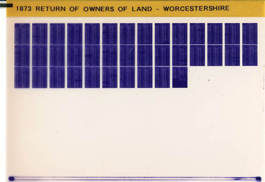
Film, West Surrey Family History Society, Return of Owners of Land Worcestershire, England 1873, 1990s
The Return of Owners of Land, 1873 for Worcestershire provides a fascinating glimpse into land ownership during the Victorian era. It lists landowners with holdings of one acre or more, detailing the size and estimated rental value of their properties. This survey was part of a broader effort to address concerns about land monopolies and to provide transparency about land distribution. For Worcestershire, the records highlight the disparities in land ownership, with a small number of individuals owning vast estates while many others held smaller plots. The survey also includes information about common lands and waste lands in the county.Set of 1 microfiche non-fictionThe Return of Owners of Land, 1873 for Worcestershire provides a fascinating glimpse into land ownership during the Victorian era. It lists landowners with holdings of one acre or more, detailing the size and estimated rental value of their properties. This survey was part of a broader effort to address concerns about land monopolies and to provide transparency about land distribution. For Worcestershire, the records highlight the disparities in land ownership, with a small number of individuals owning vast estates while many others held smaller plots. The survey also includes information about common lands and waste lands in the county. england -- worcestershire, worcestershire, worcestershire -- land owners -
 Narre Warren and District Family History Group
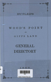
Book, Henry Young et al, Butler's Wood's Point and Gipps Land general directory 1866, 1985
This directory records a lot of different towns with the residents listed with their occupations Included as well is a lot of advertisements from these days97 p.; 22 cmnon-fictionThis directory records a lot of different towns with the residents listed with their occupations Included as well is a lot of advertisements from these daysbank of vic, cleland depot, gippsland land steam navigation co., mcdonald photographic studio, woods boarding house -
 Ringwood and District Historical Society
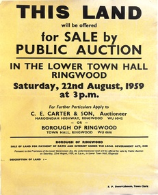
Poster, Land for Sale by Public Auction, Lower Town Hall, Ringwood - Saturday 22nd August, 1959
Yellow poster and smaller attachment with auction details and summary of four properties offered under Borough of Ringwood instructions for unpaid rates, some with handwritten monetary notations.Lot 49 Patterson Street, East Ringwood (Opp. station). Made Road, Water and E.L. 60'x220' approx. Lot 48 Stoda Street, Heathmont. Water and E.L. 50'x150'. Lot 86 Cnr Heatherbrae & Burwood Avenues, Ringwood. Made roads, Water and E.L. 54'x140' approx. Lot 13 Tagell Road Ringwood. 64'x1130' approx. For further particulars apply to C.E. Carter & Son, Auctioneer, Maroondah Highway, Ringwood (Phone) WU6042, WU6830, or Borough of Ringwood, Town Hall, Ringwood (Phone) WU6616. F.P. Dwerryhouse, Town Clerk. -
 Ringwood and District Historical Society
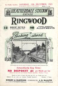
Flyer, Subdivisional Land Auction Sale Brochures, Heatherdale Station Estate, Ringwood, Vic. - 1923 and 1924
Two double sided multi-folded pages advertising public auction sales of shop sites and residential allotments on Saturday, 15th December, 1923 and Saturday, 2nd February, 1924, including summary of local facilities, services and map showing layout of the estate. Includes a photograph depicting proposed site for first Heatherdale railway station and a panoramic view of Ringwood from the railway level crossing in Heatherdale Road. 1923 and 1924 flyers are identical except for the auction dates printed at the top.Subdivision includes Heatherdale Road, Molan Street, Yallourn Parade, Newman Street, and Madden Street. Agents - Knight & Harwood, 315 Collins Street, Melbourne, Phone 10615, 10616 Central, in conjunction with J.B. McAlpin, Opposite Railway Station, Ringwood. Phone Ringwood 7. Additional cardboard-backed copy of map includes later penciled sales notations for some blocks (VC 5801 refers). -
 Narre Warren and District Family History Group
Book, Shirley Swayn, A new land and a new beginning : a pictorial and written history and tree of James and Mary Swayn and their descendants, 1982
...non-fiction... -
 Narre Warren and District Family History Group
Book, WG Manifold, The wished-for-land : the migration and settlement of the Manifolds of western Victoria, 1984
...non-fiction... -
 Narre Warren and District Family History Group
Book, Frances Cotton, Kettle on the hob : A Family in Van Diemen's Land 1828-1885, 1991
...non-fiction... -
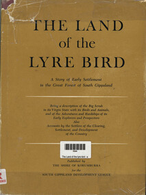 Narre Warren and District Family History Group
Book, The Land of the lyre bird : a story of early settlement in the great forest of South Gippsland, 1966
A story of early settlement in the great forest of south Gippsland. Being a description of the Big Scrub in its virgin state with its birds and animals, and of the adventures and hardship of its early explorers and prospectors; also accounts by the settlers of the clearing, settlement, and development of the countrynon-fictionA story of early settlement in the great forest of south Gippsland. Being a description of the Big Scrub in its virgin state with its birds and animals, and of the adventures and hardship of its early explorers and prospectors; also accounts by the settlers of the clearing, settlement, and development of the countrysouth gippsland, korumburra (vic.), land settlement, victoria, gippsland, personal observations, history -
 National Vietnam Veterans Museum (NVVM)
Manual, Australian Army, Australian Army: Manual Of Land Warfare, Part Three: Training. Volume Phamphlet No 6 Instructors Handbook, 1984
A khaki coloured cardboard cover with black information on the front. Top right hand corner reads 7610-66-120-5877. Under the Australian Army insignia are the details of the manual. There are two punch holes down the left hand side of the manual.australia - armed forces - service manuals, land warfare, training, instructor's handbook -
 Lakes Entrance Historical Society
Book, Spurway John T & Allen Allison, General Musters of New South Wales Norfolk Island and Van Diemens Land, 1992
This volume contains biographical and genealogical information about Australians, famous and infamous, and ordinary citizens compiled from information provided by family historians.genealogy, biography -
 Darebin Art Collection
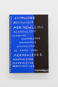
Painting, Mia Boe, 'Thank you for your acknowledgement, can we have our land back now', 2025
“Although acknowledgements of country are very necessary, there is something so painful about hearing people in power acknowledge Aboriginal country whilst at the same time doing nothing to support Aboriginal people or land in meaningful ways. The amount of CEOS, politicians, and people in power who acknowledge country whilst actively benefitting from Aboriginal Land is sickening. Words can only do so much. What we really want is our land back.” – Mia Boe Artist Bio Mia Boe is a painter from Brisbane with Butchulla and Burmese ancestry. The inheritance and disinheritance of both cultures is the focus of her practice. Boe’s paintings respond, sometimes obliquely, to historical and contemporary acts of violence perpetrated on the people and lands of Burma and Australia. Boe received a Bachelor of Art, majoring in Art History from the University of Queensland in 2020. In 2021, she was a recipient of the Brett Whiteley Travelling Scholarship from the Art Gallery of New South Wales and in 2024 she was the Fiona Foley Residency recipient, where she undertook a residency on K’gari and Hervey Bay in Queensland. She was a Gertrude Contemporary Studio Artist between 2022 and 2024, and has undertaken further residencies in Mexico City and Sydney. -
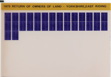 Narre Warren and District Family History Group
Film, Tim Wilcock et al, Return of Owners of Land Yorkshire (East Riding), England 1873, 1992-1995
"This return is intended to show with regard to England and Wales (exclusive of the Metropolis) - 1. The number and names of owners of land of one acre and upwards, whether built upon or not, in each County, with the estimated acreage and annual gross estimated rental of the property belonging to each owner 2. The number of owners of land, whether built upon or not, of less than one acre, with the estimated aggregate gross estimated rental of the lands of such owners 3. The estimated extent of commons and waste lands in each County."--Explanatory statement.Set of 1 microfiche non-fiction"This return is intended to show with regard to England and Wales (exclusive of the Metropolis) - 1. The number and names of owners of land of one acre and upwards, whether built upon or not, in each County, with the estimated acreage and annual gross estimated rental of the property belonging to each owner 2. The number of owners of land, whether built upon or not, of less than one acre, with the estimated aggregate gross estimated rental of the lands of such owners 3. The estimated extent of commons and waste lands in each County."--Explanatory statement. yorkshire -- east riding, yorkshire -- east riding -- land tenure, yorkshire -- east riding -- genealogy -
 Ringwood and District Historical Society
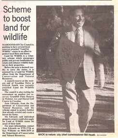
Newspaper, Scrapbook Clipping, Library Collection, Ringwood, Victoria, `
``Newspaper clipping from "The Mail", 4-7-95, P 6. NEWS WATCH- Scheme to boost land for wildlife Maroondah City Council is pushing to have several local reserves awarded "Land for Wildlife" status in an effort to protect local flora and fauna. A council reserve at the western end of Tereddan Drive in Kilsyth South was recently awarded Land for Wildlife Status` -
 Warrnambool and District Historical Society Inc.
Original Document, Map: Agricultural area of Ballangeich 1865, 1865
George Eddington arrived in Australia in 1839 and named and established property in 1841 calling the property Ballangeich after a Pass near his home town of Stirling in Scotland. It is situated 151 miles west of Melbourne and to the south of Mortlake and was originally part of the Mortlake shire, which was proclaimed 26th Jan 1864. Nearest streams are the Hopkins Riverand Lyall and Drysdale creek running through good agricultural land. This map relates to the breaking up of large runs which the Victorian government enabled through selection acts of the 1860's. The previously larger runs which were mainly cattle and sheep based were now more open to closer settlement and a greater variety in farming.The lots range in size from approximately 50 acres to around 600 acres.Some areas are set aside for reserves. By 1886 the population of Ballangeich had grown to around 600 with an hotel, three state schools and a church.Tri weekly coaches ran to Colac, Warrnambool and Camperdown providing access to supplies mail and communication. This map is typical of many which were produced in the 1860's in Victoria during a significant period of Victoria's and Warrnambool district history.Rectangular light card paper with black text showing allotments of land The area is coloured in green with scale at bottom right cornerAt the top: Plan of the Agricultural area of Ballangeich 1865 At the bottom left: Prepared by the Board of Lands & Works in accordance with the Amending Land Act 1865 Lands & Survey Office Melbourne 13th April 1865. With signaturehistory of warrnambool, ballangeich, land surveys victoria 1865, lands act 1865 victoria, ballangeich map 1865 -
 Bendigo Military Museum
Photograph - Army Survey Regiment Personnel – Mahogany Ship Survey, Warrnambool, VIC, 1985
This is a photograph of Army Survey Regiment personnel undertaking surveying measurements during a search for the ‘Mahogany Ship’ Warrnambool, VIC on 3rd September1985. CPL Mark Lander and SGT Don Williams were taking electronic distance measurements using an MRA-301 tellurometer. To measure the distance, personnel at another site operating another MRA-301 tellurometer would have exchanged the signal emission. A ‘Hilga Watts’ light appears in the background and a barometer in the foreground.This is a photograph of Army Survey Regiment personnel undertaking surveying measurements during a search for the ‘Mahogany Ship’ Warrnambool, VIC on 3rd September1985. The photograph was printed on photographic paper and is part of the Army Survey Regiment’s Collection. The photograph was scanned at 300 dpi. L to R: CPL Mark Lander, SGT Don Williams‘R.S. 3/9/1985 CPL Mark Lander, SGT Don Williams PIC BY COURTESY OF THE WARRNAMBOOL STANDARD’ annotated on back of photoroyal australian survey corps, rasvy, army survey regiment, army svy regt, fortuna, asr, surveying -
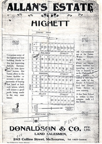 City of Moorabbin Historical Society (Operating the Box Cottage Museum)
Flyer - Allan's Estate, Highett, 1922
The train line from the city to Frankston was electrified in 1922 which intensified the sale in the municipality of Moorabbin, particularly land which was in the vicinity of the railway stations.Example of the progress of the Municipality of MoorabbinPhoto copy of advertising flyer for auction of real estate sales - plan of building blocks for saleAllan's Estate, Highett land saleshighett road, baldwin street, harding street, allen street, highett, real estate, auctions -
 Bacchus Marsh & District Historical Society
Map, Lerderderg Park Lands sale plan. 1911
This plan was for the sale of parcels of land from the Lerderderg Park Estate property in 1911. Advertising for the sale appeared in the Bacchus Marsh Express newspaper through July of 1911. The property was situated only a few kilometers from the township of Bacchus Marsh. The agents for the sale were L. A. Fairbairn & Co.Lerderderg Park Estate was a significant and early colonial property in the Bacchus Marsh area. This plan provides details about the first time the property was subdivided for sale. It is therefore documents an important moment in the history of this property and the broader trend of the subdivision of older and larger properties in the district.A single page paper plan showing allotments of land for sale from the Lerderderg Park property owned by John Wills. The parcels of land for sale are coloured in red.The Lerderderg River and Pyke's Creek Irigation Channel shown on the plan are in blue ink. The rest of the plan is a dark cream or beige colur with the text in black ink. The plan has been extensively annotated with hand-written notes indicating the names of people who purchased the various parcels of lands and the prices paid for those lands. Part of the top of the plan containing some text appears to be missing. The plan is pasted into a bound volume containing 76 maps or plans in total. Top: Have received instructions to Sell, account Mr John Wills, his renowned LERDERDERG PARK LANDS, so well and favourably known throughout the Commonwealth. In areas from 3 acres to 1276 acres. Every lot is either rich lucerne land (or portion now under lucerne) with some higher land adjoining Railway Station, and 2 Milk factories within 2 miles, absolutely the finest land in Victoria. Bottom: THIS IS THE FIRST SUBDIVISIONAL SALE of Rich Flats in Bacchus Marsh since the Pyke's Creek Scheme, and every lot is commanded by it. Only 32 miles from Melbourne.bacchus marsh victoria maps, land sales, lerderderg park estate, land subdivision -
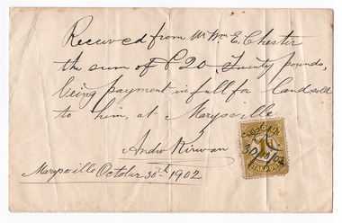 Marysville & District Historical Society
Ephemera (Item) - Land sale certificate, Mr Andrew Kirwan, 30-10-1902
A land sale certificate between Mr and Mrs E. Chester and Mr Andrew Kirwan dated October 30th, 1902. The land sold was in Marysville.A land sale certificate between Mr and Mrs E. Chester and Mr Andrew Kirwan dated October 30th, 1902. The land sold was in Marysville.marysville, victoria, australia, land sale certificate, mr and mrs e. chester, mr andrew kirwan -
4th/19th Prince of Wales's Light Horse Regiment Unit History Room
Royal Appointment, S G A Hindhaugh, 9 Oct 1916 (Original)
A copy of the appointment of Stanley George Allen Hindhaugh to Captain in His Majesty's Land Forces on 5th August 1914. It is dated 9th October 1916. On back: S G A Hindhaugh Captain Land Forces 4th Australian Light Horse (Victoria) 66/3180appointment, hindhaugh -
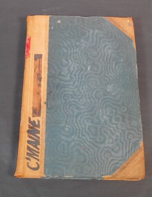 Bendigo Historical Society Inc.
Administrative record - Reports of sales by auction
Blue book with brown corners and spine, red label on spine with the title in gold letters "Reports of sales by auction". Letter "C" on spine. C'Maine on front cover. The book contains official Crown land sales documents, the papers are glued into the book. The book contains the purchasers' names, land section, allotments and price. Cover the period from 1893 to 1905.11/1/1893 to 12/03/06 written on the spine. Land sale reports 1880 written on inside cover. land sales, crown land, auctions -
Whitehorse Historical Society Inc.
Letter - Correspondence, John McClelland, 1905
Letter to John McClelland from solicitors in 1905 regarding the transfer of land to members of his family.Letter to John McClelland from solicitors in 1905 regarding the transfer of land to members of his family. Land was north and south of the railway in Tunstall (sketch).Letter to John McClelland from solicitors in 1905 regarding the transfer of land to members of his family. mcclelland, john, mcclelland family, tunstall -
Whitehorse Historical Society Inc.
Book, Aboriginal Melbourne, 1998
Subtitled 'the lost land of the Kulin people.Subtitled 'the lost land of the Kulin people. Previously published as 'The Land of the Kulin', 1985. Author's presentation copy to Ted and Valda Arrowsmith.Subtitled 'the lost land of the Kulin people. aborigines, kulin -
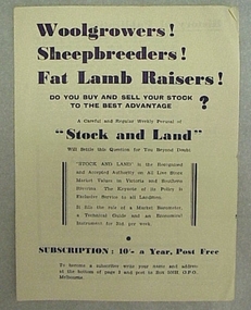 National Wool Museum
Leaflet
Subscription leaflet and application for "Stock and Land" newspaper.Subscription leaflet and application for "Stock and Land" newspaper.Geelong 848594 6/- 20/11 Prahran B893271 6/- 13/2/46agriculture - news, stock and land, woods, mr george -
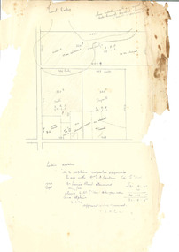 Beechworth Honey Archive
Hand-Drawn Diagram of Land by Frank Lebbell Frost September 1920
Hand-drawn diagram of land at Dookie by Frank L. Frost. Depicts plan od three allotments.hand drawn, hand-drawn, plan, land, dookie, frost, beekeeper, beechworth honey -
Tatura Irrigation & Wartime Camps Museum
Poster, Subdivision of Township Allotments
Poster depicting the land which was being sold by J S Darby on the 3 December 1890. Auctioneer was Martin Cussen and Co. Map shows location of land.Single sheet of paper, laminated. Advertising land subdivision for sale in the township of Rushworth. Being sold by Martin Cussen and Co, auctioneers for J S Darby. Shows map of land subdivision.rushworth, land subdivision, martin cussen and co, j s darby