Showing 3624 items
matching mining - gold
-
 Marysville & District Historical Society
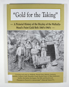
Book - Hardcover book, Gold for the Taking-A Pictorial History of the Heyday of the Walhalla-Wood's Point Gold Belt: 1860's-1960's, 2007
... gold mining... on tracks which lead into the mine.There is also an old gold mining...'s gold gold fields gold mining a1 mine settlement aberfeldy ...A pictorial history of the heyday of the Walhalla-Wood's Point gold belt in the 1860's-1960'sHardcover. The cover is a gold colour. The front cover has a photograph of a group of miners in front of the entry to a mine. On the top entry timber piece is a sign saying "Old Mine". The beginning of the wording is obscured by one of the miners standing in front of the entry. There is also an old mining trolley standing on tracks which lead into the mine.There is also an old gold mining dish sitting on a rock to the left of the entry into the mine.On the back cover is a photograph of Walhalla in modern times as well as a photograph of the publisher of this book. There is also a blurb about the publisher.Stamp of the Marysville & District Historical Society Inc / P.O. Box 22 / Marysville 3779gold, gold fields, gold mining, a1 mine settlement, aberfeldy, beardmore, black river group, coopers creek, donnellys creek, enochs point, fulton creek, gaffneys creek, gooleys creek, jamieson, jordan valley, kevington, knockwood, matlock, ten mile, walhalla, wood's point, history, victoria -
 Bendigo Historical Society Inc.
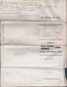
Document - MCCOLL, RANKIN AND STANISTREET COLLECTION: CENTRAL NELL GWYNNE, 16/1/1939
... gold mining...Document. South Nell Gwynne Gold Mining Company... Central Nell Gwynne gold mining lease South Nell Gwynne notice ...Document. South Nell Gwynne Gold Mining Company No Liability of Charing Cross, Bendigo. Dated 5th October 1938 now the prop. Of the within described estate by transfer registed on 16th Jan 1939 & numbered 1718022 Assistant Registrar of titles His Majesty the King to Central Nell Gwynne GMC N/L. Superseded by new lease. - Also included 1 copy of notice of application for a tailings licence + 2 attached pages including a rough plan of site. No 10983 Bendigo Vol 322 Fol 35596.McColl, Rankin & Stanistreetorganization, business, central nell gwynne, mccoll, rankin & stanistreet, central nell gwynne, gold mining, lease, south nell gwynne, notice of application for tailings lilcence -
 Bendigo Historical Society Inc.
Document - ALBERT RICHARDSON COLLECTION: GARDEN GULLY UNITED MINE
... gold mining... of the Garden Gully United Gold Mining Company. Albert Richardson writes... gold mining poppet legs Rosalind Park Three page typed document ...Three page typed document plus map showing location of the Garden Gully United Mine. The history and features of the mine operation are described and include: the locality of the shafts, winding engine, air compressor, crushing battery, engine house, gold obtained and dividends and gold production. The lookout tower in Rosalind Park was formerly the poppet legs of the Garden Gully United Gold Mining Company. Albert Richardson writes: ' a fitting tribute to Bendigo's most famous goldmine. The four legged lookout tower, was originally the six legged poppet legs of the Garden Gully United.bendigo, mining, garden gully united mine., garden gully united mine, gold mining, poppet legs, rosalind park -
 Bendigo Historical Society Inc.
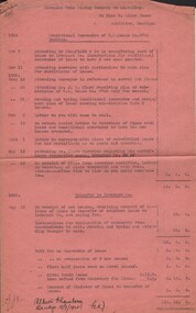
Document - MISS G ALICE JONES COLLECTION: ACCOUNT
... New Balaclava Gold Mining Syndicate Ltd...New Balaclava Gold Mining Syndicate Ltd. To Miss G. Alice... Mining Syndicate Ltd Mr Leed Mr Field New Balaclava Gold Mining ...New Balaclava Gold Mining Syndicate Ltd. To Miss G. Alice Jones. Pink paper dated May 16, 17, June 1, 2, July 27, Aug 8, 11, 14, 28, 29, Sep 4 to Oct 5 and 10/11/1933. Re Reconstruction of Co., Alterations of Rules, new Manager & office, Sale of assets to trustee for new Company, and Agreement with Trustee for new Company. Total cost £10.10.0. "R?81 Del 10/11/33" written in the top left corner.the miss g alice jones collection - account, new balaclava gold mining syndicate ltd, mr leed, mr field -
 Bendigo Historical Society Inc.
Document - MISS G ALICE JONES COLLECTION: ACCOUNT
... Hercules Gold Mining co N L...Hercules Gold Mining Company No Liability to Miss G. Alice... Mining co N L Mr Stanfield Ironbark Co Mr J R Clark Hercules Gold ...Hercules Gold Mining Company No Liability to Miss G. Alice Jones. Conditional Surrender of G.M. Lease No.9766 Bendigo. Pink paper dated Nov 7, 11 1924, Jany 12, 28, 31, Feb 2, 16, April 1, May 12, 23 and Aug 15, 1925. Details for Conditional Surrender of G.M. Lease No.8766. Cost £2.2.0. and transfer to Ironbark Co. including fees, rent and transfer of lease. "R396 Posted 23/8/25" written in top left corner. Total cost£10.19.3.miss g. alice jones collection - account, hercules gold mining co n l, mr stanfield, ironbark co, mr j r clark -
 Bendigo Historical Society Inc.
Document - MISS G ALICE JONES COLLECTION: ACCOUNT
... Carlisle Gold Mining Company No Liability...Carlisle Gold Mining Company No Liability to Miss G. Alice.... Carlisle Gold Mining Company No Liability to Miss G. Alice Jones ...Carlisle Gold Mining Company No Liability to Miss G. Alice Jones. Pink paper dated Feby. 29, March 5, 11, 13, Nov. 7, 14, 25, Dec. 3, 5, 10, 11, 19 1924, Jany 30, 31, Feby 2, 19, 1925. Account details work and costs re: Kirby, B.A.G. Ltd. To you. Transfer of G. M. Lease, B.A.G. Ltd. To you Machinery Lease. Total Cost 10.10.0. "Posted 7/7/25" written in top left corner.miss g. alice jones collection - account, carlisle gold mining company no liability, kirby, mr stanfield, b.a.g. ltd. -
Bendigo Historical Society Inc.
Plan - MARKS COLLECTION: LEASE PLANS GREAT SOUTHERN GOLD MINE BENDIGO
... Southern Gold Mining Co. Bendigo' \Total area123 acres, 3 roods... BENDIGO Mining great southern gold mine Plan on heavy paper ...Plan on heavy paper, tightly rolled. On top of plan Plan of Leases 5429, 4810, 4811 and 5429, The Property of the Great Southern Gold Mining Co. Bendigo' \Total area123 acres, 3 roods, 33 perches, excised, nett area 122, 0. 38. On bottom '32 feet to one inch' and 'This plan was devised from Government Mining Lease Plans and from actual survey' Signed E.F Brown, certificated mining and authorised surveyor 25/6/87' Leases No. 5429 and 4810 details location of shaft, tramway, battery, engine house and boiler. Large mining dam outlined.bendigo, mining, great southern gold mine -
 Bendigo Historical Society Inc.
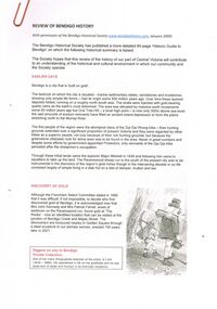
Document - ''REVIEW OF BENDIGO HISTORY'' (BHS)
... Alluvial Gold Mining. S. T. Gill... Days; Discovery of Gold; Influx of Diggers; Water and Mining... Architectural Influx of diggers Alluvial Gold Mining. S. T. Gill Bendigo ...''Review of Bendigo History'' 8 pages, with three appendices. (Published by the BHS and based on the more detailed 60-page 'Historic Guide to Bendigo'). Sections headed: Earlier Days; Discovery of Gold; Influx of Diggers; Water and Mining; Transport and Development; Building and the City; A Place of Commerce; Heritage of the Past; Further information - references; Appendix 1 - Alluvial Gold Mining in Bendigo; appendix 2 - Architectural and Heritage Features; Appendix 3 - Historical Time Line Summary (1836 - 2003). Limited number of illustrations. Attached is correspondence with Data Metallogenica re the use of this Review (date 2009). Also included are 3 pages of and email, and 2 pages of advertising Data Metallogenical.Bendigo Historical Societybendigo, history, bendigo historical society, water, mining, architectural, influx of diggers, alluvial gold mining. s. t. gill -
Tarnagulla History Archive
Box of Murray Comrie's Research Notes (Set 1), Murray Comrie's Research Notes (Set 1), circa 1960s-80s
... gold & mining... with the following subject matter: Banks Lodge Gold & mining War/Military.... tarnagulla comrie research banks lodge gold & mining war/military ...Murray Comrie Collection. Murray Comrie, born in Tarnagulla in 1912 also became a policeman and later a Chief Superintendent, retiring in 1972 and passing away in 1983 after a long illness. Murray Comrie's son Murray Jnr., to avoid confusion became known by his middle name, Neil. Neil Comrie also joined Victoria Police and rose through the ranks to become Chief Commissioner of Victoria Police from 1993 to 2001. Blue-grey archive box containing research notes of Murray Comrie. Within this set are multiple archival folders with the following subject matter: Banks Lodge Gold & mining War/Military Local people Buildings Businesses Local government Post Offices Policing Recreation Reserve Railway Clubs & Societies Band/Music Hotels Churches Schools Fire Brigade Laanecoorie Early white history General (including many captions that accompanied photographs - which were separated from the photos for preservation storage reasons). The contents of these files were research notes compiled by Murray Comrie during his research for a book about Tarnagulla. tarnagulla, comrie, research, banks, lodge, gold & mining, war/military, local people, buildings, businesses, local government, post offices, policing, recreation reserve, railway, clubs & societies, band/music, hotels, churches, schools, fire brigade, laanecoorie, names -
 Bendigo Historical Society Inc.
Document - MISS G ALICE JONES COLLECTION: ACCOUNT
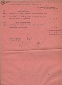
... Central Red White & Blue Gold Mining Co N L.../6/26. Central Red White & Blue gold Mining Co. N.L. to Miss... White & Blue Gold Mining Co N L Mr Jewell Mine Drainage Board Mr ...Pink paper dated Mar 30, Apr 1, 1925, May 14, 1926, and 30/6/26. Central Red White & Blue gold Mining Co. N.L. to Miss G. Alice Jones. Land Tax Return. Mar 30 Attending Mr. Jewell drafting return for 1924-25. Apr 1 Attending Mr. Jewell perusing return as typed and drawing letter to accompany. May 14, 1926, mine Drainage Board. Attending Mr. Stanistreet who stated position and suggesting negotiations. Cost £1 1 0. Pd written on the end. R414 delivered by V B? 1/7/26.the miss g.alice jones collection - account, central red white & blue gold mining co n l, mr jewell, mine drainage board, mr stanistreet -
 Clunes Museum
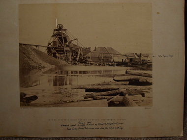
Photograph, APPROX. 1865
... .1 SEPIA PHOTOGRAPH OF CLUNES ALLUVIAL GOLD MINING CO....1 PRINTED: CLUNES ALLUVIAL GOLD MINING COMPANY REGISTERED... PRINTED: CLUNES ALLUVIAL GOLD MINING COMPANY REGISTERED CLUNES .2 ...THIS MINE WAS SITUATED ABOUT 100 YARDS SOUTH WEST OF ALBERT STREET AND ANGUS STREET CORNER. RED CLAY FROM THIS MINE WAS USED FOR BRICK MAKING..1 SEPIA PHOTOGRAPH OF CLUNES ALLUVIAL GOLD MINING CO. .2 SEPIA PHOTOGRAPH OF POPPET HEAD-MINERS ON PLATFORM-THATCHED ROOF BUILDINGS, SCATTERING OF LARGE LOGS IN FOREGROUND, USED FOR FIRES. .3 COPY OF ABOVE PHOTOGRAPH IN BLACK AND WHITE (POSTCARD SIZE).1 PRINTED: CLUNES ALLUVIAL GOLD MINING COMPANY REGISTERED CLUNES .2 PRINTED ON FRONT : ALLUVIAL GOLD MINING COMPANY REGISTERED CLUNES HANDWRITTEN: PERIOD 1865. SITUATED ABOUT 100 YDS SW OF ALBERT AND ANGUS STREET CORNER. RED CLAY FROM THIS MINE WAS USED FOR BRICK MAKINGphotographs, mining, clunes alluvial mining company -
 Bendigo Historical Society Inc.
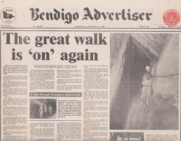
Newspaper - BENDIGO MINING, WALKING UNDERGROUND FROM SPRING GULLY TO EAGLEHAWK
... , 1988, page 1. It was said in the 'heyday of Bendigo's gold... BENDIGO Mining central deborah gold mine Newspaper article ...Newspaper article, Bendigo Advertiser, Thursday October 13, 1988, page 1. It was said in the 'heyday of Bendigo's gold mining it was possible to walk underground from Spring Gully to Eaglehawk' Article describes a walk done in 1988 from the 8th level of the Central Deborah Gold Mine shaft (270 m) through a series of tortuous and at times hazardous drives, stopes, shafts and cross overs to the 8th level of the North Deborah Gold Mine. Steven Hinde, Bendigo Mining's Chief Geologist lead the trek, which proved it was still possible to go down one shaft and emerge up another. When Bendigo Mining dewatered the Central Deborah shaft it uncovered the old connecting passages.bendigo, mining, central deborah gold mine -
 Bendigo Historical Society Inc.
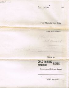
Document - MCCOLL, RANKIN AND STANISTREET COLLECTION: MINING LEASE NO 10173 GARDEN GULLY SHAFT, 9th March, 1934
... Mining lease 5 page document for lease application 10173... Inc. History House 11 Mackenzie Street Bendigo goldfields GOLD ...Mining lease 5 page document for lease application 10173, dated 9th March 1934, within area bounded by Don, Barnard Streets up to Mt. Korong Road, area 10 acres. Document signed by John Jepson Stanistreet in the presence of W.A. Kell, Warden's Clerk, Bendigo. Hand coloured plan of lease appended to document, yellow section refers to lease. Marked on map Central Garden Gully shaft. On front of lease ' entered in the Register Book Vol 303 Fol 33698' On back ' His Majesty the King to J.P. Stanistreet (Cent G Gully not renewed written in pencil) Form C Gold Mining Lease Crown and Private Land'gold, mining, garden gully shaft -
 Bendigo Historical Society Inc.
Document - MCCOLL, RANKIN AND STANISTREET COLLECTION: NEW STAR GOLD MINE HARRIETVILLE NL, SOUTH BLUE CONSOLIDATED SYNDICATE
... Gold mining... for a Gold Mining Lease of land at Bendigo on Southern Extension...Bendigo Gold mining South blue Consolidated McColl Rankin ...McColl Rankin & Stanistreet, New Star Gold Mine Harrietville NL. Collection of documents in envelope. a/ Agreement with the unregistered mining syndicate South Blue Consolidated Syndicate and Gold Exploration (Victoria) Co ML application No. 9982 for a Gold Mining Lease of land at Bendigo on Southern Extension of the Sheepshead or Red White & Blue Line of Reef. Dated: 17/6/1932. Signatures: James Phillips, Stanistreet, J M Leed, C J Michelsen, Jardine?? MacKay. 2 pages. b/ Harry Raymond Johnson & Ellis Douglas McDonnel Doyle on behalf of a No Liability Company to be formed, application for Gold Mining Lease NO. 7514 (Beechworth). Vendors are taking steps to a Company to be entitled New Star Gold Mine Harrietville. Signed: ??, E? McDoyle, ??, McColl Rankin & Stanistreet, ?? Dated:1/5/19/33. 2 pages. c/ Indenture between Ellis Douglas McDonnell Doyle, Harry Raymond Johnson and New Star Gold Mine Harrietville NL the company was formed on 27/6/1933 registered and incorporated. Dated 28/6/1933. Signed: Ke? E D M Doyle, Murphy, Mary R Johnson, J Nicolsen, G? Stanistreet. 2 pages. d/ Memo attached to 2-page letter. Re: adjustment of number of shares for Mr. King. Letter acknowledging receipt of paid shares. Dated 25/7/1933. Signed C B King,?? Page 2 lists brokerage etc. for shares. Dated 11/7/1933. e/ Memo & 3-page letter. Memo re surveyor for Dargo. Allotted shares exceeds available shares. Letter: To Wonnangatta Gold Reefs Syndicate regarding purchase of lease hold property in Mining District of Gippsland. Dated 28/6/1934. Signed ?? Page 2, Balance of monies advanced from R A Rankin. Page 3, costs Re Golden Butterfly Mine. f/ Agreement to lease property in Mining District of Gippsland Mining Lease No's 5187 & 5195 Black Snake Creek Dargo, blue print map of Mine included of No.5187. Dated 28/6/1934. Signed: Keohan?, ??, G ?, Geo Kingsley, Stanistreet. 4 pages. g/ An option to purchase certain Applications for Gold Mining Leases. Date: 28/6/34. Signitures: ? M Neill, ??, G ?, J Nichelsen, Stanistreet. 2 Pages.bendigo, gold mining, south blue consolidated, mccoll rankin & stanistreet -
 Clunes Museum
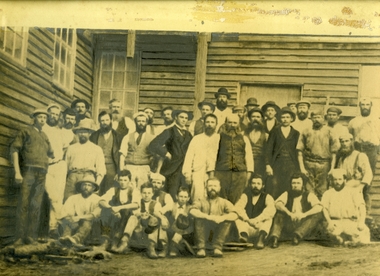
Photograph, SOME OF THE EMPLOYEES OF THE PORT PHILLIP MINING COMPANY
... SOME OF THE EMPLOYEES OF THE PORT PHILLIP GOLD MINING... OF THE PORT PHILLIP GOLD MINING COMPANY BLACK AND WHITE ORIGINAL ...PORT PHILLIP GOLD MINE OF CLUNES EMPLOYED MANY MINERS WHO EVENTUALLY WENT TO WESTERN AUSTRALIA WHEN GOLD WAS DISCOVERED THEREBLACK AND WHITE ORIGINAL PHOTOGRAPH OF EMPLOYEES OF THE PORT PHILLIP MINE .1 FRAMED ORIGINAL PHOTOGRAPH WITH BROWN MATT BOARD. WOODEN FRAME .2 & .3 PHOTO PRINT ORIGINAL, SLIGHTLY BLURREDSOME OF THE EMPLOYEES OF THE PORT PHILLIP GOLD MINING COMPANYlocal history, photography, photographs, mining -
Clunes Museum
Photograph
... SOME OF THE EMPLOYEES OF THE PORT PHILLIP GOLD MINING... OF THE PORT PHILLIP GOLD MINING COMPANY ORIGINAL PHOTOGRAPH ...PORT PHILLIP GOLD MINE OF CLUNES EMPLOYED MANY MINERS WHO EVENTUALLY WENT TO WESTERN AUSTRALIA WHEN GOLD WAS DISCOVERED THEREORIGINAL PHOTOGRAPH OF EMPLOYEES OF THE PORT PHILLIP MINE. IN WOODEN FRAMESOME OF THE EMPLOYEES OF THE PORT PHILLIP GOLD MINING COMPANYlocal history, photograph, photography, mining -
 The Beechworth Burke Museum
Photograph, c1960
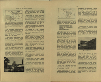
... mountain mining co gold rush redevelopment transformation community ...The photograph depicts a view across the water at Lake Sambell. The image dates from approximately 1960. The present day park and reserve occupies the site of the former Rocky Mountain Mining Company, an open-cut sluice mine that began operations in the mid-Nineteenth Century and operated until the early 1900s, through the peak of Victoria’s Gold Rush. It was converted into a park and leisure area in the 1920s. Lake Sambell was formally opened to the public on Friday 5th October 1928 and was opened by the Victorian Government’s Minister of Lands, Mr Bailey, as part of initiatives to boost the economies and development of country towns. The lake was named after Mr L.H. Sambell, a shire engineer and secretary of the Forward Beechworth Committee who was involved in promoting the transformation of the mining site and promoting plantation forestry and tourism as alternative industries. £300 to begin the process was provided by Mr J. McConvill, a former resident of Beechworth, who is remembered in a street name adjacent to the lake. Residents of Beechworth have worked to raise funds to improve the Lake Sambell reserve several times, such as efforts in the 1930s and 1940s to raise the banks several feet to deepen the water for swimming purposes. Fundraising campaigns include the ‘Ugly Man’ competition conducted on behalf of the Wallace Park-Lake Sambell Development Scheme. The latter competition was run by the Fire Brigade Bend’s team as part of a larger competition called the ‘Mile of Pennies’; it was won by Mr Len Knight of Beechworth’s Commercial Hotel. The ‘Mile of Pennies’ was conducted at a Carnival held on New Year’s Eve, 1947. It was proposed by the Beechworth and District Progress Association. As well as improving swimming facilities, funds were raised to install a caravan park facility near the lake. Funds were also donated by commercial entities, such as £250 received from Zwar Bros. Pty Ltd. The photograph is significant as it shows the level of development of Beechworth in the early to mid-Twentieth Century. Sepia rectangular photograph printed on matte photographic paperObverse: nil. Reverse: 3470 / Velox (paper mark)beechworth, beechworth lake, lake sambell, lake, beechworth and district progress association, forward beechworth committee, ugly man, mile of pennies, wallace park lake sambell development scheme, wallace park-lake sambell development scheme, zwar bros, zwar, l.h. sambell, j. mcconvill, minister of lands, commercial hotel, len knight, rocky mountain mining company, rocky mountain mining co, gold rush, redevelopment, transformation, community fundraising -
 The Beechworth Burke Museum
Photograph, c1960
... mountain mining company rocky mountain mining co gold rush ...The photograph depicts a view across the water at Lake Sambell. The image is thought to date from the 1960s so may show the lake during a period of drought, such as that experienced across South-Eastern Australia in 1967. The present day park and reserve occupies the site of the former Rocky Mountain Mining Company, an open-cut sluice mine that began operations in the mid-Nineteenth Century and operated until the early 1900s, through the peak of Victoria’s Gold Rush. It was converted into a park and leisure area in the 1920s. Lake Sambell was formally opened to the public on Friday 5th October 1928 and was opened by the Victorian Government’s Minister of Lands, Mr Bailey, as part of initiatives to boost the economies and development of country towns. The lake was named after Mr L.H. Sambell, a shire engineer and secretary of the Forward Beechworth Committee who was involved in promoting the transformation of the mining site and promoting plantation forestry and tourism as alternative industries. £300 to begin the process was provided by Mr J. McConvill, a former resident of Beechworth, who is remembered in a street name adjacent to the lake. Residents of Beechworth have worked to raise funds to improve the Lake Sambell reserve several times, such as efforts in the 1930s and 1940s to raise the banks several feet to deepen the water for swimming purposes. Fundraising campaigns include the ‘Ugly Man’ competition conducted on behalf of the Wallace Park-Lake Sambell Development Scheme. The latter competition was run by the Fire Brigade Bend’s team as part of a larger competition called the ‘Mile of Pennies’; it was won by Mr Len Knight of Beechworth’s Commercial Hotel. The ‘Mile of Pennies’ was conducted at a Carnival held on New Year’s Eve, 1947. It was proposed by the Beechworth and District Progress Association. As well as improving swimming facilities, funds were raised to install a caravan park facility near the lake. Funds were also donated by commercial entities, such as £250 received from Zwar Bros. Pty Ltd.The photograph is significant as it shows Lake Sambell at lower water levels, such as may have been experienced during period of drought.Sepia rectangular photograph printed on matte photographic paperObverse: nil Reverse: 3470beechworth, beechworth lake, lake sambell, lake, beechworth and district progress association, forward beechworth committee, ugly man, mile of pennies, wallace park lake sambell development scheme, wallace park-lake sambell development scheme, zwar bros, zwar, l.h. sambell, j. mcconvill, minister of lands, commercial hotel, len knight, rocky mountain mining company, rocky mountain mining co, gold rush, redevelopment, transformation, community fundraising, drought, 1967, 1960s -
 The Beechworth Burke Museum
Photograph, c1960
... mountain mining co gold rush redevelopment transformation community ...The photographs in this set depict views across the water at Lake Sambell. The images date from approximately 1960. The present day park and reserve occupies the site of the former Rocky Mountain Mining Company, an open-cut sluice mine that began operations in the mid-19th Century and operated until the early 1900s, through the peak of Victoria’s Gold Rush. It was converted into a park and leisure area in the 1920s. Lake Sambell was formally opened to the public on Friday 5th October 1928 and was opened by the Victorian Government’s Minister of Lands, Mr Bailey, as part of initiatives to boost the economies and development of country towns. The lake was named after Mr L.H. Sambell, a shire engineer and secretary of the Forward Beechworth Committee who was involved in promoting the transformation of the mining site and promoting plantation forestry and tourism as alternative industries. £300 to begin the process was provided by Mr J. McConvill, a former resident of Beechworth, who is remembered in a street name adjacent to the lake. Residents of Beechworth have worked to raise funds to improve the Lake Sambell reserve several times, such as efforts in the 1930s and 1940s to raise the banks several feet to deepen the water for swimming purposes. Fundraising campaigns include the ‘Ugly Man’ competition conducted on behalf of the Wallace Park-Lake Sambell Development Scheme. The latter competition was run by the Fire Brigade Bend’s team as part of a larger competition called the ‘Mile of Pennies’; it was won by Mr Len Knight of Beechworth’s Commercial Hotel. The ‘Mile of Pennies’ was conducted at a Carnival held on New Year’s Eve, 1947. It was proposed by the Beechworth and District Progress Association. As well as improving swimming facilities, funds were raised to install a caravan park facility near the lake. Funds were also donated by commercial entities, such as £250 received from Zwar Bros. Pty Ltd.The photographs are significant as they show the level of development in Beechworth in the middle of the Twentieth Century. Four sepia and black and white rectangular photographs printed on matte photographic paper. 3469.1: Obverse: nil Reverse: 3469-1 3469.2: Obverse: nil Reverse: 3469-2 3469.3: Obverse: nil Reverse: 3469-3 3469.4: Obverse: nil Reverse: 3469-4beechworth, beechworth lake, lake sambell, lake, beechworth and district progress association, forward beechworth committee, ugly man, mile of pennies, wallace park lake sambell development scheme, wallace park-lake sambell development scheme, zwar bros, zwar, l.h. sambell, j. mcconvill, minister of lands, commercial hotel, len knight, rocky mountain mining company, rocky mountain mining co, gold rush, redevelopment, transformation, community fundraising -
 The Beechworth Burke Museum
Photograph - Photograph - Reproduction, Unknown
... history colonial australia australian gold rushes mining ...This image is a reproduction of an 1899 original depicting the 'Williams Good Luck Mine' on the Mopoke Reef (also called 'Morepork Gully') in the Dingle Ranges, approximately three miles from Beechworth. The foreground of the image is littered with piles of smashed rock and detritus, known as ‘mullock’, beside a reinforced mine shaft, a vertical access passageway allowing miners to enter the mine and haul ore out using lifting technology such as a poppet heads, whims or windlasses. A group of miners and a dog appear close to an open-sided miner’s hut. Following the discovery of gold at Beechworth in 1852, rushes quickly followed at surrounding creeks and gullies in the district. In the late nineteenth and early twentieth centuries, small syndicates of miners continued to work old or abandoned quartz reefs, often persisting without the assistance of heavy machinery to remove the large amounts of rock, in order to obtain yields at ever greater depths. The group of miners in this photograph are Mr. Roger Williams and Sons, who revived operations at the ‘Old Good Luck’ mine on the Mopoke Reef in the Dingle Range near Beechworth around 1892, working the site for more than two decades. An emigrant from Cornwall with experience in the tin mining industry, 19 year old Roger Williams senior sailed to New Zealand in 1840, then to Australia where he spent time in the Bendigo Gold Fields before settling in Beechworth in the early 1860s. Mr Williams senior worked on various mining activities in the district, including the Rocky Mountain Tunnel project. Conversant with the character of gold-bearing reefs in the area, the syndicate dug an eight hundred foot tunnel, digging down as far down as two hundred feet with little capital save their labour, to connect and provide better working access to the mass of reefs and veins in the vicinity. Progress was hampered by poor air quality charged with fumes from dynamite and large quantities of rock had to be crushed to obtain payable yields. The Victorian Goldfields are filled with ruins and remnants of the area's rich mining history, ranging from small alluvial diggings to the remains of huge mining companies. Site names often changed several times throughout the nineteenth and twentieth centuries. Some sites were abandoned and forgotten, others were worked continuously over many decades. The names of mines were often repeated at different locations throughout the Victorian Goldfields. For example, there is a Mopoke Gully heritage mine near Fryers Creek, Victoria. 'Mopoke' is a common onomatopoeic name for Morepork and Australian Boobook owls. This image has historical, social and research significance for patterns of emigration during of the Victorian Gold Rush, and the historical, social and environmental impacts of mining at Beechworth at the turn of the nineteenth and twentieth centuries. As gold became scarce and government support and large company investment waned, poor hard-working miners laboured intensively to make a living through periods of high unemployment. This image can be compared and studied alongside other historical mining photographs and objects in the Burke Museum Collection. It has potential to improve our understanding of miners working conditions and the shifting character of mining in the Beechworth district. Black and white rectangular reproduction photograph printed on matte photographic paper.Obverse: Williams Good Luck Mine Beechworth / Roger! / Reverse: 6858 / burke museum, beechworth museum, beechworth, gold fields, gold rush, victorian gold rush, gold ming history, colonial australia, australian gold rushes, mining technology, beechworth historic district, indigo gold trail, migration, indigo shire, good luck gold mine, victorian goldfields, mining syndicates, gold fever, quartz-mining, small-scale mining, old good luck mine, mopoke gully, quartz reefs beechworth -
 The Beechworth Burke Museum
Postcard, George Symons, c.1990
... and impact of gold mining in the north-east region of Victoria ...The photograph printed on this postcard comes from the collection of the Mitchell Library in Sydney. It is sepia in tone and depicts seven men standing and sitting around a mine shaft in the Beechworth region. The photograph has been dated to approximately 1872. This period in history post-dates the Victorian gold rushes which occurred 1852-1853 in Ballarat, Bendigo and Beechworth. During this period, in the 1870s, the surface alluvial gold had been discovered and removed from location. Therefore, in order to reach the deeper and less accessible alluvial gold, diggers began to dig shafts into the earth. These shafts sunk below the ground level by 20 to 30 feet and required timber structures around the entrance and winches to bring the paydirt to the top. The top of this wooden structure is visible behind the man standing in the upper right of the image. This type of mining was highly dangerous as mines often caved in which injured the minors and often resulted in death. Thus, following this period, in the early 1900s, miners opted instead for hydrolic slucing which cut away the earth without the devastating consequences of a mine cave in. This particular group of miners appear to have been unable to afford a horse (then worth around 50 pounds) which were generally used at mines like this to help pull buckets attached to ropes up and down the mine. Instead, this group brought the buckets up and down by windlass. The windlass was a wooden structure mounted over the mining shaft and fitted with a hand-cranked winch which enabled the bucket attached to the rope to be brought up and down.Gold was first discovered in Beechworth in Spring and Reid's Creek in the summer of 1852-1853. At its popularity, this region had approximately 8000 people on the gold fields searching for gold on the banks of these creeks. These periods did not require the use of heavy machinery or the digging of deep mining shafts like the one depicted in this image. Therefore, this image has important connotations for the technologies associated with mining during the approximated 1870s when gold was harder to access. This is a later period in gold history which does not fit into the "gold rush" period. Instead, it occurred after the surface gold had disappeared and therefore, is essential for researchers who are investigating the mining techniques and structures used to reach the alluvial gold which was located deeper under ground in the 1870s. This period predates the use of big heavy machinery used to mine in the 1900s which include dredges. Images such as this one can also impart essential information as to the wardrobe and fashion of men during this period. It also imparts knowledge about the landscape of Beechworth which is useful for people researching the environment and impact of gold mining in the north-east region of Victoria. In addition, since this image is a postcard reproduction of an early Australian image which may date to approximately 1990 it can impart knowledge as to the interests of people during this time period when there may have been an increase into Australian history.A sepia tone facsimile of an early Australian photograph (circa 1872) printed as a postcard.Obverse: BEECHWORTH / Victoria, Australia / Reverse: GM 2 3275 / CORRESPONDENCE / AUSTRALIAN / YESTERYEAR / CARDS / ADDRESS / Published by George Symons (057) 65 3240 / THE MINEHEAD C. 1872 / The easily gleaned gold of the early fields did / not last very long. In order to reach less / accessible alluvial gold diggers began sinking shafts as much as twenty to thirty feet down / and the mines required timbering and winches / to bring the paydirt to the top. / This syndicate has been unable to afford the / luxury of a horse (about 50 pounds) and so everything / must go up and down by windlass and rawhide / bucket. / Photo: Mitchell Library, Sydney / A sepia tone facsimile of / an early Australian photographmining album, gold mine, beechworth, burke museum, mine shaft, postcard, australian yesteryear cards, george symons, the minehead, gold fields, alluvial gold, early australia, c.1872, 1872, gold diggers, north east victoria -
 Federation University Historical Collection
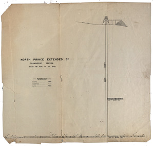
Plan, North Prince Extended Co
... prince extended mining company gold Transverse section ...Transverse section of the North Prince Extended Co,north prince extended, mining company, gold -
 Federation University Historical Collection
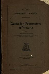
Book, Guide for Prospectors in Victoria, 1931, 1931
... to prospect of fossick. mining baragwanath gold prospector geology ...The handbook was intended for those with little experience who wanted to prospect of fossick.Grey soft covered book of 90 pages. Includes fold out map of a portion of Victoria showing auriferous areas and mineral localities. Also show Counties of Victoria and localities of minerals such as tin, antimony, copper, silver lead, Malybdenite, tungsten ores, manganese, platinum, osmiridium and iron. Chapter heading s include: working alluvial deposits, equipment, geology of Victoria, gold deposits, quartz reefs, indicators, economic minerals, assistance to prospectors, Miners' Right, mining bye-law, mining leases, forest regulations and glossary. Descriptions are given of a god dish, puddling tub, cradle, puddling machine, ground sluicing, boring, windlass, whim, hand dollying, sweeping, California pump, and wing dam.mining, baragwanath, gold, prospector, geology, quartz reefs, alluvial deposits, indicators, victorian goldfields, miners rights, mining leases, forest regulations, sluicing, sluice box, puddling machine, miner's cradle, whim, whip, california pump, gold nuggets, saddle reef, ballarat indicators, state batteries -
 Federation University Historical Collection
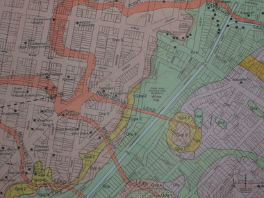
Plan, Ballarat Goldfield - Geological Survey of Victoria, 1981, 1981
... ballarat geology geological gold nuggets mining mining companies ...Coloured geological plan showing the Ballarat goldfields. It includes coloured scales and nuggets from the Ballarat Goldfield. It also shows leads and mines.ballarat, geology, geological, gold nuggets, mining, mining companies, gold leads -
 Federation University Historical Collection
Booklet - Report, Department of Mines Annual Report, 1950, c1950
... . gouley mining coal gold silver geology boiler inspection leasing ...Thirty six page foolscap booklet with some black and white photographic image. It includs statistics relating to the mining industry. Images include Limestone Quarry at Cave Hill, Lilydale; Golden Retriever nuggett; The Wedderburn Dog nuggett; Moning Star Mine, Wood's Point; shallow drilling; penicillin tanks; Mines Department Laboratory; Charging; Aurora Mine, Daylesford; Hattietville Dredge; North Deborah Mine, Bendigo; Central Victorian Dredge, Strangwaysj.g. gouley, mining, coal, gold, silver, geology, boiler inspection, leasing, gold buyers act, lilydale, fireclay, harrietville dredge, aurora mine daylesford, williams reward mine daylesford, strangways dredge, north deborah mine bendigo, statistics, bendigo mine, department of mines victoria, annual report, statistics relating to mining industry -
Bendigo Historical Society Inc.
Document - CENTRAL DEBORAH GOLD MINE: MINES ALONG THE DEBORAH ANTICLINE
... BENDIGO Mining deborah gold mines Deborah Gold mines Plan of reef ...Plan of reef line showing the location of the Deborah Gold Mines. Drawn by Philip Wilkin for the 60th anniversary of the closing of the Central Deborah Gold Mine.bendigo, mining, deborah gold mines, deborah gold mines -
 Bendigo Historical Society Inc.
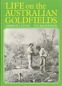
Book - LIFE ON THE AUSTRALIAN GOLDFIELDS, 1984
... Inc. History House 11 Mackenzie Street Bendigo goldfields GOLD ...Life on the Australian Goldfields 221 pages with photos and illustrations.Derrick I Stone, Sue MacKinnongold, goldfields, living conditions, bendigo, goldfields, mining techniques, gold discovery -
 Bendigo Historical Society Inc.
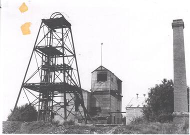
Photograph - DEBORAH GOLD MINE 1930'S
... BENDIGO Mining deborah gold mine Black and white photograph, copy ...Black and white photograph, copy, of the Big Deborah Gold Mine, possibly taken in the 1930's. Deborah mine was near the junction of Abel and Adam Street, Golden Square. Image shows the mine site, a square brick chimney on the extreme RH side, engine room and stamper sheds in the middle and steel poppet head on LH side. Colour photo of Big Deborah, minus less the winding wheels at the top of the poppet legs.bendigo, mining, deborah gold mine -
 Bendigo Historical Society Inc.
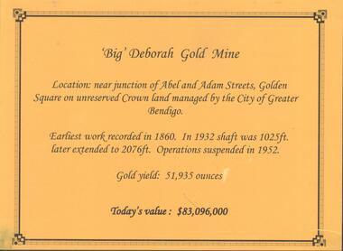
Photograph - DEBORAH GOLD MINE, GOLDEN SQUARE
... BENDIGO Mining deborah gold mine Information display card ...Information display card regarding the 'Big' Deborah Gold Mine, located near the junction of Abel and Adam Street, Golden Square. Earliest work recorded 1860. Shaft 2076 feet. Operations suspended in 1952. Gold yield 51,935 ounces. Battery shed still on site containing a 5 head stamper which was originally a 20 head stamper. The battery was manufactured by Horwood's Foundry, Bendigo. Photos of mine site taken in 2012: a.Engine room concrete footings, iron work visible. Pepper corn trees in background. Pampas grass in foreground. Steel mesh fence on RH side, enclosing the poppet head site. b. Concrete footings, peppercorn tree in background. c. Corrugated iron shed constructed over the stampers. Steel mesh front. d. Steel poppet head, no winding wheel at top. Pampas grass in foreground. e.. Stamper shed and steel poppet legs in background enclosing dilapidated wooden poppet head legs. f. Close up image of weights in stamper room g.Winding wheel on stampers h.Looking upwards to top of stampersbendigo, mining, deborah gold mine -
 Bendigo Historical Society Inc.
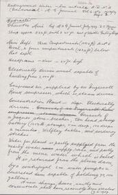
Document - ALBERT RICHARDSON COLLECTION: CHEWTON MINE
... BENDIGO Mining chewton gold mine One page document, extracts from ...One page document, extracts from M.G. Journal Vol 6, No. 3, 1958/59, Page 3 and M.G. Journal 1939. Chewton Mine shaft approx 523 feet, south and 45 feet east of Wattle Gully shaft. .Extract includes detail of the main shaft, headframe, winch, compressed air, concentration plant, water for plant. Ten head stamp battery, 1250 lb stamps 5 in drop, 100 drops a minute, Wilfley tables and corduroy strakes. A new change house, smithy and concentrate shed have recently been erected (9.6.1939)bendigo, mining, chewton gold mine