Showing 2594 items
matching parts of buildings or structures
-
 Seaworks Maritime Museum
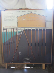
Diagram
Cross section of wharves and steel framed sheds built along the Yarra river between the 1920s and 1960s. The South Melbourne side of the Yarra River is reclaimed swamp land. Without a solid foundation for the construction of the wharves and transit sheds, extended piles were sunk into the mud to support the wharf and shed structures. An example of this design may be found at 5 South Wharf which was built in the 1930s. The transit sheds gave shelter for cargo while waiting to be loaded onto a ship or to be collected by truck after being unloaded from a ship. The transit shed became surplus to requirements with the introduction of containers.Wooden diagram of a transit shed featuring a shed sitting atop mud with some water. It shows the splices sitting in the mud to support the shed. "Steel Frames Transit Shed/ 15 South Wharf/ Model of Typical wharf construction/ of 1940- made for the opening of/ the "new" 15 South wharf shed (1944),/ Note the deep piles and elevated/ rear of the shed to allow for the truck/ trays./ This shed feature disappeared/ from port construction with the/ coming of the container era/ reinforced wharf apron/ 3 ton travelling crane/ reinforced concrete shed floor/ concrete road/ water level/ concrete pile cap/ cradled piles/ timber pile splices/ mud/ mild steel pile splices/ 110 ft pile" "On loan from Port of Melbourne Authority" -
 Kiewa Valley Historical Society
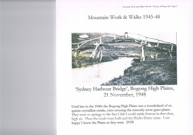
Journal - Reference, Mountain Work and Walks 1945-48,The Joy of Being Alive, circa 1950s
This journal detailing the author and friends walks and observations together with black and white photographs of the Kiewa Valley and the Bogong high plains regions during various "walks during the years 1945 to 1948. These walks were undertaken during the various Hydro - electricity generating plants and infra structures were being installed. It relays how the walker and adventurer enjoyed the pristine Alpine regions of Victoria. The wilderness and higher sense of adventure encountered by the author and his "walking party" is now no longer that intense. The isolation of the region was, at that time, still a barrier for the casual adventurer and required a dedication of the "pioneer" mountain walker.The significance of this journal is that both the photographs and accounts of those intrepid adventurers walking throughout the Victorian Alps and the Bogong High Plains details the countryside in one of the remaining years of relative pristine and minimal "tourist" developed regions of rural Victorian. The necessity of greater electrical power supply to the rapidly growing demand from cities and larger towns, post World War II immigration, had resulted in drastic changes to the infrastructure of the Victorian Alpine regions and particularly the Kiewa Valley. The photographs and the written accounts of the "adventurers" in this journal presents the last phases of the " Australian rough outback environment" and also the typical "bush wise" city/town dweller that although lived in towns and cities still had the adventurers heart of their fore fathers.This item has been photocopied by the author of his journal, consisting 27 pages of A4 size paper. A covering letter by the author is at the front of this loose leafed journal. The journal is bound in a yellow plastic cover with spirals. At the back is a 2 page biography of Myrtle Emily (Grigg) Deamer 1922-2006, then a photo of Meg with baby Bryn and son Tony followed by a letter from David BottomleyThe author's correspondence and covering letter has his signature "D Bottomley"alpine country, bush walking, bogong mountain, alpine adventures -
 Marysville & District Historical Society
Photograph (Item) - Black and white photograph, Unknown
A digital copy of a black and white photograph of the Buxton Hotel in Buxton. The Buxton Hotel was built by William Burchall, probably in the late 1870s. The first owner, who also had land locally, was Frederick Nichols (1833-1904). The Buxton Hotel is located directly opposite the General Store. It was fronted with two huge oak trees and bordered and backed by large pine trees. It was a weatherboard structure with a painted corrugated iron roof. Old split wood shingles were covered by corrugated iron, which overlaid the shingles to make the roof watertight. The wooden shingles date back to the 1850s.A digital copy of a black and white photograph of the Buxton Hotel in Buxton.buxton, victoria, australia, buxton hotel, photograph, william burchall, frederick nichols -
 Marysville & District Historical Society
Photograph (Item) - Black and white photograph, Mark James Daniel, 1904
A digital copy of a black and white photograph of Nichol's Buxton Hotel in Buxton. The Nichol's Buxton Hotel was built by William Burchall, probably in the late 1870s. The first owner, who also had land locally, was Frederick Nichols (1833-1904). The Buxton Hotel is located directly opposite the General Store. It was fronted with two huge oak trees and bordered and backed by large pine trees. It was a weatherboard structure with a painted corrugated iron roof. Old split wood shingles were covered by corrugated iron, which overlaid the shingles to make the roof watertight. The wooden shingles date back to the 1850s.A digital copy of a black and white photograph of Nichol's Buxton Hotel in Buxton.buxton, victoria, australia, buxton hotel, nichol's buxton hotel, photograph, william burchall, frederick nichols -
 Federation University Historical Collection
Photograph - Photograph - Black and White, Ballarat Civic Hall, c1965
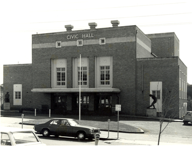
The City of Ballarat unanimously resolved to erect a Civic Hall in 1951. The architects, Gordon Murphy, of Melbourne, and H.L. and L.J. Colburn, of Ballarat, were commissioned in 1952. The Council constructed the foundations and footings for the building under the supervision of the former City engineer, Mr L.H. Finch, in 1953. These footings are of massed concrete. The design for the building took advantage of the cross fall of the land, providing for the Small Hall to be entered from the Doveton Street frontage through a foyer under the Main Stage, the structure is steel with brick panels, with accommodation for 1,592 persons in the Main Hall and 440 persons in the Lower Hall. Black and white photograph of a brick building known as Ballarat Civic Hall. It is located on the corner of Mair Street and Doveton Street North. The Shakespeare statue out the front of the building was unveiled on 17 November 1960. ballarat civic hall, civic hall, colburn, finch -
 Robin Boyd Foundation
Document - Manuscript, Robin Boyd, Under Tension, 1963
Boyd argues that modern architecture has triggered a necessity for greater harmony between architects and engineers. Boyd describes the architectural qualities of tension structures through an analysis of several case studies including projects by Frei Otto and Boyd's own house at Walsh St. Being a relatively new concept, Boyd criticises the neglect towards smaller buildings in this structural system, and also highlights some of its shortcomings. A 2-page letter from 'Arthur' (surname unknown) at the University of Melbourne's Department of Civil Engineering provides feedback to Boyd on his analyses of the chosen case studies.Original manuscript of article published in The Architectural Review Vol.134, No.801, November 1963, pp. 324 - 334. This draft was returned with covering letter from: ‘Arthur’ (AJF) Melbourne Uni. Dept Civil Engineering. Typewritten (c copy), foolscap, 14 (+2 quarto letter) pagesMinor handwritten editsengineering, tensile structure, master-designer, bernard lafaille, zagreb french pavilion, matthew nowicki, livestock pavilion, frei otto, paul rudolph, florida house, bill irwin, kevin borland, peter mcintyre, john and phyllis murphy, yuncken freeman, sidney myer music bowl, eero saarinen, yale hockey rink, edward d. stone, brussels u.s. fair pavilion, boston arts centre, walsh street, robin boyd, manuscript -
 Kew Historical Society Inc
Photograph - Cosy Five Roomed Rough Cast Bungalow, Kew, J E Barnes, c.1920
Subdivision plans are historically important documents used as evidence of the growth of suburbs in Australia. They frequently provide information about when the land was sold on which a built structure was subsequently constructed as well as evidence relating to surveyors and real estate and financial agents. The numerous subdivision plans in the Kew Historical Society's collection represent working documents, ranging from the initial sketches made in planning a subdivision to printed plans on which auctioneers or agents listed the prices for which individual lots were sold. In a number of cases, the reverse of a subdivision plan in the collection includes a photograph of a house that was also for sale by the agent. These photographs provide significant heritage information relating house design and decoration, fencing and household gardens. The photograph is also aesthetically significant as it was taken by J. E. Barnes, a nationally significant photographer. He was the most important photographer to have worked in Kew. He was active as a photographer in the district from c.1906 until his death in 1921. Best known as 'the Embarkation Photographer' (see the Australian War Memorial collection), Josiah Earl Barnes was also the official photographer employed by the Borough (and later Town, then City) of Kew. He clearly also completed commercial jobs for local businesses, as is the case in this photograph of a house for a local real estate and financial agent. A modest weatherboard house with rough-cast rendered walls. The gabled entrance incorporates elements of the Japanese aesthetic. The strong lines of the dark timber gable are reinforced by the colour and shape of the pickets in the fence. In contrast to an earlier period, the chimneys appear truncated. The use of extensive double-hung sash windows in the front rooms reflects a new interest in light in houses. The use of separate sunshades over windows in an earlier period is here replaced by an extension of the roofline over the window. The photographer Josiah Barnes died in 1921; so, the photograph of the house must predate this date. The location of the house, which was advertised for sale, has to date not been identified. Illegible inscription. Photographer's information on mount.josiah earl barnes, j e barnes, photography - kew, interwar housing - victoria, 1920s housing - kew -
 Kew Historical Society Inc
Photograph - 2 Young Street, Kew, Paramount Photos, 1920s
Subdivision plans are historically important documents used as evidence of the growth of suburbs in Australia. They frequently provide information about when the land was sold on which a built structure was subsequently constructed as well as evidence relating to surveyors and real estate and financial agents. The numerous subdivision plans in the Kew Historical Society's collection represent working documents, ranging from the initial sketches made in planning a subdivision to printed plans on which auctioneers or agents listed the prices for which individual lots were sold. In a number of cases, the reverse of a subdivision plan in the collection includes a photograph of a house that was also for sale by the agent. These photographs provide significant heritage information relating house design and decoration, fencing and household gardens.A prepossessing, large home constructed in the Arts and Crafts style. Located on the banks of the Yarra at 2 Young Street, Kew overlooking the factories of Richmond, the design of the house takes account of the gradient with the addition of a level below the front entrance. The elegant roof includes a number of projecting gables and dormers. The gables are typically half-timbered and rendered. In addition to the asymmetrically placed portico, there are at least two open verandas, supported by timber pillars and with roofs that reflect the overall pitch of the roof of the housereal estate photographs, 2 young street - kew -
 Kew Historical Society Inc
Photograph - 8 roomed DF Brick Villa, Kew, J E Barnes, c.1920
Subdivision plans are historically important documents used as evidence of the growth of suburbs in Australia. They frequently provide information about when the land was sold on which a built structure was subsequently constructed as well as evidence relating to surveyors and real estate and financial agents. The numerous subdivision plans in the Kew Historical Society's collection represent working documents, ranging from the initial sketches made in planning a subdivision to printed plans on which auctioneers or agents listed the prices for which individual lots were sold. In a number of cases, the reverse of a subdivision plan in the collection includes a photograph of a house that was also for sale by the agent. These photographs provide significant heritage information relating house design and decoration, fencing and household gardens. The photograph is of additional aesthetic significance as it was photographed by J. E. Barnes. Josiah Earl Barnes is a nationally significant photographer. He was also the most important photographer to have worked in Kew. He was active as a photographer in the district from c.1906 until his death in 1921. Best known as 'the Embarkation Photographer' (see the Australian War Memorial collection), J. Earl Barnes was also the official photographer employed by the Borough (and later Town, then City) of Kew. He clearly also completed commercial jobs for local businesses, as is the case in this photograph of a house for a local real estate and financial agent.A photograph, mounted on board of a double fronted Federation-era brick villa in Kew, photographed for a local real estate agent and financier by J. E. Barnes of Kew. On the reverse of the photograph is a subdivision plan for the Normanby Estate, East Kew - 2016.0039.1. As can be seen from the image, there is a large tear on the surface of the photograph.The brown card on which the photograph is mounted includes the following handwritten description, which may aid the identification of the house: "Kew, 3 minutes from tram, 8 roomed DF Brick Villa, tile roof including two attics, sleepout, bathroom, heater, E Light, Entrance Hall, double doors, leadlights, laundry, garden, lawns, land 75 x 170, 1975 pounds". Also photographers inscription on mount, lower left: J. E. Barnes / Photo / Phone 1966 Haw. KEW.j. e. barnes, josiah earl barnes, j. earl banes - photographer, architecture - federation style, houses - kew, real estate photographs -
 Vision Australia
Badge - Object, Daisy consortium anniversary badge, 2011
The DAISY consortium was established in 1996 to develop an industry standard for the emerging digital book market. It's partners recognised that by incorporating the same features when constructing digital recordings with text, and using an established structure, publications could be usefully exchanged and sent around the world. In 2011 the consortium celebrated it's 15th anniversary and commemoration badges were sent to it's members, which included NILS (the production and library divisions of the Royal Blind Society of NSW, Vision Australia Foundation and RVIB). The badge has a blue swirl above and below the words 'daisy consortium' with '15th anniversary' at the base.Small badge with black writing on white backgrounddaisy consortium 15th anniverary badges, national information library service -
 Wodonga & District Historical Society Inc
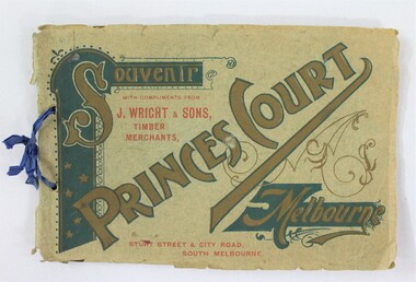
Booklet - Souvenir Booklet for Princes Court Amusement Park, Melbourne c. 1904-1905
Princes Court was an amusement park in Melbourne, located on St Kilda Road. Established in 1904, it closed its doors in 1909 after poor ticket sales due to Melbourne's temperamental weather. The park featured a toboggan ride and water chute ride where patrons inside open carriages were plunged down sloping structures from a height at great speeds. The park's other facilities and activities included a rifle range, a tug of war game, a Japanese tea house, a wine bar, a variety show, an open air cinema, and roller skating and bicycle races.This item contributes to our understanding of social life and recreation in early twentieth century Victoria. A souvenir booklet for Princes Court, an amusement park in Melbourne, printed for the years 1904-5. The booklet features photographs of the park's attractions, and advertisements for local businesses in Melbourne. wodonga, melbourne, princes park, amusement park, rides, fair, fairground, japanese tea house, st kilda -
 Melbourne Legacy
Booklet, The National War Memorial of Victoria. The Shrine of Remembrance. Souvenir Booklet, 1947
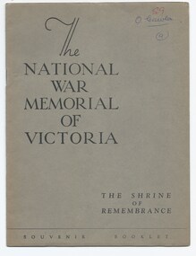
The booklet shows important aspects of the Shrine, 'one of the greatest of the war memorials erected in various parts of the world'. 'The purpose of this imposing structure is set out in the simple words quoted on the eastern wall of the Shrine of Remembrance itself- "This memorial was erected by a grateful people to the honoured memory of the men and women of Victoria who served the Empire in the Great War of 1914-18." The booklet outlines parts of the Shrine including the Battle Honour Discs, the Porticos, the Stone of Remembrance, the Inner Shrine, the Crypt and the Ray of Light. The document was in a file with other documents concerning the Shrine and it's history (01181 - 01190).A record of the Shrine of Remembrance. There was an effort to record historical events for the "Archive Committee" which collected this and other documents relating to the Shrine together in a file (see items 01181 - 01190)A 16 page of booklet of buff paper in a dark grey brown cover describing the Shrine in photos and black print.memorial, shrine of remembrance -
 Melbourne Legacy
Document - Document, report, (H52) The Way Ahead: a paper approved by Board of Management for dissemination to all members of the Legacy Club of Melbourne, 1979
Supplement to the Melbourne Legacy Bulletin No. 2463 which discusses how the Club should be structured after 1979, dated 27/6/79. It notes that the number of children being cared for was diminishing rapidly and immediate action should be taken with regard to the recruitment of Legatees and the adjustment of Branch boundaries. In 1978 the number of Junior Legatees had dropped to 3103 and by 1988 this figure was expected to be 280. However the 16,654 Legacy widows in 1978 was expected to increase to 24,700 in 1993. The work was split between 15 Branches, but the adjustment of Branch boundaries was not investigated in detail. Resulted from a Review CommitteeIllustrates the changing role of Melbourne Legacy during the twentieth century.Pale blue foolscap copy paper x 4 pages, printed both sides.'H52' in blue ballpoint on first page. Date crossed out in red ballpoint.organisation structure, review committee, review, objectives -
 Bacchus Marsh & District Historical Society
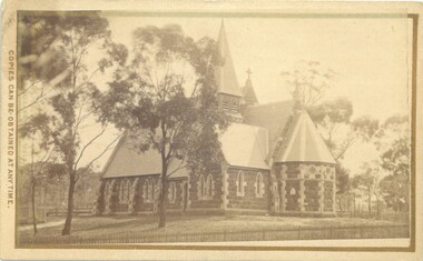
Photograph, Holy Trinity Church Bacchus Marsh 1883
The Holy Trinity Anglican Church in this location was first opened in 1877. An earlier nearby prefabricated Church building known as the 'Iron Church' had served as the Anglican place of worship in Bacchus Marsh from around 1855 until 1877. The 1877 sandstone Church with a slate roof was intended as a permanent structure for Anglican worship in Bacchus Marsh and still stands in 2024 and continues to function as an Anglican Church. The building was designed by Frederick Wyatt and is described as early English Gothic in style. It was opened on 5 June 1877 by Bishop Moorhouse of Melbourne. The sandstone was acquired from Grant's quarry at Maddingley.Small sepia unframed photograph on card with gold border framing photograph. Housed in the Jeremeas Family Album, which contains photographs of Bacchus Marsh and District in 1883 by Stevenson and McNicoll. The photograph depicts the recently constructed Anglican Holy Trinity Church in Gisborne Road, Bacchus Marsh. The view of the building is from Gisborne Road looking west. From this angle the rear and southern side of the building can be seen. A picket fence along the entrance to the Church grounds can be seen in the foreground.On the front: Stevenson & McNicoll. Photo. 108 Elizabeth St. Melbourne. COPIES CAN BE OBTAINED AT ANY TIME. On the back: LIGHT & TRUTH inscribed on a banner surmounted by a representation of the rising sun. Copies of this Portrait can be had at any time by sending the Name and Post Office Money Order or Stamps for the amount of order to STEVENSON & McNICOLL LATE BENSON & STEVENSON, Photographers. 108 Elizabeth Street, MELBOURNE churches bacchus marsh, holy trinity anglican church bacchus marsh, holy trinity church of england bacchus marsh, stevenson and mcnicoll 1883 photographs of bacchus marsh and district -
 Bacchus Marsh & District Historical Society
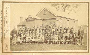
Photograph, Coimadai State School teachers and students 1883
Coimadai is a rural community located 10km north of Bacchus Marsh. The Coimadai School was opened in 1862. It was at first entirely funded by the local residents in the area. In these early years it was known as the Pyrete School after the nearby creek of that name. The building shown in this 1883 image was constructed in 1872 and replaced an earlier wooden structure. Over time the Coimadai School became a government funded and administered school. A famous pupil to attend the school was John Cain Senior, Premier of Victoria in the 1940s and 1950s, who attended the school for one year in 1893. This school still operates as a state primary school.Small sepia unframed photograph on card with gold border framing photograph. Housed in the album, 'Photographs of Bacchus Marsh and District in 1883 by Stevenson and McNicoll'. The image is a large group portrait of the pupils of the Coimadai State School and their two male teachers. There are about 60 pupils. The older children are standing in rows and a younger group of pupils is seated on forms or benches in front of them. One teacher stands on the right of the group of pupils and the other is on the left. The School building can be seen in the background.On the front: Stevenson & McNicoll. Photo. 108 Elizabeth St. Melbourne. COPIES CAN BE OBTAINED AT ANY TIME. On the back: LIGHT & TRUTH inscribed on a banner surmounted by a representation of the rising sun. Copies of this Portrait can be had at any time by sending the Name and Post Office Money Order or Stamps for the amount of order to STEVENSON & McNICOLL LATE BENSON & STEVENSON, Photographers. 108 Elizabeth Street, MELBOURNE schools, schools coimadai vic., stevenson and mcnicoll 1883 photographs of bacchus marsh and district -
 Wodonga & District Historical Society Inc
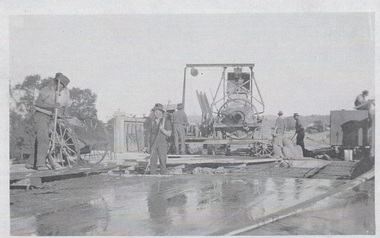
Photograph - Construction of Wodonga Creek Bridge, 1920
The bridge over Wodonga Creek was opened on Friday 20th October 1922 by the Minister For Public Works Mr Frank. The erection of the bridge was carried out by Mr L Carr, of Brighton. The new concrete bridge was a little more than 500 feet long and consisted of 12 spans. The decking was supported by a number of steel girders, each weighing approximately seven tons. The whole bridge was supported by rows of three cylinders, sunk to a depth of 26ft below the summer water level. The original estimated cost of the structure was £20,000, but with the extras added during construction this amount was exceeded.These photos are significant because the capture the construction of an important bridge between Albury and Wodonga.Three black and white photographs taken during the construction of the new bridge over the Wodonga Creek in 1920.wodonga bridges, wodonga creek -
 Kew Historical Society Inc
Photograph - Construction of the Eastern Freeway (F19), Ron Setford, March 1972
Ron Setford and his wife Grace Setford lived in Tanner Avenue, East Kew, from c.1946 to c.1995. A keen photographer, he recorded the changing face of Kew over a 20 year period. Apart from 30 photographs of built structures and places in Kew dating from 1960 and 1961, 145 of his 35mm colour slides chronicle the development of the F19 (later renamed Eastern) Freeway through the Yarra Valley in Kew over a five year period from c.1972 to c.1977. This important collection was donated to the Society by his granddaughter in 2025.This collection of 175 35mm slides is of local and statewide significance, owing to its subject matter, particularly the major development of road transport infrastructure during the 1970s with the construction of the Eastern Freeway. The photographer also took care to annotate and date most of his slides which enable the researcher to pinpoint temporal and spatial locations.Photograph of works involved in construction of the F19 (now Eastern) Freeway. The photo shows how construction sometimes took account of key environmental features; in this case the Kew Billabong."Eastern Freeway / "The Lagoon" to be saved at all costs"ron setford, eastern freeway, f19 freeway, kew billabong -
 Kew Historical Society Inc
Photograph - Construction of the Eastern Freeway (F19), Ron Setford, March 1972
Ron Setford and his wife Grace Setford lived in Tanner Avenue, East Kew, from c.1946 to c.1995. A keen photographer, he recorded the changing face of Kew over a 20 year period. Apart from 30 photographs of built structures and places in Kew dating from 1960 and 1961, 145 of his 35mm colour slides chronicle the development of the F19 (later renamed Eastern) Freeway through the Yarra Valley in Kew over a five year period from c.1972 to c.1977. This important collection was donated to the Society by his granddaughter in 2025.This collection of 175 35mm slides is of local and statewide significance, owing to its subject matter, particularly the major development of road transport infrastructure during the 1970s with the construction of the Eastern Freeway. The photographer also took care to annotate and date most of his slides which enable the researcher to pinpoint temporal and spatial locations.Photograph of works involved in construction of the F19 (now Eastern) Freeway. The photo shows how construction sometimes took account of key environmental features; in this case the Kew Billabong."Eastern Freeway / Sept 72"ron setford, eastern freeway, f19 freeway -
 Kew Historical Society Inc
Photograph - Construction of the Eastern Freeway (F19), Ron Setford, March 1972
Ron Setford and his wife Grace Setford lived in Tanner Avenue, East Kew, from c.1946 to c.1995. A keen photographer, he recorded the changing face of Kew over a 20 year period. Apart from 30 photographs of built structures and places in Kew dating from 1960 and 1961, 145 of his 35mm colour slides chronicle the development of the F19 (later renamed Eastern) Freeway through the Yarra Valley in Kew over a five year period from c.1972 to c.1977. This important collection was donated to the Society by his granddaughter in 2025.This collection of 175 35mm slides is of local and statewide significance, owing to its subject matter, particularly the major development of road transport infrastructure during the 1970s with the construction of the Eastern Freeway. The photographer also took care to annotate and date most of his slides which enable the researcher to pinpoint temporal and spatial locations.Kilby Rd, Willsmere Park on left"Eastern Freeway / Kilby Road / Nov 72"ron setford, eastern freeway, f19 freeway, willsmere park, kilby road -
 Kew Historical Society Inc
Photograph - Construction of the Eastern Freeway (F19), Ron Setford, March 1972
Ron Setford and his wife Grace Setford lived in Tanner Avenue, East Kew, from c.1946 to c.1995. A keen photographer, he recorded the changing face of Kew over a 20 year period. Apart from 30 photographs of built structures and places in Kew dating from 1960 and 1961, 145 of his 35mm colour slides chronicle the development of the F19 (later renamed Eastern) Freeway through the Yarra Valley in Kew over a five year period from c.1972 to c.1977. This important collection was donated to the Society by his granddaughter in 2025.This collection of 175 35mm slides is of local and statewide significance, owing to its subject matter, particularly the major development of road transport infrastructure during the 1970s with the construction of the Eastern Freeway. The photographer also took care to annotate and date most of his slides which enable the researcher to pinpoint temporal and spatial locations. Kilby Rd, Willsmere Park on left Kilby Rd, Willsmere Park on left" E Freeway Nov 1972"ron setford, eastern freeway, f19 freeway, willsmere park, kilby road -
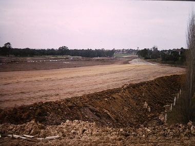
 Kew Historical Society Inc
Photograph - Construction of the Eastern Freeway (F19), Ron Setford, March 1972
Ron Setford and his wife Grace Setford lived in Tanner Avenue, East Kew, from c.1946 to c.1995. A keen photographer, he recorded the changing face of Kew over a 20 year period. Apart from 30 photographs of built structures and places in Kew dating from 1960 and 1961, 145 of his 35mm colour slides chronicle the development of the F19 (later renamed Eastern) Freeway through the Yarra Valley in Kew over a five year period from c.1972 to c.1977. This important collection was donated to the Society by his granddaughter in 2025.This collection of 175 35mm slides is of local and statewide significance, owing to its subject matter, particularly the major development of road transport infrastructure during the 1970s with the construction of the Eastern Freeway. The photographer also took care to annotate and date most of his slides which enable the researcher to pinpoint temporal and spatial locations."Eastern Freeway 6/72 / Rock fill in old river bed"ron setford, eastern freeway, f19 freeway -
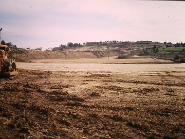
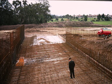
 Kew Historical Society Inc
Photograph - Construction of the Eastern Freeway (F19), Ron Setford, March 1972
Ron Setford and his wife Grace Setford lived in Tanner Avenue, East Kew, from c.1946 to c.1995. A keen photographer, he recorded the changing face of Kew over a 20 year period. Apart from 30 photographs of built structures and places in Kew dating from 1960 and 1961, 145 of his 35mm colour slides chronicle the development of the F19 (later renamed Eastern) Freeway through the Yarra Valley in Kew over a five year period from c.1972 to c.1977. This important collection was donated to the Society by his granddaughter in 2025.This collection of 175 35mm slides is of local and statewide significance, owing to its subject matter, particularly the major development of road transport infrastructure during the 1970s with the construction of the Eastern Freeway. The photographer also took care to annotate and date most of his slides which enable the researcher to pinpoint temporal and spatial locations." Eastern Freeway 6/72 / Embankment approx half height"ron setford, eastern freeway, f19 freeway -
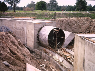 Kew Historical Society Inc
Photograph - Construction of the Eastern Freeway (F19), Ron Setford, March 1972
Ron Setford and his wife Grace Setford lived in Tanner Avenue, East Kew, from c.1946 to c.1995. A keen photographer, he recorded the changing face of Kew over a 20 year period. Apart from 30 photographs of built structures and places in Kew dating from 1960 and 1961, 145 of his 35mm colour slides chronicle the development of the F19 (later renamed Eastern) Freeway through the Yarra Valley in Kew over a five year period from c.1972 to c.1977. This important collection was donated to the Society by his granddaughter in 2025.This collection of 175 35mm slides is of local and statewide significance, owing to its subject matter, particularly the major development of road transport infrastructure during the 1970s with the construction of the Eastern Freeway. The photographer also took care to annotate and date most of his slides which enable the researcher to pinpoint temporal and spatial locations."Eastern Freeway 6/72 / Kew Main Drain extension under freeway"ron setford, eastern freeway, f19 freeway -
 Kew Historical Society Inc
Photograph - Construction of the Eastern Freeway (F19), Ron Setford, March 1972
Ron Setford and his wife Grace Setford lived in Tanner Avenue, East Kew, from c.1946 to c.1995. A keen photographer, he recorded the changing face of Kew over a 20 year period. Apart from 30 photographs of built structures and places in Kew dating from 1960 and 1961, 145 of his 35mm colour slides chronicle the development of the F19 (later renamed Eastern) Freeway through the Yarra Valley in Kew over a five year period from c.1972 to c.1977. This important collection was donated to the Society by his granddaughter in 2025.This collection of 175 35mm slides is of local and statewide significance, owing to its subject matter, particularly the major development of road transport infrastructure during the 1970s with the construction of the Eastern Freeway. The photographer also took care to annotate and date most of his slides which enable the researcher to pinpoint temporal and spatial locations."Eastern Freeway 6/72 / Willsmere Park flood underpass"ron setford, eastern freeway, f19 freeway -
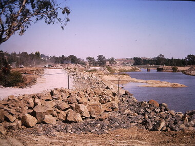
 Kew Historical Society Inc
Photograph - Construction of the Eastern Freeway (F19), Ron Setford, March 1972
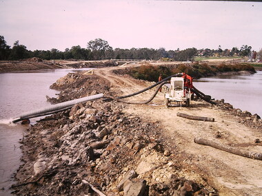
Ron Setford and his wife Grace Setford lived in Tanner Avenue, East Kew, from c.1946 to c.1995. A keen photographer, he recorded the changing face of Kew over a 20 year period. Apart from 30 photographs of built structures and places in Kew dating from 1960 and 1961, 145 of his 35mm colour slides chronicle the development of the F19 (later renamed Eastern) Freeway through the Yarra Valley in Kew over a five year period from c.1972 to c.1977. This important collection was donated to the Society by his granddaughter in 2025.This collection of 175 35mm slides is of local and statewide significance, owing to its subject matter, particularly the major development of road transport infrastructure during the 1970s with the construction of the Eastern Freeway. The photographer also took care to annotate and date most of his slides which enable the researcher to pinpoint temporal and spatial locations.Photograph of works involved in construction of the F19 (now Eastern) Freeway. The photo shows how construction sometimes took account of key environmental features; in this case the Kew Billabong."Eastern Freeway / pumping out of old river"ron setford, eastern freeway, f19 freeway -
 Ballarat Heritage Services
Photograph - Digital photographs, L.J. Gervasoni, Former Koroit Railway Station, 2016
The Koroit railway station began operations in 1889, with a brick building replacing an original timber structure in 1907.Once a major junction station between the Port Fairy Line and the branch to Penshurst and Hamilton, train services to Koroit ceased in 1977. The track at Koroit has long been removed. The station itself however has been preserved with heritage funding keeping it looking close to its working condition. The large brick station building, platform and goods shed have all been retained and provide a good example of a major junction station on a former railway line.Digital images of a brick railway station at Koroit, Victoria. transport, rail trail, koroit, koroit railway station, buildings -
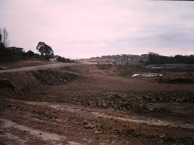
 Kew Historical Society Inc
Photograph - Construction of the Eastern Freeway (F19), Ron Setford, March 1972
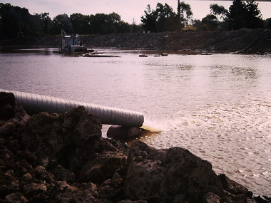
Ron Setford and his wife Grace Setford lived in Tanner Avenue, East Kew, from c.1946 to c.1995. A keen photographer, he recorded the changing face of Kew over a 20 year period. Apart from 30 photographs of built structures and places in Kew dating from 1960 and 1961, 145 of his 35mm colour slides chronicle the development of the F19 (later renamed Eastern) Freeway through the Yarra Valley in Kew over a five year period from c.1972 to c.1977. This important collection was donated to the Society by his granddaughter in 2025.This collection of 175 35mm slides is of local and statewide significance, owing to its subject matter, particularly the major development of road transport infrastructure during the 1970s with the construction of the Eastern Freeway. The photographer also took care to annotate and date most of his slides which enable the researcher to pinpoint temporal and spatial locations.Photograph of works involved in construction of the F19 (now Eastern) Freeway involving rerouting the River Yarra in Kew."Eastern Freeway / pumping out old river bed"ron setford, eastern freeway, f19 freeway -
![Photograph - Construction of the F19 [Eastern Freeway], Ron Setford, January 1973](/media/collectors/550653872162f11fb04854aa/items/67fb2edfa8240b7bcaf34522/item-media/67fb2f06a8240b7bcaf34747/item-fit-380x285.jpg) Kew Historical Society Inc
Kew Historical Society IncPhotograph - Construction of the F19 [Eastern Freeway], Ron Setford, January 1973
Ron Setford and his wife Grace Setford lived in Tanner Avenue, East Kew, from c.1946 to c.1995. A keen photographer, he recorded the changing face of Kew over a 20 year period. Apart from 30 photographs of built structures and places in Kew dating from 1960 and 1961, 145 of his 35mm colour slides chronicle the development of the F19 (later renamed Eastern) Freeway through the Yarra Valley in Kew over a five year period from c.1972 to c.1977. This important collection was donated to the Society by his granddaughter in 2025.This collection of 175 35mm slides is of local and statewide significance, owing to its subject matter, particularly the major development of road transport infrastructure during the 1970s with the construction of the Eastern Freeway. The photographer also took care to annotate and date most of his slides which enable the researcher to pinpoint temporal and spatial locations."Freeway at Willsmere u/pass / INF F9 125 SOC 2pm"ron setford, eastern freeway, f19 freeway -
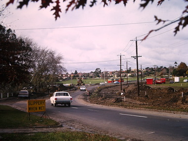
![Photograph - Construction of the F19 [Eastern Freeway], Ron Setford, November 1972](/media/collectors/550653872162f11fb04854aa/items/67fb2de2a8240b7bcaf334be/item-media/67fb2e09a8240b7bcaf3366d/item-fit-380x285.jpg) Kew Historical Society Inc
Kew Historical Society IncPhotograph - Construction of the F19 [Eastern Freeway], Ron Setford, November 1972
Ron Setford and his wife Grace Setford lived in Tanner Avenue, East Kew, from c.1946 to c.1995. A keen photographer, he recorded the changing face of Kew over a 20 year period. Apart from 30 photographs of built structures and places in Kew dating from 1960 and 1961, 145 of his 35mm colour slides chronicle the development of the F19 (later renamed Eastern) Freeway through the Yarra Valley in Kew over a five year period from c.1972 to c.1977. This important collection was donated to the Society by his granddaughter in 2025.This collection of 175 35mm slides is of local and statewide significance, owing to its subject matter, particularly the major development of road transport infrastructure during the 1970s with the construction of the Eastern Freeway. The photographer also took care to annotate and date most of his slides which enable the researcher to pinpoint temporal and spatial locations."Approach to Chandler Highway / Nov 72"ron setford, eastern freeway, f19 freeway -
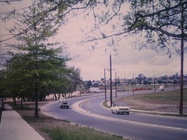
![Photograph - Construction of the F19 [Eastern Freeway], Ron Setford, March 1973](/media/collectors/550653872162f11fb04854aa/items/67fb2e63a8240b7bcaf33ce5/item-media/67fb2e83a8240b7bcaf340a9/item-fit-380x285.jpg) Kew Historical Society Inc
Kew Historical Society IncPhotograph - Construction of the F19 [Eastern Freeway], Ron Setford, March 1973
Ron Setford and his wife Grace Setford lived in Tanner Avenue, East Kew, from c.1946 to c.1995. A keen photographer, he recorded the changing face of Kew over a 20 year period. Apart from 30 photographs of built structures and places in Kew dating from 1960 and 1961, 145 of his 35mm colour slides chronicle the development of the F19 (later renamed Eastern) Freeway through the Yarra Valley in Kew over a five year period from c.1972 to c.1977. This important collection was donated to the Society by his granddaughter in 2025.This collection of 175 35mm slides is of local and statewide significance, owing to its subject matter, particularly the major development of road transport infrastructure during the 1970s with the construction of the Eastern Freeway. The photographer also took care to annotate and date most of his slides which enable the researcher to pinpoint temporal and spatial locations."Eastern Freeway / Start Belford Rd excavation 3/73"ron setford, eastern freeway, f19 freeway