Showing 10391 items
matching plans
-
 Bendigo Historical Society Inc.
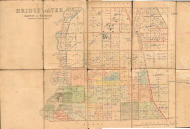
Map - JACK FLYNN COLLECTION: BRIDGEWATER, 6/10/1927
Map: Bridgewater , County of Bendigo. Parish plan.Photo Lithographed at the Department of Lands and Survey, Melbourne by W.J. Butson.map, bendigo, parish plan, bridgewater -
 Bendigo Historical Society Inc.
Map - COLBINABBIN, June 1951
Map: Colbinabbin, County of Rodney. Parish planmap, rodney, parish plan, colbinabbin, county of rodney -
Bendigo Historical Society Inc.
Map - TARNAGULLA SHEET 2, No date Visible
Map: Tarnagulla Sheet 2, Parish planmap, parish plan, tarnagulla -
Bendigo Historical Society Inc.
Map - BENDIGO SHEET 2, Circa 1900
Map: Bendigo sheet 2 . Parish planmap, bendigo, parish plan, bendigo -
Bendigo Historical Society Inc.
Map - SANDHURST,. SHEET ?, 24/04/1907 ?
Map: Sandhurst (sheet No. missing). Parish planmap, bendigo, parish plan, sandhurst -
Bendigo Historical Society Inc.
Map - SANDHURST SHEET 4, 11/03/1925
Map: Sandhurst sheet 4. Parish planmap, bendigo, parish plan, sandhurst -
Bendigo Historical Society Inc.
Map - SANDHURST, SHEET ?, Date missing
Map: Sandhurst (sheet No., Missing) P_arish planmap, bendigo, parish plan, sandhurst -
Bendigo Historical Society Inc.
Map - SANDHURST SHEET 4, No date visible
Map: Sandhurst sheet 4. Parish planmap, bendigo, parish plan, sandhurst -
Bendigo Historical Society Inc.
Map - SANDHURST SHEET 2, 14/03/1923 ?
Map: Sandhurst sheet 2. Parish planmap, bendigo, parish plan, sandhurst -
Bendigo Historical Society Inc.
Map - SANDHURST SHEET 2, Date unreadable
Map: Sandhurst sheet 2. Parish planmap, bendigo, parish plan, sandhurst -
Bendigo Historical Society Inc.
Map - DERBY, 12/05/1892
Map: Derby, County of Bendigo. Paris planmap, bendigo, parish plan, derby -
Bendigo Historical Society Inc.
Map - MANDURANG, 10/11/1909
Map: Mandurang, County of Bendigo. Parish planmap, bendigo, parish plan, mandurang -
Bendigo Historical Society Inc.
Map - NEILBOROUGH, 27/09/1904
Map: Neilborough, County of Bendigo. Parish planmap, bendigo, parish plan, neilborough -
Bendigo Historical Society Inc.
Map - MARONG, Circa 1871
Map; Marong, Hand Draughted parish planmap, bendigo, parish plan, marong -
Bendigo Historical Society Inc.
Map - HUNTLY, Circa 1870's
Map: Huntly, Hand draughted parish planmap, bendigo, parish plan, huntly -
Bendigo Historical Society Inc.
Map - ELMORE, 3/03/1875
Map: Elmore, County of Bendigo. Parish planmap, bendigo, parish plan, elmore -
Bendigo Historical Society Inc.
Map - LOCKWOOD, 13/03/1876
Map: Lockwood, County of bendigo. Parish planmap, bendigo, parish plan, lockwood -
Bendigo Historical Society Inc.
Map - REDCASTLE, 15/10/1878
Map: Redcastle, County of Rodney. Parish planmap, rodney, parish plan, redcastle -
Bendigo Historical Society Inc.
Map - MANDURANG, 10/11/1909
Map: Mandurang, County of Bendigo. Parish planmap, bendigo, parish plan, mandurang -
Bendigo Historical Society Inc.
Map - MANDURANG, Date unreadable
Map: Mandurang, County of Bendigo. Parish planmap, bendigo, parish plan, mandurang -
Bendigo Historical Society Inc.
Map - HUNTLY, 16/11/1903
Map: Huntly, County of Bendigo. Parish planmap, bendigo, parish plan, m -
 Bendigo Historical Society Inc.
Map - SANDHURST SHEET 3, June 29th 1967
Map: Sandhurst sheet 3. Parish plan.map, bendigo, city streets, sandhurst, early bendigo -
 Bendigo Historical Society Inc.
Map - SANDHURST SHEET 2, March 12th 1867
Map: Sandhurst sheet 2 . Parish plan.map, bendigo, city streets, sandhurst, early bendigo -
University of Melbourne, Burnley Campus Archives
Document, Burnley: Celebrating 125 years of Horticultural Education 1891-2016, 2015
Planning notes for activities for 2016. 5 pp.burnley, horticultural education -
University of Melbourne, Burnley Campus Archives
Document, Orchard Development Plan, c. 1983
Plan to redevelop orchard, including greenhouse areaorchard, greenhouse -
Stawell Historical Society Inc
Map, Gold Mines of Australia, Gold Mines of Australia underground workings. Newington Rd Darlington Rd Area 1950, 1950
Plans Showing Surveys & Drilling Stawell InvestmentGold Mines of Australia Stawell Investment 2003 mining, gold, map -
 Whitehorse Historical Society Inc.
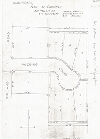
Document, Walter Wicking Plan of Subdivision, ?1952
Plan of subdivision for Wicking CourPlan of subdivision for Wicking Court, South Blackburn.Plan of subdivision for Wicking Courland subdivision, wicking court, blackburn south, wicking, walter benjamin, holland road -
 Whitehorse Historical Society Inc.
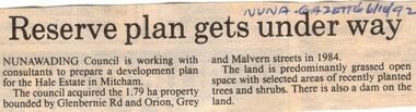
Article, Reserve plan gets under way, 6/10/1992 12:00:00 AM
Article on the development planArticle on the development plan of the Hale Estate, Mitcham.Article on the development planhale estate, mitcham, glenburnie road, orion street, vermont, grey street, malvern street, land subdivision -
Whitehorse Historical Society Inc.
Document, Wandinong Sanctuary Management Plan, 2000?
Wandinong Sanctuary Advisory Committee Management Plan.Wandinong Sanctuary Advisory Committee Management Plan.Wandinong Sanctuary Advisory Committee Management Plan.wandinong sanctuary, wandinong sanctuary advisory committee, ellemor, w r, nechwatal, janine -
Whitehorse Historical Society Inc.
Document, Types of timber-framed dwelling houses, 1920s
Two plans of two bedroom weatherboard houses.Two plans of two bedroom weatherboard houses.Two plans of two bedroom weatherboard houses.californian bungalows, weatherboard