Showing 11734 items matching " ringwood"
-
 Ringwood and District Historical Society
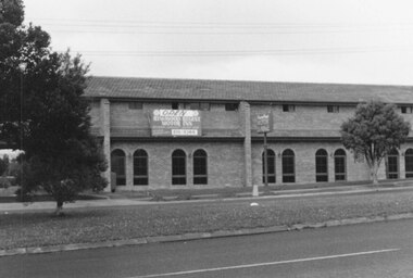
Photograph, Ringwood Motor Inn, Ringwood, 1982
Catalogue card reads, "Ringwood, 1982. Ringwood Motor Inn." -
 Ringwood and District Historical Society
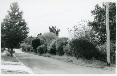
Photographs, Suda and Khassa Ave Ringwood, Before and after Ringwood Bypass Construction 1993
B&W photograph taken by Ringwood Historical Research Group. Also added extract from Melways showing the roads before the Bypass (1987) showing the planned Bypass cutting these two roads, and Melways (2018) showing new alignment with Bypass11063A: 17.1.93 Suda Ave Still intact towards Maroondah Hwy. Taken near Khassa Pde 11063B: 17.1.93 Suda Ave. House gone. Near Khassa Pde 11063C: 17.1.93 Ringwood Bypass from cnr Khassa Pde and Suda Ave towards Mt Dandenong Rd 11063D: 17.2.93 Suda Ave. House gone. 11063E: 21.2.93 cnr Khassa Pde and Suda Ave. Direction of next cut for the Ringwood Bypass. Trees to go. 11063F: 21.2.93 Connection from ??? St to North end of Suda Ave 11063G: 22.2.93 Adelaide St to right (closed). Mile Ave in front and turning left. Note the grey wall along Miles St to support the new car park development. Shrub on left is in the bowling club. -
 Ringwood and District Historical Society
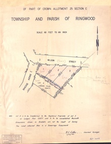
Document - Plan of Subdivision, Part of Crown Allotment 25 Section E, Township and Parish of Ringwood - 1961
Map showing residential allotments numbered 1, 2, 3 and 4, on Wilson Street and Braeside Avenue, Ringwood East, Victoria.Signed and dated 1/12/1961. Rubber stamped Kirkpatrick & Webber, Licensed Surveyors, Civil Engineers & Town Planners, 225 Maroondah Highway, Ringwood, Telephone 870-0321. Ref 3438C. "Note: Lot 4 is to be transferred to the Registered Proprietor of Lot 2 on Lodged Plan 23477 and is to be consolidated therewith." Map also includes handwritten Estate Agent notations. -
 Ringwood and District Historical Society
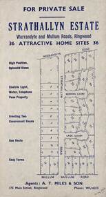
Flyer, Land Sale Advertisement - Strathallyn Estate, Ringwood, Victoria - circa 1950
Advertisement for private sale of 36 home sites in the Warrandyte Road and Mullum Mullum Road area of Ringwood, with map showing layout of subdivision and summary of local features and services. Handwritten notation indicates May, 1950.Subdivision includes Warrandyte Road, Strathallyn Road, Norman Court, Lade Court, and Mullum Mullum Road. Agents: A.T. Miles & Son, 175 Main Street, Ringwood, Phone WU6215. -
 Ringwood and District Historical Society
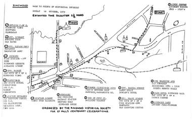
Pamphlet, Ringwood Walk - Points of Historical Interest, 1979
Sketch of walking route for 17 historical points of interest organised by the Ringwood Historical Society for St. Paul's Church Centenary Celebrations - 14 October 1979, estimated duration 2-1/4hours.1 - Start 2 - Cnr Braeside Avenue, old township, brickworks 1881-1916, Guests, Herrys, Hills 3 - Club Hotel, Ringwood Hall, 1st site of C of E church corner 4 - Ringwood Lake, Anthony Ford - pioneer 5 - Opposite Bardia Street, Sandy Gully, Duncan's Hotel 6 - Opposite Pratt Street, 2nd site of C of E, 2nd fire station, Bentleys, old shopping centre 7 - Warrandyte Road, Former Clocktower site, Pratts butcher shop, Bamfords 8 - End of Pitt Street, building viaduct 9 - Bedford Road, Webdales, old crossing, railway station 10 - Station Street, views over railways 11 - Station entrance, old shopping centre, 2nd Postoffice, 2nd blacksmiths, Mechanics Institute, Town Hall 12 - Clocktower, 3rd State School, coolstores, 3rd Postoffice, market, Kenworthys 13 - Opposite market, 3rd site of C of E, Ringwood views 14 - Adelaide Street, Dickens, 1st fire station, Ringwood Reserve 15 - Opposite squash courts, Matlocks, Salvation Army 16 - Opposite library, bowling club, old baths 17 - Outside C of E, Ringwood views, Brittens, Glamorgan -
 Ringwood and District Historical Society
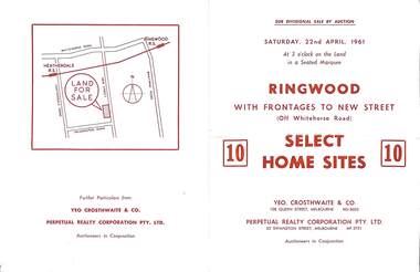
Flyer, Auction sale brochure advertising home sites with frontages to New Street, Ringwood, Victoria - 1961
Advertisement for Sub-divisional sale by auction on Saturday, 22nd April, 1961, with terms of sale of 10 home sites with frontages to New Street, Ringwood, Victoria.Location map showing land for sale on New Street, Ringwood, north of Palmerston Road. Auctioneers in conjunction - Yeo, Crosthwaite & Co., 108 Queen Street Melbourne (Telephone) MU 8605, and Perpetual Realty Corporation Pty. Ltd., 62 Swanston Street, Melbourne (Telephone) MF 3721. -
 Ringwood and District Historical Society
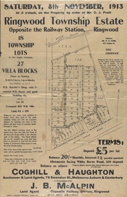
Flyer, Auction Sale Advertisements - Ringwood Township Estate, Ringwood, Victoria - 1913
Advertisements for auction sale of retail and residential blocks opposite the Ringwood Railway Station on Saturday, 8th November, 1913, showing subdivision layout, terms of sale, and summary of local features and services. Auction at 3 o'clock on the property by order of Mr. O.J. Pratt - 18 township lots, 27 villa blocks, also weatherboard butcher's shop with 5-roomed weatherboard house and good stabling, and 5-roomed new weatherboard villa. Subdivision includes Station Road (later Warrandyte Road), Pratt Street, and Whitehorse Road. Agents - Coghill & Haughton, 79 Swanston Street, Melbourne, Auburn & Canterbury, in conjunction with J.B. McAlpin, Opposite Railway Station, Ringwood. Additional 2 partially trimmed copies allotment maps on cardboard backing with handwritten sales notations. -
 Ringwood and District Historical Society
Photograph, Opening of the Ringwood Bowling Green 4th Sept, 1954, Gwen and Robert Horman
Opening of the Ringwood Bowling Green 4th Sept, 1954, Gwen and Robert Horman. All material is from Gwen Horman’s three albums that she owned. Some photos have been taken by Peter Payens of Ringwood Studios, 36 Whitehorse Road, Ringwood, WU-7609, probably for the Ringwood mail newspaper. -
 Ringwood and District Historical Society
Biographies, War histories of two brothers: Leonard Grant Collett and Keith Charles Collett c1950, c. 1950
War histories of two brothers: Leonard Grant Callett and Keith Charles Collett who joined the VX41760 2/23 Battalion. Both were killed within a week of each other. Their mother Cecilia Evelyn Collett lived in Greenwood Avenue, Ringwood.War histories of two brothers: Leonard Grant Collett and Keith Charles Collett who joined the VX41760 2/23 Battalion. Both were killed within a week of each other. Their mother Cecilia Evelyn Collett lived in Greenwood Avenue, Ringwood. +Additional Keywords: Collett, Leonard Grant / Collett, Keith Charles / Collett, Cecilia Evelyn -
 Ringwood and District Historical Society
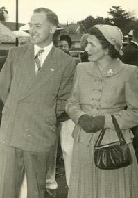
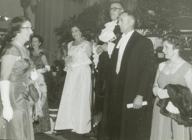
Photograph, Ringwood Proclamation Ball, March, 1960 with Mayor Cr. AG Lavis
Proclamation Ball, March, 1960 – Mayor Cr. AG Lavis (3rd from right), Gwen Horman (far right). In Ringwood Town Hall. On the occasion of the Proclamation of Ringwood as a City. All material is from Gwen Horman’s three albums that she owned. Some photos have been taken by Peter Payens of Ringwood Studios, 36 Whitehorse Road, Ringwood, WU-7609, probably for the Ringwood mail newspaper. -
 Ringwood and District Historical Society
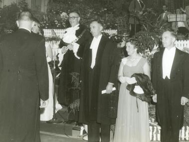
Photograph, Ringwood Proclamation Ball, March 1960 with Mayor Cr. AG Lavis
Proclamation Ball, March, 1960 – Mayor Cr. AG Lavis (4rd from right), Bob and Gwen Horman (far right). In Ringwood Town Hall. On the occasion of the Proclamation of Ringwood as a City. All material is from Gwen Horman’s three albums that she owned. Some photos have been taken by Peter Payens of Ringwood Studios, 36 Whitehorse Road, Ringwood, WU-7609, probably for the Ringwood mail newspaper. -
 Ringwood and District Historical Society
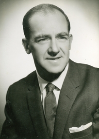
Photograph, Official photo of Cr Bob Horman at Ringwood Proclamation, March 1960
Official photo of Cr Robert "Bob" C Horman at Ringwood Proclamation, March 1960. All material is from Gwen Horman’s three albums that she owned. Some photos have been taken by Peter Payens of Ringwood Studios, 36 Whitehorse Road, Ringwood, WU-7609, probably for the Ringwood mail newspaper. -
 Ringwood and District Historical Society
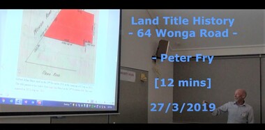
Mixed media - Video, RDHS Guest Speaker Presentation - "Land Title History, 64 Wonga Road, Ringwood" - Peter Fry
Digitised video (662MB). Duration: 12 minutes. Recorded March, 2019. (Video is available for viewing at Ringwood & District Historical Society Archives by appointment)Presentation: Peter Fry has done quite a bit of tracing of properties in the Ringwood area where he grew up. In this talk, Peter presents an example of his research, covering the house and property now known as 64 Wonga Road, which has a long and interesting history dating back to the early days of orcharding in the district. -
 Ringwood and District Historical Society
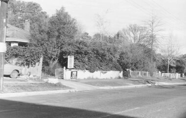
Photograph, No.1 Bond Street, Ringwood - 1981
No.1 Bond Street, Ringwood - 1981.Written on back of photograph, "1981, View of 1 Bond Street (Dr. Matthews?). Where Dalty's are soon to build". -
 Ringwood and District Historical Society
Document, Packet: Ringwood City Council Clippings, News and Booklets 1990s
Ringwood News and booklets c.1990 -
Ringwood and District Historical Society
Envelope, First land sales in Ringwood 1858
First land sales in Ringwood 1858 -
 Ringwood and District Historical Society
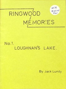
Booklet, Ringwood Memories
Ringwood Memories No 1 Loughnan's Lake -
 Ringwood and District Historical Society
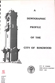
Book, Demographic Profile of the City of Ringwood, 1989
Demographic Profile of the City of Ringwood 1989 -
 Ringwood and District Historical Society
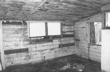
Photograph, Dismantling Ringwood miners cottage in 1975
Dismantling Ringwood miners cottage in 1975 -
 Ringwood and District Historical Society
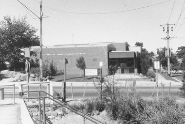
Photograph, Church of Christian Science, Station Street, Ringwood - 1973, 1973
Church of Christian Science, Ringwood in 19734-3-73 Station St. -
 Ringwood and District Historical Society
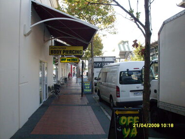
Photograph, Access road in front of Eastland looking east. Showing "Off Ya Tree" and "Punctured Body Piercing" shops. Ringwood on 21 April 2009
Ron Brons photographic study of Ringwood. -
 Ringwood and District Historical Society
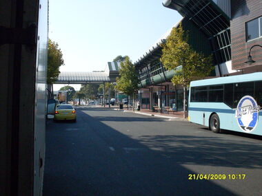
Photograph, Access road in front of Eastland looking east. Showing "Easy Rider" bus. Ringwood on 21 April 2009
Ron Brons photographic study of Ringwood. -
 Ringwood and District Historical Society
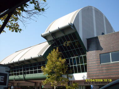
Photograph, Rear view of former Ringwood Library, from Eastland access road, on 21 April 2009
Ron Brons photographic study of Ringwood. -
 Ringwood and District Historical Society
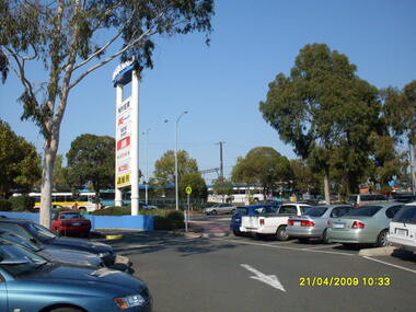
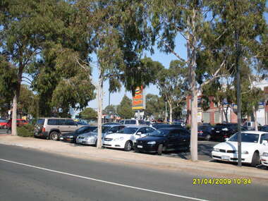
Photograph, Eastland car park looking south, Ringwood on 21 April 2009. Showing former entrance to Adelaide Street from Maroondah Highway, overlooking bus terminus
Ron Brons photographic study of Ringwood -
 Ringwood and District Historical Society
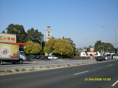
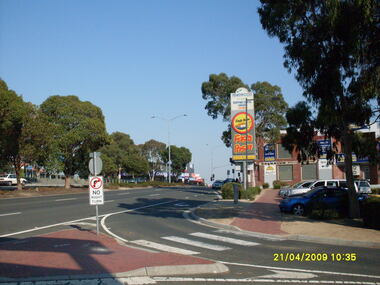
Photograph, Corner of Maroondah Highway and Wantirna Road looking south-west, Ringwood on 21 April 2009. Memorial Clocktower, Haymes Paint and Johnny Boys Pizza
Ron Brons photographic study of Ringwood -
 Ringwood and District Historical Society
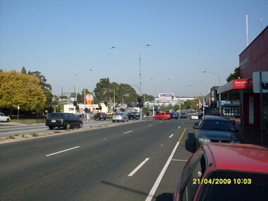
Photograph, Corner of Maroondah Highway and Wantirna Road looking west, Ringwood on 21 April 2009
Ron Brons photographic study of Ringwood -
 Ringwood and District Historical Society
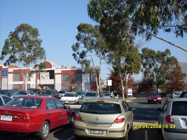
Photograph, Looking across stage 4 Eastland carpark, towards the south-west, on 21 April 2009. Showing strip of shops opposite the Ringwood Station
Ron Brons photographic study of Ringwood. -
 Ringwood and District Historical Society
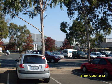
Photograph, Looking across stage 4 Eastland carpark, towards the west, on 21 April 2009. Showing the former Ringwood Library
Ron Brons photographic study of Ringwood. -
 Ringwood and District Historical Society
Photograph, Looking across stage 4 Eastland carpark, towards the south-west, on 21 April 2009. Showing Ringwood Railway Station across Maroondah Highway
Ron Brons photographic study of Ringwood. -
 Ringwood and District Historical Society
Photograph, Looking along Maroondah Highway towards the south-east, on 21 April 2009. Showing entrance to Ringwood Railway Station, Carter Real Estate and Fasta Pasta sign
Ron Brons photographic study of Ringwood.