Showing 2559 items
matching aerial
-
 Stawell Historical Society Inc
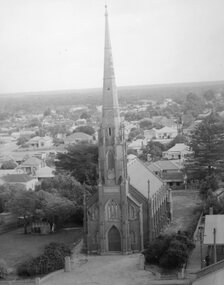
Photograph, St. Matthew’s Presbyterian Church from town hall clock tower c1959-1960
St. Matthew’s Church 1959-1960 taken from town hall clock tower. Photo taken around 1959 -1960. The Centenary book states brick fence and pillars were a gift from McCracken Family, but not in the year the church was built. This photo was used for the Centenary book cover and was taken from the Town Hall clock tower. The roof line in bottom right corner of photo is rear of town hall.Two photographs of St Matthew's Church taken from the Stawell Town Hall. The photo shows an aerial view of the church and houses behind the church. stawell religion -
 Whitehorse Historical Society Inc.
Letter - Correspondence, Mullum Mullum Park, 1/11/2006 12:00:00 AM
Letter from Tony Robinson, MP to RC & BJ Gardiner about the formation of the new Mullum Mullum Park; aerial photo of the area on verso.Letter from Tony Robinson, MP to RC & BJ Gardiner about the formation of the new Mullum Mullum Park; aerial photo of the area on verso.Letter from Tony Robinson, MP to RC & BJ Gardiner about the formation of the new Mullum Mullum Park; aerial photo of the area on verso.mullum mullum park, tony robinson -
 Whitehorse Historical Society Inc.
Photograph - Aerial Photograph, Mitcham Reservoir
Most of the area is now Thornton Crescent, Mitcham, a factory area. When erecting the present 'buildings', which are all single level, certain strategies were employed to ensure safety.Black and white aerial photograph of Mitcham showing the reservoir, Australian Tesselated Tiles with the clay pit at the rear, and Monarch Tiles (1914-16) in the foreground.mitcham reservoir, australian tesselated tile co. pty ltd, monarch terra cotta pty ltd -
 Tennis Australia
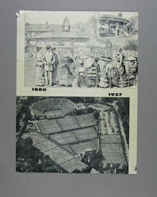
Page from Magazine, 1957
A page featuring two images, an 1880 lithograph, and a 1957 aerial photograph, of the Newport Casino, the first home of the U.S. Open. Materials: Paper, Inktennis -
 Lakes Entrance Historical Society
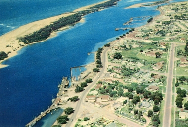
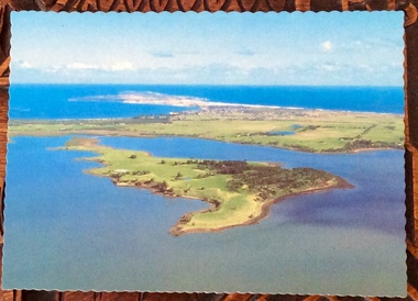
Photograph - Lakes Entrance, 1960c
Copied from postcardColour photograph aerial view of the township, shows also Cunninghame Arm, the hummocks and distant view of Bullock Island and the entrance. Lakes Entrance Victoria hotels, township, waterways -
 Glenelg Shire Council Cultural Collection
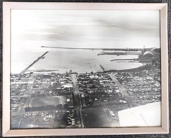
Photograph - Photograph - aerial view of Portland foreshore, 1970s
Aerial view of Portland and foreshore. Black and white photograph. Breakwater is on left, but part has only one domed building evident on far right.Front: (no inscriptions) Back: Twites Picture Framers, Carlton label.portland foreshore, harbour, coastal photography, aerial photo, portland -
Creswick Campus Historical Collection - University of Melbourne
Moving Image, Forests Commission Victoria, Plane Forestry, unknown
This is a film that was used showing how to undertake aerial photography.Film reel -
 City of Ballarat Libraries
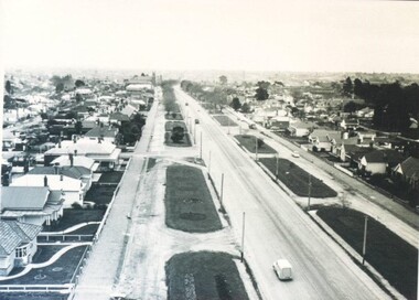
Photograph - Card Box Photographs, Victoria Street, Ballarat circa 1940
Aerial view looking west from Stawell Street.victoria street, ballarat, ballarat east, streetscape, bulding, garden, houses, private dwelling, vehicle, aerial view -
Beechworth Honey Archive
Map- Beechworth
Compiled from 1972 aerial photography. Printed in 1977.Map centred on Beechworth. SHows Beechworth toen, Wooragee, Reids Creek, Woolshed Falls and Lake Kerford. Scale 1:25,000 Printed colour on paper.Map labelled Reids Creek. No. 8225-3-1.map, beechworth, wooragee, reids creek, woolshed falls, lake kerford, aerial photography, paper, beechworth honey -
Beechworth Honey Archive
Map- Eldorado
Compiled from 1971 aerial photography. Printed in 1978.Map shows Eldorado town, Reedy Creek, abandoned gold dredge and Monument Hill. Scale 1:25,000. Printed colour on paper.Map labelled Eldorado. No. 8225-3-4map, eldorado, reedy creek, dredge, monument hill, aerial photography, paper, beechworth honey -
 Heidelberg Golf Club
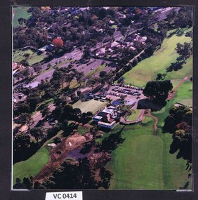
Photograph - Aerial Photograph, Heidelberg Golf Club 1998, 1998
Aerial view of the Heidelberg Golf Club course and buildings.Colour photograph.hgc clubhouse 1998, aerial photographs -
Port Melbourne Historical & Preservation Society
Photograph - Aerial view of J Kitchen & Sons site, Port Melbourne, 21 Mar 1939
Large black and white aerial photo in narrow gold-coloured metal frame of J Kitchen & Sons Pty Ltd factory with Woodruff St in foreground (Electric candles, pure Velvet Soap,and full company name on buildings) "Aerial view looking East. This view shows the two main blocks . 21/3/39" - printed below photo (copy of original)industry - manufacturing, built environment - industrial, j kitchen & sons pty ltd, pental products pty ltd, symex holdings ltd -
 St Kilda Historical Society
Photograph, 11 Eildon Road, St Kilda, 1990-2000?
oringinal colour photograph, TV aerial, cars parked in roadcolour photograph, unmounted good condition11 Eildon Road -
 City of Ballarat Libraries
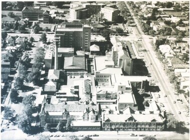
Photograph - Card Box Photographs, Ballarat Base & St John of God Hospitals, Ballarat circa 1960
Aerial views of the Ballarat Base and St John of God Hospitals.ballarat base hospital, st john of god hospital, ballarat, drummond street noth, building, aerial view -
 Bendigo Military Museum
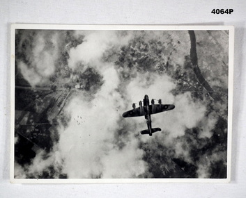
Photograph, c.WWII
Photograph of a Lancaster bomber on a bombing mission. Bombs released by the aircraft are visible. Part of Frederick Gardner Davey DFC No.410533 RAAF collection. See Cat. No. 3536P for his service record.Photo, black & white, white border, aerial photograph of an aircraft dropping a stick of bombs over a target. Ground target partially visible through clouds.On back, handwritten in blue ink: "I.M. Davey Pres. C.W.A. Strathdale. 'Stick of bombs going down'".bombing run, photography, ww2 -
 Phillip Island and District Historical Society Inc.
Photographs, Victoria Conservation Trust, Churchill Island, 1980s
3 coloured postcards and 8 coloured photographs of scenes on Churchill Island including an aerial view, homestead, outbuildings, vegetation, views, cairn and coastal scenes.Postcards say Churchill Island, Victoria. Victoria Conservation Trustchurchill island, churchill island heritage farm, churchill island - homestead, samuel amess -
Phillip Island and District Historical Society Inc.
Photograph
Photograph from The Herald and donated by Jack MorrisonBlack & White Aerial Photograph showing the two bridges between Newhaven and San Remo, the old and the new. (Same photo as 100-09, reduced in size)local history, photography, photographs, slides, film civil engineering, bridges, history of the phillip island bridge, black & white photograph, phillip island bridges -
Glenelg Shire Council Cultural Collection
Photograph - Photograph - Aerial view of Battery Point and silos, 05/03/1971
Port of Portland Authority archivesFront: (no inscriptions) Back: (no inscriptions)port of portland archives -
Glenelg Shire Council Cultural Collection
Souvenir - 'Back to Portland' souvenir program, E. Davis and Sons Pty Ltd, Portland, Vic, Back to Portland 1981, 1981
1981 'Back to' Portland souvenir program. 12 pages, cardboard cover, white; image of the landing of the Hentys at Portland. Back cover - aerial photo of the port.portland, 1981, 1980s -
Glenelg Shire Council Cultural Collection
Photograph - Photograph - Aerial Photo railway line between Heywood and Rennick, 03/05/1952
Victorian Railways aerial survey record print of the railway line between Heywood and Rennick (S.A. border) Black and white, white vertical strip on imageFront: Annotations in black and blue ink, added at a later date Back: 'Heywood - Rennick 21222 - 19503 248m 16c Heywood' - all black ink.. White sticker with 'LYONS' printed on it. '3 May 1952' - black stamp -
Glenelg Shire Council Cultural Collection
Card - Christmas Card, n.d
Christmas card from the Port of Portland Authority to K.S. Anderson. Cream card, gold print, aerial photograph of the Port of Portland on front cover. Unsigned.greetings card, christmas, k s anderson, port of portland authority archives -
Glenelg Shire Council Cultural Collection
Photograph - Photograph - Thomas Borthwick and Sons, n.d
Port of Portland Authority Archivesport of portland -
Glenelg Shire Council Cultural Collection
Photograph - Photograph - Portland Harbour, n.d
Port of Portland Authority Archivesport of portland archives, portland harbour -
Glenelg Shire Council Cultural Collection
Functional object - Fishing Rod, n.d
Post World War 2 fishing rod, mde from metal armoured tank aerial, with wooden handle and fitted with an 'Alvy' brand bakelite reel -
Glenelg Shire Council Cultural Collection
Photograph - Photograph - Aerial photograph of coastline around Portland Victoria, c. 1954
Black and white aerial photograph of coastline around Portland. Black border, bottom edge, section of larger photo, approximately 50%, only land visible.Front: 'PORTLA' -printed, white border -
 Ringwood and District Historical Society
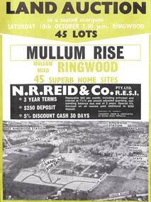
Flyer, Land Auction Advertisement, Mullum Rise, Ringwood - 1970
Double sided leaflet with aerial view of part of Ringwood showing subdivision site, terms of sale, layout of streets and allotments, and summary of local features and services.Land auction, Saturday, 10th October (1970). 45 home sites. Subdivision includes Mullum Mullum Road, Hugh Street, Rollington Drive, Cassandra Court, and Jeffrey Drive. Surveyors - R.G. Lee Pty. Ltd., 6 Davis Street, Richmond. Agents - N.R. Reid & Co., 173 Coleman Parade, Glen Waverley, (Telephone) 560 0355 A.H. 560 0361 and Safeway Centre, Boronia Road, Boronia, (Telephone) 762 1022 A.G. 795 2887, also at East Malvern and Mount Waverley. -
Glenelg Shire Council Cultural Collection
Photograph - Photograph - Aerial black and white photograph of Portland harbour and foreshore taken from the N.E. Cape Nelson in background, 07/07/1968
Port of Portland Authority archivesFront: (no inscriptions) Back: 'Port area with Cape Nelson in background 7/7/1968 (at 800 feet) Harbour basin with 600ft entrance between breakwaters.port of portland archives, cape nelson, no6 berth construction, ocean pier -
Glenelg Shire Council Cultural Collection
Photograph - Photograph - Aerial black and white photograph of Portland Harbour and foreshore taken from the N.E. Cape Nelson in background, 07/07/1968
Port of Portland Authority archivesFront: (no inscriptions) Back: 'Port area with Cape Nelson in background 7/7/1968 (at 800 feet) Harbour basin with 600ft entrance between breakwaters.port of portland archives, cape nelson -
Glenelg Shire Council Cultural Collection
Photograph - Photograph - Aerial view from NE Portland Harbour, c. 1967
Port of Portland Authority ArchivesFront: 19 JUN 1997 Back: 19 JUN 1997port of portland archives, ocean railway pier, portland harbour -
Glenelg Shire Council Cultural Collection
Photograph - Photograph - aerial view of Portland Hanrbour, n.d
Port of Portland AuthorityBack: Reduce to 52cms wide and 30cms deep - pencil ruled pencil border.port of portland archives, aerial photography, portland harbour