Showing 2091 items
matching bendigo maps
-
 Bendigo Historical Society Inc.
Map - RUNNYMEDE : COUNTY OF BENDIGO, 8-12-13
... Map. County of Bendigo, County of Rodney, Burnewang, Elmore... Inc. History House 11 Mackenzie Street Bendigo goldfields MAP ...Map. County of Bendigo, County of Rodney, Burnewang, Elmore, Nolan, Campaspe, Colbinabbin, Burramboot, Corop, Township of Runnymede, Campaspe River, Mount Pleasant Creek. Photo-Lithographed at the Department of Lands and Survey, Melbourne by W.J. Butson.8-12-13. Price 1/-. (number 107 in map cupboard 1)W.J. Butsonmap, bendigo, runnymede -
Bendigo Historical Society Inc.
Map - TOOLLEEN : COUNTY OF BENDIGO, 25-5-26
... Map. Toolleen, County of Bendigo, County of Rodney... Inc. History House 11 Mackenzie Street Bendigo goldfields MAP ...Map. Toolleen, County of Bendigo, County of Rodney, Campaspe, Colbinabbin, Cornella, Crosbie, Muskerry, Mount Pleasant Creek, Township of Toolleen. By authority H.J. Green, Govt. Printer. Photo-Lithographed at the Department of Lands and Survey, Melbourne by W.J. Butson, 25-5-26. (number 106 in map cupboard 1)H.J. Green, Govt. Printermap, bendigo, toolleen -
Bendigo Historical Society Inc.
Map - TOOLLEEN : COUNTY OF BENDIGO, 25-5-26
... Map. Toolleen, County of Bendigo, County of Rodney... Inc. History House 11 Mackenzie Street Bendigo goldfields MAP ...Map. Toolleen, County of Bendigo, County of Rodney, Campaspe, Colbinabbin, Cornella, Crosbie, Muskerry, Mount Pleasant Creek, Township of Toolleen. By authority H.J. Green, Govt. Printer. Photo-Lithographed at the Department of Lands and Survey, Melbourne by W.J. Butson, 25-5-26. (number 105 in map cupboard 1)H.J. Green, Govt. Printer.map, bendigo, toolleen -
Bendigo Historical Society Inc.
Map - KNOWSLEY EAST : COUNTY OF BENDIGO, 18-112-77
... Inc. History House 11 Mackenzie Street Bendigo goldfields MAP ...Map. Knowsley East, County of Bendigo, County of Rodney, Weston, Knowsley, Crosbie, Dargile, Heathcote, Forest Creek, Shingle Hut Creek, Mt. Camel Estate, Sheep Station Creek, Mount Ida Creek. Photo-graphed at the Department of Lands and Survey, Melbourne by J. Noune 18-12-77, (number 104 in map cupboard 1)J. Nounemap, bendigo, knowsley east -
Bendigo Historical Society Inc.
Map - KNOWSLEY : COUNTY OF BENDIGO, 7-11-1941
... Map. Knowsley, County of Bendigo, County of Rodney, Weston... Inc. History House 11 Mackenzie Street Bendigo goldfields MAP ...Map. Knowsley, County of Bendigo, County of Rodney, Weston, Axedale, Eppalock, Knowsley East, Langwornor, Heathcote, Campaspe River, Mt. Ida Creek or Wild Duck Creek, Sandhurst and Heathcote Railway, Kilmore-Heathcote-Bendigo Road. Knowsley Station Ground. Shingle Hut Creek, Forest Creek. By authority H.E. Daw, Government Printer, Melbourne. Drawn and reproduced at the Department of Lands and Survey, Melbourne. 7-11-1941. Price 2/-. (number 103 in map cupboard 1)H.E. Daw, Government Printer, Melbourne.map, bendigo, knowsley -
Bendigo Historical Society Inc.
Map - KNOWSLEY : COUNTY OF BENDIGO, 21-1-19
... Map. Knowsley, County of Bendigo, County of Rodney, Weston... Inc. History House 11 Mackenzie Street Bendigo goldfields MAP ...Map. Knowsley, County of Bendigo, County of Rodney, Weston, Crosbie, Knowsley, Dargile, Heathcote, Shingle Hut Creek, Sheep Station Creek, Forest Creek, Bendigo and Wallan Railway, Mt. Ida Creek. By authority A.J. Mullett, Government Printer, Melbourne. Photo-Lithographed at the Department of Lands and Survey, Melbourne by W.J. Butson 21-1-19, Price 1/-. (number 102 in map cupboard 1)A.J. Mullett, Government Printer, Melbourne.map, bendigo, knowsley east -
Bendigo Historical Society Inc.
Map - HARCOURT : COUNTY OF BENDIGO, 23-3-10
... Map. County of Bendigo, County of Talbot, Sutton Grange... Inc. History House 11 Mackenzie Street Bendigo goldfields MAP ...Map. County of Bendigo, County of Talbot, Sutton Grange, Ravenswood, Walmer, Faraday, Castlemaine, Axe Creek, Barkers Creek, Melbourne to Echuca Railway, Victorian Water Supply in Connection with Barkers Creek Reservoir. Victorian Water Supply Reserve, Mt. Alexander State Forest. Three areas reserved for Sericulture (Silkworms). Photo-Lithographed at the Dept. of Lands and Survey, Melbourne by T.F. McGauran 23-3-10. Price 1/-. (number 101 in map cupboard 1)T.F. McGauranmap, bendigo, harcourt -
Bendigo Historical Society Inc.
Map - HARCOURT : COUNTY OF BENDIGO, December 1951
... Map. Harcourt, County of Bendigo, County of Talbot, Town... Inc. History House 11 Mackenzie Street Bendigo goldfields MAP ...Map. Harcourt, County of Bendigo, County of Talbot, Town of Harcourt, Walmer, Sutton Grange, Ravenswood, Victorian Water Supply Reservoir, in connection with Barkers Creek Reservoir, Barkers Creek, Calder Highway, Northern Railway, Axe Creek. By authority J.J. Gourley, Government Printer, Melbourne. Drawn and reproduced at the Department of Lands and Survey, Melbourne. December 1951. Price 5/- per sheet. (number 100 in map cupboard 1)J.J. Gourley, Government Printer, Melbourne.map, bendigo, harcourt -
 Bendigo Historical Society Inc.
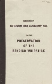
Book - 'PRESERVATION OF THE BENDIGO WHIPSTICK'' (SUBMISSION)
... Naturalists Club. Shire of Lodden Map. Bendigo Field Naturalist Club ...Preservation of the Bendigo Whipstick'' (Third Edition of a Submission by the Bendigo Field Naturalists' Club 1971). An application to the Forests Commission for two areas to be declared Forest Parks under the Appropriate Act. (The two areas are indicated on a map submitted under separate cover). Supportive material includes listings of various categories e.g. flora i.e Whipstick native plants; Additional Plant Species; Species of Birds; Mammals of the Whipstick; historical summary; Whipstick nuggets; Bendigo Whipstick 'Statistics'. .Bendigo Field Naturalist Club.government, state, whipstick, bendigo whipstick, the bendigo field naturalists club. shire of lodden map. -
Bendigo Historical Society Inc.
Map - HAWKESTONE : COUNTY OF BENDIGO, December 1953
... Inc. History House 11 Mackenzie Street Bendigo goldfields MAP ...Map. Hawkestone, Parish, County of Bendigo, County of Talbot, Sutton Grange, Redesdale, Faraday, Elphinstone, Metcalfe, Lyell, Coliban River, Myrtla Creek. By Authority W.M. Houston, Government Printer. Drawn and reproduced at the Department of Lands and Survey, Melbourne. December 1953. Price 2/-. (number 99 in map cupboard 1)W.M. Houston, Government Printer.map, bendigo, hawkestone. -
Bendigo Historical Society Inc.
Map - HAWKESTONE, COUNTY OF BENDIGO, December 1953
... Map, Hawkestone, County of Bendigo, County of Talbot... Inc. History House 11 Mackenzie Street Bendigo goldfields MAP ...Map, Hawkestone, County of Bendigo, County of Talbot, Sutton Grange, Redesdale, Lyell, Myrtle Creek, By authority W.M.Houston, Government Printer. Drawn and Reproduced at the Dept. of Lands and Survey, Melbourne, Victoria.December 1953. Price 5/-. (number 98 in map cupboard 1)W.M.Houston, Governmemt Printer.map, bendigo, hawkestone. -
Bendigo Historical Society Inc.
Map - HAWKESTONE : COUNTY OF BENDIGO, December 1953
... Map. Hawkestone, County of Bendigo, County of Talbot... Inc. History House 11 Mackenzie Street Bendigo goldfields MAP ...Map. Hawkestone, County of Bendigo, County of Talbot, Sutton Grange, Redesdale, Faraday, Elphinstone, Metcalfe, Coliban River. By authority W.M. Houston, Government Printer. Drawn and reproduced at the Department of Lands and Survey, Melbourne. December 1953. Price 5/-. (number 97 in map cupboard 1)W.M. Houston, Government Printer.map, bendigo, hawkestone. -
Bendigo Historical Society Inc.
Map - HARCOURT : COUNTY OF BENDIGO, December 1951
... Map. Harcourt, County of Bendigo, County of Talbot... Inc. History House 11 Mackenzie Street Bendigo goldfields MAP ...Map. Harcourt, County of Bendigo, County of Talbot, Ravenswood. Sutton Grange, Walmer, Castlemaine, Faraday, Calder Highway, Northern Railway, Town of Harcourt, Barkers Creek, Victorian Water Supply Res., in connection with Barkers Creek Reservoir. By authority J.J. Gourley, Government Printer, Melbourne .Drawn and reproduced at the Department of Lands and Survey, Melbourne. December 1951. Price 2/- per sheet. (number 96 in map cupboard 1)J.J. Gourley, Government Printer, Melbourne.map, bendigo, harcourt -
Bendigo Historical Society Inc.
Map - HARCOURT, December 1951
... Inc. History House 11 Mackenzie Street Bendigo goldfields MAP ...Harcourt, County of Bendigo, Walmer, Castlemaine, Sutton Grange. Mt.Alexander Trig. Station, Barkers Creek, Faraday, Calder Highway, Northern Railway. By Authority J.J.Gourley, Government Printer, Melbourne,Drawn and Reproduced at the Dept. of Lands and Survey, Melbourne, Victoria. December 1951. Price 5/-per sheet. (number 35 in map cupboard 1)J.J.Gourley, Government Printer, Melbourne.map, bendigo, harcourt -
Bendigo Historical Society Inc.
Map - SALISBURY WEST : COUNTY OF BENDIGO, 3-3-1944
... Map. Salisbury, County of Bendigo, County of Gladstone... Inc. History House 11 Mackenzie Street Bendigo goldfields MAP ...Map. Salisbury, County of Bendigo, County of Gladstone, Powlett, Yarrayne, Bridgewater, Inglewood, River Loddon, Bullabul Creek, Glenalbyn, Kurting. By Authority H.E. Daw, Government Printer, Melbourne. Drawn and reproduced at the Department of Lands and Survey, Melbourne., 3-3-1944. Price 5/-. (number 94 in map cupboard 1)H.E. Daw, Government Printer, Melbourne.map, bendigo, salisbury west -
Bendigo Historical Society Inc.
Map - COSTERFIELD : COUNTY OF BENDIGO, 31-10-12
... Map. Costerfield, County of Bendigo, County of Dalhousie... Inc. History House 11 Mackenzie Street Bendigo goldfields MAP ...Map. Costerfield, County of Bendigo, County of Dalhousie, Dargile, Moorambool West, Warrowitue, Heathcote, Town of Costerfield. Photo-Lithographed at the Department of Lands and Survey, Melbourne, by W.J .Butson 31-10-12 price 1/-. (number 93 in map cupboard 1)W.J. Butsonmap, bendigo, costerfield -
Bendigo Historical Society Inc.
Map - COSTERFIELD : COUNTY OF BENDIGO, 29-10-29
... Map. Costerfield, County of Bendigo, Counties of Dalhousie... Inc. History House 11 Mackenzie Street Bendigo goldfields MAP ...Map. Costerfield, County of Bendigo, Counties of Dalhousie & Rodney, Dargile, Moormbool West, Warrowitue, Heathcote, Town of Costerfield, Dalhousie. By Authority H.J. Green, Government Printer, Melbourne. Drawn and reproduced at the Department of Lands and Survey, Melbourne. 29-10-29. Price 2/-. (number 92 in map cupboard 1)H.J. Green, Government Printer, Melbourne.map, bendigo, costerfield -
Bendigo Historical Society Inc.
Map - HEATHCOTE : COUNTY OF BENDIGO
... Map. Heathcote, County of Bendigo, County of Dalhousie... Inc. History House 11 Mackenzie Street Bendigo goldfields MAP ...Map. Heathcote, County of Bendigo, County of Dalhousie, Knowsley, Knowsley East, Dargile, Costerfield, Warrowitue, Tooborac, Langwornor, Argyle Station Ground, Bendigo to Heathcote to Kilmore Railway Line, Township of Heathcote, C.R.B. Main Road. Mount Ida Creek, Wild Duck Creek, Meadow Valley Creek. By Authority H.J. Green, Govt. Printer, Photo-Lithographed at the Department of Lands and Survey, Melbourne by W.J. Butson, Price 1/-. (number 91 in map cupboard 1)H.J. Green Govt. Printer.map, bendigo, heathcote -
Bendigo Historical Society Inc.
Map - FRED COWIE COLLECTION: AERIAL MAPS OF HEATHCOTE/EPPALOCK, 28-9-60
... Inc. History House 11 Mackenzie Street Bendigo goldfields MAP ...Map, Heathcote C3, Aerial Survey of Victoria, Photo-map prepared by Department of Crown Lands and Survey from photographs taken in 1960.Copied photographically at the Central Plan Office. Date 28-9 60, C.P.O.Neg. No.21588.Campaspe River, Coliban River. Flower Hill. Fred Cowie,46 McIvor Rd.Bendigo (Not located 29.9.2022)Central Plan Office.map -
Bendigo Historical Society Inc.
Map - FRED COWIE COLLECTION: AERIAL MAPS OF HEATHCOTE/EPPALOCK
... Inc. History House 11 Mackenzie Street Bendigo goldfields MAP ...Map, Heathcote A3, Aerial Survey of Victoria, Photo-map prepared by Department of Crown Lands.Campaspe River , Wild Duck Creek, Knowsley, Eppalock Weir.Fred Cowie,46 McIvor Rd ,Bendigo.map -
Bendigo Historical Society Inc.
Map - FRED COWIE COLLECTION: AERIAL MAPS OF HEATHCOTE/EPPALOCK, 28-9-1960
... Inc. History House 11 Mackenzie Street Bendigo goldfields MAP ...Map, Heathcote C2, Township of Heathcote, Melbourne Road through town branching off to Bendigo & Echuca. Aerial Survey of Victoria. Photo-map prepared by Department of Crown Lands and Survey from photographs taken in 1960. Copied photographically at the Central Plan Office.Fred Cowie,46 McIvor Rd,Bgo..Central Plan Officemap -
Bendigo Historical Society Inc.
Map - FRED COWIE COLLECTION: AERIAL MAPS OF HEATHCOTE/EPPALOCK, 28-9-60
... Inc. History House 11 Mackenzie Street Bendigo goldfields MAP ...Map, Heathcote C4, Aerial Survey of Victoria,Photo-map prepared by Department of Crown Lands and Survey from photographs taken in 1960. Copied photographically at the Central Plan Office.Date 28-9-60,C.P.O.Neg.No.21590.Scale 4 inches to 1 mile. Fred Cowie,46 McIvor Rd,Bgo..Central Plan Office.map -
 Bendigo Historical Society Inc.
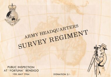
Document - ARMY HEADQUARTERS SURVEY REGIMENT, BENDIGO, 10 May, 1964
Army Headquarters Survey Regiment, Bendigo. Public Inspection at 'Fortuna', 10 May 1964. Donation 2/-. Includes photos of the Entrance Hall, Music Room and Villa. 3 army photos. In 1942 the mansion was occupied by the Australian Survey Corps and 'Fortuna' became the site of the base map production plant of the Australian Army for the remainder of the war years. During this period approximately sixteen million maps of Australian Territories and theatres of operation in the South West Pacific Area, were produced for use by the Allied Services. This function was continued as a peace time role in the post war years, and in 1951 ''Fortuna'' was purchased by the Commonwealth Government. As the largest unit of the Royal Australian Survey Corps, AHQ Survey Regiment carries out mapping in all parts of the Commonwealth and Territories including Papua and New Guinea. The Regiment is not only capable of doing its own field surveys but is responsible for the drawing and printing of map compilations from Royal Australian Survey Corps units in all States. . . . Includes map of grounds.buildings, residential, fortuna villa, army headquarters survey regiment, bendigo. public inspection at 'fortuna', 1964. photos of the entrance hall, music room and villa. mansion was occupied by australian survey corps and 'fortuna' site of the base map production plant australian army war. sixteen million maps australian territories and theatres of operation in the south west pacific area, were produced for use by the allied services. 1951 ''fortuna'' was purchased by the commonwealth government. royal australian survey corps, ahq survey regiment mapping commonwealth and territories including papua and new guinea. royal australian survey corps units in all states. map of grounds -
 Bendigo Historical Society Inc.
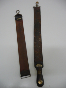
Accessory - RAZOR STROPS
Container (round flat box) of pink-coloured ('Peche') 'Cashmere Bouquet' Face Powder . Top of box ha Two razor strops. 'Gem' brand with attached metal clasp (opening clip); 'Malwa' brand with fixed clip; loose opening clip (from Malwa strop?). Shaped leather handle (detached) with the following in gold embossing - 'Specially Prepared'; '16' with surrounding wreath; map of Australia (with wreath). s product name and flower motif; back of box has manufacturer's details (Colgate Palmolive; Made in Australia etc.personal effects, shaving, razor strop -
 Bendigo Historical Society Inc.
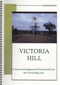
Book - VICTORIA HILL, A HISTORICAL BACKGROUND OF VICTORIA HILL AND THE SURROUNDING AREA, 2011
Victoria Hill a historical background of Victoria Hill and the surrounding area. Original article by Albert Richardson 1971 and revised and edited in 2012 by Philip Wilkin. Contains 26 pages with colour and black & white photographs and a map. Inside front cover is a 'Bendigo Miner' History Lives article by Jim Evans, dated 10 May 2012.Albert Richardson & Phillip Wilkinbendigo, mining, victoria hill -
 Bendigo Historical Society Inc.
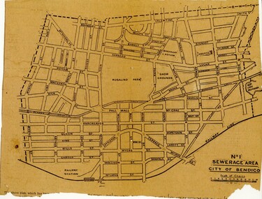
Newspaper - BENDIGO SEWARAGE AREA NEWSPAPER CUTTING, 1921
Newspaper cutting showing map of the No 1 Sewerage Area City of Bendigo. 1921bendigo, planning, sewerage, bendigo sewerage -
Bendigo Historical Society Inc.
Map - YARRAYNE : COUNTY OF BENDIGO, 6-1-32
... Map. Yarrayne, County of Bendigo, Janiember East; Pompapiel... Inc. History House 11 Mackenzie Street Bendigo goldfields MAP ...Map. Yarrayne, County of Bendigo, Janiember East; Pompapiel, Salisbury, Bridgewater, Salisbury West, Powlett. Photo-Lithographed at the Department of Lands and Survey, Melbourne. Price 2/-. 6-1-32. (number 12 in map cupboard 1)H.J. Green, Government Printermap, bendigo, yarrayne -
Bendigo Historical Society Inc.
Map - YALLOOK : COUNTY OF BENDIGO, 1957
... Map. Yallook, County of Bendigo,Talambe, Tandarra... Inc. History House 11 Mackenzie Street Bendigo goldfields MAP ...Map. Yallook, County of Bendigo,Talambe, Tandarra, Neilborough, Yarraberb, Salisbury, Pompapiel. Drawn and reproduced at the Department of Lands and Survey, Melbourne.1957. Price 2/-. By authority W.M. Houston, Government Printer. (number 11 in map cupboard 1)W.M Houston, Government Printermap, bendigo, yallook -
Bendigo Historical Society Inc.
Map - WARRAGAMBA : COUNTY OF BENDIGO, 29-4-30
... Map. Warragamba, County of Bendigo, Pannoomilloo, Kamarooka... Inc. History House 11 Mackenzie Street Bendigo goldfields MAP ...Map. Warragamba, County of Bendigo, Pannoomilloo, Kamarooka, Minto, Diggorra. By authority H.J. Green, Government Printer. Piccaninny Creek. Drawn and reproduced at the Deparment of Lands and Survey, Melbourne. 29-3-30. Price2/-. (number 10 in map cupboard 1)H.J. Green, Government Printermap, bendigo, warragamba -
Bendigo Historical Society Inc.
Map - WANURP : COUNTY OF BENDIGO, 1-12-33
... Map. Wanurp, County of Bendigo, Terrick Terrick East... Inc. History House 11 Mackenzie Street Bendigo goldfields MAP ...Map. Wanurp, County of Bendigo, Terrick Terrick East, Mitiamo, Milloo, Pannoobamawm. By authority H.J. Green, Government Printer.Photo-Lithographed at the Department of Lands and Survey, Melbourne. Price 2/-. 1-12-33. (number 9 in map cupboard 1)H.J. Green, Government Printermap, bendigo, wanurp