Showing 8162 items
matching blocked
-
 Warrnambool and District Historical Society Inc.
Tools, Miner's Pick, Early 20th century
This miner’s pick was of the type used to extract limestone at the Warrnambool limestone quarries, mainly for buildings and walls. This pick cut the sides and the top of the block and then it was levered off with a crowbar at an angle of about 30° to 40°. These blocks were then reduced to the required size using cross cut saws. There were about 12 limestone quarries operating in Warrnambool in the 19th century and limestone was extensively quarried for about 85 years to the 1930s when quarrying ceased. Today there has been a small revival in the Warrnambool area in the use of limestone blocks for building. Warrnambool also once had several bluestone quarries on the outskirts of the town. This miner’s pick has a wooden handle with rounded sides tapering to a wider end. The wood is weather-worn and split in places, especially at the top end. The pick is metal with a curved shape that tapers to a point at one end. The metal near the other end has a cavity into which is inserted the wider end of the wooden handle. limestone quarries in warrnambool, quarrying in warrnambool, warrnambool history -
 Bendigo Military Museum
Administrative record - Report on Jerie Vertical Block Adjustment of the Townsville 1:250,000, AHQ Survey Regiment, 31 Oct 1963
Report describing the "Jerie" Vertical Block Adjustment for the Townsville 1:250,000 and how the apparatus was designed, constructed and used.Foolscap size, 14 x numbered pages and 10 x unnumbered pages. Stapled left side. Numbered pages printed in purple. Four of the unnumbered pages contain photos while the rest contain handwritten tables and hand drawn diagrams. Annex A: Discrepancies Tables, Annex B: Baseboard Diagram, Annex C to Annex G, Annex H: Photo showing tools which are numbered and listed below each photo. The numbers on each photo are faint but readable. royal australian survey corps, rasvy, fortuna, army survey regiment, army svy regt, asr -
 Greensborough Historical Society
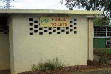
Photograph - Digital image, Marilyn Smith, Watsonia Road toilet block, 2016, 24/05/2016
Watsonia Road shopping strip, toilet block, Watsonia 2016. The shopping strip is managed by the Watsonia Traders Association.Digital copy of colour photograph.watsonia, watsonia road -
 Greensborough Historical Society
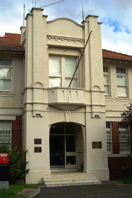
Photograph - Digital image, Marilyn Smith, Mont Park: Central Block Reception, 30/07/2017
Mont Park: Central Block Reception. One of a collection of photographs of the original buildings at the Mont Park Hospital site.Digital copy of colour photographmont park hospital -
![Photograph - Digital image, Marilyn Smith, Mont Park: Central Block [exterior], 30/07/2017](/media/collectors/4f729f5697f83e03086015b8/items/5a0ff07d21ea67165ce92f9b/item-media/5a0ff0bd21ea67165ce94ef4/item-fit-380x285.jpg) Greensborough Historical Society
Greensborough Historical SocietyPhotograph - Digital image, Marilyn Smith, Mont Park: Central Block [exterior], 30/07/2017
Mont Park: Central Block - exterior. Part of a collection of photographs of the original buildings at the Mont Park Hospital site. Digital copy of 3 colour photographsmont park hospital -
 Victoria Police Museum
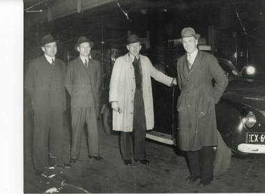
Photograph (police car), Kodak
Photo shows bumper bars painted white when the headlights were half blocked during the "brown out".A Mercury Wireless Patrol car and crew in 1944. Left to right: J O'Connor 9186. G Cracknell 9395 (driver). W Crowley 9315, A Coventry 9320.police vehicles; transport branch; wireless patrol; motor police branch; motor traffic section; ford mercury car -
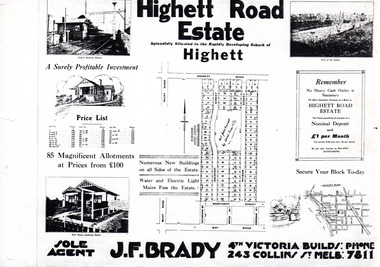 City of Moorabbin Historical Society (Operating the Box Cottage Museum)
Flyer - Highett Road Estate, Highett
With the growth of Melbourne the market gardens were subdivided into building blocks as the land was worth more than the value of the crops.Example of the progress of the Municipality of MoorabbinPhotocopy of advertisement of private sale of housing lots in Highett.Highett Road Estate, Highett - 85 Magnificent Allotmentshighett road, wilson st, dalmont street, highett, real estate -
 Tatura Irrigation & Wartime Camps Museum
Sandals - female, 1940's
Used by internees at Camp 3. Known as "Klip Klop" sandals, worn to lavatory and shower blocks early morningsPair of carved wooden platform heel sandals. Synthetic covering on heel and sole. Leather strap nailed in position to cover toessandals, wood, bissinger g, wied k and n, camp 3, tatura, ww2, costume, female, foorwear, handcrafts, woodwork -
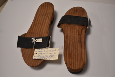 Tatura Irrigation & Wartime Camps Museum
Sandals - female, 1940's
Used by internees at Camp 3. Known as "Klip Klop" sandals. Worn to lavatory and shower blocks early mornings.Pair of carved wooden platform heel sandals. Rubber like covering on heel and sole. Leather strap nailed in position to cover toessandals, bissinger g, wied k and n, camp 3, tatura, ww2, costume, female, footwear, handcrafts, woodwork -
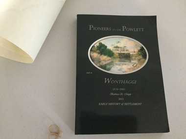 Wonthaggi & District Historical Society
Book and Map, Barbara Moyle, Pioneers on tthe Powlett and at Wonthaggi 1878-1910, 2015
Book - families social histories, maps, photograps Map - block numbers town names physical / geographical featuresFarming and social history of pioneers of the Powlett River are prior to the establishment of the State Coal Mine at Wonthaggi. Significant land marks, buildings and photographs are included. Dark green cover with oval artists impression of Powlett river and bridge Associated map which covers the parishes plus key places of interestlPioneers on the Powlett and at Wonthaggi 1878-1910 Barbara R Moyle 2015 Early History of Settlement Map - Parish names, significant sitesfarming, pioneers of wonthaggi and district, wonthaggi families -
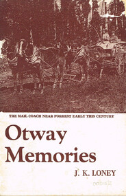 Otway Districts Historical Society
Book, J.K. Loney, Otway memories. J.K. Loney, 1971
A family history of the Thomas James McMinn family and the settlement on Block 33 on the Wait-a-while Road, Wyelangta, Victoria.Otway memories. J.K. Loney. Soft cover. i, 53 p.; illus, map. 1971the beechy; roads; forests; sawmills; bushfires; history; visitors' guide; reminiscences; wyelangta; -
 Phillip Island and District Historical Society Inc.
Photograph, Charmandene, 07/09/1988
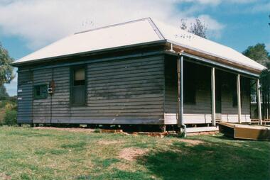
One of 9 photographs donated by Mrs ChampionColour photograph of Charmandene being prepared for move to 29 Osborne Avenue on 20/9/1988On back: "Verandah to be removed then ready for blocks to place on low-loader to take to new site at 29 Osborne Av. Cowes." "Charmandedn" Cowes. taken by Bruce Champion 7/9/1988. charmandene cottage, charmandene cowes phillip island, cowes phillip island, phillip island, mrs champion -
 Ringwood and District Historical Society
Photograph, Edwin G. Adamson A.R.P.S, Toilets in Civic Place, Ringwood, used by occupiers of 'The Block''. 1963 (Eastland Litigation Photo)
This series of SS0380 photos are part of the "Eastland Litigation" launched in 1962 by the Whitehorse Traders Co-operative Association (WTCA), against the Ringwood Council's Interim Development Order of 1960. WTCA sought "orders from the Supreme Court of Victoria that the planning scheme was invalid" - See "The Eastland Litigation" chapter in "From Horse Shoes to High Heels - Ringwood Shopping Centre and Eastland 1858-2008" by Richard Carter, Bounce Books 2009.Black and White PhotographWritten on back of photographs, 'Photo of toilets in Civic Place, used by occupiers of 'The Block''. Also stamped on photographs, 'Edwin G. Adamson...May 63' and 'In the Supreme Court, 1 Aug. 1963'. -
 St Kilda Historical Society
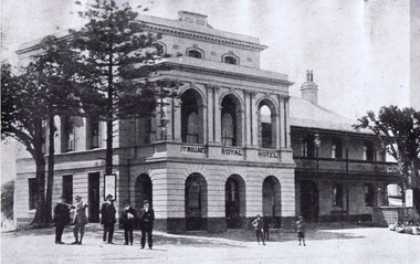
Photograph, Millar's Hotel, c. 1840 ?
black and white photograph mounted, fair conditionHand written on the back: Mooney's Royal Hotel, cnr Robe Street and Esplanade in the 1840s. Belvedere block of flats built 1929 (Hotel reads "Millar's Royal Hotel" on front of photograph) -
Creswick Campus Historical Collection - University of Melbourne
Still Image, 1956
Subject: Ballarat-Creswick Plantations Block A . 9 brown envelopes marked Run 3 No. 84 - 92 of c.76 prints total. 1 brown envelopes marked Run 4 No. 127-136 of 9 prints total. 1956. Marked up with red pen. Stored in a brown cardboard file box marked Ballarat-Cres.Plantation Block A. Run 3.Aerial Photographs -
 Bendigo Historical Society Inc.
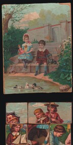
Leisure object - TOYS AND GAMES COLLECTION: PAPER COVERED WOODEN BLOCKS, c1930's
Object. Six paper covered wooden blocks. Childrens toy, not a complete set.(meant to be 12). Six different pictures can be made by changing the blocks around. Also one picture of one puzzle depicting two children in a garden scene near a pond. Picture appears to have been pasted onto the back cardboard of a notepad. On the back of picture - Joyce, Joyce Brown is no good, Chop her up for firewood, If she is no good for that, Give her to Mick Bennett.toys, general, blocks, wooden blocks paper covered -
Lakes Entrance Regional Historical Society (operating as Lakes Entrance History Centre & Museum)
Postcard, 1945c
North Arm Bridge and TownBlack and white small format postcard of bridge across North Arm, showing town and Club Hotel; jetties in Cunninghame Arm; sand dunes; and concrete brick toilet block built beside Highway between Club Hotel and North Arm. Concrete brick toilet block opposite road to Bullock Island built after World War 2 bricks made on Kimmels Farm, toilet at Harbecks Wharf and cricket club pavilion built same era. Lakes Entrance Victoriatownship, jetties, hotels, world war 1939 - 1945 -
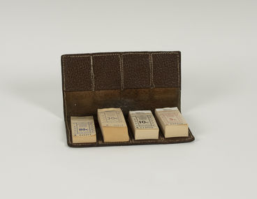 Ballarat Tramway Museum
Functional object - Ticket Wallet with 4 blocks of tickets
Used by conductors or conductors to retain and sell tickets from.Demonstrates the method of dispensing tickets by conductors, how the tickets could be arranged. Yields information about the style and printing of tickets used in Ballarat tramways and how they were presented.Sheet of leather, approx 2mm thick, stained brown with four pockets formed on each side with another sheet of leather, stitched on all sides to form pockets to hold eight blocks of tickets. Stitching is a white colour cotton. Has four blocks of tickets. 80c - blue - A 1016901 - Ballarat Vintage Tramway 30c - purple - A 69601 - Ballarat Tourist Tramway 10c - black - A 114000 - Ballarat Tourist Tramway 5c - red - A 137000 - Ballarat Tourist Tramwaybtm, ballarat tramway museum, ballarat tramways, tickets, ticket wallet, sec, conductors -
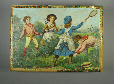 Tennis Australia
Block puzzle, Circa 1890
Block puzzle set. Contains 35 wood blocks covered with printed paper that can be arranged to make 6 different scenes. Housed in custom wooden box with hinge lid. Hinge is cloth tape. Box also contains five picture guide cards (sixth picture guide appears on box lid). Complete set. Small swinging metal hook as box closure device. Materials: Cardboard, Paper, Ink, Wood, Glue, Cloth tape, Metaltennis -
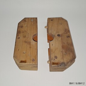 Flagstaff Hill Maritime Museum and Village
Equipment - Pattern, Briggs Brass Foundry, Early 20th century
The wooden patterns are part of a set that are stored in a strong wooden crate. It was used at Briggs’ Brass Foundry for making sand casts. It may fit together with one of the other patterns with a similar outline. The traditional craft of sand casting is over 2000 years old. The handcrafted process produces brass and copper alloy goods that are well suited to marine use; bells, boat hooks, cowls, propellers, handles, lids, rowlocks, hooks, letters, bolts, rail holders, brackets, deck plates, flanges, rudder guides, portholes and covers. Briggs’ Bronze mixture is a copper-based alloy made from local ingots of copper, tin, zinc and lead in carefully measured quantities. The finished product is non-ferrous and can last indefinitely. The crate of patterns was donated by the Briggs family in the early years of Flagstaff Hill, along with other related items such as brassware, tools and machinery. The donated items were displayed in a simulated Brass Foundry in the Village along with other working crafts, trades and services found in a Maritime town. The items were on show from the completion of the building in 1986 until 1994 when the building was repurposed. The patterns represent the trades of foundering and metalwork, both supporting maritime industries such as shipwrights and boatbuilders. Farmers, manufacturers and other local industries also needed the castings made by foundries. The Brass Foundry included a historic Cornish chimney set up as a working model, to tell the story of smelted metal heated in furnaces then be poured into the sand moulds. This chimney was made from specially curved bricks and is now about two-thirds of its full height when originally located at the Grassmere Cheese factory. The craft of sand-casting from carved wooden patterns to create metal is an example of skills from the past that are still used today. The foundry pattern set is significant for its association with brass foundries locally and generally in coastal areas of Victoria. Marine industries such as ship and boat building rely on good quality castings for their machinery, equipment and fittings. Briggs Brass was especially formulated using non-ferrous metals to ensure their longevity. The patterns are associated with the long-running firm Briggs Brass Foundry that specialised in cast goods for the marine industry, ready to supply the needs for once-off or mass-produced items. Their products would have been fitted to sail and steam vessels along coastal Victoria including Warrnambool. Briggs Marine was also a bell-founder specialist and is also associated with the Schomberg Bell at Flagstaff Hill, having restored it to is former state as a fine example of the bell from a luxury migrant vessel from the mid-19th century. Pattern; a pair of blocks that form a rectangle with a carved centre hole and disc shape inside. The block is made from laminated pieces of wood with cut corners. Both sides have four drilled holes in a square configuration but in different positions. The cut faces and the space carved into them are painted red; one piece has two dowel pins that fit into two drilled holes on the other. The pattern is part of a set of foundry patterns from Briggs Brass Foundry.flagstaff hill, flagstaff hill maritime museum and village, warrnambool, maritime museum, maritime village, great ocean road, shipwreck coast, briggs' bronze, traditional method, trade, sand cast, cast, brass alloy, copper alloy, pattern, mould, foundry, brass foundry, metal foundry, casting, sand mould, sand casting, marine equipment, marine tools, marine fittings, copper tin zinc lead, non-ferrous, non-corrosive, brassware, metalware, foundering, metalwork, maritime, bell founders, ship chandlers, marine products, biggs, briggs family, herbert harrison briggs, h h briggs, george edward briggs, cyril falkiner mckinnon briggs, cyril briggs, briggs & son brass foundry, h h briggs & sons foundry, briggs marine, alliance casting & engineering solutions, grassmere cheese factory, cornish chimney, curved bricks, collingwood, moorabbin, collingwood foundry, moorabbin foundry, 1912 -
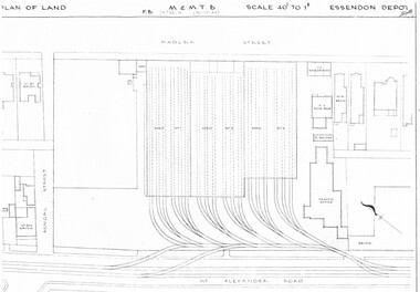 Melbourne Tram Museum
Drawing, Melbourne & Metropolitan Tramways Board (MMTB), "Essendon Depot", c1937
Set of three photocopied plans or drawings on A3 sheet of Essendon Depot - c1937 to 1944 .1 - P? - Plan showing depot block and building plan with adjacent private houses and properties - dated 30-12-1944 .2 - P8008 - Plan showing depot block and building plan with adjacent private houses and properties - dated 27-4-1937 .3 - P8089 - Detail plan of depot and offices, dated 27-4-1937 - prior to new offices being built.trams, tramways, drawings, depots, property, essendon depot -
 Melbourne Tram Museum
Administrative record - Depot Table Sheet or Block, Melbourne & Metropolitan Tramways Board (MMTB), "Sunday 14-1-1968 - Glenhuntly - North Fitzroy - Kew - Malvern - Doncaster", Jan. 1968
Depot table sheet or block - roneo or spirit duplicated, printed on light card - for - "Sunday 14-1-1968 - Glenhuntly - North Fitzroy - Kew - Malvern - Doncaster" shows the various runs and crew tables for the day, has an index and notes. The block was prepared for the track work to realign Dandenong Road and the Chapel St intersection as part of the St Kilda Junction project. See page 96 of Timeline History of Melbourne's Government Cable and Electric Trams - Barry George et al.trams, tramways, table cards, glenhuntly tram depot, kew depot, north fitzroy depot, doncaster depot, malvern depot, drivers, conductors, st kilda junction -
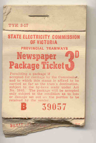 Ballarat Tramway Museum
Ephemera - Ticket/s, State Electricity Commission of Victoria (SECV), Block of 43 No. 3d Newspaper package Tickets, 1950's
Block of 43 No. 3d Newspaper package Tickets. Was originally a block of 50 two part printed ticket, using red ink on 60gsm cream paper with the top half part having a part gummed back, stapled with a single staple at the top onto a cardboard sheet. The ticket butt has the form number "TYE 3-17". The top portion was to be affixed to the newspaper package to be carried. It has the name of the organisation (SECV), "Newspaper Package Ticket 3d", conditions of carriage and ticket number, prefixed with the letter B. The first seven tickets have been removed or used. All the lower tickets have been torn from the top half of the block, it would appear in they were damaged. Tickets in the full book would have been numbered from B39050 to B39099.trams, tramways, secv, tickets, parcels -
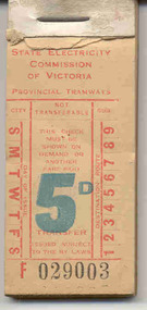 Ballarat Tramway Museum
Ephemera - Ticket/s, State Electricity Commission of Victoria (SECV), SEC 5d, 1940's?
Block of tickets each - red ink on 60 gsm buff paper, denomination 5d (printed in blue), numbered F029003 - F029049 (six missing) headed State Electricity Commission of Victoria, Provincial Tramways. Originally a block of 50 tickets been stapled onto a heavy cardboard back with a heavy metal staple and a small cardboard retaining strip at the top of the ticket. The ticket number is in black ink while the "E" prefix is in red, the ticket number is in black. Ticket used as a Transfer, had day of issue to be punched on the left hand side and the validated destination in number on the right hand side. Tickets 012 to 017 have been removed from block. Thought to be used prior to 1950's around the second world war.trams, tramways, secv, tickets, parcels -
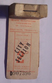 Ballarat Tramway Museum
Ephemera - Ticket/s, State Electricity Commission of Victoria (SECV), SEC 2d City Section, 1951 - 1965?
Yields information about the style and printing of tickets used in Ballarat and Bendigo tramways and how they were presented.Block with four remaining tickets - red ink on off white paper, denomination 2d, over stamped in black "City Section" numbered D907396 - 99, headed State Electricity Commission of Victoria, Provincial Tramways. Originally a block of 200 tickets been stapled onto a plain cardboard back with a heavy metal staple and a off white coloured cardboard retaining strip at the top of the ticket. The ticket price is in red ink while the ticket number itself and prefix is in black ink. On rear in red ink is a diagonal criss cross or tartan pattern. See also Reg Item 4002 for another 2d City Section ticket - block of 100 tickets and larger font for the price. See Alan Bradley's notes "Fares in Ballarat" trams, tramways, secv, tickets -
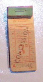 Ballarat Tramway Museum
Ephemera - Ticket/s, State Electricity Commission of Victoria (SECV), SEC 3d concession, 1955? - 1965?
Yields information about the style and printing of tickets used in Ballarat and Bendigo tramways and how they were presented.Block with 4 remaining ticket - orange ink on off white paper, denomination 3d, overprinted "Concession" in black, numbered A010646 - 49, headed State Electricity Commission of Victoria, Provincial Tramways. Originally a block of 50 tickets been stapled onto an off white, ruled on one side cardboard back with a heavy metal staple and an green coloured cardboard retaining strip at the top of the ticket. The ticket price is in orange ink while the ticket number itself is in black ink. On rear in orange ink is a diagonal criss cross or tartan pattern. See also Reg Item 3989 for another 2d Concession - block of 100 tickets. Note: "L.P.L." in bottom right hand corner of ticket. See Alan Bradley's notes "Fares in Ballarat" On the inside of the cardboard back are notes re City, Junc and To columns using the ruling on the ticket and notes. Not sure what the purpose of these are.trams, tramways, secv, tickets -
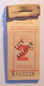 Ballarat Tramway Museum
Ephemera - Ticket/s, State Electricity Commission of Victoria (SECV), SEC 2d City Section, 1951 - 1965?
Yields information about the style and printing of tickets used in Ballarat and Bendigo tramways and how they were presented.Block with 22 remaining tickets - red ink on off white paper, denomination 2d, over stamped in black "City Section" numbered C873578 - 99, headed State Electricity Commission of Victoria, Provincial Tramways. Originally a block of 100 tickets been stapled onto an off white cardboard back, ruled on one side with a heavy metal staple and a off white coloured cardboard retaining strip at the top of the ticket. The ticket price is in red ink while the ticket number itself and prefix is in black ink. On rear in red ink is a diagonal criss cross or tartan pattern. See also Reg Item 3990 for another 2d City Section ticket - block of 200 tickets and smaller font for the price. See Alan Bradley's notes "Fares in Ballarat" On the inside of the cardboard back are notes using two of the columns using the ruling on the ticket and notes. Not sure what the purpose of these are.trams, tramways, secv, tickets -
 Eltham District Historical Society Inc
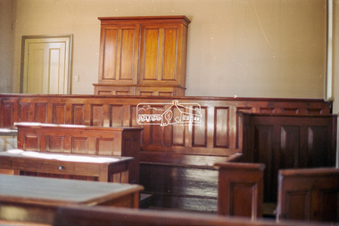
Negative - Photograph, Harry Gilham, Interior, Eltham Courthouse, 730 Main Road, Eltham, Sep 2004
The cupboard (containing 48 pigeon holes) was moved from Clerk's Office to 'block' the fireplace behind the Magistrate's bench in 2004eltham courthouse -
 Eltham District Historical Society Inc
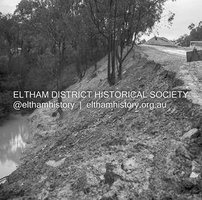
Negative - Photograph, J.A. McDonald, Heidelberg-Kinglake Road, Sep 1959
Job 56M430 Contractor Hone Wash over road due to blocked table drain caused this wash out on embankmentRecord of various Shire of Eltham infrastructure works undertaken during the period of 1952-1962 involving bridge and road reconstruction projects, sometimes with Eltham Shire Council Project Reference numbers quoted. It was during this period that a number of significant improvements were made to roads and new bridges constructed within the shire that remain in place as of present day (2022). In many situations, the photos provide a tangible visible record of infrastructure that existed throughout the early days of the Shire. The album was put together by or under the direction of the Shire Engineer, J.A. McDonald.infrastructure, shire of eltham, bridge construction, 1959-09, heidelberg-kinglake road, road construction -
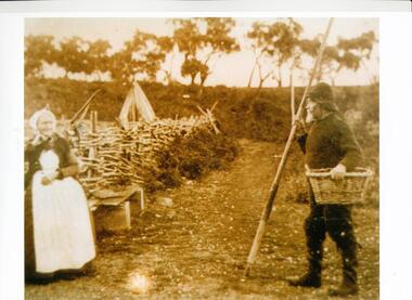 Phillip Island and District Historical Society Inc.
Photograph, Charles & Margaret Grayden, Late 1800's
Margaret & Charles Grayden owned blocks 33 & 34 from 1868, near George Ames Drive to Churchill Island. Sepia photograph of Margaret & Charles Grayden, possibly at Newhaven.margaret & charles grayden, bernard grayden