Showing 3443 items matching "distance"
-
 Kew Historical Society Inc
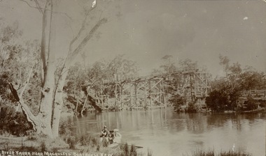
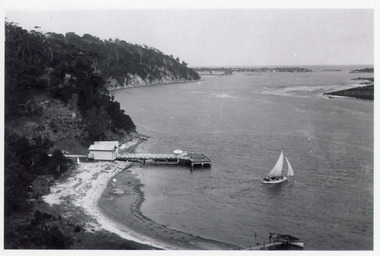
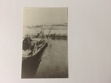
Postcard, River Yarra near Macauleys' Boathouse Kew
Sepia postcard of the Zig-zaf Bridge joining Yarra Bend and Studley Park. In the foreground is a rowboat in which a man is standing, behind whom are two women in hats and a young child. The man appears to be pushing the boat away from the Bank. In the distance is the wooden Zig-Zag Bridge, constructed in the 1870s to link the Yarra Bend and Kew Lunatic Asylums. [Destroyed by flood, 1929.]Obverse: "River Yarra near Macauleys' Boathouse Kew". Reverse: "Zig Zag Bridge / Gift from L Bennett 1980 / Bridge between Old Asylum & new Mental Hosp. / Kew side"zig-zag bridge -- kew (vic.), bridges -- river yarra, bridges -- kew (vic.) -
 Bendigo Historical Society Inc.
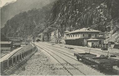
Postcard - ROY AND DORIS KELLY COLLECTION: STAZIONE D'ISELLE E TRASQUERRA (STRADA DEL SEMPIONE), CARTE POSTALE, 1900-1920
Postcard, B&W photo of the railway station serving the villages of Iselle and Trasquerra in the Piedmont region of north west Italy. It was opened in 1906. The rail tracks lead to the entrance of the Simplon Tunnel in the distance. An empty flat tray carriage sits on the tracks (lower right). Part of the the Simplon road (Strada del Sempione) is shown at lower left. This road connects Italy to Switzerland.postcard, photograph, postcard, iselle, trasquerra, italy, station, simplon tunnel. -
 Bayside Gallery - Bayside City Council Art & Heritage Collection
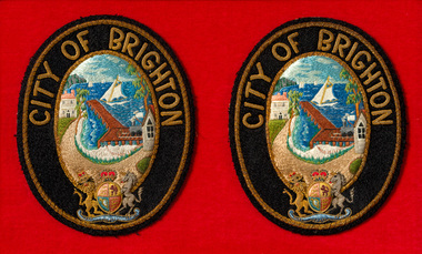
Ceremonial object - Badge, City of Brighton Mayoral robe badges
This pair of embroidered badges were worn on the sleeves of the red City of Brighton mayoral robes until Coat of Arms were granted in 1970 by the British College of Heraldry. Brighton was first incorporated as a borough on 18 January 1859, it became a town on 18 March 1887 and was proclaimed a city on 12 March 1919.Two oval shaped City of Brighton mayoral robe badges, embroidered and mounted on red felt. The badges have a black border with CITY OF BRIGHTON embroidered on the top and the British Coat of Arms on the bottom. The centre image depicts the City of Brighton seal of the Brighton coastline with a pier extending to the water, sail boats in the distance, a train on the right of the pier, and buildings on the left and right sides. coat of arms, mayoral robe badges, badge, mayoral robe, city of brighton, ceremonial wear, mayoral regalia, bayside, crest, british coat of arms, brighton, seal -
 Lakes Entrance Historical Society
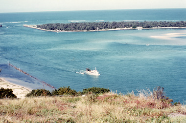
Photograph - The Entrance, Fraser, Ian, 1990c
Colour photograph of the lake. It shows a fishing boat with scallop dredge moving up the lake opposite the artificial entrance, grassy edge of Jemmy's Point in foreground above highway guard fence, rock groyne at entry to North Arm, sandy shallows at entry to Hopetoun Channel, scrub covered hummocks of south shore and Bass Strait in distance. Lakes Entrance Victoriaislands, waterways, topography -
 Lakes Entrance Historical Society
Postcard - Kalimna Jetty, Bulmer H D, 1920c
Black and white postcard of Kalimna Jetty. It shows a jetty with painted railings, storage shed with square water tank, low lying shore of lake in foreground contrasting with steep cliffs beyond jetty. Boat moored at a small jetty in foreground, yacht sailing from jetty, glimpse of Rigby Island and Bullock Island and the New Works area in distance. Lakes Entrance Victoriajetties, waterways, islands, boating -
 Bendigo Historical Society Inc.
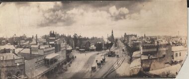
Photograph - CARWARDINE COLLECTION: STREETVIEW CHARING CROSS AND VIEW POINT, BENDIGO
Black and white photo. Image shows Charing Cross and View Point, looking northwards up Pall Mall (taken from City Family Hotel?) View Point businesses evident are : National and Mutual Life; A.M. Armstrong newsagents with 'The Argus popular daily ' on front; Moran and Cato, Warren's View Point Hotel, with two storey veranda ( on side: Cameo Cigarettes). Tram in foreground in View Street approaching fountain. Hustler's Royal Reserve poppet head and chimney on western side of Pall Mall, smoke rising from engine house? Post Office building with clock tower in distance. On RH side of image: written on verandah, Woodrow's Southern Cross Hotel; E.L. Holdsworth Chemist and Shamrock Hotel in distance. Four horse drawn taxis in centre of Charing Cross roadway, near fountain. Receipt number 355/16bendigo, business, carwardine soap and candle -
 Kiewa Valley Historical Society
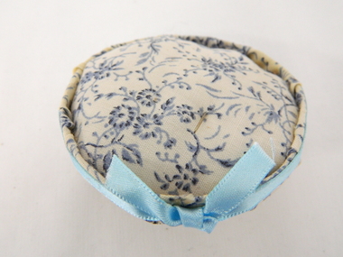
Cushion Pin, unknown, circa mid to late 1900's
This pin cushion was in use when home spun "fashion" clothing was manufactured or altered. When this item was used it was in a period when distances from haberdashery stores was too far and mail ordered clothing would take weeks to arrive.The ability to make and alter clothing for families within the Kiewa Valley and its regions was a domestic requirement up until the later period(1960's onwards)This pin cushion, although rarely used in the 21st Century, with the availability of "cheap" throw away clothes, was very important to a well run rural household. The emphasis for girls to be able to sew and repair clothing was generated by mothers and continued at high schools. Part of the role of women(in this time frame) within the family was to manufacture children's clothing and adjust the growing waistline of their men folk. This item is very significant to the rural households in the Kiewa Valley because of the relative isolation of the region and the amount of wear and tear that clothes go through in a typical rural environment.This pin cushion is "home" made, circular and covered in a blue floral material, encircled with a light blue ribbon (glued on) for extra adhesion. The material encloses a padded surface(allows pins to be safely inserted for storage(future use).sewing, pin-cushion, haberdashery -
 Vision Australia
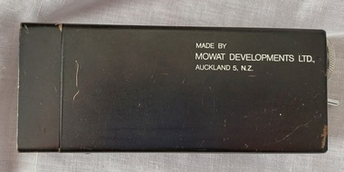
Equipment - Object, Mowat Developments Ltd, Mowat Sonic Sensor, 197
Created prior to the Mowat-Wormald development, this prototype emits a beam of ultrasonic sound that detects reflection from objects and obstacles as well as vibrate when the object is within range. The rate of vibration increases the distance reduces and was designed to be used in conjunction with other mobility aids such as a cane or a dog. With a simple toggle switch, it could be operated easily or stored safely away due to it's compact size.A small black rectangular metal container with mesh on one aend and a switch and tuning dial on the other end.Model MS01assistive devices, orientation and mobility -
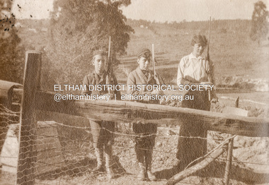 Eltham District Historical Society Inc
Photograph, Mervyn, Bill and Dall on guard at Southernwood, 1916
Charles Withers (aka Bill) with his good friend from school, Mervyn Britain and his eldest sister Emily (aka Dall) with mock trenches and rifles at the Withers family home, Southernwood, Eltham. The view is looking to the east with Main Road and associated buildings near ridge in distance. [Charles son, John Withers explained that his father and friend liked to play war games.]"Mervyn, Bill and Dall 1916" Many items in this collection have suffered from significant water damage and black mouldjohn withers collection, eltham, 1916, main road, southernwood, trenches, mervyn britain, emily gladys withers, charles meynell pitt withers -
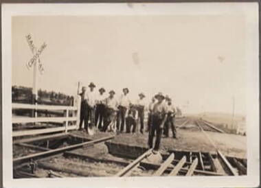 Sunbury Family History and Heritage Society Inc.
Photograph, Sunbury Railway crossing, C 1930s
The 11 workmen are standing at the Sunbury railway crossing facing towards the south. It was in Station Street. In the distance the Sunbury Asylum hill is on the LHS. The men are from the Diggers Rest railway gang. Standing in the immediate front is Jim Brain and front left is Malic Cahill, seated is the ganger, Clary Grimmet, 3rd from right is Phil O'Conner, son of Frank and 5th from left is Mick Frouly. It wasn't until 2023 that the level rail crossing at Sunbury was removed by redirecting Station Street under it as part of the Victorian Government's program to remove level rail crossings in built-up areas.A black and white non-digital photograph with a cream border of 11 men standing at a closed country rail crossing. The photograph has been pasted onto a piece of brown light cardboard. In formation about the people in the photograph is on a separate sheet of paper.sunbury rail crossing, station street, railway gangers, railways, jim brain, malic cahill, clary grimmet, frank o'connor, mick frouly -
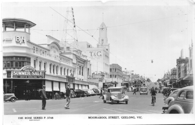 Ballarat Tramway Museum
Postcard, Rose Stereograph Co, "Moorabool Street Geelong Vic", 1949
Postcard produced by the Rose Stereograph Co. No P 3748, showing the scene at the corner of Moorabool and Ryrie Sts Geelong. Has a tram in the far distance along with many motor cars of the late 1940s. In the view are Bright and Hitchcocks, the T&G building, Bank of NSW. The rear of the postcard notes that it is a real photograph. Based on the pencil notation on the rear of item 9059, photo dated 1949.Yields information about the view of Moorabool St at Ryrie St.Black and white Postcard divided back, unused. tramways, trams, geelong, moorabool st, ryrie st -
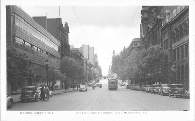 Melbourne Tram Museum
Postcard, Rose Stereograph Co, "Collins Street looking east, Melbourne", late 1940s
Rose Series postcard No. P 2618, titled "Collins Street looking east, Melbourne", Photo shows W2 class tram 543 about to arrive at its Collins and Spencer Streets destination. The return destination has been reset to Kew route 42. Another W2 is in the far distance. The McPherson’s Pty Ltd. building on the left was built 1934-37. Photo late 1940sYields information about the west end of Collins St late 1940s.Postcard - printed real photograph with Rose Stereograph Co. name on the rear.tramways, trams, collins st, w2 class, tram 543, route 42 -
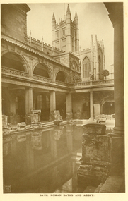 Federation University Historical Collection
Postcard - Postcard - Sepia, Bath, Roman Baths and Abbey
The Roman Baths complex is a site of historical interest in the English city of Bath. The house is a well-preserved Roman site for public bathing. The Roman Baths themselves are below the modern street level. There are four main features: the Sacred Spring, the Roman Temple, the Roman Bath House and the Museum, holding finds from Roman Bath. The buildings above street level date from the 19th century. Three sepia postcards with a photographic impressions of the Roman Baths, Abbey, and Grand Pump Room, Bath. All postcards unwritten..3) Bath. Roman Baths and Abbey. Within the distance of a few yards are the Roman Baths, built about A. D. 55 ; the Abbey, erected in 1499 : the King's Bath of 17th and 18th century construction, and the modern Bathing establishment containing the latest scientific appliances for the administration of the radio-active waters for the cure and relief of many complaints.bath, roman baths, roman, archeaology -
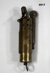 Bendigo Military Museum
Functional object - CIGARETTE LIGHTER WW1, Imperial German Army
This is a two part brass cylindrical object. The two pieces slide apart a small distance. This mechanism when operated removes a cap from the wick. On the side is a square, long section that holds a flint & string. On the tip of this section is a circular wheel with a serrated edge. When the inner section is slid down a little, the flame is shielded from the wind by the holes in the outer section. There is a ring mounted in the bottom., Engraved on one side are the letters CFA. Engraved on side of square section is "Patent 91 105107". On other side of square section are the words "Made in Austria". Pat 105107cigarette lighter, souvenir, smoking -
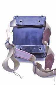 Montmorency–Eltham RSL Sub Branch
Equipment - Navigational Computer
Rectangular calculating instrument with (1) 'hinged lid' fitted with circular rotating dial for setting/reading altitude, speed, distance and temperature, (2) notebook inside lid, (3) circular dial with perspex cover, beneath which is (4) graph chart, moveable up-and-down by means of rotating knob on side of device. Curved brackets and elasticized straps on back for strapping onto pilot's leg.R.A.A.F. Ident. No. G6B/145 Serial No. WG/2233 COMPUTER NAVIGATIONAL Mk. III D. (Other inscriptions including instructions for use and scales for various measurements) "AB" hand written on strap (owner's initials?) -
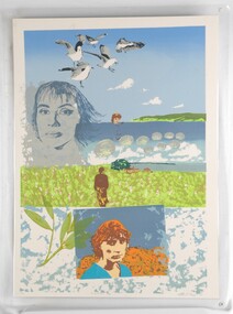 Glenelg Shire Council Cultural Collection
Print, Bridgewater Bay, 1983
CEMA Art Collection. Part of "A Community View" 150 years in Portland Screenprint Exhibition. Part of Angela Gee Residency 1983 and 1984.Laminated screenprint of females in various landscapes. The top half of the work features the ocean, coastline and breaking waves. Super imposed on this are images of: five seagulls; a blue portrait of a female face; and a female torso and head. In the centre of the work a female stands looking towards a house and the ocean in the distance. The lowest section of the work features the image of a female face in a blue and orange rectangle. To the left of her is a twig.Front: 14/16 Bridgewater Bay. Catherine Taylor '83 Back: 42 -
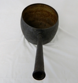 Kiewa Valley Historical Society
Saucepan, circa mid to late 1900's
This large deep pan (with a long handle) was used by pioneer families, mainly rural folk, that needed a pan which could cope with an open fire heat source, in or mainly outside the homestead. This pan was used in the early to late 1900's for the "stews" and other meals required by hard working stock men and farmers that had irregular "lunch and dinner" breaks under sometimes hard and gruelling conditions. Hot plates were normally not in use.This "open fire" saucepan belonged, and was used by a Kiewa Valley, pioneer family, the Roper Family. This saucepan was moved from their Kiewa Valley property to their hut built on the Bogong High Plains. This saucepan was one of an array of "open fire" cooking utensils used in the "camp draft" grazing in the Bogong High Plains and this could take up to six weeks. This kettle belonged and was used by a Kiewa Valley, pioneer family, the Roper Family. This kettle was moved from their Kiewa Valley property to their hut built on the Bogong High Plains. A scientific study started in 1947 to study the impact of grazing cattle on the natural Alpine and sub Alpine vegetation found grazing cattle had an adverse affect on the natural Alpine and sub alpine vegetation, and grazing on the plains was stopped by the Victorian Government in 2005.This large (black, soot infused) cast iron saucepan has a "ten pint" holding capacity and was used on the "open fire", possible on the fire direct. It has a long all metal handle coming from the top half of the pot and angled at approximately sixty degrees upwards. This angle insures that both distance from flame intensity and least bending of knees when lifting is at a minimum.On bottom of pan (underside) "N0. 8 JSJ SIDDONS" on the other side "WEST BROMWICH 5 QUARTS"camp fire cooking utensils, hot plate, cast iron cooking appliance, drovers kitchen -
 Flagstaff Hill Maritime Museum and Village
Equipment - Hand Barrow, 1860s
This hand barrow, sometimes called a Welsh hand barrow, was used to transport a load of marine rescue equipment from the beach cart to the rescue site, particularly over hilly, uneven or rough terrain. Hand barrows were in common use in the 19th century. Saving lives in Warrnambool – The coastline of South West Victoria is the site of over 600 shipwrecks and many lost lives; even in Warrnambool’s Lady Bay there were around 16 known shipwrecks between 1850 and 1905, with eight lives lost. Victoria’s Government responded to the need for lifesaving equipment and, in 1858, the provision of rocket and mortar apparatus was approved for the lifeboat stations. In 1859 the first Government-built lifeboat arrived at Warrnambool Harbour and a shed was soon built for it on the Tramway Jetty, followed by a rocket house in 1864 to safely store the rocket rescue equipment. In 1878 the buildings were moved to the Breakwater (constructed from 1874-1890), and in 1910 the new Lifeboat Warrnambool arrived with its ‘self-righting’ design. For almost a hundred years the lifesaving and rescue crews, mostly local volunteers, trained regularly to rehearse and maintain their rescue skills. They were summoned when needed by alarms, gunshots, ringing bells and foghorns. In July 1873 a brass bell was erected at Flagstaff Hill specifically to call the rescue crew upon news of a shipwreck. Some crew members became local heroes but all served an important role. Rocket apparatus was used as recently as the 1950s. Rocket Rescue Method - Rocket rescue became the preferred lifesaving method of the rescue crews, being much safer that using a lifeboat in rough seas and poor conditions. The Government of Victoria adopted lifesaving methods based on Her Majesty’s Coast Guard in Great Britain. It authorised the first line-throwing rescue system in 1858. Captain Manby’s mortar powered a projectile connected to rope, invented in 1808. The equipment was updated to John Dennett’s 8-foot shaft and rocket method that had a longer range of about 250 yards. From the 1860s the breeches buoy and traveller block rocket rescue apparatus was in use. It was suspended on a hawser line and manually pulled to and from the distressed vessel carrying passengers and items. In the early 1870s Colonel Boxer’s rocket rescue method became the standard in Victoria. His two-stage rockets, charged by a gunpowder composition, could fire the line up to 500-600 yards, although 1000 yards range was possible. Boxer’s rocket carried the light line, which was faked, or coiled, in a particular way between pegs in a faking box to prevent twists and tangles when fired. The angle of firing the rocket to the vessel in distress was measured by a quadrant-type instrument on the side of the rocket machine. Decades later, in about 1920, Schermuly invented the line-throwing pistol that used a small cartridge to fire the rocket. . The British Board of Trade regularly published instructions for both the beach rescue crew and ship’s crew. It involved setting up the rocket launcher on shore at a particular angle, determined by the Head of the crew and measured by the quadrant, inserting a rocket that had a light-weight line threaded through its shaft, and then firing it across the stranded vessel, the line issuing freely from the faking board. A continuous whip line was then sent out to the ship’s crew, who hauled it in then followed the instructions – in four languages - on the attached tally board. The survivors would haul on the line to bring out the heavier, continuous whip line with a tail block connected to it. They then secured the block to the mast or other strong part the ship. The rescue crew on shore then hauled out a stronger hawser line, which the survivors fixed above the whip’s tail block. The hawser was then tightened by the crew pulling on it, or by using the hooked block on the shore end of the whip and attaching it to a sand anchor. The breeches buoy was attached to the traveller block on the hawser, and the shore crew then used the whip line to haul the breeches buoy to and from the vessel, rescuing the stranded crew one at a time. The rescue crew wore scarlet, numbered armbands and worked on a numerical rotation system, swapping members out to rest them. This hand barrow is significant for its connection with local history, maritime history and marine technology. Lifesaving has been an important part of the services performed from Warrnambool's very early days, supported by State and Local Government, and based on the methods and experience of Great Britain. Hundreds of shipwrecks along the coast are evidence of the rough weather and rugged coastline. Ordinary citizens, the Harbour employees, and the volunteer boat and rescue crew, saved lives in adverse circumstances. Some were recognised as heroes, others went unrecognised. In Lady Bay, Warrnambool, there were around 16 known shipwrecks between 1850 and 1905. Many lives were saved but tragically, eight lives were lost.Hand barrow; a transporting device carried between two people walking one in front of the other. A wooden ladder-like frame with two handles at each end, blue painted body with unpainted handles. Seven equal-length slats are joined at equal distance between two parallel poles, and two longer slats are attached diagonally between the first and last slats as a brace. flagstaff hill maritime museum and village, flagstaff hill, maritime museum, maritime village, warrnambool, great ocean road, lady bay, warrnambool harbour, port of warrnambool, tramway jetty, breakwater, shipwreck, life-saving, lifesaving, rescue crew, rescue, rocket rescue, rocket crew, lifeboat men, beach rescue, line rescue, rescue equipment, rocket firing equipment, rocket rescue equipment, maritime accidents, shipwreck victim, rocket equipment, marine technology, rescue boat, lifeboat, volunteer lifesavers, volunteer crew, life saving rescue crew, lifesaving rescue crew, rocket apparatus, rocket rescue method, shore to ship, rocket apparatus rescue, stranded vessel, line throwing mortar, mortar, rocket rescue apparatus, line thrower, line throwing, lifeboat warrnambool, hand barrow, manual transport, welsh hand barrow -
 Federation University Historical Collection
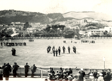
Photograph - Black and White, Band Contest at Basin Reserve, Wellington, New Zealand, 1940, February 1940
Frank Wright was a renown resident of Smeaton, where he was born. He lived at Laura Villa, and attended Smeaton State School. His father William was a gold miner and his mother's name was Sarah. Their family won many singing and instrumental awards. Frank was tutored by Percy Code and was awarded a gold medal for the highest marks in the ALCM examinations in the British Colonies at the age of seventeen years. He became the Australian Open Cornet Champion by the age of eighteen. A year later, Frank conducted the City of Ballarat Band, and later the Ballarat Soldiers’ Memorial Band. He formed the Frank Wright Frisco Band and Frank Wright and his Coliseum Orchestra. These bands won many South Street awards, and Frank as conductor won many awards in the Australian Band Championship contest. In 1933 Frank Wright sailed to England to conduct the famous St Hilda’s Band and was later appointed Musical Director of the London County Council (the GLC or Greater London Council), where he organized many amazing concerts in most of the 150 parks, in and around the London district. He was also responsible for some of London’s major concerts at Kenwood, the Crystal Palace and Holland Park. He was made Professor of Brass and Military Band Scoring and conducted at the Guildhall of Music and Drama. Frank was often invited to adjudicate Brass Band Championships around Europe, in Australia, including South Street and in New Zealand. The Frank Wright Medal at the Royal South Street competition is awarded to an individual recognized as making an outstanding contribution to brass music in Australia.1). Black and white photograph of an oval and spectators in the foreground and houses beyond the far fence, with mountains in the distance. On the oval are several bands in different areas. The place is Basin Reserve, Wellington and the occasion is the band contest. 2). Newspaper photograph and caption of an oval with spectators in the foreground and brass bands formed in a square around a raised platform on which is standing the conductor. The place is Wellington and the conductor is Frank Wright.1). Written in pencil on the back - Band contest at Basin Reserve Wellington, Feb 1940 2). Written in pencil on left side - Free Lance Feb 1940frank wright, conductor, brass band, basin reserve, wellington, adjudicator -
 Federation University Historical Collection
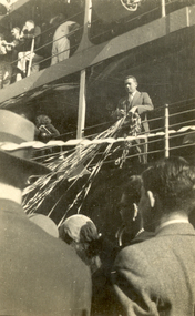
Photograph - Photograph - Black and White, Herald, Frank Wright departing Australia, 1933, 5/8/1933
Frank Wright was a renown resident of Smeaton, where he was born. He lived at Laura Villa, and attended Smeaton State School. His father William was a gold miner and his mother's name was Sarah. Their family won many singing and instrumental awards. Frank was tutored by Percy Code and was awarded a gold medal for the highest marks in the ALCM examinations in the British Colonies at the age of seventeen years. He became the Australian Open Cornet Champion by the age of eighteen. A year later, Frank conducted the City of Ballarat Band, and later the Ballarat Soldiers’ Memorial Band. He formed the Frank Wright Frisco Band and Frank Wright and his Coliseum Orchestra. These bands won many South Street awards, and Frank as conductor won many awards in the Australian Band Championship contest. In 1933 Frank Wright sailed to England to conduct the famous St Hilda’s Band and was later appointed Musical Director of the London County Council, where he organized many amazing concerts in parks, in and around the London district. He was made Professor of Brass and Military Band Scoring and conducted at the Guildhall of Music and Drama. Frank was often invited to adjudicate Brass Band Championships around Europe, in Australia, including South Street and in New Zealand. The Frank Wright Medal at the Royal South Street competition is awarded to an individual recognized as making an outstanding contribution to brass music in Australia..1) Black and white photograph of the torso of a man wearing a suit, leaning against ship's railing and holding streamers. The man is Frank Wright and the ship is 'Balranald'. .2) Black and white photograph of two levels of the side of a ship with passengers standing at the railings. In the middle distance is a man leaning against the railing, holding streamers and in the foreground are the backs of a crowd of men. The man is Frank Wright and the ship is 'Balranald'..1) Printed on back - Post Card, Kodak Handwritten in pencil on back - Frank Wright, Taken by Herald photographer when boat ("Balranald") was leaving Port Melbourne for London, Aug 5th 1933 Stamped on back - An indistinct "Copyright Herald ..." stampfrank wright, cornet, conductor, ballarat, st hilda's band, herald, balranald, port melbourne -
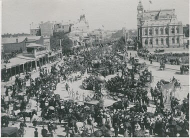 Bendigo Historical Society Inc.
Photograph - EASTER FAIR PROCESSION 1895, 1895 ?
black and white photograph: parade in Pall Mall, showing shops, hotels,EXCHANGE' Shamrock Hotel, City Family Hotel in distance. Post office tower and Law Courts. Banners, floats and people marching. Large crows watching. Horse drawn vehicles with occupants watching parade. Note ' Union Jack' flag on Law Courts. On back top right corner. ' MP 256'cottage, miners -
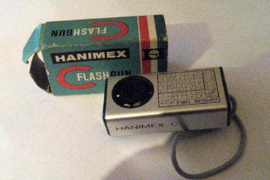 Whitehorse Historical Society Inc.
Functional object - Flashgun, 1970
Haminex C Flashgun (code 14-009) in its original box. The flash Gun uses Flash Cubes (no sample) and can be fitted to camera via together with a short cord and plug to connect to the camera shutter. It has a exposure table for distance and film speed, and a lever to turn the cube around to one of its four surfaces. The unit uses a 15 Volt No.404 battery for the flash.Hanimex C 7 Exposure Tablephotography, cameras -
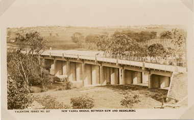 Kew Historical Society Inc
Postcard, Valentine Publishing Co Pty Ltd, New Yarra Bridge, Between Kew and Heidelberg, 1926-1930
Without bridges, Kew remained cut off from the City of Melbourne, only being accessible by Punt. Private and public bridges were constructed from the 1850s, beginning with the Hawthorn Bridge linking Bridge and Burwood Roads. A bridge across the Yarra at Burke Road was created as early as 1873. Since that first wooden bridge, a number of later bridges, typically on concrete pylons have been built, in 1926 and again during the 1970s.Angle view of the new Yarra bridge [ie. The Burke Road bridge] taken from the Kew side, showing the bridge’s structure. Trees line the river’s edge. In the distance can be seen a distant line of houses stretching to the horizon. The river appears to have an S-shaped bend beyond the bridge. The postcard, No. 227, was produced by the Valentine Publishing Co. Pty Ltd., of Queen Street, Melbourne.burke road bridge - kew (vic), bridges - kew (vic) -
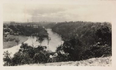 Kew Historical Society Inc
Photograph - Yarra River, Studley Park, 1924
Henry Beater Christian (1886-1962) , was a descendant of one of the earliest settler families in Kew. Employed at the Kew Asylum as a 'public servant', he was a skilled amateur photographer, photographing numerous scenes in Kew and on his travels around Victoria. The majority of his photographs date from 1916 to 1929. His finest photographs are housed in two photograph albums. Digital copy of a photograph from page 7 of the 47-page photograph album containing 261 gelatinous silver images, loaned by Diane Washfold with permission given to digitise and hold a copy in our collection. This photograph was taken during a flood year when the Yarra encroached on the grounds of the Abbotsford Convent. In the distance, the Johnston Street Bridge separates the viewer from the industrialised landscape of Fairfield."Studley Park / Kew"henry beater christian (1886-1962), landscape photography, kew (vic.) — yarra river, christian-washfold collection, photograph albums, fairfield, kew, johnston street bridge, studley park -
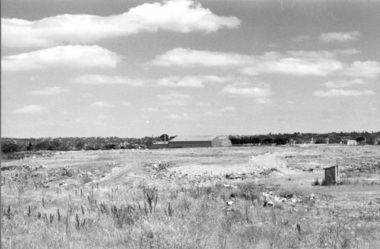 Darebin Parklands Association
Rockbeare Park 1970s, 1973-1980
B&W photograph of the area which was to become the Darebin Parklands. Shows tip site and makeshift toilet probably from the days of the former bluestone quarry. Darebin Enterprise Centre is in the distance. This item and all other Darebin Parklands Association archival material is now held by State Library Victoria (Accession No: YMS 13746). Please contact State Library Victoria if access is required. -
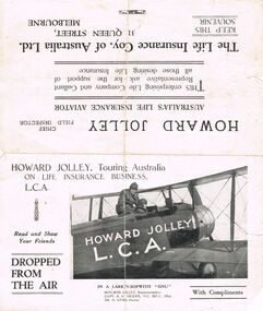 Bendigo Historical Society Inc.
Document - HOWARD AND VIOLET JOLLEY COLLECTION: PAMPHLET
This pamphlet is and advertising flyer for The Life Insurance Coy. Of Australia Ltd. And advertises the services on offer. Howard Jolley is a representative of this Company, and has at his disposal an aeroplane that will allow him to visit prospective clients located at great distances from the Office. The aeroplane is a Loarkin-Sopwith 'GNU', crewed by Howard Jolley, representative, Capt. A. W. Vigers, M.C. D.F.C., Pilot and Dr H. Webb, Doctor.business, retail, insurance, the life insurance coy. of australia ltd. howard jolley, capt. a. w. vigers m.c. d.f.c. pilot, and dr. h. webb. doctor. -
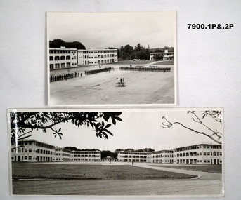 Bendigo Military Museum
Photograph - SELARANG BARRACKS, 1970
Various photos of Selarang Barracks in Singapore in 1970. Some aerial and some ground level views. Refer items in Collection of LLoyd Farrell. Refer Cat 7889P.1. Photo of 1 RAR on parade for Trooping of the Colours in 1970 at Selarang Base in Singapore. Covering 'A' 'B' 'C' and Admin Company. 2. Extended portrait photo of the Parade Square and buildings of Selarang Base, Singapore in 1970. 3. Aerial photo of Selarang Barracks from a distance. 4. Aerial photo of Selarang Barracks 1970. 5. Aerial photo of Changi Prison 1970 in Singapore.Written on back. 1. "1 M1+" 2. “Selarang Barracks 1970 occupied by 1st RAR” 4. “Selarang 70” 5. "Changi Prison 1970 Singapore".photograhs, changi, selarang, 1970, lloyd farrell. -
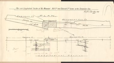 Bendigo Historical Society Inc.
Document - MCCOLL, RANKIN AND STANISTREET COLLECTION: MONUMENT HILL CO., DEBORAH CO. LEASE ON DEBORAH LINE
Plan of Monument Hill Co., and Deborah Co. leases on the Deborah line. Black line drawing, showing longitudinal section. 'Deborah shaft to Nth Deborah 1100 ft ' noted in pencil . 'Nth Deborah shaft to Central Deb shaft 2000ft' in pencil. Other pencil notation on map re distance of leases. Map is attached to back page of booklet, rest of information missing.business, mining, mccoll rankin & stanistreet -
 Port of Echuca
Black and white photograph, Approx. 1980
Black and white photograph of an unknown lock scene where 3 men are working from a hollow platform structure, with one person being a diver coming up or going down a ladder. Another person appears to have hold of a hose (could be oxygen) and the back view of the other person appears to be working with them watching what is happening. This could be part of lock construction as there appears to be cranes and a tripod in the distance.This black and white photograph demonstrates historical and social significance in that it gives a close up view of workmen in the process of lock construction. It appears that there is a diver suited up with helmet on, descending the ladder and a person holding what appears to be hose connected to the person diving. This scene is possibly from the beginning of the 20th century and could be about the development of the irrigation industry.Black and white photograph , portrait format, of 3 men on a hollow platform structure in a river. One man is a diver and is on a ladder which steps down into the water. Copy of an original photograph. On reverse in pencil: Price, Lock scene, location Unknown. lock scene, lock construction, price family collection, irrigation industry -
 Ballarat Tramway Museum
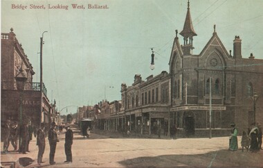
Postcard - copy, WTP, "Bridge Street looking west, Ballarat"
Bridge St looking West from Peel St. Has a bank on the corner and an tram in the distance. Card dates the view as early 1900's. Card reproduced for Sovereign Hill Gold Mining Township by Rose Stereograph Co. of Glen Waverley c2000. Divided back type with caption, production and the Rose Co. symbol on the rear. Illustration of the same image added 4-1-2024 - by WTP & Co.Yields information about the appearance of Bridge St following the introduction of electric trams in 1905 and has a strong association with the work of Sovereign Hill and Rose Stereograph Co.Postcard reproduction - part sepia coloured and hand coloured. Second copy printed coloured illustration on plain paper.trams, tramways, bridge st, ballarat, esco, rose postcards