Showing 3571 items matching "environments"
-
 Eltham District Historical Society Inc
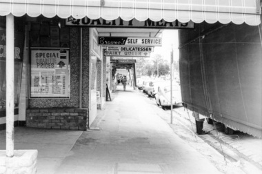
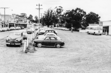
Photograph, Shopping centre, Main Road, Eltham, February 1968, Feb 1968
Main Road shops from midway between Luck and Pryor Streets, looking south along the east side. Includes Browne's Self Service, Delicatessen, Dairy Queen, Commonwealth Bank, Mac's Meats and Thompson's Chemist.In February 1968 an unknown person took a series of photos from the Eltham Hotel at Pitt Street heading north along Main Road through the shopping centre to just north of Elsa Court covering the length of the section of Main Road which was duplicated shortly thereafter. Shows the condition and environment of the streesscape of Main Road, Eltham immediately prior to the duplication between Pitt Street and Elsa Court through the shopping centre. Also shows a number of shops and businesses that operated at that time.Black and white photographduplication, eltham, main road, shopping centre, thompson's pharmacy, mac's meats, delicatessen, dairy queen, commonwealth bank, browne's self service -
 Eltham District Historical Society Inc
Photograph, Looking north along Main Road from intersection with Luck Street, Eltham, February 1968, Feb 1968
Shows the "Harris Blue" train at Diamond Street railway crossing.In February 1968 an unknown person took a series of photos from the Eltham Hotel at Pitt Street heading north along Main Road through the shopping centre to just north of Elsa Court covering the length of the section of Main Road which was duplicated shortly thereafter. Shows the condition and environment of the streesscape of Main Road, Eltham immediately prior to the duplication between Pitt Street and Elsa Court through the shopping centre. Also shows a number of shops and businesses that operated at that time.Black and white photographduplication, eltham, main road, caltex service station, luck street, railway line, train -
 Eltham District Historical Society Inc
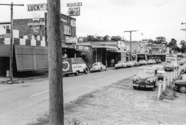
Photograph, Shopping centre, Main Road, Eltham, February 1968, Feb 1968
East side Main Road shops from Luck Street to Dudley Street. Includes Browne's Self Service, Milk Bar, Delicatessen, Chemist, Mac's Meats, Thompson's Pharmacy, N.H. Baxter Estate Agent.In February 1968 an unknown person took a series of photos from the Eltham Hotel at Pitt Street heading north along Main Road through the shopping centre to just north of Elsa Court covering the length of the section of Main Road which was duplicated shortly thereafter. Shows the condition and environment of the streesscape of Main Road, Eltham immediately prior to the duplication between Pitt Street and Elsa Court through the shopping centre. Also shows a number of shops and businesses that operated at that time.Black and white photographduplication, eltham, main road, browne's self service, dudley street, milk bar, delicatessen, chemist, mac's meats, thompson's pharmacy, n.h. baxter estate agent -
 Eltham District Historical Society Inc
Photograph, North end of the railway station carpark, Eltham, February 1968, Feb 1968
Shows the street sign for Luck Street intersection with Main Road.In February 1968 an unknown person took a series of photos from the Eltham Hotel at Pitt Street heading north along Main Road through the shopping centre to just north of Elsa Court covering the length of the section of Main Road which was duplicated shortly thereafter. Shows the condition and environment of the streesscape of Main Road, Eltham immediately prior to the duplication between Pitt Street and Elsa Court through the shopping centre. Also shows a number of shops and businesses that operated at that time.Black and white photographduplication, eltham, main road, carparks, luck street, railway station -
 Eltham District Historical Society Inc
Photograph, Looking south across to the shopping centre from the west side of Main Road, Eltham, February 1968, Feb 1968
Shows Bryant Motors beside Railway Station.In February 1968 an unknown person took a series of photos from the Eltham Hotel at Pitt Street heading north along Main Road through the shopping centre to just north of Elsa Court covering the length of the section of Main Road which was duplicated shortly thereafter. Shows the condition and environment of the streesscape of Main Road, Eltham immediately prior to the duplication between Pitt Street and Elsa Court through the shopping centre. Also shows a number of shops and businesses that operated at that time.Black and white photographduplication, eltham, main road, luck street, bryant motors, buses -
 Eltham District Historical Society Inc
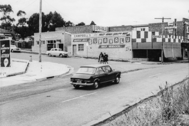
Photograph, Intersection of Main Road and Luck Street, Eltham, February 1968, Feb 1968
Shows the Supa-Value self-service shop with Campbell's Meats and the TAB. In February 1968 an unknown person took a series of photos from the Eltham Hotel at Pitt Street heading north along Main Road through the shopping centre to just north of Elsa Court covering the length of the section of Main Road which was duplicated shortly thereafter. Shows the condition and environment of the streesscape of Main Road, Eltham immediately prior to the duplication between Pitt Street and Elsa Court through the shopping centre. Also shows a number of shops and businesses that operated at that time.Black and white photographduplication, eltham, main road, luck street, caltex service station, campbell's meats, supa-value self service, tab -
 Eltham District Historical Society Inc
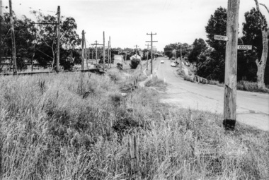
Photograph, Looking north along Main Road from Diamond Street Railway Crossing at intersection with Cecil Street, Eltham, February 1968, Feb 1968
Cecil Street to the right.In February 1968 an unknown person took a series of photos from the Eltham Hotel at Pitt Street heading north along Main Road through the shopping centre to just north of Elsa Court covering the length of the section of Main Road which was duplicated shortly thereafter. Shows the condition and environment of the streesscape of Main Road, Eltham immediately prior to the duplication between Pitt Street and Elsa Court through the shopping centre. Also shows a number of shops and businesses that operated at that time.Black and white photographduplication, eltham, main road, cecil street, diamond street, railway line -
 Eltham District Historical Society Inc
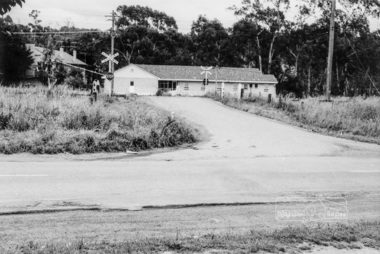
Photograph, Looking west across Main Road at the intersection with Diamond Street, Eltham, February 1968, Feb 1968
Shows an early Judge Book building and the Diamond Street railway crossing.In February 1968 an unknown person took a series of photos from the Eltham Hotel at Pitt Street heading north along Main Road through the shopping centre to just north of Elsa Court covering the length of the section of Main Road which was duplicated shortly thereafter. Shows the condition and environment of the streesscape of Main Road, Eltham immediately prior to the duplication between Pitt Street and Elsa Court through the shopping centre. Also shows a number of shops and businesses that operated at that time.Black and white photographduplication, eltham, main road, diamond street, railway line, railway crossing, judge book village -
 Eltham District Historical Society Inc
Photograph, Looking south along Main Road from Diamond Street Railway Crossing, Eltham, February 1968, Feb 1968
Luck Street enters Main Road from the left behind the Caltex garage. Note the house on right hand land.In February 1968 an unknown person took a series of photos from the Eltham Hotel at Pitt Street heading north along Main Road through the shopping centre to just north of Elsa Court covering the length of the section of Main Road which was duplicated shortly thereafter. Shows the condition and environment of the streesscape of Main Road, Eltham immediately prior to the duplication between Pitt Street and Elsa Court through the shopping centre. Also shows a number of shops and businesses that operated at that time.Black and white photographduplication, eltham, main road, diamond street, railway line, railway crossing, caltex service station, supa-value self service -
 Eltham District Historical Society Inc
Photograph, Looking east along Diamond Street to the railway crossing near intersection with Main Road, Eltham, February 1968, Feb 1968
Shows houses on Main Road and Cecil Street across Main Road from Diamond Street.In February 1968 an unknown person took a series of photos from the Eltham Hotel at Pitt Street heading north along Main Road through the shopping centre to just north of Elsa Court covering the length of the section of Main Road which was duplicated shortly thereafter. Shows the condition and environment of the streesscape of Main Road, Eltham immediately prior to the duplication between Pitt Street and Elsa Court through the shopping centre. Also shows a number of shops and businesses that operated at that time.Black and white photographduplication, eltham, main road, diamond street, railway line, railway crossing, cecil street, judge book village -
 Eltham District Historical Society Inc
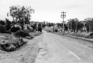
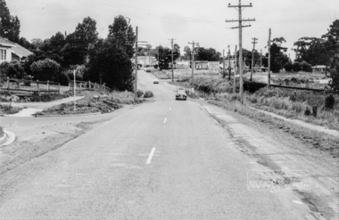
Photograph, Looking north along Main Road from intersection with Cecil Street, Eltham, February 1968, Feb 1968
In February 1968 an unknown person took a series of photos from the Eltham Hotel at Pitt Street heading north along Main Road through the shopping centre to just north of Elsa Court covering the length of the section of Main Road which was duplicated shortly thereafter. Shows the condition and environment of the streesscape of Main Road, Eltham immediately prior to the duplication between Pitt Street and Elsa Court through the shopping centre. Also shows a number of shops and businesses that operated at that time.Black and white photographduplication, eltham, main road, railway line, railway crossing, cecil street -
 Eltham District Historical Society Inc
Photograph, Looking southeast across Main Road to intersection with Cecil Street, Eltham, February 1968, Feb 1968
Shows street sign for Diamond Street on right with the railway crossing.In February 1968 an unknown person took a series of photos from the Eltham Hotel at Pitt Street heading north along Main Road through the shopping centre to just north of Elsa Court covering the length of the section of Main Road which was duplicated shortly thereafter. Shows the condition and environment of the streesscape of Main Road, Eltham immediately prior to the duplication between Pitt Street and Elsa Court through the shopping centre. Also shows a number of shops and businesses that operated at that time.Black and white photographduplication, eltham, main road, cecil street, diamond street -
 Eltham District Historical Society Inc
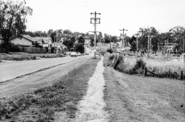
Photograph, Looking east across Main Road from just north of intersection with Diamond Street, Eltham, February 1968, Feb 1968
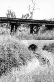
The watercourse passes under the road and railway at this point. Significant flash flooding occurred along this water course on Christmas Day 2011 causing significant damage to the railway line and road and flooding of Judge Book Village. In February 1968 an unknown person took a series of photos from the Eltham Hotel at Pitt Street heading north along Main Road through the shopping centre to just north of Elsa Court covering the length of the section of Main Road which was duplicated shortly thereafter. Shows the condition and environment of the streesscape of Main Road, Eltham immediately prior to the duplication between Pitt Street and Elsa Court through the shopping centre. Also shows a number of shops and businesses that operated at that time.Black and white photographduplication, eltham, main road, diamond street, bible street reserve, watercourse, drainage -
 Eltham District Historical Society Inc
Photograph, Looking west from Main Road from just north of intersection with Diamond Street, Eltham, February 1968, Feb 1968
The watercourse passes under the road and railway at this point. Significant flash flooding occurred along this water course on Christmas Day 2011 causing significant damage to the railway line and road and flooding of Judge Book Village. The drain was swept away including the support pillars of the rail lines timber framework. Judge Book Village had some 40 units flooded before the water entered Diamond Creek. The water had flowed down and flooded Valonia Drive then Grove Street before flowing down the watercourse to Main RoadIn February 1968 an unknown person took a series of photos from the Eltham Hotel at Pitt Street heading north along Main Road through the shopping centre to just north of Elsa Court covering the length of the section of Main Road which was duplicated shortly thereafter. Shows the condition and environment of the streesscape of Main Road, Eltham immediately prior to the duplication between Pitt Street and Elsa Court through the shopping centre. Also shows a number of shops and businesses that operated at that time.Black and white photographduplication, eltham, main road, diamond street, watercourse, drainage, railway line -
 Eltham District Historical Society Inc
Photograph, Looking south along Main Road towards the shops form near the intersection with Elsa Court, Eltham, February 1968, Feb 1968
In February 1968 an unknown person took a series of photos from the Eltham Hotel at Pitt Street heading north along Main Road through the shopping centre to just north of Elsa Court covering the length of the section of Main Road which was duplicated shortly thereafter. Shows the condition and environment of the streesscape of Main Road, Eltham immediately prior to the duplication between Pitt Street and Elsa Court through the shopping centre. Also shows a number of shops and businesses that operated at that time.Black and white photographduplication, eltham, main road, railway line, elsa court -
 Eltham District Historical Society Inc
Photograph, Looking east across Main Road towards Elsa Court, Eltham, February 1968, Feb 1968
In February 1968 an unknown person took a series of photos from the Eltham Hotel at Pitt Street heading north along Main Road through the shopping centre to just north of Elsa Court covering the length of the section of Main Road which was duplicated shortly thereafter. Shows the condition and environment of the streesscape of Main Road, Eltham immediately prior to the duplication between Pitt Street and Elsa Court through the shopping centre. Also shows a number of shops and businesses that operated at that time.Black and white photographduplication, eltham, main road, elsa court -
 Eltham District Historical Society Inc
Photograph, Looking south along Main Road from the intersection with Elsa Court, Eltham, February 1968, Feb 1968
In February 1968 an unknown person took a series of photos from the Eltham Hotel at Pitt Street heading north along Main Road through the shopping centre to just north of Elsa Court covering the length of the section of Main Road which was duplicated shortly thereafter. Shows the condition and environment of the streesscape of Main Road, Eltham immediately prior to the duplication between Pitt Street and Elsa Court through the shopping centre. Also shows a number of shops and businesses that operated at that time.Black and white photographduplication, eltham, main road, elsa court, railway line -
 Eltham District Historical Society Inc
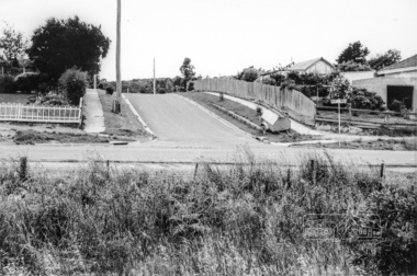
Photograph, Looking south along Main Road from just north of Elsa Court, Eltham, February 1968, Feb 1968
Shows where the future duplication of Main Road ends just north of Elsa Court.In February 1968 an unknown person took a series of photos from the Eltham Hotel at Pitt Street heading north along Main Road through the shopping centre to just north of Elsa Court covering the length of the section of Main Road which was duplicated shortly thereafter. Shows the condition and environment of the streesscape of Main Road, Eltham immediately prior to the duplication between Pitt Street and Elsa Court through the shopping centre. Also shows a number of shops and businesses that operated at that time.Black and white photographduplication, eltham, main road, elsa court, railway line -
 Eltham District Historical Society Inc
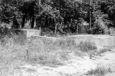
Photograph, Eltham, February 1968, Feb 1968
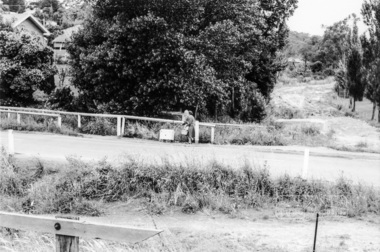
Location and significance not yet identified for this structure which was part of the series of 48 photos taken along Main Road, Eltham in February 1968In February 1968 an unknown person took a series of photos from the Eltham Hotel at Pitt Street heading north along Main Road through the shopping centre to just north of Elsa Court covering the length of the section of Main Road which was duplicated shortly thereafter. Shows the condition and environment of the streesscape of Main Road, Eltham immediately prior to the duplication between Pitt Street and Elsa Court through the shopping centre. Also shows a number of shops and businesses that operated at that time.Black and white photographduplication, eltham, main road -
 Eltham District Historical Society Inc
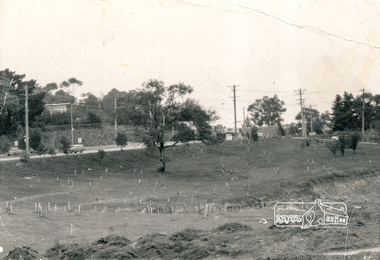
Photograph, Alistair Knox Park, Eltham, c.1970, 1970c
View from northwest corner showing survey pegs for trees and two ponds. Main Road has been duplicated. Bridge Street intersection showing the rock wall on the east side of the original Main Road (Maria Street). Burgoyne's Store and Eltham Uniting Church in distance at centre right and Our Lady Help of Christians at centre left.In February 1968 an unknown person took a series of photos from the Eltham Hotel at Pitt Street heading north along Main Road through the shopping centre to just north of Elsa Court covering the length of the section of Main Road which was duplicated shortly thereafter. Shows the condition and environment of the streesscape of Main Road, Eltham immediately prior to the duplication between Pitt Street and Elsa Court through the shopping centre. Also shows a number of shops and businesses that operated at that time.Black and white photographduplication, eltham, main road, bridge street, burgoyne's shop, eltham uniting church, our ladys church, maria street -
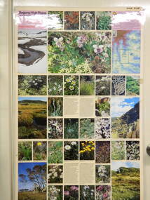 Kiewa Valley Historical Society
Map / Chart, Vegetation Map & Guide to Alpine Flora: Pretty Valley, 1982
This poster shows Pretty Valley is on the Victorian High Plains where the State Electricity Commission of Victoria worked on the Kiewa Hydro Scheme. Also cattle have grazed in the area over the years. This map is of interest to compare the flora in the area with times prior to 1982 and after 1982.This poster has historical and research value as it shows the flora in the pretty valley area therefore making it significant for people interested in plants. Also for those who would like to compare what plants are still in this area after 1982 and if the cattle grazing, climate change, of bush fires have had on the environment. Thus this poster also has good interpretive capacity of these reasons. Laminated double sided vegetation map and photographic guide to Alpine flora of the Pretty Valley areapretty valley. bogong. vegetation. plants. flowers. alpine. victorian high plains. cattle grazing. s.e.c.v. -
 Kiewa Valley Historical Society
Map / Chart, Vegetation Map & Guide to Alpine Flora: Hotham, 1982
This poster shows Mt Hotham is on the Victorian High Plains. This poster and map enables the comparison to be made of flora in other areas of the Victorian High Plains e.g.. which was previously known as the Bogong High Plains. This poster has historical and research value as it shows the flora in Mt Hotham area therefore making it significant for people interested in plants. Also for those who would like to compare what plants are still in this area after 1982 and if the cattle grazing, climate change, of bush fires have had on the environment. Thus this poster also has good interpretive capacity of these reasons.Laminated double sided vegetation map and photographic guide to Alpine flora of the Hotham area.hotham. vegetation. plants. flowers. alpine. high plains of victoria. -
 Kiewa Valley Historical Society
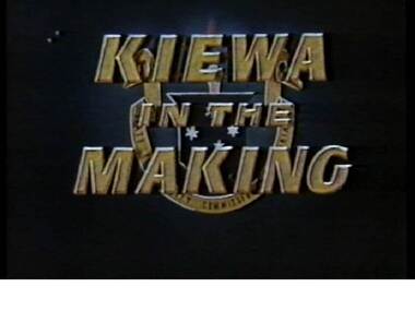
VHS Video - Kiewa, Kiewa Compile, Date compiled 25th Nov. 1998
The construction and development of the Kiewa Hydro scheme showing its construction and the people in work and play during its duration. It also shows the development of Mt Beauty and Bogong townships. The films were used as News Reels, Tourist Information and Entertainment.This item provids a snap shot in time (1990) when the Kiewa Valley was still relatively under populated and holiday houses owned by city bound workers was still relatively insignificant. As more and more holiday makers retire to a small but friendly region(Kiewa Valley and Mount Beauty) the increase in visitor numbers will affect the local rural bush scene more and more. The changes that will occur (in time) can be measured against the scenes presented in this video. The additional resources provided by the State Electricity Commission of Victoria of "alpine bush" fire control and management, together with an ongoing educational scheme for school children in learning about what constitutes the Alpine country's unique environment, are a very important offshoot, benefitting to both the communities within the Kiewa Valley and regional Victoria.This VHS tape is stored within its own plastic cover which has a front side Titled "KIEWA in the MAKING". The VHS tape is nestled within a formed inner structure which not only prevents the tape from moving to and fro but also unnecessary intrusion of foreign particles. Titled "Kiewa Compile" with 4 short films titled 1. Kiewa in the Making 2. Kiewa Capers 3. It only seems like yesterday 4. Kiewa.kiewa, hydro electricity, state electricity commission of victoria, construction towns, 1940s 1960s, mt beauty, bogong, falls creek, clover power station, mckay power station, bill sutton, news film, construction workers, early machinery -
 Kiewa Valley Historical Society
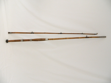
Rod Fishing, circa early 1900's
This bamboo fishing rod was used in the mid to late 1900's and demonstrates that local production of recreational fishing poles was at a high level and their demand was high. Imported recreational sporting goods from either the United Kingdom, the United States of America or Asia countries was due to the larger lead up times from these suppliers and the greater import costs from slower ocean supply ships. It was only after World War II that the trade influx from other countries has supplied cheaper goods. This recreational fishing pole is highly significant to the Kiewa Valley as it demonstrates that recreational fishing has been evolved from the need to supply a balanced diet by the early pioneer families of fish from the major Kiewa rivers. The ability of the Kiewa Valley rivers to provide a good fishing environment (high protein diet) for both early indigenous families and early pioneers was the important food source that provided for a balanced diet and the higher level of nutritious development of both body and mind. This two piece wooden fishing Rod is made from bamboo shafts or poles, one length thicker than the other. The smaller diameter shaft is the top end and fits into the longer thicker shaft at a stainless steel tube end.The smaller shaft has a stainless steel reinforcement ring where both shafts fit together. At the bottom end of the thick shaft is a black rubber "stopper" or "foot". There are two stainless steel rings, each with a reel holding "bulge" which allows for the the reel's "prongs" to be secured. The top ring has a greater diameter allowing it to move up and down the shaft/pole to secure the top "prong" firmly onto the shaft/pole.recreation, river, rod, fishing, industry, fish -
 Kiewa Valley Historical Society
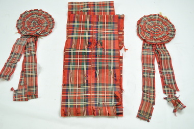
Sash and Rosettes Tartan
Early athletics year 11 school championships Kiewa Valley School Carnival circa 1920 - 1950s Historical and social significance of school based physical development of children through dedicated sports programs. An integral part of child development and socialising within the formal school environmentSash made from fine cotton weave with Scottish highland tartan. Width 12cm and sides fine stitched. Pattern (Royal Stewart) running length of ribbon.Two rosettes of same material 9cm diameter with three 3cm wide ribbons attached lengths 16cm, 20.5cm and 28cm The "Glen" designHighland clan to be identified sash, rosettes, school foot races -
 Kiewa Valley Historical Society
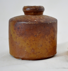
Ink Well
This inkwell was in use up until the early 1960's (especially in schools) and used as a source of ink into which a nib pen was inserted which could hold only a small amount for distribution onto mainly paper. The pen itself did not contain any "self" ink replenishment(such as fountain pens or later on biros ). Writing using this method involved a greater time period and also involved a drying application such as blotter to stop the ink from smudging(blurring or becoming smeared).This ink well is very significant to The Kiewa Valley because it represents a period before "cartridge" fountain pens and biros. It was in a "slower" paced era when written communication was not required to be an "instant" method. This was also a period in time when all forms of communication, especially in a rural settings, had no requirement, because of the facilities available, to be the "now" contingency. The "lay back" environment of semi isolated rural areas can be highlighted by the well used phrase of the times - "she'll be right mate"Brown coloured inkwell. Made of pottery, cylindrical shaped container with a raised neck opening at the top. This item has a flat bottom for positioning on a desk or other flat surfacepottery, inkwell for nib pens, stationery -
 Kiewa Valley Historical Society
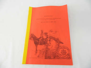
Book - Non Fiction History, Honour Roll - South Africa 1899 - 1902 Albury-Wodonga and District Residents Who Served In The Boer War, reprinted 03/2008
Historical information of soldiers from the Albury-Wodonga district who fought in the Boer War in South Africa 1899 - 1902. In 1996 the then curator for the 8/13 VMR Museum, the Hon Colonel John Neale, commissioned the author to research a group of returned servicemen and women from the Boer War and had lived within 100 km radius of the Albury/Wodonga townships.The Boer War was the second war in South Africa and was the result of heavy taxes and non voting rights of the local white Boer population. Colonial forces including the Australian Light Horse contingent where called upon by England to overthrow the rebellion. This War was the first engagement of Australian troops fighting on foreign soil.This Honour Roll details the pay rates, the battle highlights, weapons used and maps covering the first Australian contingent of soldiers who fought in the Transvaal (Boer War).. Listed are the names of those soldiers who lived within 100klms of Albury and Wodonga.The soldiers are listed by Location, Rank, Initial,Name and Unit. The significance of both the War and those who served in it is two fold. Firstly it demonstrates that the tie between the Colonial outreaches of England's Empire to "the Motherland" were extremely strong at this point in time. This union remained strong up until the middle of World War II when England could not help Australia to defend itself against possible invasion by Japan. The alliance between Australia and the United States of America replaced the British/Australian pact. Secondly the attitude of, and the high degree of horsemanship of those from the Albury and Wodonga area. The degree of adaptability, by these servicemen, to suit the environment in which they fought provided the first real insight into the Australian psyche "of those living and surviving on the harsh Australian outback"This book has a bright red soft cover and is bound with bright yellow tape. There is a drawing of two Australian soldiers on the front, one on horsebackAuthor's complimentary inscription "To Mount Beauty Museum with compliments" signed Ian R Docking history, boer war, ex-servicemen and women, albury and wodonga -
 Kiewa Valley Historical Society
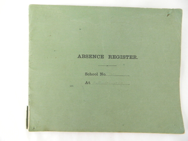
Register School Administration, Absence Register School No. 2539 Mullindolingong, circa 1910
Historical look (early 20th century) at the administrative requirements for the running of a small country school. The level of accountability was limited to a monthly report and a visit from the District Inspector. This was still in the era where paper reporting was utmost and faster electronic reporting had still to be implemented.The significance of this register is that it highlights the need in the early 1900s for travelling time, to and from, the duties required at a small country town to be detailed closely for a bureaucracy that was relatively isolated within the larger cities of Australia. Decentralisation of not only government but also of industry had not as yet entered the Australian environment. This register also shows that the written word was clearly hand scribed and thereby a more personal form of communication. This was still in the age where you " can tell a lot about a person from their handwriting" Lucy Goonan was Leonie Prime's relation and came from Glen Creek to teach at Mullindolingong School for a couple of years. None of the other names are 'known' names from the district.Green coloured cardboard backed book with two large staples holding each page at the left side of the spine Each page of has been folded in half from a 51cm overall length to produce each individual page of the register. This method of production of the book provides 25 double sided pages. Markings on cover " Absence Register, School No........ At ......." Markings on inside cover " ABSENCE REGISTER." Underneath this heading there are six explanatory and conditional usage. Each page is printed with the heading ABSENCE REGISTER and underneath "Roll No. 191(part of initial year reference), Record No. Name of Teacher Position Date of Absence Cause of Absence No. of times absent from beginning of year, total number of days absence and remarks requirements staff /reason/time taken during the period 1923 to 1950. Each page was printed with only three numbers of the calender year 191-.This was so that each year could be manually inserted.teachers absence register small school administration, mullindolingong school 1923 -1950 -
 Kiewa Valley Historical Society
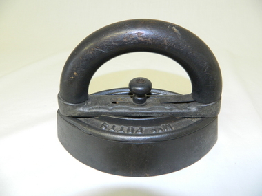
Iron - Flat, Circa early 1900s
Historically this item was used before the spirit and the electrical iron took over Circa 1930s -1950s. The main body of the iron was placed on a flat heated surface of a stove (wood, coal or gas fired). It was mainly used by women in their domestic role, ironing the family clothes and linen. In the Kiewa Valley the supply of coal or gas was not available or too expensive than the locally cut hard wood trees. This particular iron was an improvement on the fixed handled iron because it allowed (by use of its easily detachable handle) to use multiple bases and thereby allowing a constant heat supply to be maintained and not having to waste time for a base to reheat to the required level of application.The significance of this item was that it allowed for a faster method of ironing clothes and linen. It's invention was a progress towards reducing the time it took to undertake a very labour and intensive domestic function. The reduction of time taken for this household duty provided women great flexibility to undertake other activities. These type of improvements to basic domestic tasks liberated housewives not only physically but also mentally from the isolation of the home environment.This flat iron has a removable, clip-on handle. The handle and its release knob are of wood. The base of the handle together with the heavy flat body are made of cast iron. The body of the iron is oval shaped tapered at each end and is 40mm thick.Underneath the handle frame and on the main body, on one side, in raised lettering is "Mrs Potts" and on the other side "Iron". Both are clearly visible when viewed from an aerial position. Under removable handle and on a plate (screwed onto the main body) is "No 2"iron, antique, household, pressing clothes, domestic, laundry -
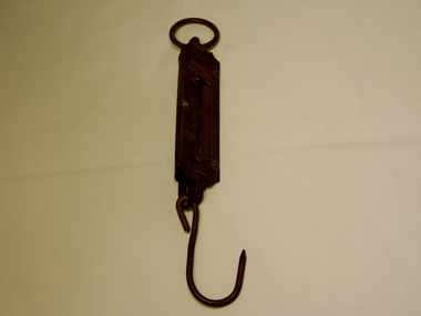 Kiewa Valley Historical Society
Scales Balance Pocket, Circa 1900
Historically this item would have been used by gold miners, rabbit shooters, mobile "Rag and Bone" traders and other mobile(in caravans and/or horse drawn cart) traders of various small goods and haberdashery. Although marked as not to be used as trade, the isolation and sometimes difficult terrain rules out using larger and more delicate scales. In the early 1900s rough roads and severe weather conditions forced traders to be more flexible in trading with weights and measures. The "close enough is good enough" doctrine was the Australian outback rule of thumb. The significance of this item in the Kiewa Valley during this period demonstrates the slower acceptance of accurate trading measure using the country side principle "my hand shake is my bond". In the Kiewa Valley small quantity commercial undertakings e.g. gold mining, fur pelts and rabbit meat trade did not require bulk weight type scales. Commerce in rural production e.g. fruit and vegetables involved more farmers and their staff in a barter and/or "in kind" payments. This was more so in the depression years 1929 to late 1930s. Self sufficiency was to a large extent more attainable in this region than in the city/ large country town environment. The Australian "fair go" ethical approach to life and commerce was very much ingrained in those living in country regions, like Kiewa Valley as is demonstrated by the not so accurate hand balance, spring loaded scales. Portable Pocket Balance with front plate made from brass. Spring mechanism enclosed by black painted medium gauge steel cover( three quarters cylindrical). Front scale face and rear spring casing fastened by three rivets. Spring loaded marker blade is located in the centre of the front plate. See item KVHS 0224 for a similar scales.Front plate marked: at top "Not legal for use in trade", below this in larger print "Pocket Balance", under and to the right in smaller print "lbs" under this graded marks, first marked with a Zero, then every second mark in ascending order up to 25. At the bottom of the front plate is marked "Made in Germany"antique pocket balance, scales, mobile weights, vintage appliances