Showing 2725 items
matching maps of goldfields
-
 Bendigo Historical Society Inc.
Map - CAMPBELL COLLECTION: BENDIGO AND DISTRICT MAPS
... Inc. History House 11 Mackenzie Street Bendigo goldfields MAP ...Map. Eppalock, Sedgwick and Strathfieldsaye, scale 20 chains to 1 inch. Road to Bendigo 13 1/2 miles at top right of map, Longlea Railway Station 5 1/2 miles, Bendigo 11 miles, Strathfieldsaye 5 miles on left of map. Total area 3972 acres. Prepared in W.P.B. from Assessment Plan and Parish Plans. H.A. Darby 14-6-29.H.A.Darbymap, bendigo, agricultural lands -
Bendigo Historical Society Inc.
Map - CAMPBELL COLLECTION: BENDIGO AND DISTRICT MAPS, 15-2-29
... Inc. History House 11 Mackenzie Street Bendigo goldfields MAP ...Map. Nerring, Parish of Nerring, scale 20 chains to 1 inch. Prepared in W.J.B. from A and B plans by W.J. Galbraith 15-2-29. (number 356 in map cupboard 1)W.J.Galbraithmap, bendigo, parish plan -
Bendigo Historical Society Inc.
Map - CAMPBELL COLLECTION: BENDIGO AND DISTRICT MAPS
... Inc. History House 11 Mackenzie Street Bendigo goldfields MAP ...Map. Ascot Unit, scale 20 chains to an inch, arrow pointing to magnetic north, road to Fosterville to the East, Huntly 3/4 mile to the West, road to Epsom 3/4 mile and road to Bendigo 4 1/2 miles south west on map, also on page is the Northern Railway (Bendigo to Echuca) line. (number 355 in map cupboard 1)map, bendigo, country lands -
Bendigo Historical Society Inc.
Map - CAMPBELL COLLECTION: BENDIGO AND DISTRICT MAPS
... Inc. History House 11 Mackenzie Street Bendigo goldfields MAP ...Map. Ellesmere, Parish of Ellesmere. Scale 20 chains to 1 inch. Total area 3926 acres. Prepared in W.P.B. from A and P plans. (number 354 in map cupboard 1)map, bendigo, agricultural lands -
Bendigo Historical Society Inc.
Map - CAMPBELL COLLECTION: BENDIGO AND DISTRICT MAPS, 8-2-29
... Inc. History House 11 Mackenzie Street Bendigo goldfields MAP ...Map. Bagshot, Parishes of Wellsford, Ellesmere and Bagshot. Scale 20 chains to 1 inch. Total area 5037 acres. Prepared in W.P.B. from A.C.l. and D.B. Plans, W.J. Galbraith, 8-2-29 (number 353 in map cupboard 1)W.J.Galbraithmap, bendigo, agricultural lands -
Bendigo Historical Society Inc.
Map - CAMPBELL COLLECTION: BENDIGO AND DISTRICT MAPS, 12-2-29
... Inc. History House 11 Mackenzie Street Bendigo goldfields MAP ...Map. Axedale, Parishes of Ellesmere and Axedale. Scale 20 chains to 1 inch. To the west is Wellsford. Total area 4156 acres. Prepared in W.P.B. from A and P plans by W.J. Galbraith 12-2-29. (number 352 in map cupboard 1)W.J.Galbraithmap, bendigo, agricultural lands -
Bendigo Historical Society Inc.
Map - CAMPBELL COLLECTION: BENDIGO AND DISTRICT MAPS, 1929
... Inc. History House 11 Mackenzie Street Bendigo goldfields MAP ...Map. Campaspe, Parish of Kimbolton. Total area 4117 acres. Campaspe River, Kimbolton. Scale 20 chains to 1 inch. Prepared in W.P.B. form Parish and Assessment Plans. G.W.L. 9-4-29. (number 351 in map cupboard 1)map, bendigo, allotments -
Bendigo Historical Society Inc.
Map - CAMPBELL COLLECTION: BENDIGO AND DISTRICT MAPS
... Inc. History House 11 Mackenzie Street Bendigo goldfields MAP ...Map. Whirrakee, Parish of Whirrakee. Total area of map 4419 acres. Scale 20 chains to 1 inch. 23 allotments are sold, Eucalypt oil distillery on lower portion of map. Prepared in W.P.B. from Assessor's plan and Parish Plan. (number 350 in map cupboard 1)map, bendigo, allotments -
Bendigo Historical Society Inc.
Map - CAMPBELL COLLECTION: BENDIGO AND DISTRICT MAPS
... Inc. History House 11 Mackenzie Street Bendigo goldfields MAP ...Map. Longlea, Parishes of Eppalock and Axedale. Scale 20 chains to 1 inch. Total area of map 2372 acres, with Bendigo 9 1/2 miles away. H.A. Darby 18-6-29. (number 349 in map cupboard 1)H.A Darbymap, bendigo, allotments -
Bendigo Historical Society Inc.
Map - CAMPBELL COLLECTION: BENDIGO AND DISTRICT MAPS
... Inc. History House 11 Mackenzie Street Bendigo goldfields MAP ...Map. Lyell, Parishes of Sedgwick, Eppalock and Lyell. Scale 20 chains to 1 inch. (number 348 in map cupboard 1)map, bendigo, agricultural lands -
Bendigo Historical Society Inc.
Map - CAMPBELL COLLECTION: BENDIGO AND DISTRICT MAPS
... Inc. History House 11 Mackenzie Street Bendigo goldfields MAP ...Map. Block plan key, Bendigo and surrounding districts including : Sandhurst, Nerring, Huntly, Neilborough, Salisbury, Yarrayne, Bridgewater, Yarraberb, Derby, Leichardt, Tarnagulla, Marong, Woodstock, Shelbourne, Lanecoorie, Lockwood, Ravenswood, Mandurang, Sedgwick, Kimbolton, Eppalock, Strathfieldsaye, Axedale, Wellsford, Ellesmere, Bagshot, Goornong, Nolan, Whirrakee, Egerton, Minto. (number 347 in map cupboard 1)map, bendigo, allotments -
 Bendigo Historical Society Inc.
Book - BENDIGO LANDSCAPE ASSESSMENT
Bendigo Landscape Assessment Big Hill & Mandurang Valley Drat Report 23 June 2012 contains maps and photographs.surveying, terrestial, mandurang valley -
 Bendigo Historical Society Inc.
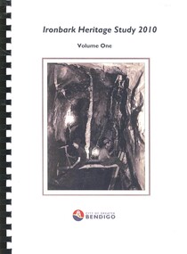
Book - IRONBARK HERITAGE STUDY
Ironbark Heritage Study 2010 Volume One & Two, contains maps and photographs of houses in area along with heritage reports and historical information. Prepared by Amanda Jean Architect and Heritage consultant for the City of Greater Bendigo.Amanda Jeanbendigo, buildings, heritage buildings -
 Bendigo Historical Society Inc.
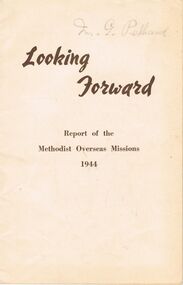
Document - LYDIA CHANCELLOR COLLECTION: ' LOOKING FORWARD.'
A white book titled 'Looking Forward : Report of the Methodist Overseas Missions 1944.' Sydney : Epworth Printing and Publishing House 218 Castlereagh Street. 1944. 22 pgs. 1 map. The name of Mr. G. Pethard is written on the front cover.religions, christian, methodist, lydia chancellor, collection, methodist church, uniting church, christianity, religions, overseas missions, charity -
 Bendigo Historical Society Inc.
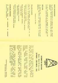
Document - BENDIGO CITY INFORMATION BROCURE BARKLY WARD, 23 March 1991
Bendigo City Information Brochure Barkly Ward By-Election. Saturday, 23rd March, 1991. Brochure by the Bendigo City Council to assist Barkly Ward residents in casting their vote in Barkly Ward, 23 March, 1991. Authorised by R J Burton, Returning Officer. Map of Barkly Ward. Candidate Information, Lois Angus, David Anderson, Lynne Geri. Ward Boundaries. Hotline. Polling places: Senior Citizens Centre (Bendigo), White Hills Primary School, Lake Weeroona Pavilion, North Bendigo Scout Hall. Disabled Persons all Polling Places are accessible to disabled persons in wheelchairs.government, local, barkly ward, bendigo city information brochure barkly ward by-election. saturday, 23rd march, 1991. 23 march, 1991. authorised by r j burton, returning officer. map of barkly ward. candidate information, lois angus, david anderson, lynne geri. ward boundaries. hotline. polling places: senior citizens centre (bendigo), white hills primary school, lake weeroona pavilion, north bendigo scout hall. all polling. accessible to disabled -
 Bendigo Historical Society Inc.
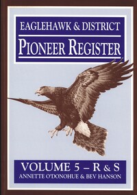
Book - EAGLEHAWK & DISTRICT PIONEER REGISTER VOLUME 5 R - S
Eaglehawk & District Pioneer Register Volume 5 R&S 1544 pages of information relating to Eaglehawk & district pioneers with black and white photographs and maps. Missing. Whereabouts unknown.Annette O'Donohue & Bev Hansonbook, bendigo, bendigo history & its people -
Bendigo Historical Society Inc.
Map - PLAN GENERAL SURVEY MALMSBURY PORCUPINE INN, FOREST CREEK TO GOLDEN POINT. ALEXANDRA RANGE 1853
... Inc. History House 11 Mackenzie Street Bendigo goldfields MAP ...Colour Copy of Plan of the General Survey from the Town of Malmsbury to the Porcupine Inn, from the sources of Forest Creek to Golden Point, shewing (sic) the Alexandrian Range also Sawpit Gully Bendigo and Bullock Creeks. Handwritten note under the title a follows '' Forwarded to the Colonial Secretary with my letter No A 53/105 dated 30th March 1853 for transmission to the Geological Surveyor. R Hoddle Surveyor General. ' Stamped by Department of Mines Victoria with record#123 in Top right Hand corner. Also contains a catalogue number 2053/M/2. Part of the Contents of a DVD entitled 'Mapping Great Change' - Archival Maps, produced to support an exhibition in the Post Office Gallery Bendigo. A description of the Map, its history and implications for both historical and future discussions is contained in an Essay 'Mapping Great Changes' : The landscape of central Victoria by Gerry Gill.R. Hoddlemap, bendigo, country lands -
Bendigo Historical Society Inc.
Map - VICTORIA HILL AREA
... Inc. History House 11 Mackenzie Street Bendigo goldfields MAP ...Contour plan of the Victoria Hill area, with all of the historical features marked and namedCompiled by AHQ Survey Regt. CMF increment May 1971map, reserves, mining, bendigo goldfield, victoria hill -
Bendigo Historical Society Inc.
Map - BENDIGO SHEET 2
... Inc. History House 11 Mackenzie Street Bendigo goldfields MAP ...Parish map showing the southern section of the City of Bendigo. It shows the city boundary running along Murphy Street, Grave (Patterson) Street, and the turns at the south end of Macdougall Road, the corner of Alder and Aspinal Streets and the corner near the Specimen Hill - Marong roads intersectionH.J. Green Govt. Printer, Melbournemap, bendigo, city streets, city of bendigo, parish map, city boundary -
 Bendigo Historical Society Inc.
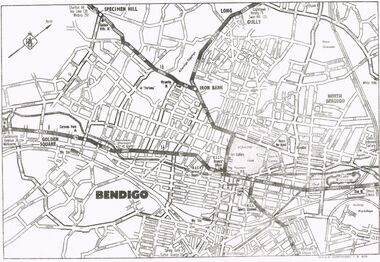
Map - MAP OF CENTRAL BENDIGO
... Inc. History House 11 Mackenzie Street Bendigo goldfields MAP ...Map of Central Bendigo, RACV Copyright (no date - but RACV Branch Office is shown as being at View Point). Black & White Copy. Showing road and rail system and prominent features of City landscape.RACV Copyright.map, bendigo, city streets, long gully, north bendigo, golden sqyare, specimen hill, iron bark. -
 Bendigo Historical Society Inc.
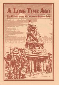
Document - A LONG TIME AGO: THE HISTORY OF THE MELBOURNE TO BENDIGO LINE
'A LONG TIME AGO: THE HISTORY OF THE MELBOURNE TO BENDIGO LINE' Bi-fold publication. A schematic 'strip' map of the line with particular places (approx 40) marked on the route with short descriptions of these sites. Concise description of the construction of the line; a summary of present attractions for the visitor to Bendigo and V/Line information.Walker Printing Bendigorailways, bendigo to melbourne, brochure, barkers creek , harcourt, elphinstone tunnel, malsmbury, malmsbury viaduct, kyneton, carlsruhe, hanging rock, woodend, mount macedon, riddells creek, clarkefield hotel, rupertswood, sunbury, diggers rest, sydenham, st albans, spencer street. v/line. -
 Bendigo Historical Society Inc.
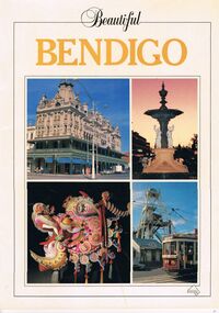
Book - PICTURES AND ATTRACTIONS OF BENDIGO: BEAUTIFUL BENDIGO
Booklet (18 pages) ''Beautiful Bendigo'' - coloured pictures of Bendigo and attractions with one page foreword. Published in association with the Bendigo and District Tourism Association, 1987. Includes city map at back of booklet.Printed in Singapore by Toppan Printing Company. Published by Robert Brown & Associated (Aust) Pty Ltd.bendigo, tourism, guide, tramways, george lansell, gold mines hotel, specimen cottage, queen elizabeth oval, secred heart cathedral, camp hill primary school, public library, conservatory gardens, school of mines. central deborah mine. dai gum san wax museum, kwan gung joss house, bendigo's sun loong dragon. sandhurst town, map of bendigo. -
 Bendigo Historical Society Inc.
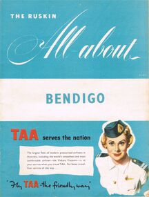
Book - BOOKLET: THE RUSKIN ALL-ABOUT
40 paged booklet - ''The Ruskin All-about'' (covering the Municipality of Bendigo facilities and activities), printed by The Ruskin Press, 1955. ''assisted by the Municipal Council and its officers and office-bearers of other organizations and associations''. Contents: Abbreviations; Baby Health Centres; Bus services; By-laws and regulations; Churches; Classified advertisers; Community activities; Doctors and surgery hours; Facts on the city; Friendly Societies; Hospitals; Magazine section; Maps; Message from the Mayor; Miscellaneous; Municipal services; The Municipality; Public and semi-public utilities; Schools and kindergartens; Sporting and recreation. Information on the forthcoming Olympic Games.Ruskin Publishing Pty. Ltd., 37 Swanston Street Melbourne.bendigo, tourism, guide -
 Bendigo Historical Society Inc.
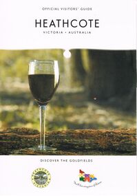
Book - HEATHCOTE: OFFICIAL VISITORS' GUIDE
Heathcote - Official Visitors' Guide. 18 page coloured booklet published by Heathcote Tourism and Development Inc. 2005. Attractions and activities in Heathcote area; accommodation options; dining. Includes map of township and nearby.Bart n Printvictoria, history, regional history., heathcote visitors guide -
 Bendigo Historical Society Inc.
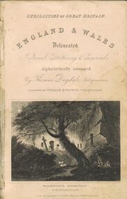
Book - 'DUGDALE'S ENGLAND AND WALES DELINEATED'
A damaged dark green hard covered book. On the spine it is titled, 'Dugdale's England and Wales delineated with maps & plates. Price 6s 6d. Vol. 1.' On the inside cover are the words, ' Curiosities of Great Britain. England & Wales Delineated, Historical, Entertaining & Commercial. Alphabetically arranged by Thomas Dugdale, Antiquarian, assisted by William Burnett, Civil Engineer.' Warkworth Hermitage, Northumberland. 164p. (ill.)Thomas Dugdalebooks, technical, geography, books, geography, history, curiosities, england, wales, united kingdom, reference -
 Bendigo Historical Society Inc.
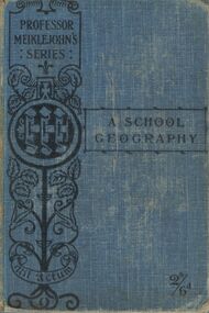
Book - A SCHOOL GEOGRAPHY
A blue hard covered book titled 'A School Geography with special reference to Commerce and History with maps and diagrams, by J.M.D. MeikleJohn M.A. and M.J.C. Meiklehohn, B.A.. New Edition. Corrected up to 1902. London. Alfred M. Holden 11 Paternoster Square, E.C., 1902. 415p. (ill.) On the front inside cover are the words ' R. D. Kelly 103 Wills. St., Bendigo.'J.M.D. Meiklehohn M.A. and M.J.C. Meiklehohn, B.A.books, school, geography, books, geography, school, texts, reference, climate, europe, commerce, history -
 Bendigo Historical Society Inc.
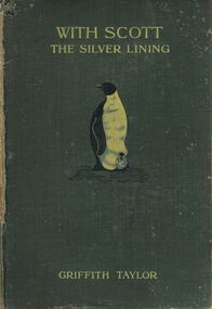
Book - WITH SCOTT: THE SILVER LINING
A damaged hard covered book titled 'With Scott : the Silver Lining.' by Griffith Taylor.'With nearly 200 illulstrations and maps.' An illustration of a penguin and chick is on the front cover. London. Smith, Elder & Co. publishers, 15 Waterloo Place. 1916. 448 p. (ill., maps,)Griffith Taylorbooks, biography, captain scott, books, exploration, adventure, antarctica, people, person, famous people, captain robert falcon scott -
 Bendigo Historical Society Inc.
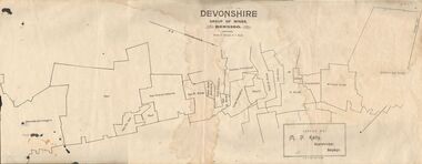
Map - DEVONSHIRE GROUP OF MINES BENDIGO
... Inc. History House 11 Mackenzie Street Bendigo goldfields MAP ...Map showing the mining leases that include the Devonshire group of mines - leases shown from north to south are: Catherine Reef United , William United, Ellenborough, Sadowa, St. Mungo, Lady Barkly, South St. Mungo, Phoenix, United Devonshire, Duchess of Edinburgh, New St. Mungo, South Devonshire, Extended South Devonshire, New Victoria Catherine, Pearl, Hercules and Energetic.Issued by M. P. Kelly, Sharebroker, Bendigomap, bendigo, goldfields, catherine reef united , williamd united, ellenborough, sadowa, st. mungo, lady barkly, south st. mungo, phoenix, united devonshire, duchess of edinburgh, new st. mungo, south devonshire, extended south devonshire, new victoria catherine, pearl, hercules and energetic. mining, gold mines -
 Bendigo Historical Society Inc.
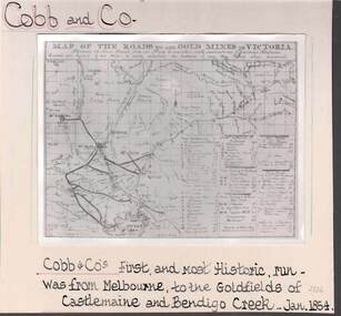
Photograph - COBB & CO,., MAP OF COACH RUN TO BENDIGO
black and white image ( copy ) on board : image shows map of roads to all gold mines in Victoria., showing Cobb & Co., routes. Written on board: Cobb and Co., Cobb & Co's first and most historic run was from Melbourne to the goldfields of Castlemaine and Bendigo Creek, Jan 1854./// image shows -'Map of the roads to all gold mines in Victoria., showing the Cross roads from one mine to another with indications of various stations divided into squares of ten miles to easily calculate the distance of any new mines when discovered ///There is a list of towns with their distance from Melbourne and to & from distances for other destinations Cobb & Co., routesbusiness, transport, cobb & co., cobb & co., bendigo, transport -
 Bendigo Historical Society Inc.
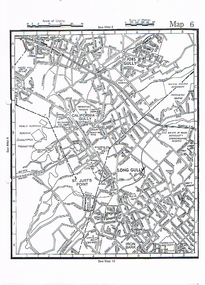
Map - LONG GULLY HISTORY GROUP COLLECTION: MAP OF LONG GULLY
Copy of a street map showing Jobs Gully, California Gully, Long Gully, St Just's Point and Iron Bark.bendigo, history, long gully history group, the long gully history group - map of long gully, jobs gully, california gully, long gully, st just's point, iron bark