Showing 11127 items
matching planning.
-
 Port Melbourne Historical & Preservation Society
Plan - Proposed extensions, Heath Street, Port Melbourne Town Hall, E J Pembroke, 15 Oct 1936
Floor plans, elevations to Heath street; south end; roof plan for proposed extensions to supper room Town Hall 1936. Coloured plans."City of Port Melbourne . Proposed Extensions to Supper Room . Town Hall"port melbourne town hall, pembroke and turner, e j pembroke -
 Kew Historical Society Inc
Booklet, Sands & McDougall, Rules and Regulations, Boroondara General Cemetery, 1911
The 31-acre (13 ha) cemetery site was reserved in 1855 and trustees were first appointed in 1858. A site plan was drawn up by Frederick Acheson, a civil engineer in the Public Lands Office, with the layout segregated by religious denomination, a common occurrence at the time. The first burial took place in 1859. The rules were gazetted rather than published as guidelines as the cemetery was constituted under and act of parliament. Early publication about the Boroondara General Cemetery which, in addition to providing public guidelines, reflects the social and spiritual values of the period.Rules and regulations of the Boroondara General Cemetery. Published in by Sands & McDougall Ltd, Collins St. Gazetted 10th November, 1893. 24pp. The booklet includes a plan of the cemetery.rules and regulations -- cemeteries -- victoria, boroondara general (kew) cemetery -
 Kew Historical Society Inc
Plan - Subdivision Plan, Corsewall Estate, 1938
The Kew Historical Society collection includes almost 100 subdivision plans pertaining to suburbs of the City of Melbourne. Most of these are of Kew, Kew East or Studley Park, although a smaller number are plans of Camberwell, Deepdene, Balwyn and Hawthorn. It is believed that the majority of the plans were gifted to the Society by persons connected with the real estate firm - J. R. Mathers and McMillan, 136 Cotham Road, Kew. The Plans in the collection are rarely in pristine form, being working plans on which the agent would write notes and record lots sold and the prices of these. The subdivision plans are historically significant examples of the growth of urban Melbourne from the beginning of the 20th Century up until the 1980s. A number of the plans are double-sided and often include a photograph on the reverse. A number of the latter are by noted photographers such as J.E. Barnes.The Corsewall Estate was a subdivision, bordering on Barkers Road and Auburn Road, which created Corsewall Close. This relatively late subdivision included 29 allotments. The subdivision plan includes the dimensions of each lot as well as the width of the existing and projected roads and turning circles. The Corsewall Close Precinct is now listed on the Victorian Heritage Database (HO147) and is noted for its ‘consistent flat-type development over the entire street, which has been cleverly designed to make multi-unit dwellings appear as single buildings’.subdivision plans - hawthorn, corsewall estate -- hawthorn (vic.) -
 Melbourne Legacy
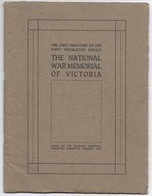
Booklet, The First Brochure on the First Premiated Design. The National War Memorial of Victoria, 1928
A booklet produced by Hudson and Wardrop, Architects, who had won the contest for the design of the Shrine. This booklet shows their models of the Shrine in photos and diagrams of the site. It goes into detail of the plans for Rock of Remembrance, the eye of light, the porticos, the tympanums, the inner Shine, and materials it will use, etc. It says: 'The theme is Remembrance, and the doing is indicative of Remembrance. It is Australian in feeling, in that is stands for the highest of Australian ideals - ideals we fought for - Patriotism, Sacrifice, Justice and Freedom.' Messrs Hudson and Wardrop were also returned servicemen. This booklet could have been used to inform the public of the plans whilst fundraising for the building project. In 1928 the Governor asked for the public to contribute approx £100,000 towards the project, while the State Government had already guaranteed £80,000. (Actual budget ended up being £250,000). Item was in an envelope with other photos and programmes from different items relating to the Shrine of Remembrance - including discussions on its location and design. Labelled 'Shrine of Remembrance S1 - S14' it was part of an old archive numbering system, that showed there has been efforts in the past to collect, order and save items of Legacy's history. (01181 - 01190, 01206 - 01211, 01649, 01650).A record of the planning for the Shrine of Remembrance with details from the architects who had won the design contest. There was an effort to record historical events for the "Archive Committee" which collected this and other documents relating to the Shrine together in a file (see items 01181 - 01190, 01206 - 01211, 01649, 01650).Booklet x 20 pages, describing plans for the Shrine, buff paper in a dark grey brown cover with black and white photos and black print.memorial, shrine of remembrance -
 Federation University Historical Collection
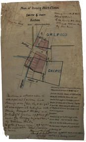
Plan, Plan of Smith & Party's Quartz Block Claim, Redan, 27/10/1884
Hand drawn plan for smith and Party's quartz block plan in Redan, Ballarat.smith and party, redan, quartz block claim, mining, darling street, skipton street, cobden street, robert davidson, plans, cgt -
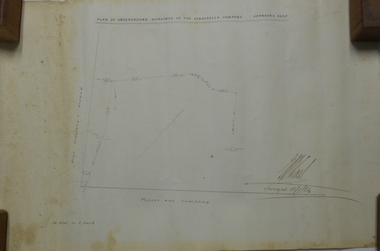
Port Melbourne Historical & Preservation Society
Plan - Lyons Street, Port Melbourne, Borough of Sandridge, 9 Oct 1877
Plan of Lyons Street, showing longitudinal section, ground plan and transverse section.Minehan, Michael:Clark, Edward C (Town Clerk)engineering - roads streets lanes and footpaths, michael minahan, edward clark, town clerks -
 Melbourne Tram Museum
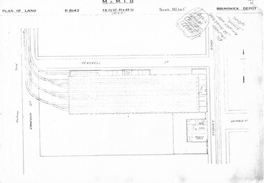
Drawing, Melbourne & Metropolitan Tramways Board (MMTB), "Brunswick Depot", c1937
Set of three photocopied plans or drawings on A3 sheet of Brunswick Depot - dated 30-6-1937 .1 - P8142 - Plan showing depot block and building plan .2 - P8144 - Detail plan of depot .3 - P8146 - Plan of Mess Room above depot offices / basement.trams, tramways, drawings, depots, property, brunswick depot -
 Bendigo Historical Society Inc.
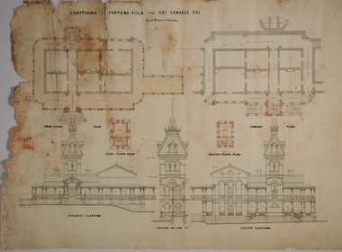
Plan - MARKS COLLECTION: PLAN FOR FOUR LEVEL STAIRCASE TOWER TO GARDEN ELEVATION AT FORTUINA VILLA FOR GEO. LANSELL ESQ
Fortuna Villa was owned from 1855 to 1871 by Christopher and Theodore Ballerstedt, Australia’s first mining magnates. In 1871 it was purchased by George Lansell (The Quartz King) being one of Australia’s most successful and adventurous nineteenth century gold mine owners and speculators. Lansell made numerous alterations and extensions to the building and it remained in the Lansell family until 1935.Plan for four level staircase tower to the Garden Elevation of Fortuna Villa, Sandhurst for George Lansell Esq. Plan details: * Plan shows ground, First, second and third floor plans for the staircase construction * First and second floor house plans and location of staircase addition * Front and Garden elevations with staircase addition Plan coloured and damaged on LHS, also with water damagebendigo fortuna villa, george lansell, building plans, c & t ballerstedt -
Federation University Historical Collection
Plan, Crown Lands Department Melbourne, Parish of Clarkesdale, County of Grenville
Geolgical plan.clarkesdake, berringa, staffordshire reef, piggoreet -
 RMIT Design Archives
Architectural drawings, Proposed Family Residence for Mr. & Mrs. Spedding at Lot 2 Bolton Avenue, Brighton
Sketh plansink, acetate -
University of Melbourne, Burnley Campus Archives
Plan - Sketch, Widening road for parking. Buildings in College area occupied by other branches, c. 1950
Sketch plan.burnley school of horticulture, roads -
University of Melbourne, Burnley Campus Archives
Plan, Science Bench, c. 1960
Plan No. 3.science -
Friends of Ballarat Botanical Gardens History Group
Plan - Concept Design The Fernery Ballarat Botanic Gardens, Andrew Laidlow, August 2014
Photocopy of Planballarat botanical gardens, fernery, concept design, fernery layout -
Port Melbourne Historical & Preservation Society
Map - MMBW, c. 1894
Melbourne and Metropolitan Board of Works Plan No. 323,330, 335, 336 Segments shown: As Plan No. Large scale plan of lagoon fill area (40'=1")engineering - board of works, sandridge lagoon, transport - tramways, engineering - canals and drainage, built environment, gasworks, business and traders - hotels -
University of Melbourne, Burnley Campus Archives
Plan - Photocopy, Percy Everett, New School of Primary Agriculture & Horticulture - Burnley Gardens, 1945
Floor plans and elevations of new building designed by Percy Everett, Chief Architect, Public Works DepartmentPhotocopies, reduced in size, of Original Plans for the Administrative Building. Signed, Percy Everett, Chief Architect, Dept of Public Works, Victoria, dated 26.09.1945 (1) UCB.2.135 Ground Floor and First Floor. (2) UCB.2.136 Transverse Section, Longitudinal Section. N.B. University of Melbourne - Property and Services has a better copy.buildings, percy everett -
 Bacchus Marsh & District Historical Society
Map, Bacchus Marsh Suburban Allotments Parwan Road Lodge & Dunn's Paddocks 1888
This map was created as a plan for an auction of land close to the Bacchus Marsh Railway Station. The auction took place on 23 October 1888. 102 allotments of land from an area known as Lodge and Dunn's paddocks was offered for sale. A single page paper map showing allotments of land for sale along the Parwan Road in Maddingley. The map is pasted into a bound volume containing 76 maps or plans in total. High resolution digital image stored on BMDHS computer network. land sales bacchus marsh, land sales maddingley, bacchus marsh victoria maps, maddingley victoria maps -
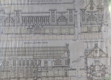 Federation University Historical Collection
Plan - Architectural Plans, Australian Natives' Association Ballarat Branch No 4 Architectural Plans
Percy Richards taught Architecture and Building Construction at The Ballarat Art School - a division of Ballarat School of Mines from 1918-1921. He was responsible for the design of a number of buildings in the district. This item is the "Specification of work required to be done and materiaals required for construction of the new A.N.A. Building at the corner of Sturt, Albert and Lewis Streets, Ballarat. Prepared by and to the satisfaction of P.S. Richards, A.R.V.I.A. Architect and subject to the General Conditions of Contract." "BALLARAT CITY A.N.A. BALLARAT, Wednesday — The Ballarat City branch, A.N.A., which was formed nearly 50 years ago, ranks fourth on the association records, but several of the members were prominent in establishing the association in Melbourne a year or two earlier. On the past half-year's operations the total funds increased by £1558/18/3 to £29.389/11/11. The membership now totals 949. The committee recommended that as the property at the corner of Sturt and Albert Streets, which had been intended as the site of a new hall, had been sold, steps should he taken to remodel the present hall, and bring It up to date. The report was adopted." (The Herald, 18 June 1924)Fourteen detailed drawings showing the specifications for each section of the new A.N.A. building for Ballarat. A 24 page document submitted to the Public Health Department, Victoria, received 15 January 1918 and a 3 page document related to Reinforced Concrete Particulars. All contained in a labelled black metal cylinder.A.N.A.4. PLANS painted on side and lid. Signature of P.S. Richards.ana, australian natives' association, architecture, percy richards, building specifications, ballarat, technical art school ballarat, materials, construction, p.s. richards, percival selwyn richards -
Moorabbin Air Museum
Book (item) - CAC Collection - Technical Data Bell Helicopter Company
Electromagnetic Compatibility Test Plan For Australian Army 206B-1 Helicopter -
Moorabbin Air Museum
Book (item) - CAC Collection - Technical Data Bell Helicopter Company
Electromagnetic Compatibility Control Plan For The Australian Army 206B-1 Helicopter -
 Dutch Australian Heritage Centre Victoria
Road Map, Nederland
Cleverly folded 1:250,000 road map produced in Dutch, French, German and English containing not only the Dutch road network but also much information of interest to tourists. It is enclosed in a brown imitation leather cover that closes with a stud. Optimal ease of use through patented Falk folding mode.Falk Plan. Road Map. Netherlands. Repeated in Dutch, French and German. -
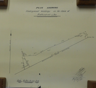 Bendigo Historical Society Inc.
Document - MARKS COLLECTION: UNDERGROUND WORKINGS BALLERSTED & SON
Plan on white paper (copy) of underground workings. On top of plan 'Plan Showing Underground Workings in the claim of Ballerstedt & Son' On bottom date written 29/11/65. Plan shows lease peg, southern boundary of claim.bendigo, mining, ballerstedt & co -
 Bendigo Historical Society Inc.
Plan - MARKS COLLECTION: PLAN OF UNDERGROUND WORKINGS CINDERELLA COMPANY, JOHNSON'S REEF
Plan on heavy parchment paper: on top of plan 'Plan of the underground workings Cinderella Company, Johnson's Reef' Lh side of plan 'Kent Company's Ground' on bottom: Tipper and Company. Written on bottom surveyed 13/7/64.bendigo, mining, cinderella company -
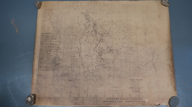 Kiewa Valley Historical Society
Map - Kiewa Scheme General Plan
Existing and possible future roads are numbered and named 1 - 45. The plan is based on an aerial photos taken March 1945. It includes revisions up to 1951. Signed by H.H.C. Williams, construction engineer. Mountains, rivers, roads and SECV places are named, also SECV infrastructure and construction eg. workers camps, Power stations.Significant for the information re the Kiewa Hydro Electric Scheme's development.Yellowed paper with brown print. Kiewa Scheme general plan showing its development. A lot of information is recorded. Note: Dyeline print was used which causes fading when exposed to light. Handwritten: 'Bob Duncan'bob duncan, kiewa hydro electric scheme, secv, khes development -
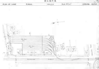 Melbourne Tram Museum
Drawing, Melbourne & Metropolitan Tramways Board (MMTB), "Coburg Depot", c1937
Set of two photocopied plans or drawings on A3 sheet of Coburg Depot - c1937 .1 - P8343 - Plan showing depot block and building plan with adjacent private houses and properties .2 - P8344 - Detail plan of depot - with notes about possible plans and changes - 4/1967. shows substation location.trams, tramways, drawings, depots, property, coburg depot, substation -
Port Melbourne Historical & Preservation Society
Plan - Unnamed Street, c. 1893
Plan for "unnamed street" (later Edwards, Morley) Loan Works 1893, plan no. 11 engineering - roads streets lanes and footpaths -
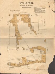 Bendigo Historical Society Inc.
Map - JACK FLYNN COLLECTION: WELLSFORD, 15/12/1941
Map: Parish of Wellsford, County of Bendigo. Parish plan. 2 copies of the same plan.map, bendigo, parish plan, wellsford -
Whitehorse Historical Society Inc.
Map, Eastern Freeway Extension, 2002
Extension of Eastern Freeway: Plan of Deep Creek Road paths, drainage and alignment plan.Extension of Eastern Freeway: Plan of Deep Creek Road paths, drainage and alignment plan.Extension of Eastern Freeway: Plan of Deep Creek Road paths, drainage and alignment plan.deep creek road, mitcham, eastern freeway extension, eastlink -
University of Melbourne, Burnley Campus Archives
Plan - Photocopy, Proposed Reserve for Horticultural and Experimental Garden in the Survey Paddock Richmond, 1862-1948
Photocopy of Plan Gazetted 01.08.1863. From Central Plan Office Department of Natural Resources.Original signed by Clement Hodgkinson, Deputy Surveyor General. Stamped Department of Lands and Survey 7.12.48 Neg.18377. Handwritten notes on back "Melb Roll 23, R.19(A)"burnley, horticultural and experimental garden, survey paddock, richmond, clement hodgkinson -
Whitehorse Historical Society Inc.
Article, East Burwood Tram Line, 27/05/1992 12:00:00 AM
The $6.5 million stage 1 extension to East Burwood tramline will start next month.The $6.5 million stage 1 extension to East Burwood tramline will start next month. The extension will be from Middleborough to Blackburn Road and the track construction will begin February 1993. The initial plan is to extend right to Knox City. Construction will be by a combination of VicRoads, MET and private contractors.The $6.5 million stage 1 extension to East Burwood tramline will start next month. tram services, victoria. ministry of transport, vicroads, met, burwood east -
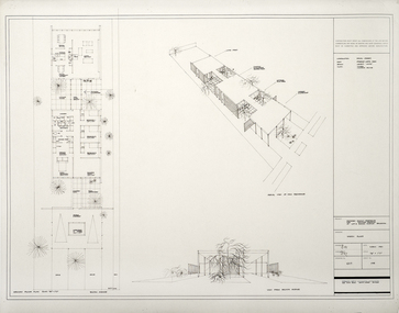
Port Melbourne Historical & Preservation Society
Plan - Floor Plans, Proposed Port Melbourne Library, Fred Cook, City Engineer, 1938
From set of plans for the proposed Library - City of Port Melbourne 1938 4 sheets with ground floor plan, roof plan, 1st floor plan, side elevation, elevation. Two on paper, hand coloured; two on tracing paper."City of Port Melbourne Proposed Library":Fred Cook City Engineerbuilt environment - civic, city engineers, fred cook, port melbourne library