Showing 25582 items matching "plenty-township-estate"
-
 Greensborough Historical Society
Photograph - Digital Image, Old Pool Plenty River 2014, 21/05/2014
Plenty River pool Greensborough. Opened in 1937, the remnants of this concrete pool can be seen today from the Main Street bridge Greensborough. Photograph by Marilyn Smith 2014.Digital copy of colour photograph.plenty river pool, swimming pools, greensborough pool -
 Greensborough Historical Society
Photograph - Digital Image, Old Pool Plenty River May 2014, 21/05/2014
Plenty River pool Greensborough. Opened in 1937, the remnants of this concrete pool can be seen today from the Main Street bridge Greensborough. Photograph by Marilyn Smith 2014.Digital copy of colour photograph.greensborough pool, swimming pools, plenty river pool -
 Eltham District Historical Society Inc
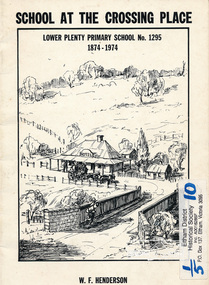
Book, School at the crossing place : Lower Plenty Primary School no. 1295, 1874-1974 / W.F. Henderson, 1974c
23 pages including information on inside covers. Text with black and white illustrations and photographs and map. Contents: Crossing Place Need for a school Residence for the teacher Closure A View of Lower Plenty 1918 Moving day at the Village The Golf Club Depression 1931 Vandals Electricity Grass Fires Cows at School Mothers' Club Women's liberation 1950's Lower Plenty after 1945 Swimming Pool - drowned dreams Long Grass - snakes - meadow hay - Fire Brigade The Royal Visit 1954 School Band Community Centre Our School Hall Trees and Gardens The Library Education 1874-1974 A Teacher's View The Second generation - children of ex-pupils (photo with names) The Third generation - Grandchildren of ex-pupils (photo with names) Head Teachers (list with dates) The Staff 1974 (photo with names) The sketch on the cover shows the Lower Plenty Bridge, toll house and the Plenty Bridge hotel, both no longer there. The bridge is listed in the Banyule Heritage Study and has recently been restored by Banyule Council as a pedestrian bridge - NL 137 March 2001 Paperback; [24] p. : ill. ; 25 cm.lower plenty, state school no. 1295, lower plenty primary school -
 Greensborough Historical Society
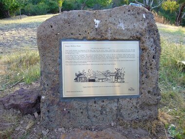
Photograph - Digital Image, Happy Hollow plaque, 05/02/1840o
The land surrounding Happy Hollow farm at Plenty was purchased by Francis Wickham in 1840. The land was later subdivided and held by various owners including Charles Partington (1875) and John McLaughlin who leased the property in 1892 to Robert Emmett Whatmough who erected the first dwelling on the property. The land was later owned by Mrs Betty Bell and was purchased by Parks Victoria in 1994 to form part of the Plenty Gorge Parklands. This plaque was laid by Plenty Historical Society.Happy Hollow was an example of early settlement along the Plenty River.Digital copy of colour photograph. Plaque at Plenty Gorge Parklands.plenty river, happy hollow, happy hollow farm, robert emmett whatmough, betty bell, john mclaughlin, charles partington, parks victoria -
 Ringwood and District Historical Society
Photograph, Panfield Estate, Ringwood - 1960. Looking across to Mullum Rd. with Glen Cairn Ave. at right-angle to it. House at left is in Graeme Street, Ringwood
Written on backing sheet, "Panfield Estate 1960. Looking across to Mullum Rd. with Glen Cairn Ave. at right-angle to it. House at left is in Graeme St." -
 Greensborough Historical Society
Photograph - Digital image, Main Road Lower Plenty 1928, 1928_
122 Main Road Lower Plenty, built by Stan Barnett 1928. Photographs from the collection of Peter Blackbourn, a descendant of the Chapman Stock family. Annotations to photos by Peter Blackbourn.Digital copy of black and white photograph.peter blackbourn, stan barnett, 122 main road lower plenty -
 Greensborough Historical Society
Photograph - Digital image, Lower Plenty Sunday School circa 1936-38, 1936-1938
Children at Lower Plenty Sunday School; the teacher came from Heidelberg. Photographs from the collection of Peter Blackbourn, a descendant of the Chapman Stock family. Annotations to photos by Peter Blackbourn.Digital copy of black and white photograph.peter blackbourn, lower plenty sunday school -
 Greensborough Historical Society
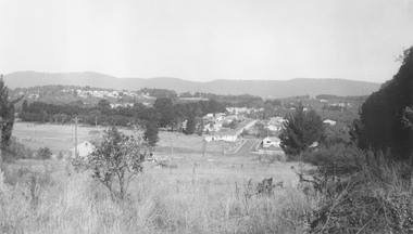
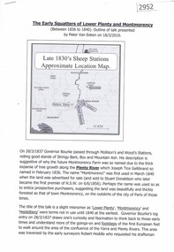
Article, Peter van Eeken, The Early squatters of Lower Plenty and Montmorency between 1836 to 1840, by Peter van Eeken, 1836-1840
Talk given by Peter van Eeken to a general meeting of the Greensborough Historical Society on 18 March 2016. The topic is the early squatters of Lower Plenty and Montmorency from 1836 to 1840.4p., text and illus.lower plenty, montmorency, edward willis, james willis -
 Kew Historical Society Inc
Plan - Subdivision Plan, Jas R Mathers Son & McMillan, Macartney Estate, East Kew, c. 1925
Pru Sanderson, in her groundbreaking ‘City of Kew Urban Conservation Study : Volume 2 - Development History’ (1988), summarised the periods of urban development and subdivisions of land in Kew. The periods that she identified included 1845-1880, 1880-1893, 1893-1921, 1921-1933, 1933-1943, and Post-War Development. These periods were selected as they represented periods of rapid growth or decline in urban development. An obvious starting point for Sanderson’s groupings involved population growth and the associated economic cycles. These cycles also highlighted urban expansion onto land that was predominantly rural, although in other cases it represented the decline and breakup of large estates. A number of the plans in the Kew Historical Society’s collection can also be found in other collections, such as those of the State Library of Victoria and the Boroondara Library Service. A number are however unique to the collection.Subdivision plans are historically important documents used as evidence of the growth of suburbs in Australia. They frequently provide information about when the land was sold on which a built structure was subsequently constructed as well as evidence relating to surveyors and real estate and financial agents. The numerous subdivision plans in the Kew Historical Society's collection represent working documents, ranging from the initial sketches made in planning a subdivision to printed plans on which auctioneers or agents listed the prices for which individual lots were sold. In a number of cases, the reverse of a subdivision plan in the collection includes a photograph of a house that was also for sale by the agent. These photographs provide significant heritage information relating house design and decoration, fencing and household gardens.The Macartney Estate subdivision advertised 21 lots for sale on either side of Macartney Street (now Macartney Avenue) and Evans Road in what was then designated as East Kew. Most of the houses shown on the south side of Macartney Street then, as now, have rear entrances on Mount Street, however a number of these blocks have since been further subdivided to allow for the building of new houses on the rear of a block. Brougham Place is marked on the plan but is now called Daniell Place."C"subdivision plans - east kew, macartney estate, macartney street, mount street, evans road, brougham place -
 Ringwood and District Historical Society
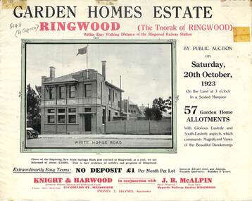
Flyer, Subdivisional Land Auction Sale Brochure, Garden Homes Estate, Ringwood, Vic. - 1923
Double sided multi-folded page advertising auction sale of residential allotments highlighting local facilities, services and layout of the estate. Includes panoramic view of Ringwood and other local photographic images.Subdivision includes Mullum Mullum Road, The Centreway, Wattle Crescent and Reserve Crescent. Agents - Knight & Harwood, 315 Collins Street, Melbourne, Phone 10615, 10616 Central, in conjunction with J.B. McAlpin, Opposite Railway Station, Ringwood. Phone Ringwood 7. -
 Ringwood and District Historical Society
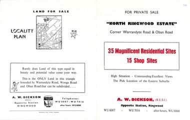
Flyer, Land Sale Brochure, North Ringwood Estate, Ringwood, Vic. - 1958
Double-sided land sale advertisement for sale of 35 residential and 15 shop sites on the corner of Warrandyte Road and Oban Road, Ringwood North, Vic., including locality plan and features of the estate.Subdivision includes Oban Road, Warrandyte Road, and Dickson Crescent. Agent: A.W. Dickson, Opposite Station, Ringwood. (Phone) WU6007, WU7016, after hours WU6868. -
 Whitehorse Historical Society Inc.
Document, Heatherdale Road Estate, 1921
Purchasers' copy of 'Particulars and Conditions and Contracts of Sale for Heatherdale Road Estate, Lot 168, sold to Mr Frederick Baldwin of Gre Gre via St Arnaud, farmer, 12 March 1921.heatherdale road estate, mitcham, baldwin, frederick, brady, john f, land sales -
 Whitehorse Historical Society Inc.
Pamphlet, Hill 60 Estate, 13/04/1957 12:00:00 AM
Auction of 64 homes sites in the last section of Hill 60 Estate to be auctioned by Frank Fisher & Co. on 13 Apr 1957.Auction of 64 homes sites in the last section of Hill 60 Estate to be auctioned by Frank Fisher & Co. on 13 Apr 1957. There is also a Drake & Co. Pty Ltd sticker on page 4.Auction of 64 homes sites in the last section of Hill 60 Estate to be auctioned by Frank Fisher & Co. on 13 Apr 1957. hill 60 estate, forest hill, hill 60 estate, tunstall, frank fisher co., drake co. -
 Kilmore Historical Society
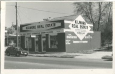
Photograph, Kilmore Real Estate, 1970's?
The building is not demolished and new tenants occupy the space (PHO-00011). Present day (2020) the building is occupied by a tobacconist. 14cm x 9cm black and white photograph of the building on 5 Sydney Street, which at the time of the photograph was Kilmore Real Estate. There is one car parked on the street and the gantry of the neighbouring property is visible.Inscribed on back: 5 Syd 106real estate agents -
 Ringwood and District Historical Society
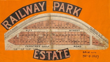
Flyer, Subdivision sale poster - Railway Park Estate, Ringwood, Victoria - 1887
Collage of clipped lettering and map pasted to orange coloured card depicting Railway Park Estate subdivision sale. Handwritten names associated with allotments and notation of sale date - 30 November, 1887. Subdivision plan with pink shading highlighting 73 allotments in Ferntree Gully Road (later Bedford Road) and Pitt Street, Ringwood. Handwritten names associated with allotments include Arthur Wiseman, T. Grant, J.J. Miller, M. Dickson, G.G. Miller, J. Frost, J.K. Turnbul, J.W. Davis, William Aldridge. Additional hand-drawn map on cardboard backing labeled Allotments for Sale at Ringwood - Part of Crown Allotment 17. -
 Greensborough Historical Society
Photograph - Digital image, Lower Plenty State School 1934 LP1295, 1934_
Lower Plenty Primary School 1934. (left to right) Back row: unknown, Ivy Barnett,unknown, Kathy Barnett, unknown. Front row: unknown, Dorothy Kenny, unknown, unknown.Digital copy of black and white photograph.peter blackbourn, lower plenty primary school, ivy barnett, kathy barnett, dorothy kenny -
 Greensborough Historical Society
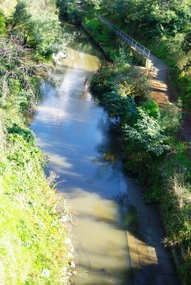
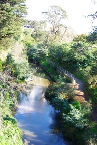
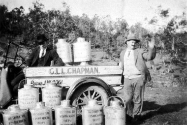
Photograph - Digital image, Plenty River Fishermen, 1920c
Plenty River fishermen. Two men with truck and barrels of fish, truck has sign - G.L.L. Chapman House Renovator Northcote. Barrels printed with Return to Fisheries Department Melbourne [or Ballarat]. Digital copy of black and white photograph.plenty river -
 Greensborough Historical Society
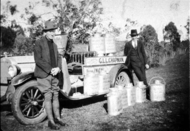
Photograph - Digital image, Plenty River Fishermen, 1920c
Plenty River fishermen. Two men with truck and barrels of fish, truck has sign - G.L.L. Chapman House Renovator Northcote. Barrels printed with Return to Fisheries Department Melbourne [or Ballarat].Digital copy of black and white photograph.plenty river -
 Greensborough Historical Society
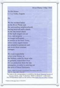
Document, Petition from 'Ladies resident on Plenty River', 05/05/1842
Copy of text of the Petition to the Governor of Victoria, C. J. La Trobe, from 'Ladies resident on Plenty River' requesting protection from bushrangers, 5 May 1842, with list of petitioners.Indicates dangers of living in the remote location of Plenty River in 1842 and lists women living in the area.2p. col. printed 2 sidesplenty river, bushrangers, petitions -
 Greensborough Historical Society
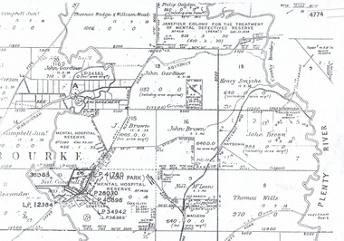
Maps, Greensborough west of Plenty River, 1840o
Areas of Greensborough, west of the Plenty River, showing land holdings in the 1840s. Comprises Sections 8, 9, 10, 14, 15, 16, 17, 18, 19, 20 Parish of KeelbundoraOne A4 photocopy, one A3 enlargementgreensborough, watsonia, lower plenty, janefield -
 City of Moorabbin Historical Society (Operating the Box Cottage Museum)
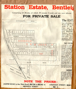
Flyer - Station Estate, Bentleigh
At the end of World War One, there was a renewed interest in residential land and a number of estates opened up in the Municipality of Moorabbin.Example of the progress of the Municipality of MoorabbinAdvertising flyer for private sale of real estate sales - plan of building blocks for saleStation Estate, Bentleigh, for private sale 20 blocks unsold.atkinson street, ardwick street, ethel street, jasper road, bentleigh, real estate, auction -
 Halls Gap & Grampians Historical Society
Map - Coloured
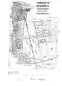
Map showing layout for township of HeatherlieTownship of Heatherlie; Parish of Boroka; County of Borung; scale measurement; R.O. Robson Authorised surveyormaps, heatherlie township -
 Kew Historical Society Inc
Plan - Subdivision Plan, Mont Victor Hill Estate, 1936
Pru Sanderson, in her groundbreaking ‘City of Kew Urban Conservation Study : Volume 2 - Development History’ (1988), summarised the periods of urban development and subdivisions of land in Kew. The periods that she identified included 1845-1880, 1880-1893, 1893-1921, 1921-1933, 1933-1943, and Post-War Development. These periods were selected as they represented periods of rapid growth or decline in urban development. An obvious starting point for Sanderson’s groupings involved population growth and the associated economic cycles. These cycles also highlighted urban expansion onto land that was predominantly rural, although in other cases it represented the decline and breakup of large estates. A number of the plans in the Kew Historical Society’s collection can also be found in other collections, such as those of the State Library of Victoria and the Boroondara Library Service. A number are however unique to the collection.Subdivision plans are historically important documents used as evidence of the growth of suburbs in Australia. They frequently provide information about when the land was sold on which a built structure was subsequently constructed as well as evidence relating to surveyors and real estate and financial agents. The numerous subdivision plans in the Kew Historical Society's collection represent working documents, ranging from the initial sketches made in planning a subdivision to printed plans on which auctioneers or agents listed the prices for which individual lots were sold. In a number of cases, the reverse of a subdivision plan in the collection includes a photograph of a house that was also for sale by the agent. These photographs provide significant heritage information relating house design and decoration, fencing and household gardens.A preliminary plan for the Mont Victor Hill subdivision of 1936 which included 23 allotments bordering the Rimington Nursery in Mont Victor Road. The subdivision created allotments in Victor Avenue, Heather Grove and Burke Road. Bisecting the Estate and clearly marked on the plan is the Railway Reserve which at this stage was all that remained of the Outer Circle Railway. The auctioneers note on the plan that the subdivision was made possible by the order of Messrs S. H. Bennet & H. Wright, the executors of the Wills of S. Bennett & E. Foreman.mont victor hill estate, subdivision plans - kew -
 Kew Historical Society Inc
Plan - Subdivision Plan, Warne Estate, Undated
Pru Sanderson, in her groundbreaking ‘City of Kew Urban Conservation Study : Volume 2 - Development History’ (1988), summarised the periods of urban development and subdivisions of land in Kew. The periods that she identified included 1845-1880, 1880-1893, 1893-1921, 1921-1933, 1933-1943, and Post-War Development. These periods were selected as they represented periods of rapid growth or decline in urban development. An obvious starting point for Sanderson’s groupings involved population growth and the associated economic cycles. These cycles also highlighted urban expansion onto land that was predominantly rural, although in other cases it represented the decline and breakup of large estates. A number of the plans in the Kew Historical Society’s collection can also be found in other collections, such as those of the State Library of Victoria and the Boroondara Library Service. A number are however unique to the collection.The Kew Historical Society collection includes almost 100 subdivision plans pertaining to suburbs of the City of Melbourne. Most of these are of Kew, Kew East or Studley Park, although a smaller number are plans of Camberwell, Deepdene, Balwyn and Hawthorn. It is believed that the majority of the plans were gifted to the Society by persons connected with the real estate firm - J. R. Mathers and McMillan, 136 Cotham Road, Kew. The Plans in the collection are rarely in pristine form, being working plans on which the agent would write notes and record lots sold and the prices of these. The subdivision plans are historically significant examples of the growth of urban Melbourne from the beginning of the 20th Century up until the 1980s. A number of the plans are double-sided and often include a photograph on the reverse. A number of the latter are by noted photographers such as J.E. Barnes.The Warne Estate included four lots in Argyle Street, Kew. It represents a typical small-scale subdivision in this area. The lots for sale must have been further divided as there are now more houses in the street than there were blocks advertised in the subdivision. The agent left the proximity of the Outer Circle Railway off the plan. The Railway would have run along the triangular shaped lot 4. Lot 4 was offered for the sum of £600 plus the costs of footpath construction.subdivision plans - kew, warne estate -
 Greensborough Historical Society
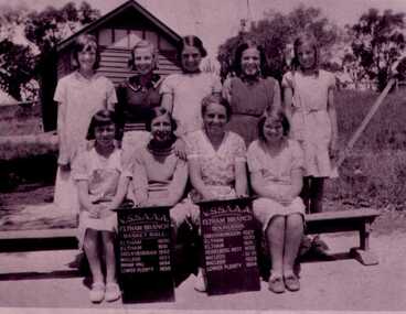
Photograph - Digital image, Plenty Tennis 1935, 1935_
Photograph of a function at Plenty Tennis Club 1935. Myrtle McLaughlin is on far right. Part of a collection of photographs owned by Myrtle McLaughlin who was born in Greensborough to John McLaughlin and Rosalie Ellen Whatmough. Digital copy of black and white photograph.plenty tennis club, myrtle mclaughlin -
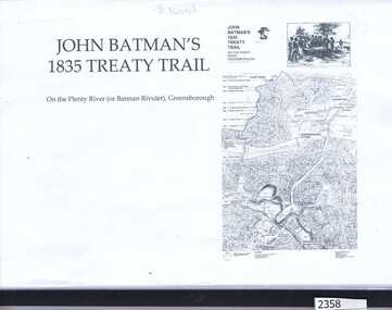 Greensborough Historical Society
Folder, Dennis Ward, John Batman's 1835 Treaty Trail: on the Plenty River (or Batman's Rivulet), Greensborough / by Dennis Ward, 06/06/1835
This information was collected for a grant application to erect signage along the Plenty River path, outlining the history of this area where early settlement of the area occurred. The application was made by GHS member Dennis Ward.Black spiral bound folder with clear cover containing 18 pages of photograph and text.plenty river trail, plenty river, willis vale, dennis ward -
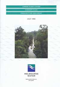 Greensborough Historical Society
Book, Lower Plenty River concept plan: prescription document, 1992_07
Draft concept plan prepared. by Brett Cheatley, Malcolm Warren and Ian Womersley, Parks and Waterways Planning Division, Melbourne Water. Includes management areas and key strategies for the Lower Plenty River.Book, mainly black and white print, colour photographs and plans, 66 pages. 3 copiesplenty river, melbourne water, lower plenty river -
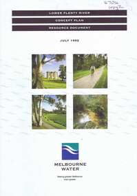 Greensborough Historical Society
Book, Lower Plenty River concept plan: resource document, 1992_07
Draft concept plan prepared by Brett Cheatley, Malcolm Warren and Ian Womersley, Parks and Waterways Planning Division, Melbourne Water. This document includes information on the heritage and environment of the Lower Plenty River.Book, mainly black and white, colour photographs and plans, 56 pages, 3 copies.plenty river, melbourne water, lower plenty river -
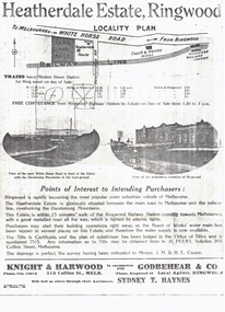 Whitehorse Historical Society Inc.
Document, Heatherdale Estate, Ringwood, 1919
Brochure advertising 52 lots, Heatherdale Estate, Ringwood (now Mitcham) to be auctioned September 1919.Brochure advertising 52 lots, Heatherdale Estate, Ringwood (now Mitcham) to be auctioned September 1919. Station Street on the plan is now Victory Street and a Railway Avenue is shown which does not now exist.Brochure advertising 52 lots, Heatherdale Estate, Ringwood (now Mitcham) to be auctioned September 1919.land subdivision, heatherdale estate, whitehorse road, mitcham, melbourne and metropolitan board of works, peers, w.h., coane, j.m., h.e., knight & harwood, godbehear & co, haynes, sydney t, walter street, witt street, victory street, purches, frederick walter -
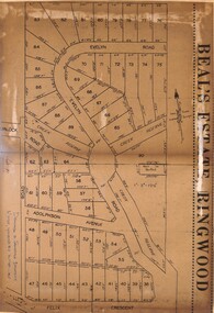 Ringwood and District Historical Society
Document - Folder, Beale's Estate Subdivision, Ringwood, Victoria - circa 1960
Manilla folder containing two undated maps of Beale's Estate subdivision 20559 showing allotments on Evelyn Road, Burlock Road (later Burlock Avenue), Adolphson Avenue, and Felix Crescent, North Ringwood.