Showing 11716 items matching "r "
-
 Federation University Historical Collection
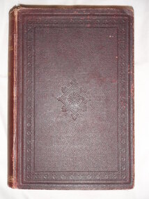
Book, W. & R. Chambers, Treatise on Practical Mathematics, 1883, 1883
Brown hardcovered book of 536 pages.Stamped inside front cover "Presented to the School of Mines, Ballarat by Professor A. Mica Smith, 1926."mathematics, alfred mica smith -
 Federation University Historical Collection
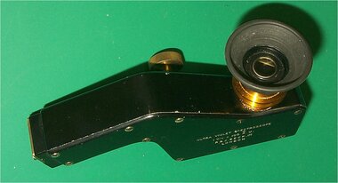
Instrument - Scientific Instrument, R. & J. Beck Ltd, Ultra-Violet Spectroscope
A fluorescent screen seen with an illuminated scale shows the wavelength(s) of entering light. A Cylindrical Quartz Lens is provided to concentrate on the slit light from weak sources. The scale is illuminated by regular white light through a window. Ultra Violet Spectroscope. A black finished device with adjustable aperture in a storage box with eyepiece shield and clamping screw. scientific instrument, balance, spectoscope, ultra violet spectroscope, prism -
 Federation University Historical Collection
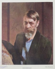
Book, The Shepherd Press, The Science of Appearances as Formulated and Taught by Max Meldrum, 1950
This book could be described as the summing up of a theory of physical appearances, devised by a painter and demonstrated by paint. The foundation of this theory was laid down first in Paris by Max Meldrum early 1900s. A review calls the book "the most outstanding book on the craft of painting yet published in any language. Max Meldrum was born in Edinburgh, Scotland on 03 December 1875. His family arrived in Australia and Max Meldrum attended the National Gallery School, winning the Victorian Travelling Scholarship in 1899. It was deaccessioned and transferred from the Ballarat School of Mines library so would have been used by students and staff of the Ballarat Technical Art School, a division of the Ballarat School of Mines. Red fabric hard covered book of 298pp, includes colour plates that have been pasted into the book. The book inlcudes 11 colour prints and 11 line and tone diagrams. These diagrams in clude Major and Minor Dark and liLight Disturbances; Speed Values and Form; Complex Light Disturbance; Experiments in Definition and Inclination; Apparatus for the Analysus of Visual Phenomena by Distance; Set of Patches; Modern and Obsolete Methods of Approach, Tonal Analysis on "St John's Parad"'; Chromatic Analysis of "St John's Parade". This book was part of the Ballarat Technical Art School LibraryA review has been pasted in the front..max meldrum school, max meldrum, art, science of appearances, appearances, color plates, tonalism, ballarat school of mines library, ballarat technical art school -
 Federation University Historical Collection
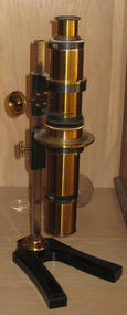
Scientific Instrument, Calderon's Stauroscope, c1900 (?)
The stauroscope is an instrument for studying characteristic properties of anisotropic mineral particles. Later petrografic microscopes incorporate the stauroscope feature. Calderon Stauroscope in a hinged timber box. An optical device resembling a microscope with a vertical axes. The composite tube is made of brass, and is adjustabbly attached to a splayed-leg base equipped with a traingula section pillar. Instrument and accessoried housed in a brown polished timber box stauroscope, scientific instrument, microscope -
Federation University Historical Collection
Book, R. Kirke Rose, The Metallurgy of Gold, 1898, 1898
T. Kirke Rose was an Associate of the Royal School o fMines, an Fellow of the Chemical Society amd ASsistant Assayer of the Royal Mint.Red hard covered, indexed book of 528 pages, with numerous illustrationsInside front :To Alfred John Hill with all good wished for a successful career from Alf Mica Smith Daniel Walker School of Mines Ballarat June 1900alfred mica smith, daniel walker, alfred john hill, mining, metallurgy, alloys, gold, cyanides, shallow deposits, water, quartz crushing, stamp battery, chilian mill, stanford's feeder, mercury, screens, concentration, hartz jigs, percusion tanle, roastin, butters mill, kennel, california, pyritic smelting -
 Federation University Historical Collection
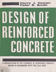
Book, Halstead Press, Design of Reinforced Concrete, 1963, 1963
Hardcovered book with green, white and black dust Jacket. Includes receipt made out to the user, Brian Schreenan (engineer).concrete, reinforced concrete, sellers plate, robertson & mullens sellers plate, bookseller place -
 Federation University Historical Collection
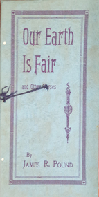
Booklet, James R. Pound, Our Earth Is Fair and Other Verses, 1931
Blue soft covered booklet of verses.non-fictionjames pound, verses, poetry -
Federation University Historical Collection
Book, W. & R. Chambers, Silver Bells, 1952
Mary Egan who died on April 4th, 1981, spent 23 years as a greatly-respected lecturer in English curriculum at the Ballarat Teachers College, State College of Victoria and Ballarat College of Advanced Education. Orange and blue covered 48 page book of poems for use in the teaching of reading Book Plate, M.Egan on sticker on front cover that some one has tried to remove.mary egan, ballarat teachers college, state college of victoria, ballarat college of advanced education, education department victoria, a. stamp, t.c. collocott, l.m dufty, w & r chambers, t and a. constable -
 Federation University Historical Collection
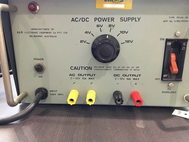
Electrical Equipment, AC/DC Power Supply Unit - Rectifier
What device converts AC to DC? rectifier A rectifier is an electrical device that converts alternating current (AC), which periodically reverses direction, to direct current (DC), which flows in only one direction. The process is known as rectification, since it "straightens" the direction of current. The unit was used at Ballarat School of Mines in the Maths, Science and Physics Departments.Grey metal unit with Dials on the front and vents at the back. Handle for carrying. Two switches for turning on and off. Yellow sticker - SMB - with number 116071. Engraved on back - S.M.B.. Maths / Science / Physics Sticker on cord indicating inspection of unit - 13/04/2005. Tag Number - 032735alternating current, direct current, ac, dc, rectifier, electrical, ballarat school of mines, science, maths, physics -
 City of Moorabbin Historical Society (Operating the Box Cottage Museum)
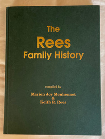
Book - Family History, Menhennet, Marion Joy et al, The Rees Family History, 1991
Index: non-fictionrees, family history -
 City of Moorabbin Historical Society (Operating the Box Cottage Museum)
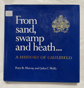
Book, Murray, Peter R. et al, From sand, swamp and heath : a history of Caulfield, 1980
278p. : ill., graphs, maps, portrs. includes index.non-fictioncaulfield history, caulfield council -
Port Melbourne Historical & Preservation Society
Certificate, R F Steel, Baptist Union of Victoria. Diploma of attendance, 1919 - 1921
Baptist Union of Victoria. Diploma of attendance. Awarded by the Sunday School Committee. Awarded to Percy A MAY 1919-1921"Percy A May" hand written, signed by W H Holdsworth and M Burgen. Three stamps at the bottom awarding for attendance for 1919, 1920 and 1921awards and presentations, religion - baptist church, education, percy allan may, w h holdsworth, m burgens -
Port Melbourne Historical & Preservation Society
Map - Road plans for Fishermens Bend, R S Atkinson, 30 Apr 1946
CRB Map outlining road plans for Fishermens Bend and including the site of the Commonwealth Aircraft Corporation, Aerodrome, General Holdens and C.S.R.I., 1946transport - aviation and aerodrome, industry - manufacturing, fishermans bend -
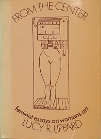 Women's Art Register
Book, Lucy R. Lippard, From the Centre. Feminist essays on women's art, 1976
Following an introduction from the editors of Art-Rite are 12 essays by Judy Chicago discussing feminist art history, academic perspectives, contested issues, projects and exhibitions, and 18 monographs on specific artists, plus two fictional pieces.Booknon-fictionFollowing an introduction from the editors of Art-Rite are 12 essays by Judy Chicago discussing feminist art history, academic perspectives, contested issues, projects and exhibitions, and 18 monographs on specific artists, plus two fictional pieces.art history, criticism, gender, contemporary, feminism, joan mitchell, judy chicago, faith ringgold, louise bourgeois, adrian piper, eva hesse, performance -
Port Melbourne Historical & Preservation Society
Document - Leaflet, W R Porteous re new gum moistener for envelopes, W R Porteous, 1890s
Leaflet from W.R. Porteous, specialities agent, advertising the new patent gum moistener for envelopes. From Great Britain. Attached is business card (506.02)business and traders, w r porteous -
Port Melbourne Historical & Preservation Society
Card - Business card, W R Porteous, W R Porteous, 1890s
Business card of W.R. Porteous, specialities agent, 31 Queen Street, Melbourne. Attached to leaflet (506.02)business and traders, w r porteous -
Port Melbourne Historical & Preservation Society
Document - Notice, Land auction, Williamstown Road to Plummer Street, Port Melbourne, R Holden Stone, Borough Surveyor Brighton and Port Melbourne, Mar 1887
Large auction notice advertising sale of land Williamstown Road to Plummer Street 19.3.1887, with general (distorted) plan of Port Melborne and a larger plan of the allotmentstown planning, fishermans bend, land sales -
Port Melbourne Historical & Preservation Society
Plan, B A Carter, Land Plan Primary School 1427 Port Melb, c. 1975
The design for extensive planting and landscaping of Nott Street Primary School, Port MelbournePlan of Landscape design for Nott Street Primary School, Port Melbourne.education - primary schools, nott street primary school -
 Port Melbourne Historical & Preservation Society
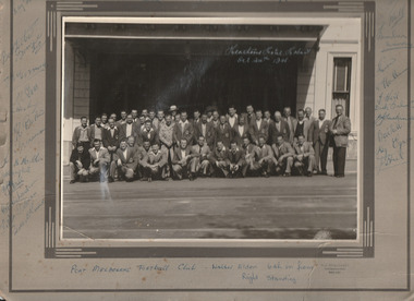
Photograph - Port Melbourne Football Club 1948, R J Hellessy, 24 Oct 1948
Players & officials on post season trip to Tasmania. Only person identified is Walter ELDEN - standing 6th from right. Signatures include: Reg EGAN; Bomber MURRAY; T HALL; S HALL; Sid SEARL; ? REYNOLDS; G BENNETT; Des BAKER; N GOSS; H BAKER; B MILLER.B & w photograph of three rows of Port Melbourne Football Club players and officials in front of Heathorns Hotel, Liverpool Street Hobart.Heathorns Hotel, Hobart Oct 24th 1048 written on photograph. Club members' signatures on mount.sport - australian rules football, port melbourne football club, reg egan, bomber murreay, t hall, s hall, sid searl, ? reynolds, g bennett, des baker, norm goss snr, h baker, b miller -
 Monbulk RSL Sub Branch
Book, Salvationist Publishing, Campaigning in captivity, 1947
The story of members of the Salvation Army in captivity during World War IIp.102.non-fictionThe story of members of the Salvation Army in captivity during World War IIsalvation army - history, world war 2 - prisoners of war -
 Monbulk RSL Sub Branch
Book, Michael J H Taylor et al, Missiles of the world, 1976
Alphabetic listing of various missile types from different nationsIndex, ill (b/w), p.156.non-fictionAlphabetic listing of various missile types from different nationsguided missiles, military technology -
 Monbulk RSL Sub Branch
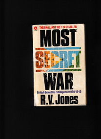
Book, Coronet, Most secret war, 1979
Reginald Jones was nothing less than a genius. And his appointment to the Intelligence Section of Britain's Air Ministry in 1939 led to some of the most astonishing scientific and technological breakthroughs of the Second World War. In Most Secret War he details how Britain stealthily stole the war from under the Germans' noses by outsmarting their intelligence at every turn. He tells of the 'battle of the beams'; detecting and defeating flying bombs; using chaff to confuse radar; and many other ingenious ideas and devices. Jones was the man with the plan to save Britain and his story makes for riveting reading.Index, notes, ill, maps, plans, p.702.non-fictionReginald Jones was nothing less than a genius. And his appointment to the Intelligence Section of Britain's Air Ministry in 1939 led to some of the most astonishing scientific and technological breakthroughs of the Second World War. In Most Secret War he details how Britain stealthily stole the war from under the Germans' noses by outsmarting their intelligence at every turn. He tells of the 'battle of the beams'; detecting and defeating flying bombs; using chaff to confuse radar; and many other ingenious ideas and devices. Jones was the man with the plan to save Britain and his story makes for riveting reading. world war 1939 – 1945 – secret service – britain, world war 1939 – 1945 – science and technology -
 Monbulk RSL Sub Branch
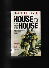
Book, Pocket Books et al, House to house : an epic memoir of war, 2008
Ill, p.320.non-fictioniraq war - personal narratives, iraq war - battle of fallujah -
 Monbulk RSL Sub Branch
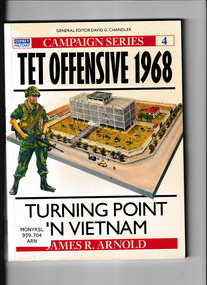
Book, Osprey, Tet offensive; 1968 : the turning point in Vietnam, 1990
This book describes the Tet offensive by Viet Cong forces. An event seen as a turning point ion American involvement in VietnamIll, maps, p.96.non-fictionThis book describes the Tet offensive by Viet Cong forces. An event seen as a turning point ion American involvement in Vietnamvietnam war 1961-1975 – history, vietnam war 1961-1975 – tet offensive -
 Monbulk RSL Sub Branch
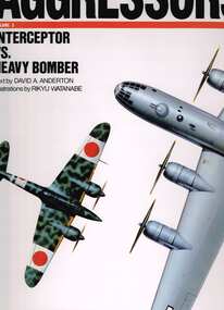
Book, Airlife Publishing, Aggressors, volume 3 : Interceptor vs heavy bomber, 1991
Description of interceptor aircraft in World war TwoIll, p.68.non-fictionDescription of interceptor aircraft in World war Twoworld war ii - aerial operations, fighter aircraft - world war ii -
 Monbulk RSL Sub Branch
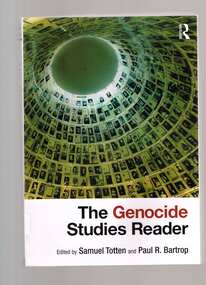
Book, Routledge, The genocide studies reader, 2009
This thorough overview of all aspects of the field of genocide studies brings together for the first time classic and contemporary writings from some of the most noted scholars writing on genocide in the fields of genocide studies, political science, history, and sociology. The Reader covers key aspects of a host of complex and thorny issues, such as the definition of genocide, theories of genocide, prevention and intervention, and its denial. This collection of writings is essential reading for anyone who wants to understand this most atrocious form of political violence that has plagued human history.Index, bib, p.552.non-fictionThis thorough overview of all aspects of the field of genocide studies brings together for the first time classic and contemporary writings from some of the most noted scholars writing on genocide in the fields of genocide studies, political science, history, and sociology. The Reader covers key aspects of a host of complex and thorny issues, such as the definition of genocide, theories of genocide, prevention and intervention, and its denial. This collection of writings is essential reading for anyone who wants to understand this most atrocious form of political violence that has plagued human history.genocide - history, genocide - case studies -
 Bay Steamers Maritime Museum
Book, R. H. Grundy, The Theory and Practice of Heat Engines, 1942
Blue cloth hard cover book of 723 pagesStamp in purple ink "TECHNICAL BOOK MAGAZINE CO. / 257-299 Swanston St / OPP MELBOURNE HOSPITAL / CENT. 2041 MELBOURNE C.T."Hand written in pencil "32/6"Handwirtten in black ink "A C King / 14 Batman S / Footscray WII / or / Locker 764 Union House " handwriten in pencil "Burthen 136 189 / Coal 49 60 / 49/136 60/189 / 36 % 31.7%non-fiction, -
 Bay Steamers Maritime Museum
Book, James Pryd, Mathematical Tables
Dark maroon hard cover book 454 pagesHandwritten inside front cover in blue pen "J.T. Young / 1941 / Probably printed / c.1900 or earlier" Handwritten in pencil on front page "H.B Freeman / Eastern Cable Coy / Sydney NSW"" second page handwritten in black ink "M. Henry -
 South West Healthcare
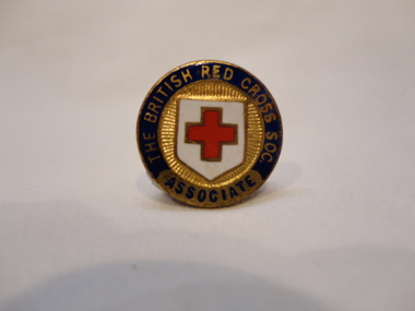
The British Red Cross Society Associate Badge, J R Gaunt, Nurse Badges, 20th Century
Metal and enamel brooch with pin fastener. Red cross in centre.Face: "BRITISH RED CROSS SOC. ASSOCIATE". Reverse: "J.R GAUNT / LONDON"nurse badges, british red cross society -
 National Vietnam Veterans Museum (NVVM)
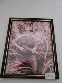
Photograph, Jungle Patrol
Framed photgraph of a Corporal in jungle greens walking through long grass. CPL is armed with an SLR and has two bandoliers of ammo around his neckCPL Chevronsphotograph, jungle patrol, slr