Showing 174497 items matching "rock-street"
-
 Ballarat Heritage Services
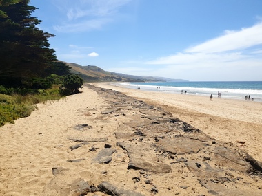
Photograph, Clare Gervasoni, Sea Wall at Apollo Bay, Victoria, 24/01/2022
In 2021, the Department of Environment, Land, Water and Planning (DELWP) constructed two new groynes and a section of rock seawall at Apollo Bay to help manage the impacts of coastal erosion. The new 70-meter-long rock groynes run perpendicular to the shoreline and be located just south of the Milford St revetment and to the south of Milford Creek. Sections of rock seawall will be constructed between the two Groynes with an aim to protect the dune, walking path, cypress trees and road from erosion. Colour photograph of a coastal scene at Apollo Bay, featuring new rock wall and groynes to protect the Great Ocean Road from erosion. apollo bay, beach, coast, groyne, rockwall, sea wall -
 Ballarat Heritage Services
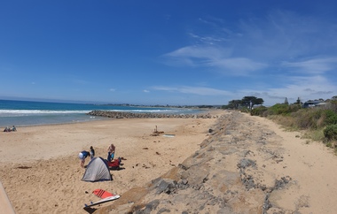
Photograph, Clare Gervasoni, Sea Wall at Apollo Bay, Victoria, 24/01/2022
In 2021, the Department of Environment, Land, Water and Planning (DELWP) constructed two new groynes and a section of rock seawall at Apollo Bay to help manage the impacts of coastal erosion. The new 70-meter-long rock groynes run perpendicular to the shoreline and be located just south of the Milford St revetment and to the south of Milford Creek. Sections of rock seawall will be constructed between the two Groynes with an aim to protect the dune, walking path, cypress trees and road from erosion. Colour photograph of a coastal scene at Apollo Bay, featuring new rock wall and groynes to protect the Great Ocean Road from erosion. apollo bay, beach, coast, groyne, rockwall, sea wall -
 Federation University Historical Collection
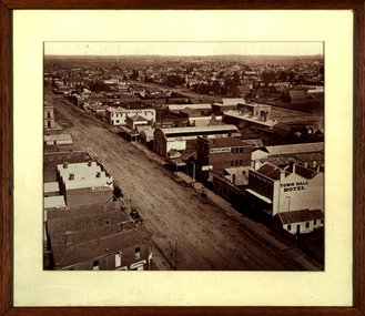
Photograph - Photograph - Sepia, Ballarat Looking South Along Armstrong Street, 1872
This photograph was taken not long after the Ballarat Town Hall tower was builtFramed sepia photograph showing a bird's eye view of Ballarat looking south from the tower of the Ballarat Town Hall. Businesses shown in the photograph include Town Hall Hotel, West's Hotel, National Loan Office, Edinburgh Castle Hotel, Magill and Coglan, Dana Street Primary School, Band of Hope and Albion Mine, I. Dean auctioneer, Pritchard, Murray, Victoria Foundry. Just south of West's is the Phoenix Foundry.ballarat, ballarat town hall, ballarat streetscape, ballarat townscape, william bardwell, fotobiennale -
 Surrey Hills Historical Society Collection
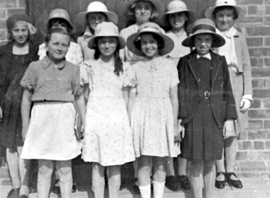
Photograph, Benson Street Methodist Church Sunday School students
Benson Street Methodist Church – now Uniting Church 1936 Rear L. to R. - Eunice Forsyth, ?, ?, Rae Homan, Yvonne Mau, Joan Shepherd Front L.to R. – Joan Thornton, Nancy Dunstan, ?, Barbara Burgess A black and white photograph of ten girls dressed in their 'Sunday best' or school uniform. Most are wearing straw sun hats. Some girls are identified.benson street methodist church, benson street uniting church, (miss) eunice forsyth, (miss) rae homan, (miss) yvonne mau, (miss) joan shepherd, (miss) joan thornton, (miss) nancy dunstan, (miss) barbara burgess, churches, sunday schools -
 Surrey Hills Historical Society Collection
Photograph, Streetscape near the corner of Victoria Crescent and Hotham Street, Surrey Hills
Prior to subdivision for housing this area was paddocks used for grazing of cattle and used as part of the course in the early days of the Surrey Hills Golf Club. Reproduced by permission of Mr John Arnold from his book: "The Riversdale Golf Club - a history, 1892-1977." Copyright to book: Riversdale Golf Club. Surrey Hills Golf Club operated from 1892-1908 then moved and became Riversdale Golf Club. The game was played across paddocks from Trafalgar Street, Mont Albert to Whitehorse Road and down Victoria Crescent to where Box Hill TAFE is now located in Elgar Road. There were problems with cows eating the tee flags! The clubhouse still exists as 30 Trafalgar Street.Black and white photo taken from the centre of a bitumen road which is flanked by bluestone guttering. Nature strips, drive cross-overs and house fences are shown. Trees on the RHS nature strip are pollarded to avoid overhead power and telephone lines. There houses in the background."Bottom: The same view today taken from the intersection of Victoria Crescent and Hotham Street, Surrey Hills."surrey hills golf club, hotham street, victoria crescent, riversdale golf club, surrey hills, john arnold -
 Stawell Historical Society Inc
Photograph - Slide, Stawell Band Marching in Main Street
Band marching in Main Street with crowds lining the Street -
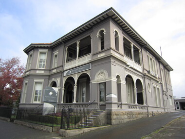
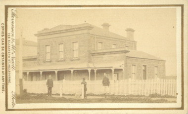 Bacchus Marsh & District Historical Society
Photograph, Court House Main Street Bacchus Marsh 1883
The Court House in Main Street Bacchus Marsh was built in 1858 using local sandstone. It opened in 1859. It has been used for jury trials, a Court of Petty Sessions, a County Court and a Crown Land sales office. Other uses included an office for the Registrar of Births and Deaths, a Dairy Inspectors office from 1863-1865, and as meeting rooms for the Bacchus Marsh Roads Board, a forerunner of the Shire Council. It was also used by the Bacchus Marsh Shire Council for its offices until at least 1884. In more recent years it has functioned as a Magistrates Court with weekly court sessions. Small sepia unframed photograph on card with gold border framing photograph. Housed in the album, 'Photographs of Bacchus Marsh and District in 1883 by Stevenson and McNicoll'. The view of the Court House building is seen from the northern side of Main Street looking south or south-east. Three men are standing in the street in front of the building. The men on the left and the right wearing police helmets appear to be police officers. The man in the middle is in civilian clothes and might be an officer or employee of the Court House. He has his dog with him. A white picket fence runs along the front of the building. The front courtyard of the building has been renovated since, but this building still operates as a court house.On the front: Stevenson & McNicoll. Photo. 108 Elizabeth St. Melbourne. COPIES CAN BE OBTAINED AT ANY TIME. On the back: LIGHT & TRUTH inscribed on a banner surmounted by a representation of the rising sun. Copies of this Portrait can be had at any time by sending the Name and Post Office Money Order or Stamps for the amount of order to STEVENSON & McNICOLL LATE BENSON & STEVENSON, Photographers. 108 Elizabeth Street, MELBOURNE. stevenson and mcnicoll 1883 photographs of bacchus marsh and district, courthouses, bacchus marsh court house -
 Ballarat Heritage Services
Photograph, Clare Gervasoni, 2 Lyons Street South, Ballarat, 28/05/2023
This building was constructed in 1901 by surgeon Dr. William Cussen, a surgeon. His name is still visible in the leadlight above the front door. In 1998 Dr Cussens was an Honorary Medical Office with of the Ballarat Orphanage. In July 1920, the building was gifted to the citizens of Ballarat for the ongoing welfare of returned servicemen and women. Sir John Monash officially opened the building as the Ballarat War Memorial Building. In 1942 a voluntary organisation called The Comforts Fund took up residence in the building with the permission of the R.S.L to transform it into a hostel, providing beds, food and support for many service men and women during World War II. It is estimated that by the end of the war in 1945, one million meals had been served. The building was returned to the R.S.L in the later part of 1945. In 2013, 2 Lyons Street South was given new life as Ballarat Premier Apartments after extensive renovations and began operating as luxury accommodation.Double storey residence in Lyons Street South, Ballarat. 2 lyons street south, rsl, ballarat premier apartments, ballarat war memorial building, the comforts fund, william cussen, surgeon -
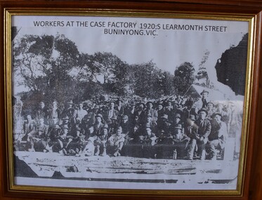 Buninyong Visitor Information Centre
Print - Photograph, Workers at the Case Factory, 1920s Learmonth Street Buninyong, Circa 1900
Howards Box factory. The Howard family (owners) resided at Netherby 606 Warrenheip Street and were involved in the Methodist Church, football, bowls and the fire brigade. James Howard owned the factory. he had two sons, Arthur and Charles. Early Buninyong. This is a rare image of early industry. Circa 1900. Framed photocopy of early photograph of workers at the case factory. Approximately 48 employees. Wood pile and trees in background, rail line in foreground.box factory, fruit boxes, factories, industry -
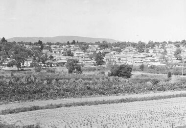 Ringwood and District Historical Society
Photograph, New housing developments, New Street, 1960 viewed from railway line near Madden Street looking south-east
Written on back of photograph, "New housing settlement New Street, 1960. From railway line near Madden Street looking south-east. Dam centre foreground". -
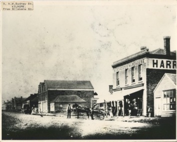 Kilmore Historical Society
Photograph, N.W Sydney Street
1860's Kilmore25cm x 20cm black and white photograph of Hudsons Store on Sydney Street from the view from Brisbane Street c. 1862. The photograph captures buildings along the street including: Harris Dublin & Manchester Warehouse, Sign to Kilmore Brewery, Hudson Hay & Corn Store, some unidentified buildings and Dunrobin Castle Hotel. Also captured, horse and carts on the street, people standing in front of the Manchester Warehouse. 3 Photograph of differing quality of the same image.Written on the back of the large copy; #3 #4 #5.10/86-34 Copy LaTr. 1860 Husdon Store - Harris' Store PHO-00073 Written on the back of the .2: 169 Husdon's Warehouse H1811 SLV Sydney Street MFN 272 c1862, -SW (- (85)Hudsons Warehouse) Note Kilmore Brewery Sign 126 7/c/ PHO-00073.2 Written on the back of .3: Kilmore 1860 169 Sydney rd from N-N-E ____ Harriss Dublin & Manchester Warehouse, Sign to Kilmore Brewery Hudson Hay & Corn Store, _________, __________, __________, _____ Dunrobin Castle Hotel,storefronts, 19th century, retail stores -
 Stawell Historical Society Inc
Photograph, 9 Seaby Street Former Crothers Home Built 1869
Colour Photgraph: Brick house with red Iron roof,, with 4 chimneys 7 white iron frnce in front. road in foreground9 Seaby Street -
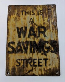 Montmorency–Eltham RSL Sub Branch
Sign - Street Sign, ‘This is a War Savings Street’ sign
Rectangular sign, discoloured with rust and dents THIS IS A WAR SAVINGS STREET -
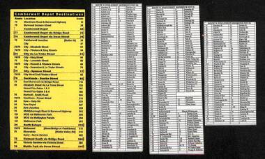 Melbourne Tram Museum
Document - List, The Met, "Camberwell Depot Destinations", "Route 70 Stop-Street Reference Nov. 05", "Route 75 Stop-Street Reference Nov. 05", c2005
Set of four lists, on laminated paper. .1 - "Camberwell Depot Destinations" list route, locations and destination code. Printed on yellow paper. .2 - "Route 70 Stop-Street Reference Nov. 05" - lists the streets and stop number in alphabetical order. .3 - "Route 75 Stop-Street Reference Nov. 05" - lists the streets and stop number in alphabetical order - A to L .4 - ditto, M to Y, Hospitals and Places of Interest.trams, tramways, yarra trams, camberwell depot, tram stops, destination roll, hospital -
 Kilmore Historical Society
Photograph, 13 Sydney Street
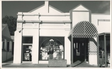
Was the site of J. Quinn Bakery and Breakells Bakery and shop20cm x 12.5 black and white photograph of the shop at 13 Sydney Street which at the time of the photograph was J.R. Mens Wear. Light coloured recently renovated building, some of the older trim remains and restored, corrugated steel awning which leads down the arcade, concrete planter box out the front of the shop. Was the location of J. Quinn Bakery and Breakells Bakery and shop. 2 picture available in the item offering slightly different angles.Written on the back: Photo 1: 1024 Photo 2: 1025baker, bakery, bakers and bakeries, shopfront, mens fashion -
 Whitehorse Historical Society Inc.
Article, 54 McCulloch Street, 2001
Article in 'The Age' Domain section.Article in 'The Age' Domain section. House built in the early 20th century at 54 McCulloch Street, Nunawading is for sale. Asking price $220,000+. Agent Phillip Webb.Article in 'The Age' Domain section. houses, mcculloch street, nunawading, no 54 -
 Stawell Historical Society Inc
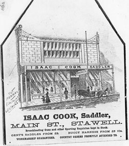
Drawing, Mr Isaac Cook, Saddler in Main Street Stawell from the P.C. News Supplement 1888 -- Sketch
Isaac Cook Saddler Main Street Line Drawing of Isaac Cook Saddler Main Street with verandah and large glass windows. Shows lady and child on footpath, man in top hat and two horse buggy with man. Details printed below diagramstawell businesses, shop -
 Tatura Irrigation & Wartime Camps Museum
Photograph, Whim Inn Corner, Hogan Street and Dhurringile Road, Tatura
Shows picture of Whim Inn corner, Hogan Street and Dhurringile Road, Tatura. Colour photograph showing the intersection of Hogan Street, and Dhurringile Road, Tatura. Known as Whim Inn corner. Before round about put in. Photograph stuck onto piece of white cardboard. hogan street tatura, dhurringile road tatura, whim inn tatura -
 Ballarat Heritage Services
Photograph - Photograph - Colour, 10 Raglan Street North, Ballarat Central
Raglan Street is located within the heritage precinct of central Ballarat. This house was built around the turn of the century, with sewerage being added in 1908. The hallway is lined with pressed metal, the remainder of the metal being used at Talbot Hall. The building was occupied by Dr Pern.Postcard size colour photo of a weatherboard house in Raglan St Ballarat.raglan street, ballarat, house, garden, architecture -
 Charlton Golden Grains Museum Inc
Photograph, Brownjohn, Reg, Charlton High Street 1988, c.1988
Charlton High Street centre 1988. Vic Arundell's Shoe Shop, Stock & Station Agent and former W. Williams Saddlery (later Bullock's Grocery). Buildings latr demolished to become the Traveller's Rest. Williams St renamed John Curtin Drive.Colour photograph of Vic Arundell's shop and former W. Williams Saddlery on the corner of High St and Williams St. For Sale sign over the middle building. White ute parked in front of Arundell's. Another ute parked at side of buildings.bullocks grocery, business, industry, high street, arundell, shoe shop, saddlery, w. williams -
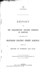 Melbourne Tram Museum
Document - Report, Victorian Parliament, "Report - The Parliamentary Standing Committee re the Beaumaris Electric Street Railway.", Dec. 1916
Printed - 6 page foolscap, stapled on left hand side, 2 sections, Victorian State Parliamentary Report titled "Report - The Parliamentary Standing Committee on Railways on the question of the Beaumaris Electric Street Railway." - dated 22 December 1916. References previous reports, Black Rock, Beaumaris, residential development, routes and costs of the proposed tramway, costs provided by the Chief Engineer for Railway Construction, E. Kernot, and Committee recommendations - tempered by the War.trams, tramways, sandringham, black rock, beaumaris, railways, tramways, proposals -
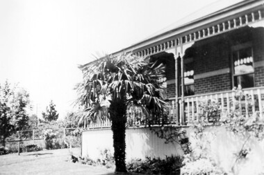 Surrey Hills Historical Society Collection
Photograph, 3 Beatty Street, Mont Albert
Location is now 3 Beatty Street, Mont Albert although electoral entries for the Lodewyckx family in the 1930s give the address as 1 Beatty Street. This address is a more contemporary house and part of the original garden was subdivided off at some stage. The property's original address was 1 Victoria Street, renamed in 1917. The house was built c 1891 and from then until 1905 it was home to Leopold A Carter (dentist of Collins Street); followed by James J Hempill (broker) from 1905 -1907. he called it 'Manchling'. There were several other owners or tenants before the Lodewyckx family moved into it in 1920. They named the property 'Huize Eikenbosch' (Dutch meaning House of Oaks). It was set in 1/3 hectare with a formal garden, vegetable garden, orchard and chicken run. Augustin had a life-long interest in growing vegetables and planted many European trees, especially oaks. Augustin Lodewyckx was born and educated in Belgium, was appointed Professor of Modern Languages at Stellenbosch, South Africa and later joined the Belgium Colonial Service. In 1915 he commenced as lecturer in German at Melbourne, becoming Associate Professor in 1923. He had married Anna Sophia Hansen* in South Africa in 1910. They had 2 children Karel Axel, librarian of the University of Melbourne, and daughter Hilma Dymphna, translator, editor and wife of Manning Clark, historian. In 1942 Augustin introduced a university course in Dutch and also undertook research into German immigration to Australia. He retired in 1946 and died in 1964. (*Thought to be nick-named Mina.) A black and white photograph of a corner of a house with a large palm tree in front. There is decorative wooden balustrading on the verandah.beatty street, mont albert, mina lodewyckx (mrs), augustin lodewyckx (mr), karel axel lodewyckx (mr), axel lodewyckx (mr), anna sophia lodewyckx (mrs), hilma dymphna lodewyckx (miss), dymphna lodewyckx (miss), hilma dymphna clark (mrs), dymphna clark (mrs), architectural features -
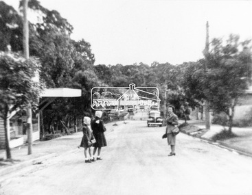 Eltham District Historical Society Inc
Negative - Photograph, Were Street, Montmorency, 8 Oct 1950
From left; Constance and Betty Dandy and possibly their mother, Mrs Dandy, standing in Were Street. Photos shows Smyth's Milk Bar and Montmorency Railway Station in distance; Tozer and Whiteways Grocer on left. Mrs Dandy ran a haberdashery store in Were St.This photo forms part of a collection of photographs gathered by the Shire of Eltham for their centenary project book,"Pioneers and Painters: 100 years of the Shire of Eltham" by Alan Marshall (1971). The collection of over 500 images is held in partnership between Eltham District Historical Society and Yarra Plenty Regional Library (Eltham Library) and is now formally known as the 'The Shire of Eltham Pioneers Photograph Collection.' It is significant in being the first community sourced collection representing the places and people of the Shire's first one hundred years.Digital image 120 format B&W negative Black and white printOne print copy inscribed on reverse: Montmorency Station 8-10-50 Smyths ? Milk Bar Girls Constance and Bettey Dandy ? Tozer and Whiteways Grocer on left ?sepp, shire of eltham pioneers photograph collection, montmorency, were street, betty dandy, constance dandy, milk bar, montmorency railway station, railway station, shopping centre, smyth's milk bar, tozer and whiteways grocer, were street shops -
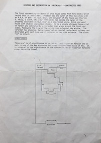 Kew Historical Society Inc
Document, Pru Sanderson Design Pty Ltd, History and Description of 'Glencara', Sackville Street, 1984-1988
History, description, site plan and house plan of 'Glencara' at 59 Sackville Street, Kew.2-page document with site plan and internal layout of Glencara (b.1893,) 59 Sackville Street, Kew. The text in the document is identical to that in Pru Sanderson's Kew Conservation Study (1988).glencara -- sackville street -- kew (vic), houses -- sackville street -- kew -
 Rutherglen Historical Society
Image, c1900
One of three black and white photographs mounted on orange paper. This one is of Main Street Rutherglen, featuring the Victoria Hotel. The Standard Bakery is visible further up the street.At top left of photo: "Main Street, East Rutheglen" Caption on mount: "Victoria Hotel"victoria hotel, hotels, pubs, main street, standard bakery -
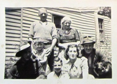 Ballarat Heritage Services
Gervasoni family at their Albert Street, Daylesford Property, c1940, c1940
This photograph was taken on the day that Gus Gervasoni left for army service during World War Two.Black and white photograph of members of the Gervasoni family at George and Anne Gervasoni's house in Albert Street, Daylesford. Standing left to right: George Gervasoni, Anne Gervasoni (Pedretti) Front left to right: Gus Gervasoni (in uniform), Kevin George Lock, John Hogan Gervasoni, Una Gervasoni, Jack Gervasoni. Gus, Vera and Jack were sibling, the children of George and Anne, John was the son of Gus, who is in army uniform. Kevin Lock stands in front of his grandfather, George.george gervasoni, anne gervasoni, anne pedretti, gus gervasoni, john hogan gervasoni, daylesford, albert street, daylesford -
 Melbourne Tram Museum
Document - Notice, Melbourne & Metropolitan Tramways Board (MMTB), "Reconstruction of Tram Tracks in Elizabeth Street at Collins and Bourke Street", 20/11/1978 12:00:00 AM
Typed notice or instruction of foolscap paper titled "Reconstruction of Tram Tracks in Elizabeth Street at Collins and Bourke Street", giving tram arrangements for Elizabeth Street services - other services not affected. Advises of bus arrangements to and from Lonsdale St for Sunday 26/11/1978. Signed by R. C. Drummond as Traffic Manager.Has in ink in the top left hand corner "66 Con"trams, tramways, mmtb, trackwork, elizabeth st -
Federation University Historical Collection
Photograph, Renovation of the Summerscale Building, Sturt Street, Ballarat, c2003
Sumerscales building on the corner of Sturt Street and Camp Street, Ballarat.summerscales building, camp street, sturt street -
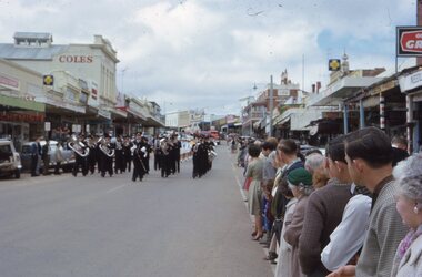 Stawell Historical Society Inc
Photograph - Slide, Stawell Band Marching in Main Street
Stawell Band Marching in Main Street with crowd lining the Street -
 Stawell Historical Society Inc
Photograph - Slide, Main Street at Easter with flags
Main Street Look toward the Grampians with flags over the Street.