Showing 4555 items matching "the avenue"
-
 Mt Dandenong & District Historical Society Inc.
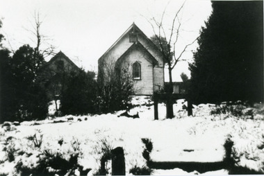
Photograph, St Matthew's Anglican Church Olinda
View from Monash Avenue of St Matthew's Anglican Church with snow covering ground. The church was built in 1903, but this photograph is post 1935 as the Church Hall can be seen behind the trees on the left.olinda, church, st matthew's church, anglican church, st matthew's anglican church, monash avenue, snow -
 Melbourne Tram Museum
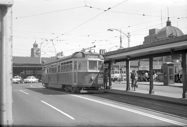
Negative, Travis Jeffrey, 11/06/1960 12:00:00 AM
Negative of tram 849 at Batman Avenue terminus. Tram has destination Prahran and Route No 70. note advert on front of tram for Magree Knitwear and the kiosk on the right hand side and a telephone box.Paper folder that contained the negative had "NR31A" written in red ink, "M10" written in pencil, "21A" written in blue ink, and date stamped as 11 Jun 1960.trams, tramways, sw5 class, batman ave, swanston st, tram 849 -
 Lakes Entrance Historical Society
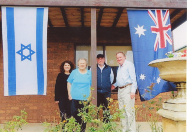
Photograph - Shirley and Brian Hancock, Jeffrey Lederman and Sharon Siger, Hancock family Lakes Entrance Victoria, 1/12/2016 12:00:00 AM
Lederman family were financiers of East Gippsland Timber Industry - . Shirley Hancock's Sharon Frock Salon on Esplanade Lakes Entrance was named after Sharon SigerColour photograph showing Shirley and Brian Hancock welcoming Jeffrey Lederman and Sharon Siger nee Lederman on verandah at 5 Uplands Avenue, with Australian and Jewish flags flying, Lakes Entrance Victoriabusinesses, timber industry -
 Ringwood and District Historical Society
Map, Plan of Subdivision - State School Estate, Ringwood East, Victoria - (Undated, circa 1920s)
Map of land for sale attached to green cardboard backing with handwritten notations showing numbered allotments on Dublin Road, Holland Road, King Street, Charles Street and Purser Avenue, Ringwood East.Locality plan includes reference to proposed Ringwood East railway station which opened in 1925. -
 Greensborough Historical Society
Business Card, Clements Avenue Automotive, Clements Avenue Automotive, Bundoora, 2018c
Clements Avenue Automotive is an automobile repair and service business in BundooraBusiness card, printed in colour both sidesLocation map, contact detailsautomotive repairs, bundoora, clements avenue bundoora -
 Greensborough Historical Society
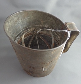
Flour Sifter, Kande, Metal flour sifter, 1954c
This sifter was used at Poulter Avenue Greensborough for over 55 years.Owned and used by the Colvin family for over 55 years.Metal sifter with metal handle and green painted winder. Some rust damage and a hole in wire."Kande" brand inside outline map of Australia, stamped on side with patent information.flour sifter -
 Greensborough Historical Society
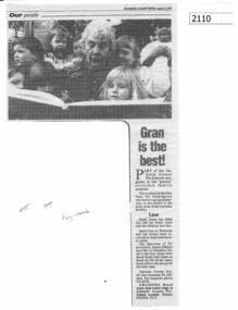
Newspaper clipping (copy), Diamond Valley News, Gran is the best!, 09/08/1993
Hazel Amos volunteers as a 'granny' at Gabonia Avenue Pre-School.Copy of news clipping, black text and image.hazel amos, gabonia ave pre school -
 Eltham District Historical Society Inc
Photograph, Shire of Eltham, Montmorency - Calrossie Avenue (newly constructed road and footpaths), November 1966
New paved road, footpaths and gutters on Calrossie Avenue, Montmorency.This photo forms part of a collection of photographs gathered by the Shire of Eltham for their centenary project book, "Pioneers and Painters: 100 years of the Shire of Eltham" by Alan Marshall (1971). The collection of over 500 images is held in partnership between Eltham District Historical Society and Yarra Plenty Regional Library (Eltham Library) and is now formally known as 'The Shire of Eltham Pioneers Photograph Collection.' It is significant in being the first community sourced collection representing the places and people of the Shire's first one hundred years.Digital imagesepp, shire of eltham pioneers photograph collection, montmorency, calrossie avenue, road construction, footpaths -
 Eltham District Historical Society Inc
Photograph, Dedication of new Avenue of Honour Memorial, Main Road, Eltham, 2 June 2015, 2 June 2015
Cr Helen Coleman speaks at the dedication of the new Avenue of HonourBorn Digitalavenue of honour, war memorials, plaques, main road, eltham, helen coleman -
 Eltham District Historical Society Inc
Photograph, Dedication of new Avenue of Honour Memorial, Main Road, Eltham, 2 June 2015, 2 June 2015
Cr. Helen Coleman speaks at the launch of the new Avenue of HonourBorn Digitalavenue of honour, war memorials, plaques, main road, eltham, helen coleman -
 Stawell Historical Society Inc
Photograph, O’Callaghan Street & Clifton Avenue corner Stawell 2004
Street Scene Cnr. O’Callaghan St. & Clifton Avenue. 2004stawell -
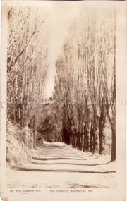 Malmsbury Historical Society
Postcard (Item), Postcard Poplar Avenue Malmsbury Gardens Rose P4157, Malmsbury c1923
Associated with - Rose Series P4157 Buildings - "Poplar Avenue, Gardens" -
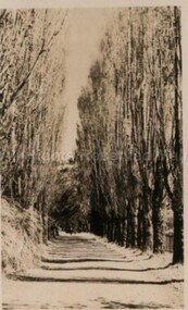 Malmsbury Historical Society
Postcard (Item), Postcard Poplar Avenue Malmsbury Gardens Rose Series P4157, Malmsbury c1923
Associated with - Rose Series P4157 Buildings - "Poplar Avenue, Gardens" -
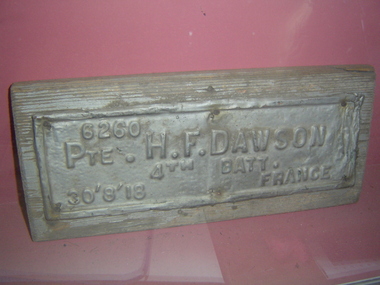 Glen Eira City Council History and Heritage Collection
Plaque, memorial
Originally located in the City of Caulfield and City of Brighton Avenues of Honour. Metal plaque on wooden base with embossed lettering: "6260 PTE H.F. DAWSON 4th BATT. 30'8'18 FRANCE""6260 PTE H.F. DAWSON 4th BATT. 30'8'18 FRANCE" embossed on metal. -
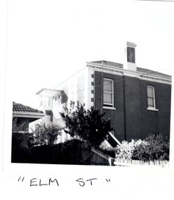 Glen Eira Historical Society
Article - Elm Avenue, 21, Elsternwick
1/One small black and white photograph of the residential property in 21 Elm Avenue. 2/Two advertisements for the sale of Flat 3, 21 Elm Avenue from unknown publications dated 07/03/2006 and 14/03/2006. The auction was to be held on 01/04/2006. Includes two exterior and one interior photograph Recent sale notice of 2/21 Elm Avenue dated 2013. Includes colour exterior photograph 4/Copy of letter dated 17/02/1998 from Heritage Victoria to J and B Chi Lok Wong, owners of 21 Elm Avenue, concerning nomination of the property for the Heritage Registerelm avenue, elsternwick, chimneys, brick houses, victorian style, architectural styles, architectural features, flats, hopetoun street, walton manor -
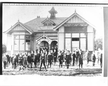 Canterbury History Group
Photograph - Canterbury Grammar School, c1903
Pupils standing in the front of Canterbury Grammar School, corner of Alexandra Avenue and Canterbury Road. The school began in the Methodist Church Hall , Balwyn Road approx 1902, moved to Goldings Hall , and from1903 - 1913 operated from Alexandra Avenue, Canterbury Road.canterbury, canterbury road, alexandra avenue, canterbury grammar school, goldings hall, methodist church, independent schools students -
 Greensborough Historical Society
Photograph - Digital Image, Anne Paul, Cherry Street Macleod - Avenue of Honour, 26/06/2019
Photographs of the Avenue of Honour in Cherry Street Macleod. Established in 1919 as a memorial to service men and women who gave their lives in World War 1, the Avenue is a single row of sugar gums, the former Mont Park hospital grounds are adjacent. These photographs show the plaque. Digital copy of 3 colour photographs.macleod avenue of honour, cherry street macleod -
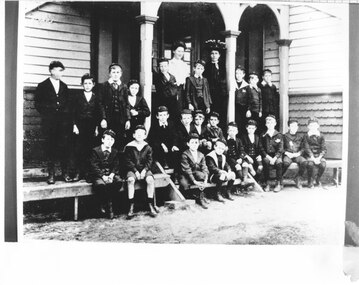 Canterbury History Group
Photograph - Canterbury Grammar School, c1903
Teachers and pupils of Canterbury Grammar School situated on the corner of Canterbury Road and Alexandra Avenue|Canterbury Grammar began approx. 1902 in the Methodist Church Hall in Balwyn Road, moved to Goldings Hall.The school was at Canterbury Road and Alexandra Avenue from 1903-1913canterbury, canterbury grammar school, alexandra avenue, goldings hall, independent schools, canterbury road, methodist church -
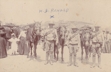 The Beechworth Burke Museum
Photograph, c1916
Taken during World War 1, this photo is taken of three soldiers and their horses, featuring families in the background. One of the men featured is H. J. Ronald.This photograph is historically significant as it provides insight into the uniforms and clothing worn during the early 20th century and World War 1 period. Black and white rectangular photograph printed on photograph paper and mounted on a beige card.Observe: H. J. RONALD Reverse: H. J. Ronald / Donated by George Ronald / 49 Jellico Avenue / 5898 (crossed out) / Tallangattamilitary album, burke museum, beechworth, beechworth museum, world war one, wwi, horses, h.j.ronald, soldiers, soldiers and horses -
 Ringwood and District Historical Society
Photographs, 1979-80 MMBW pipe line project at Hubbard Reserve, North Ringwood � View behind no. 39 Burlock Avenue showing compressor, mole pit cover and the big box tree
Part of a 43-photo record of the MMBW�s engineering feat in drilling a 12 inch pipe line up to 40 feet deep through rock hardened by volcanic action associated with geological fault that occurs along the line. The work took place from October 1979 to May 1980 on the southern boundary of Hubbard Reserve, North Ringwood. The collection was presented to the Ringwood Historical Research Group by J Clarke on 9th June 1980.E560 N26 Jan 1980 A43 View behind no. 39 Burlock Avenue showing compressor, mole pit cover and the big box tree -
 Ringwood and District Historical Society
Photographs, 1979-80 MMBW pipe line project at Hubbard Reserve, North Ringwood � Manhole behind 29 Burlock Avenue
Part of a 43-photo record of the MMBW�s engineering feat in drilling a 12 inch pipe line up to 40 feet deep through rock hardened by volcanic action associated with geological fault that occurs along the line. The work took place from October 1979 to May 1980 on the southern boundary of Hubbard Reserve, North Ringwood. The collection was presented to the Ringwood Historical Research Group by J Clarke on 9th June 1980.E566 N5 13 May 1980 A43 Manhole behind 29 Burlock Avenue, 38 feet deep. Debbie place is on the far right. -
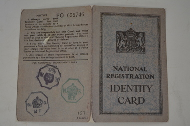 Wangaratta RSL Sub Branch
Souvenir - British Identity Card
Reproduction of a wartime British Identity Card from magazine entitled Images of War 1939-1945 The Real Story of World War II - A Marshall Cavendish Collection in association with the Imperial War Museum. Small folded cardboard of grey colour with pale blue background in centre. Has black lettering and crest. Information contains name, address and signature of person. Is an British National Registration Card. Number: BCDP 157:2, Abraham Van Lier, Class A of 89 Sherwood Avenue Greenford Middlesex England. Issued on 22 June 1943.british, world war 2, national registration, identity card -
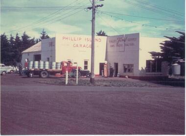 Phillip Island and District Historical Society Inc.
Photographs, Fuji Film, Gullifers Garage, 1950's & 60's
Two of a collection of photographs donated by Bernie De Le Haye.350-09: Colour photograph of Phillip Island Garage. Cnr Thompson Avenue and Chapel Street - now where Gullivers Restaurant is located (2017). Loaded truck and people outside the building. Printed on the front: "Sales Ford Service" "Cars Trucks Tractors" Phone (8). Shell bowsers. 350-10: Colour photograph of the De La Haye Bros. Self Service store in Thompson Avenue, Cowes on the left hand side. Three people and two cars in front.As on the buildings.phillip island garage, de le haye bros self service cowes, bernie de la haye, gullifer family -
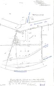 Ringwood and District Historical Society
Document - Copy of Lands Department Field Notes - Parish of Ringwood, Victoria, Field Notes - OP34838 - surveyed in 1919 by D. Barker
5615b Foolscap size photocopy of survey map with handwritten notations. References include Braeside Avenue, Mount Dandenong Road, Rosedale Court, Railway Avenue, cyclone fence, Sec A, WB house, old tennis court netted, stable, old shed, tank stand, orchard, Township Boundary, netting fence, Railway fence, Ringwood to Lilydale Railway, I certify that these fieldnotes are a true copy of the actual results of observations & measurements taken by me on the ground (signed) D. Barker (1919). -
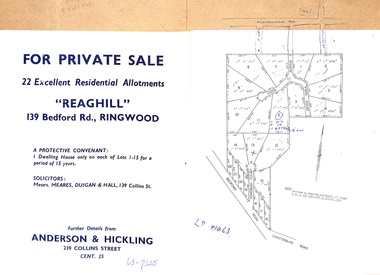 Ringwood and District Historical Society
Document - Folder, Reaghill Estate Subdivision, Ringwood, Victoria - circa 1958
Bifold land sale brochure glued to brown stationery folder with advertisement including map of original subdivision (circa 1958) and subsequent 1982 re-subdivision of Lot 7 Vista Avenue - LP41463 - Part of Crown Allotment 43, Parish of Ringwood, and 4-page brochure for sale of 4 luxury new homes built by Bovis Homes Aust. P/L as presented by Lyndsay Edmonds Homes. Subdivision includes Bedford Road, Homebush Court, Vista Avenue and Vista Court. Original protective covenant: "One dwelling house only on each of Lots 1-15 for a period of 15 years". Agent - Anderson & Hickling, 239 Collins Street, Melbourne. (Phone) Cent.25. -
 Phillip Island and District Historical Society Inc.
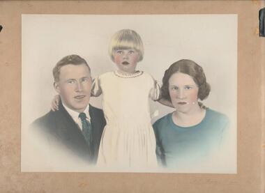
Portrait, A. J. Murray, Odlund Family, Late 1940's
Odlunds had an Electrical Sales and Repairs shop in Thompson Avenue, Cowes.Hand tinted portrait of Mr Adolf & Mrs Gertrude Odlund and daughter Joy.odlund family, anne davie -
 Greensborough Historical Society
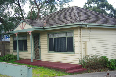
Photograph - Digital image, Marilyn Smith, House, Poulter Avenue Greensborough 2016, 11/08/2016
Two photographs of the 4 Poulter Avenue Greensborough. Front and rear aspects.Digital copy of colour photograph.poulter avenue greensborough -
 Uniting Church Archives - Synod of Victoria
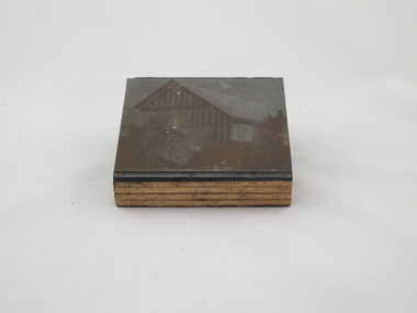
Photographic print block
Glen Iris Presbyterian Church on the corner of High Street and Allison Avenue. Exterior of unidentified church building."6" "SIX"glen iris presbyterian church -
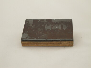
 Uniting Church Archives - Synod of Victoria
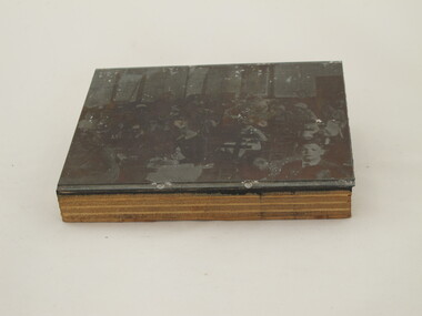
Photographic print block
Glen Iris Presbyterian Church on the corner of High Street and Allison Avenue. Interior of church hall with women and children sitting on wooden benches. "7"glen iris presbyterian church -
 Uniting Church Archives - Synod of Victoria
Photographic print block
Glen Iris Presbyterian Church on the corner of High Street and Allison Avenue. Interior of hall with a group of teenage girls and boys.On back: "14"glen iris presbyterian church