Showing 17376 items
matching view-master
-
 Greensborough Historical Society
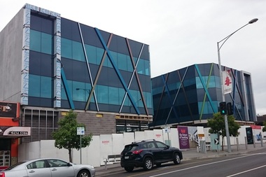
Photograph - Digital image, Marilyn Smith, 78 Main Street Construction - Front View, 18/01/2016
Development on Main Street Greensborough (front), January 2016. Shows the changing streetscape of Main Street.Digital copy of colour photographmain street greensborough -
 Greensborough Historical Society
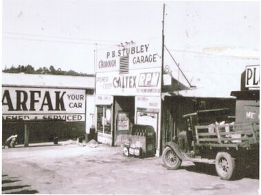
Photograph - Digital Image, Stubley Garage - external view, 1946_
Stubley Garage 1946. The Stubley Group began in 1946 when Purcell Stubley purchased a site with petrol bowsers in Main Street from 'Snowy' Jessop. In 1948 Purcell began building the new Stubley Motors, working round the old site to keep the business operating. It was completed in 1951.Digital copy of black and white photographpurcell stubley, stubley motors, stubley group greensborough -
 Greensborough Historical Society
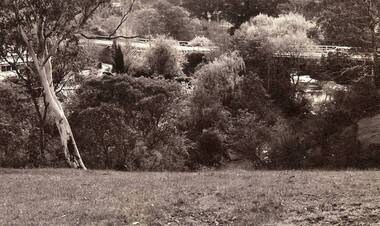
Photograph - Digital image, Jan Lewis, View From Flintoff Street Swing Bridge to the Sondemeyer's House in Briar Hill circa 1958, 1958c
From Flintoff Street swing bridge to Sondemeyer's circa 1958 Digital copy of black and white photographflintoff street, sondemeyers hill -
 Greensborough Historical Society
Photograph - Digital image, Jan Lewis, View from Sondemeyer's House overlooking the Greensborough Tea Gardens and bridge circa 1958, 1958c
From Sondemeyer's overlooking Tea Gardens and bridge circa 1958Digital copy of black and white photographsondemeyers hill -
 Greensborough Historical Society
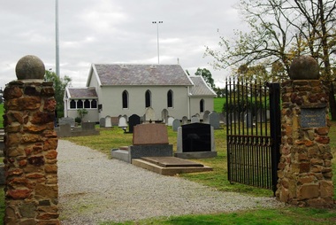
Photograph - Digital image, Marilyn Smith, St Katherine's Church St Helena: View of Church through entrance gates, 29/05/2015
St Katherine's Church St Helena dates from 1858. The Church was built by Major Anthony Beale in memory of his wife Katherine Rose Beale. This photograph shows the Church through the entrance gates.Digital copy of colour photographst katherines church st helena, anthony beale -
 Greensborough Historical Society
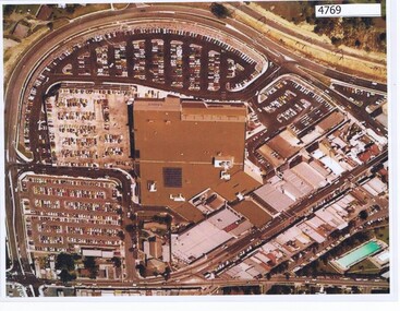
Aerial Photograph, Greensborough Plaza Aerial View, 1979c
Early aerial photograph of Greensborough Plaza, 1970.Colour photocopy of aerial survey, laminatedgreensborough plaza -
 Glenelg Shire Council Cultural Collection
Photograph, View across North Portland to Bridgewater Bay, 1968
Port of Portland Authority archives.Front: (no inscriptions) Back: LOOKING ACROSS NORTH PORTLAND TOWARDS BRIDGEWATER BAY JULY. 1968port of portland, bridgewater bay, wool stores -
 Eltham District Historical Society Inc
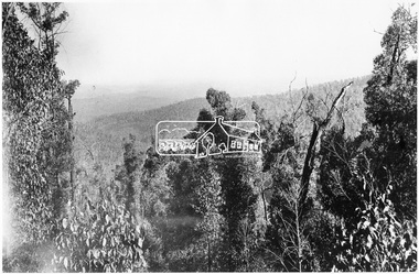
Photograph, View from the Mountain Trail, Kinglake
Source: Mrs. McMinn, KinglakeThis photo forms part of a collection of photographs gathered by the Shire of Eltham for their centenary project book,"Pioneers and Painters: 100 years of the Shire of Eltham" by Alan Marshall (1971). The collection of over 500 images is held in partnership between Eltham District Historical Society and Yarra Plenty Regional Library (Eltham Library) and is now formally known as the 'The Shire of Eltham Pioneers Photograph Collection.' It is significant in being the first community sourced collection representing the places and people of the Shire's first one hundred years.Digital imagesepp, shire of eltham pioneers photograph collection, kinglake, mountain trail -
 Eltham District Historical Society Inc
Negative - Photograph, Kinglake National Park; view from the Mountain Trail
The Kinglake National Park was established on 11,300 acres in the Shire of Eltham in 1928.This photo forms part of a collection of photographs gathered by the Shire of Eltham for their centenary project book,"Pioneers and Painters: 100 years of the Shire of Eltham" by Alan Marshall (1971). The collection of over 500 images is held in partnership between Eltham District Historical Society and Yarra Plenty Regional Library (Eltham Library) and is now formally known as 'The Shire of Eltham Pioneers Photograph Collection.' It is significant in being the first community sourced collection representing the places and people of the Shire's first one hundred years.Digital image 4 x 5 inch B&W Negsepp, shire of eltham pioneers photograph collection, kinglake, kinglake national park, mountain trail -
 Eltham District Historical Society Inc
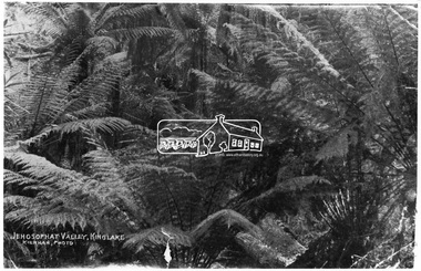
Photograph, Kinglake National Park; view from the Mountain Trail
Kinglake National Park was established in 1928 on 11,300 acres in the Shire of Eltham. Jehosophat Valley was named by the Hotelier Frank Thomson's father, who was so struck with the grandeur of the valley in all its pristine beauty that he 'ejaculated the word Jehosophat.'This photo forms part of a collection of photographs gathered by the Shire of Eltham for their centenary project book,"Pioneers and Painters: 100 years of the Shire of Eltham" by Alan Marshall (1971). The collection of over 500 images is held in partnership between Eltham District Historical Society and Yarra Plenty Regional Library (Eltham Library) and is now formally known as 'The Shire of Eltham Pioneers Photograph Collection.' It is significant in being the first community sourced collection representing the places and people of the Shire's first one hundred years.Digital imagesepp, shire of eltham pioneers photograph collection, kinglake, kinglake national park, view, bush, ferns, jehosophat -
 Eltham District Historical Society Inc
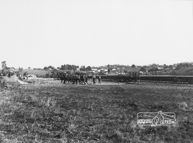
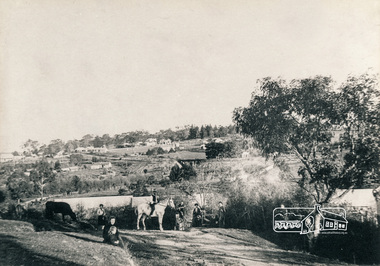
Photograph, Panoramic View of Diamond Creek Township, c.1912, 1912c
Digital copy of a framed photograph purchased at a market stall. The long low flat object behind the men and the railway wagon is probably the railway platform before the buildings were added. Digital copy of black and white photograph. (Second photo shows a detail of the first with colouring added digitally.) diamond creek -
 Eltham District Historical Society Inc
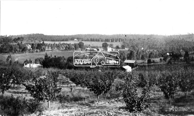
Photograph, Research. Main Road left to right showing school on left top. View from Orchard. Ref. 511 looking south-south west
Source: Mrs. E.R. Reynolds, Thompson Crescent, ResearchThis photo forms part of a collection of photographs gathered by the Shire of Eltham for their centenary project book,"Pioneers and Painters: 100 years of the Shire of Eltham" by Alan Marshall (1971). The collection of over 500 images is held in partnership between Eltham District Historical Society and Yarra Plenty Regional Library (Eltham Library) and is now formally known as the 'The Shire of Eltham Pioneers Photograph Collection.' It is significant in being the first community sourced collection representing the places and people of the Shire's first one hundred years.Digital imagesepp, shire of eltham pioneers photograph collection, research (vic.) -
 Eltham District Historical Society Inc
Photograph, View looking southwest from near Manatunga Circuit across the Diamond Valley United Soccer Club field, Greensborough, c.1986, 1986c
Greensborough Plaza at far left. Railway line running horizontally across centre of picture. Three colour photographs and one digital panorama created from two of the three images. Colour photographs originally located in a magnetic style album titled 'Greensborough Bypass 1990s 5' suffering significant degradation. No information contained in album or on reverse of photos except where noted. Relocated to archival photosafe storage.manatunga circuit, greensborough plaza, diamond valley united soccer club, greensborough -
 Eltham District Historical Society Inc
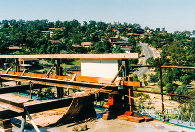
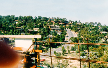
Photograph, View looking northwest along Plenty River Drive, Greensborough from outside No. 64, c.1986, 1986c
Shows the eastern bridge of the Greensborough Bypass under construction. Colour photograph originally located in a magnetic style album titled 'Greensborough Bypass 1990s 5' suffering significant degradation. No information contained in album or on reverse of photos except where noted. Relocated to archival photosafe storage.greensborough bypass, road construction, plenty river drive, greensborough -
 Eltham District Historical Society Inc
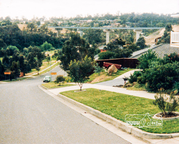
Photograph, Southeast view from new bridge over Plenty River looking along Plenty River Drive, Greensborough Bypass construction, c.1986, 1986c
Mura Close and Tangari Court visible on left, Warriparri Crescent on right of Plenty River Drive.Colour photograph originally located in a magnetic style album titled 'Greensborough Bypass 1990s 5' suffering significant degradation. No information contained in album or on reverse of photos except where noted. Relocated to archival photosafe storage.greensborough bypass, road construction, greensborough, mura close, tangari crescent, plenty river drive, warriparri crescent -
 Eltham District Historical Society Inc
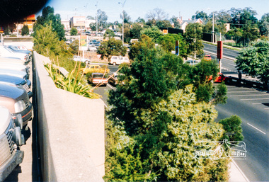
Photograph, View from Greensborough Plaza just north of Lorimer Street looking south to Grimshaw Street, c.1986, 1986c
Colour photograph originally located in a magnetic style album titled 'Greensborough Bypass 1990s 5' suffering significant degradation. No information contained in album or on reverse of photos except where noted. Relocated to archival photosafe storage.greensborough bypass, road construction, greensborough, greensborough plaza, lorimer street, grimshaw street -
 Eltham District Historical Society Inc
Photograph, View of Diamond Valley Library from the new pedestrian overpass; Greensborough Bypass construction, c.1986, 1986c
Colour photograph originally located in a magnetic style album titled 'Greensborough Bypass 1990s 5' suffering significant degradation. No information contained in album or on reverse of photos except where noted. Relocated to archival photosafe storage.greensborough bypass, road construction, greensborough, diamond valley library -
 Eltham District Historical Society Inc
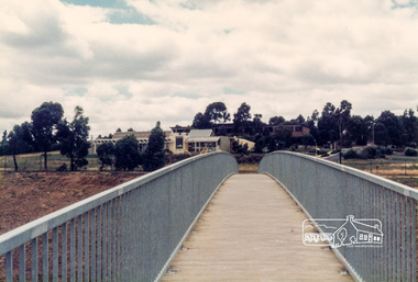
Photograph, View of the new pedestrian overpass from the carpark at Diamond Valley; Greensborough Bypass construction, c.1986, 1986c
Colour photograph originally located in a magnetic style album titled 'Greensborough Bypass 1990s 5' suffering significant degradation. No information contained in album or on reverse of photos except where noted. Relocated to archival photosafe storage.greensborough bypass, road construction, greensborough, diamond valley library -
 Eltham District Historical Society Inc
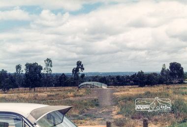
Photograph, View of 'Willis Vale', Greensborough, 1906, 1906c
'Willis Vale' home of the Partington family is shown in this photograph as well as the area now known as Partington's Flat. The area was owned and farmed by the Partington family from the 1870s. Willis Vale was destroyed by fire in the 1960sBlack and white photograph copy originally located in a magnetic style album titled 'Greensborough Bypass 1990s 5' suffering significant degradation. No information contained in album or on reverse of photos except where noted. Relocated to archival photosafe storage.greensborough, partingtons flat, partington family, willis vale -
 Eltham District Historical Society Inc
Photograph, Rear view of Grand Garden Chinese Restaurant, cnr Main Road and Luck Street, and Pizza Pasta Restaurant, Commercial Place, Eltham, late 1970s, 1970s
Colour photographgrand garden chinese restaurant, luck street, main road, restaurants, commercial place, pizza pasta restaurant -
 Eltham District Historical Society Inc
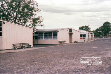
Photograph, Marjorie North, Pre-school and Infant Welfare Centre at rear of Petrie Park, Mountain View Road, Montmorency, Jan 1986, 1986
Negatives supplied by Marjorie North 1 July 1986 for Montmorency France albumRoll of 35mm colour negative film, 4 of 6 stripsKodak CP 100 5094montmorency, petrie park, petrie park hall, infant welfare centre, mountain view road -
 Eltham District Historical Society Inc
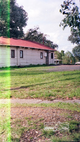
Photograph, Marjorie North, Uniting Church front porch, Mountain View Road, Montmorency, Jan 1986, 1986
Negatives supplied by Marjorie North 1 July 1986 for Montmorency France albumRoll of 35mm colour negative film, 4 of 6 stripsKodak CP 100 5094montmorency, petrie park, petrie park hall, mountain view road, uniting church -
 Eltham District Historical Society Inc
Photograph, Marjorie North, Rear view of Montmorency State Primary School looking towards Rattray Road, 8 Feb 1986, 1986
Negatives supplied by Marjorie North 1 July 1986 for Montmorency France albumRoll of 35mm colour negative film, 4 of 6 stripsKodak CP 100 5094montmorency, rattray road, montmorency state primary school -
 Eltham District Historical Society Inc
Photograph, Marjorie North, Anglican Church St Faiths, Mountain View Road, Montmorency, 1985, 1986
Negatives supplied by Marjorie North 1 July 1986 for Montmorency France albumRoll of 35mm colour negative film, 3 stripsKodak CL 200 5093montmorency, st faiths anglican church, mountain view road -
 Eltham District Historical Society Inc
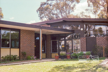
Photograph, Marjorie North, Uniting Church Hall and Kindergarten complex, Mountain View Road, Montmorency, 1986
Negatives supplied by Marjorie North 1 July 1986 for Montmorency France albumRoll of 35mm colour negative film, 3 stripsKodak CL 200 5093montmorency, mountain view road, uniting church -
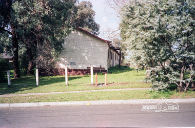
 Eltham District Historical Society Inc
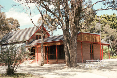
Photograph, Briar Hill Hall, 132 Mountain View Road, Briar Hill
Roll of 35mm colour negative film, 4 stripsKodak GA 100 5095shire of eltham, briar hill hall, briar hill, mountain view road -
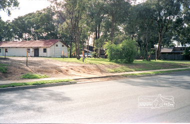
 Eltham District Historical Society Inc
Photograph, Briar Hill Hall, 132 Mountain View Road, Briar Hill
Roll of 35mm colour negative film, 4 stripsKodak GA 100 5095shire of eltham, briar hill hall, briar hill, mountain view road -
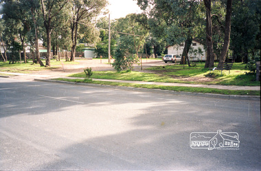
 Eltham District Historical Society Inc
Photograph, Briar Hill Hall, 132 Mountain View Road, Briar Hill
Roll of 35mm colour negative film, 4 stripsKodak GA 100 5095shire of eltham, briar hill hall, briar hill, mountain view road -
 Eltham District Historical Society Inc
Photograph, Briar Hill Hall, 132 Mountain View Road, Briar Hill
Roll of 35mm colour negative film, 4 stripsKodak GA 100 5095shire of eltham, briar hill hall, briar hill, mountain view road