Showing 1128 items matching "waterway"
-
 Lakes Entrance Historical Society
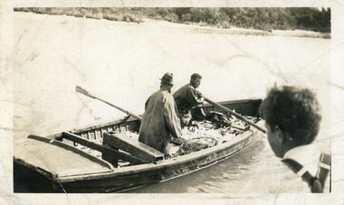
Photograph - Fishing Industry, fishing boat Lakes Entrance Victoria, 1940 c
Black and white photograph of fishing boat half full of fish being rowed away from unseen jetty, head and shoulders of young boy on right of image. Lakes Entrance Victoriafishing industry, boats and boating, fish, waterways -
 Lakes Entrance Historical Society
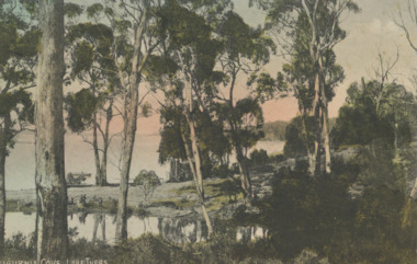
Postcard - Lake Tyers, VSM Series 112942, 1905c
Tinted postcard of Kaligurnia Cove showing calm lake beyond tall sparse timber, boat on lake, three people at waters edge Lake Tyers VictoriaKaligurnia Cove, Lake Tyerswaterways, forestry -
 Lakes Entrance Historical Society
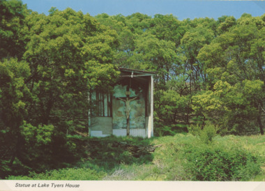
Photograph - Lake Tyers House, NU Color Vve, 1970c
Postcard was Produced for sale by Lake Tyers Scenic Boat TripsColour postcard of crucifix statue in grotto surrounded by scrub and timber Lake Tyers House Lake Tyers VictoriaStatue at Lake Tyers Housejetties, waterways -
 Lakes Entrance Historical Society
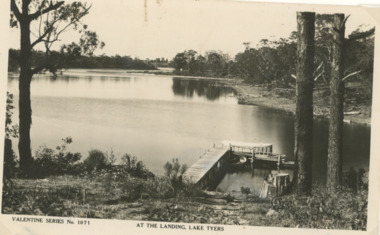
Postcard - Lake Tyers, Valentine Series 1071, 1950c
Also a colour postcard from same viewpoint at a later date taken by Viewpoint Productions purchased from B Roche number 03828.1 size 9 x 13.5 cmBlack and white postcard of tourist launch at jetty Fishermans Landing Lake Tyers VictoriaValentine Series No 1071 At the Landing Lake Tyersboats and boating, forest, waterways -
 Lakes Entrance Historical Society
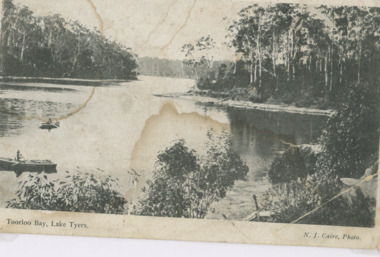
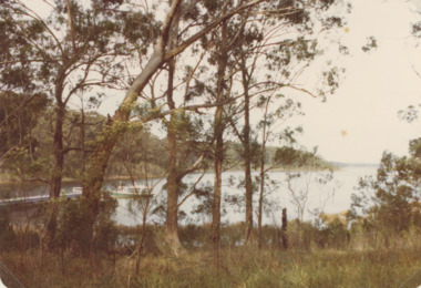
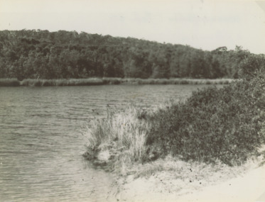
Photograph - Toorloo Bay Lake Tyers Victoria
Advertisement on back for Sale Steamboat Co LtdBlack and white photograph showing heavily forested shorelines, two small rowing boats left foreground Toorloo Bay Lake Tyers VictoriaToorloo Bay Lake Tyerswaterways, topography, gippsland lakes -
 Lakes Entrance Historical Society
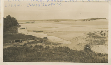
Photograph - Lake Tyers
Second similar image plus six small photographs taken of Lake Tyers 03825.1, 03825.2, 03825.3, 03825.4, 03825.5, 03825.6, 03825.7 size 6 x 8.5 cmBlack and white photograph of Cross's Landing showing lake, shoreline with frames for fishing nets small boat on sand, jetty beyond track to lake edge Lake Tyers VictoriaLake Tyers where lake is near the ocean Crossforest, waterways -
 Lakes Entrance Historical Society
Photograph - Lake Tyers, 1925c
Also a black and white photograph of tourist launch on Lake Tyers number 03824.1 size 10 x 15 cm photograph dark with damage crease showingBlack and white photograph of two tourist launches and three rowing boats at the landing at Lake Tyers Victoriaboats and boating, forest, waterways -
 Lakes Entrance Historical Society
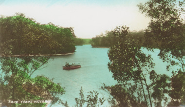
Photograph - Lake Tyers, Bulmer photography
Also two original postcards one tinted and one black and white numbers 03826.2 and 3826.3 size 6.5 x 10.5 cmTinted photograph of showing tourist boat possible Firefly on lake, thick forest around lake. Lake Tyers VictoriaLake Tyers Victoriaboats and boating, waterways -
 Lakes Entrance Historical Society
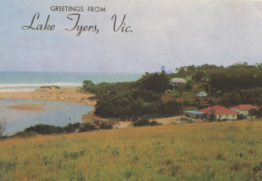
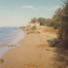
Postcard - Lake Tyers
Colour Photograph of Lake Tyers Beach and Kiosk, many people on the beach Greetings from Lake Tyers Vicboats and boating, forest, waterways, jetties, beaches -
 Lakes Entrance Historical Society
Photograph - Lake Tyers, 1970c
Colour photograph showing tourist launch at jetty tall trees in foreground Fishermans Landing Lake Tyers Victoriaboats and boating, forest, waterways -
 Lakes Entrance Historical Society
Postcard - Albert Park Lake Tyers, 1910c
Note on back to Miss Barber from Betty saying she asked Mrs Blay about accommodation etc. Also another postcard 03833.2 to a Clarence Pawsey dated 18.3.1918Sepia toned postcard showing Albert Park Guest House consisting of bedroom wing on left and detached kitchen dining wing on right, verandah across front of building with two deck chairs and bench on verandah, man and lady standing and lady sitting on bench. Extensive paths and garden in front, glimpses of other buildings at back. Two water tanks at left one round galvanized and one square, trees behind building. Lake Tyers VictoriaAlbert Park Lake Tyers Victoriawaterways, topography, guesthouses -
 Lakes Entrance Historical Society
Photograph - Lake Tyers, Marie Fish, 1978
Two other colour photographs taken of damage from storms June/July 1978 showing that sand dune between lake and ocean was swept away, road and toilet block undermined numbers 03831.1 and 3831.2 size 9 x 8.5 cmColour photographs showing damage to shore and track to entrance at Lake Tyers Beach Victoriabeaches, waterways -
 Lakes Entrance Historical Society
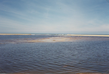
Photograph - Lake Tyers, M Holding, 1/06/1998 12:00:00 AM
Second colour photograph similar view number 03836.1 size 10x15 cmColour photograph taken after Lake Tyers has broken through the dunes to the sea showing surf breaking on the entrance Lake Tyers Victoria tourism, waterways, beaches -
 Lakes Entrance Historical Society
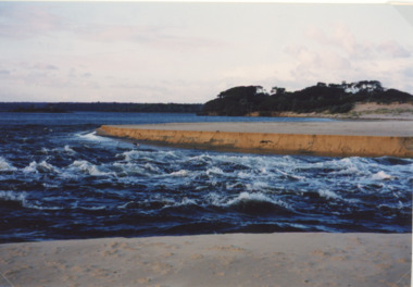
Photograph - Lake Tyers, Lakes Post Newspaper, 1/08/2001 12:00:00 AM
Colour photograph showing turbulant water at the new entrance at Lake Tyers showing western barrier of the lake in background and sand dune in foreground being washed away Lake Tyers Victoriawaterways, beaches -
 Lakes Entrance Historical Society
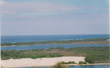
Photograph - Red Bluff, 1992
Colour photograph taken from the base at the Red Bluff looking to the south east shows low shrubbery on higher elevation above sandy beach, surf breaking with ocean beyond Lake Tyers Victoriaocean, waterways, sand dunes -
 Lakes Entrance Historical Society
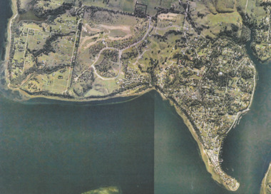
Photograph - Metung, Gippsland Ports, 2006 c
Colour aerial photograph showing Shaving Point at Metung including Chinamans Creek at the right housing subdivisions of Kingscove Estate Tambo Bluff Estate and Lake King on Gippsland Lakes Victoriaaerial photograph, topography, waterways, metung -
 Lakes Entrance Historical Society
Photograph - Jemmys Point Lakes Entrance, Tidy Town Committee, 1996 c
Also a second similar photograph number 03875.1 size 10 x 15 cmColour photograph taken from Jemmys Point looking west through the Gippsland Lakes to Metung with Rigby, Fraser and Flannagan Islands to the south Kalimna Victoriaaerial photograph, township, topography, waterways, jemmys point lakes entrance -
 Lakes Entrance Historical Society
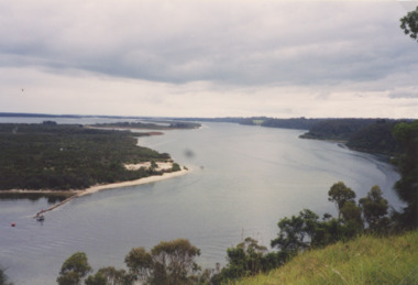
Photograph - Lakes Entrance, M Holding, 1/03/2004 12:00:00 AM
Colour photograph taken from Kalimna viewing platform from Rigby to outer barrier and Bass Strait beyond, East Gippsland Victoriawaterways, lakes entrance -
 Lakes Entrance Historical Society
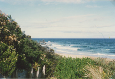
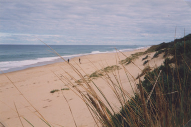
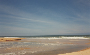
Photograph - Ocean Beach, Lakes Post Newspaper, 1/06/2000 12:00:00 AM
Colour photograph taken from Eastern Beach looking towards the west showing expanse of sand between calm ocean and shrub covered coastal dunes, two people on sand Lakes Entrance Victoriacoast, ocean, waterways -
 Lakes Entrance Historical Society
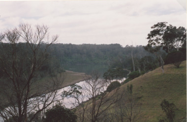
Photograph - Lake Bunga, Marie Fish, 1990c
Colour photograph taken from Western shore looking upstream showing heavily timbered banks Lake Bunga Victoriabridges, forest, historic site, waterways -
 Lakes Entrance Historical Society
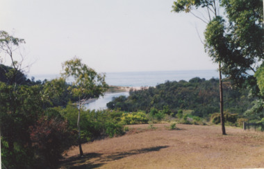
Photograph, Lake Bunga Victoria
taken from 'Bunga Haven' looking toward the closed entrance with ocean in the background Colour Photograph of Lake Bunga Victoria. Second photo of Lake Bunga waterways, topography, gippsland lakes -
 Lakes Entrance Historical Society
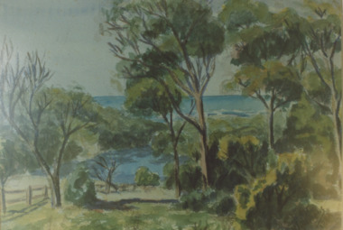
Photograph - Lake Bunga, 1980c
Colour photograph of a painting by Rodney Symmonds showing lake between overhanging trees with ocean beyond, Lake Bunga Victoriatopography, waterways, forest -
 Lakes Entrance Historical Society
Photograph - Lake Bunga, 1947
Also another black and white photograph number 03842.1 size 8 x 10.5 cm Black and white photograph showing Eastern shore with heavily timbered background taken from Western shore Lake Bunga Victorialake bunga, waterways, forest, vegetation -
 Lakes Entrance Historical Society
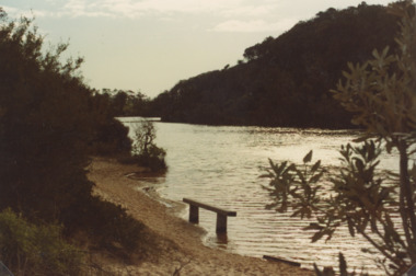
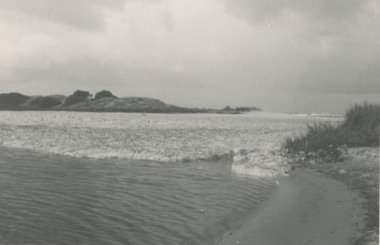
Photograph - Lake Bunga, M Holding, 1/06/1998 12:00:00 AM
Also a second coloured photograph showing expanse of sand on western shore with Mrs Glad Scarce seated on fence looking at open entrance Lake Bunga number 03849.1 size 10 x 15 cmColour photograph of the open entrance after an unusual weather condition Lake Bunga Victoriawaterways, lake bunga -
 Lakes Entrance Historical Society
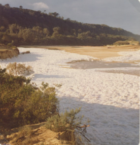
Photograph - Lake Bunga, Marie Fish, 1987c
Also three other colour phoptographs of foam at entrance and on lake after severe storm in June July 1978 numbers 03847.1, 03847.2, 03847.3 size 9 x 8.5 cmColour photograph showing foam across the open entrance after a severe storm, timbered hill in distance, Lake Bunga Victoriatopography, waterways -
 Lakes Entrance Historical Society
Photograph, Lake Bunga and ocean Victoria
Taken after a recent flood event. The ocean waters foam when it meets fresh water. Black and white photograph of the entrance to Lake Bunga Victoriaocean, waterways -
 Lakes Entrance Historical Society
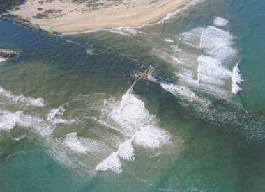
Photograph - Boat Harbour, Gippsland Ports, dredge April Hamer Lakes Entrance, 2006
Colour aerial photograph of the Entrance from Bass Strait to the Gippsland Lakes showing rock entrance groynes, surf on beach, dredge April Hamer working in the channel Lakes Entrance Victoria. Also another copy size 15 x 19.5 cmwaterways, topography, beaches, ocean -
 Lakes Entrance Historical Society
Photograph - North Arm Lakes Entrance, M Holding, 2008
Also two other colour photographs taken from Holding property showing twists and turns of North Arm number 03862.1 and 03862.2 sizes 10 x 15 cmColour photograph of North Arm views from D and K Holdings property Hunters Lane looking NNE Lakes Entrance Victoria people, tourism, waterways, lakes entrance -
 Lakes Entrance Historical Society
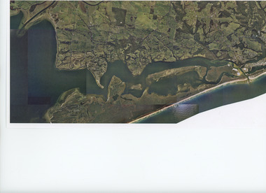
Photograph - Aerial view of Gippsland Lakes/Entrance to Tambo River, Gippsland Ports, 2006 c
Colour aerial photograph showing the entrance to Gippsland Lakes from Bass Strait westward to Reeves Channel Shaving Point at Metung through Lake King to Tambo River Gippsland Lakes Victoriaaerial photograph, waterways, township, topography, lakes entrance -
 Lakes Entrance Historical Society
Photograph - Lakes Entrance, Gippsland Ports, 2006 c
Second copyColour aerial photograph of entrance from Bass Strait to Gippsland Lakes including Bullock Island Reeves Channel Rigby Island houses on Kalimna Hill and Princes Highway winding down Jemmys Point hill into township of Lakes Entrance Victoriaaerial photograph, ocean, waterways