Showing 31906 items matching " south"
-
 Bendigo Historical Society Inc.
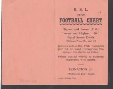
Document - R.S.L. BENDIGO COLLECTION: R.S.L. 1960 FOOTBALL CHART
Orange card titled R.S.L. 1960 Football Chart. On the front is how it works. Donation 2/-. Melbourne Sun Results. Printed by Arthur Hocking Print. On the other side is the list of the teams and the dates from 16/4/60 to 20/8/60. The Football clubs are: Melbourne, Sunshine, Geelong, Preston, Fitzroy, Box Hill, Richmond, Yarraville, South Melbourne, Oakleigh, St. Kilda, Brunswick, Hawthorn, Sandringham, Collingwood, Brighton, Footscray, Northcote, Moorabbin, Essendon, Coburg, North Melbourne, Camberwell, Carlton, Williamstown, Port Melbourne, Dandenong and Mordialloc.Arthyr Hocking Print.clubs and associations, football, football chart, r.s.l. bendigo collection - r.s.l. 1960 football chart, melbourne sun, arthur hocking print, melbourne, sunshine, geelong, preston, fitzroy, box hill, richmond, yarraville, south melbourne, oakleigh, st. kilda, brunswick, hawthorn, sandringham, collingwood, brighton, footscray, northcote, moorabbin, essendon, coburg, north melbourne, camberwell, carlton, williamstown, port melbourne, dandenong, mordialloc -
 Bendigo Historical Society Inc.
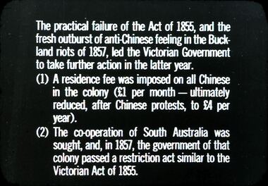
Slide - DIGGERS & MINING. THE CHINESE ON THE GOLD FIELDS, c1857
Diggers & Mining. The Chinese on the Gold Fields. Slide: The practical failure of the Act of 1856, and the fresh outburst of anti-Chinese feeling in the Buckland riots of 1857, led to Victorian Government to take further action in the latter year. (1) A residence fee was imposed on all Chinese in the colony (one pound per month - ultimately reduced, after Chinese protests, to four pound per year). (2) The co-operation of South Australia was sought, and , in 1857, the government of that colony passed a restriction act similar to the Victorian Act of 1855. Markings: 21. Used as a teaching aid.hanimounteducation, tertiary, goldfields -
 Bendigo Historical Society Inc.
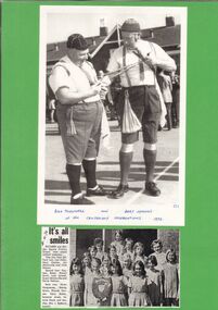
Newspaper - GOLDEN SQUARE P.S. LAUREL ST. 1189 COLLECTION: NEWSPAPER CUTTINGS
Green laminated card with two photos. The first is Bill Thirwell and Bert Symons at the Centenary Celebrations 1973. The second photo is the Golden Square Primary School Inter-school softball premiers. They are, from left, front row: Lisa Hollis, Kerry Clayton, Jan McConville, Vicki Robson. Second row: Kayleen Baker, Sharon South, Judy Latwell, Susan McConville, Kerrie Pattison. Back row: Karen Hargreaves, Wendy Nixon, Rhonda hansen, Kerry Sutton, Suzanne Jones, Leanne Doyle and teacher, Mrs J Raeburn,education, primary, golden square laurel st p.s., golden square primary school 1189 collection - newspaper cuttings, bill thirlwell, bert symons, centenary celebrations 1973, lisa hollis, kery clayton, jan mcconville, vicki robson, kayleen baker, sharon south, judy latwell, susan mcconville, kerrie pattison, karen hargreaves, wendy nixon, rhonda hansen, kerry sutton, suzanne jones, leanne doyle, mrs j raeburn -
 Tennis Australia
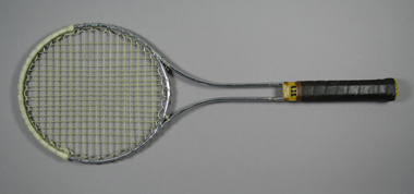
Racquet, Circa 1969
A Wilson 'T2000' metal tennis racquet, with double shaft; yellow plastic shaft casing & gold whipping. Handle wrapped with brown leather. Net anchored to metal wire wrapped around head frame. Yellow plastic butt cap with white label featuring 'W' logo in red. White plastic reinfrcement strip fixed around crown. Adhesive label inside shaft states: STRUNG WITH PRIDE & TLC/SOUTH COAST TENNIS & GOLF SHOPS. Materials: Metal, Plastic, Adhesive tape, Nylon, Adhesive label, String, Leathertennis -
 Kew Historical Society Inc
Plan - Subdivision Plan, Windella-Darnley Subdivision, Studley Park, 1920s
Subdivision plans are historically important documents used as evidence of the growth of suburbs in Australia. They frequently provide information about when the land was sold on which a built structure was subsequently constructed as well as evidence relating to surveyors and real estate and financial agents. The numerous subdivision plans in the Kew Historical Society's collection represent working documents, ranging from the initial sketches made in planning a subdivision to printed plans on which auctioneers or agents listed the prices for which individual lots were sold. In a number of cases, the reverse of a subdivision plan in the collection includes a photograph of a house that was also for sale by the agent. These photographs provide significant heritage information relating house design and decoration, fencing and household gardens.Version 1 of two subdivision plans (the later one is MAP.0027) for the section of Studley Park Road near the Junction on the south side. Named in the subdivision are the mansions of Darley and Windella (now demolished). Before the subdivision of Darley and Windella, both houses fronted Studley Park Road. Both houses appear to be advertised as lots in the subdivision. Bisecting the subdivision is a street, Antrim Avenue that was never constructed. A street, which was subsequently constructed in this vicinity, was Merrion Place, which now runs between Studley Park Road and Highfield Grove. There are 14 proposed lots in this subdivision."Antrim Avenue. See over for new plan"subdivision plans - kew, studley park, windella, darnley, studley park road -- kew (vic.), merrion place -- kew (vic.), merrion grove -- kew (vic.), highbury grove -- kew (vic.) -
 Kew Historical Society Inc
Plan - Subdivision Plan, Plan of Subdivision of Crown Portion 71, Parish of Boroondara LP12509, Vol.1678, Fol.335526, Before 1930
Prue Sanderson, in her groundbreaking ‘City of Kew Urban Conservation Study : Volume 2 - Development History’ (1988), summarised the periods of urban development and subdivisions of land in Kew. The periods that she identified included 1845-1880, 1880-1893, 1893-1921, 1921-1933, 1933-1943, and Post-War Development. These periods were selected as they represented periods of rapid growth or decline in urban development. An obvious starting point for Sanderson’s groupings involved population growth and the associated economic cycles. These cycles also highlighted urban expansion onto land that was predominantly rural, although in other cases it represented the decline and breakup of large estates. A number of the plans in the Kew Historical Society’s collection can also be found in other collections, such as those of the State Library of Victoria and the Boroondara Library Service. A number are however unique to the collection.Subdivision plans are historically important documents used as evidence of the growth of suburbs in Australia. They frequently provide information about when the land was sold on which a built structure was subsequently constructed as well as evidence relating to surveyors and real estate and financial agents. The numerous subdivision plans in the Kew Historical Society's collection represent working documents, ranging from the initial sketches made in planning a subdivision to printed plans on which auctioneers or agents listed the prices for which individual lots were sold. In a number of cases, the reverse of a subdivision plan in the collection includes a photograph of a house that was also for sale by the agent. These photographs provide significant heritage information relating house design and decoration, fencing and household gardens.The six lots on the south side of Macartney Avenue, between Macartney Avenue and Daniell Place were part of a subdivision that occurred before 1930. The subdivision plan is of interest in that the original name of Daniell Place was Brougham Place. On the Plan, it is noted that lots 5 and 6 (currently 10 and 12 Macartney Avenue) had been sold for £13 each. By November 1930, the new six-roomed villa built on 12 Macartney Avenue was offered for immediate sale at a ‘sacrifice price’. Any offer in reason would be considered, although a £350 deposit was required.subdivision plans - kew, mount street - kew, brougham street - kew , macartney avenue - kew -
 Kew Historical Society Inc
Map, MMBW, MMBW Town of Kew, 1910-21
The Melbourne and Metropolitan Board of Works (MMBW) was established by an act of the Victorian Parliament in 1890 to prepare for and to implement a sewerage and water reticulation system across what was then inner Melbourne, its surrounding and middle distance suburbs, including Kew. The MMBW was disbanded in 1991.The map collection of the Kew Historical Society has at its core the historic maps assembled and originally stored in the City Engineer's Department of the City of Kew. These include maps in a number of scales. The vast majority of maps were produced by the MMBW in the first two decades of the twentieth century, and are solid working maps, backed by linen for durability. These maps are historically significant to Kew, the City of Boroondara and to the history of the development of state utilities in Victoria. A number of the Kew maps have additional details added by former municipal officers, including the levels reached by various floods. As these were working documents, information was added to them long after the period of their initial production and distribution.Early map of the Town of Kew, created after 1910, at a scale 440 ft to 1 inch. The 'assembled' map by the City of Kew Engineer's Department includes scaled down copies of The Melbourne and Metropolitan Board of Works maps, Nos. 39, 40, 64, 65, 66, 67, 68, and 117. The map covers the entirety of the Town of Kew, bordered on its north and west by the River Yarra, by Burke Road in the East and Barkers Road in the south. The map shows the extent of urban development by that time, prominent institutions and the outlines of built structures in the municipality. TOWN OF KEW / SCALE 400 FEET TO 1 INCHmelbourne & metropolitan board of works, mmbw maps, mmbw plans, town of kew, cartography -
 Beechworth Honey Archive
Hand-Written Copy of Particulars and Conditions of Sale of Land May 1922
This item consists of two pages. Page One: Hand-written copy of a Particulars and Conditions of Sale of Land for a piece of land in Moira county (East of Goulburn River, South of Murray River, West of Ovens River). Also inculded is a hand-written copy of a Particulars and Conditions of a Contract of Sale; Frank L. Frost is selling land to Bridget Ellen Ryan. Takes place in May 1922. Copy of Transfer of Land Title. Purchase price £478.11.3 Page Two: A list of Parish, Shire and County locations. Both pages written with black ink on paper. hand written, hand-written, particulars, conditions, sale, land, title, parish, shire, county, ryan, frost, beekeeper, beechworth honey -
 Surrey Hills Historical Society Collection
Photograph, 5 York Street, Mont Albert, May 1985 (1), 1985
This is the home of Ernest Augustus Young (1891-1985) and Ruby Nichell Whitby (1892-1984) and their son Ernest Lance Young. Lance was born 24 March 1915 in Surrey Hills; after he married Beryl Mair. Electoral roll for 1937 gives the house name as 'Whitby Lodge'. Ernest and Ruby also had twins Clive and James who died in infancy. Buried at Box Hill Cemetery - M-*-0867 (family plot) This is part of a large collection relating to the Mair, Deakin and Young families. REF: Memoir of Laurie Newton (nee Young) - Her grandfather bought the land and had the house built. She remembers it as having pressed ceilings in some rooms and ornate fireplaces and tiles and leadlight windows in some rooms and doors with leadlight panels. Her grandfather was a keen gardener with an ornamental front garden and many vegetables and fruit trees in the back yard. Her grandfather sold the adjoining block (No 3 York Street), which had been used for growing flowers and vegetables, to John and Edna Jean. Reid. She also remembered that he extended the house and divided it into 2 flats, renting out the northern side for 20 years. Sold by Jellis Craig on 24 December 2010 - With formal living, dining, 3 bedrooms, 2 bathrooms, garage/ample OSP. Land: 18.2m x 40.8m (60' x 134') approx. Large 2 storey house replaced the house.Colour photo of the street view of 5 York Street, Mont Albert. The house is Edwardian in style, constructed from weatherboard painted white with a red corrugated iron roof with simple finials. There is a small veranda with simple fretwork, lead-light feature windows to one, possibly two front rooms, one of which has a bay window. There is a garage set back at the side of the house with a concrete driveway on the south side of the house towards Mont Albert Road. The fence is low and constructed from roughly faced stone. The garden contains mature shrubs.In blue biro on rear: "1985 / POP'S" ; "5 YORK ST / E.A. YOUNG". Red photographic processing stamp "PROCESSED BY / KODAK / MAY 85M"ernest augustus young, ruby nichell whitby, ruby nichell young, ernest lance young, box hill cemetery, whitby lodge, house names, mont albert -
 Royal District Nursing Service (now known as Bolton Clarke)
Photograph - Document/Letter, 1900
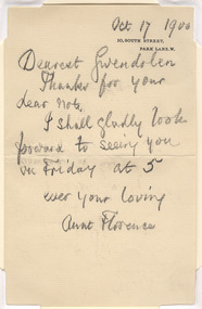
A letter dated 8th May 1973 details how the letter from Florence Nightingale was forwarded to Mrs E.G. (Janet) Wilson in 1955 by Gwendolen, Florence Nightingale's niece. The explanatory letter was forwarded by Elsa Halenstein and given to Royal District Nursing Service and remains in its Archives. From 1948 Mrs. Wilson served on the Committee of Management of Melbourne District Nursing Society (later Service), serving as President from October 1964-1967. In 1949 Mrs. Hallenstein served on the MDNS Committee of Management, becoming President of the now Royal District Nursing Service from 1967-1974. Florence Nightingale was the founder of modern nursing. Melbourne District Nursing Society (MDNS) only employed Trained nurses from its inception in 1885. They followed Florence Nightingale's basic rules of good hygiene, cleanliness, good nutrition and fresh air, which they learned during their Nursing Training at a Hospital, and taught to their patients by instruction and demonstration. In those days Trained nurses were called 'Nurse'. In 1892 MDNS employed Lucy Smith who, through the Nightingale Fund, did her nursing training at the Nightingale Training School at St. Thomas's Hospital in London. She was the first nurse from this school to work at MDNS. Florence Nightingale, born on the 12th of May 1820, was named after the place of her birth in Italy. Born into a wealthy family she was schooled at home where she excelled in her studies; spoke several languages fluently, and was taught home management. She believed she was ‘called’ to reduce human suffering and tended to ill members of her family and tenants on the family estate. She worked as a nurse at Salisbury Infirmary where she learned about nursing sanitation and hospital practice. Florence then enrolled at the Institution of Protestant Deaconesses at Kaiserswerth, Germany where she learned basic nursing skills, the importance of patient observation, and hospital organization. In 1853 she became Superintendent of the Institution for Sick Gentlewomen in Distressed Circumstances in London, where she reformed health care, working conditions, and hospital efficiency. The Crimean War broke out in late 1853 and a newspaper reported the injured and sick soldiers were being cared for by an “incompetent and ineffective medical establishment and that most basic supplies were not available for care”. After an outcry from the public, Florence was asked to lead a group of 38 nurses, whom she had trained, to Scutari where the wounded soldiers were sent. After arriving at the Barrack Hospital in October 1854, she found the soldiers were being cared for in overcrowded and filthy conditions; contaminated water, faeces on the floors and rats running freely. There were few supplies and equipment. Florence bought supplies and equipment and found help to assist in the laundry. The wards were scrubbed from floor to ceiling. Florence set a high standard of care with fresh air, hygiene, clean clothing, sufficient food and regular dressing of wounds being carried out. She realized the importance of psychological needs, and soldiers were assisted to write letters to relatives, and took part in education and recreational activities. Of a night Florence walked through the wards, carrying a lamp to light her way, to check on ill and wounded soldiers and became known as “The Lady with the Lamp”. She gained the respect of the soldiers and the establishment, and later, the public through the soldier’s letters and reports in the newspaper. After visiting Crimea she contracted ‘Crimean Fever’ from which she never really recovered. When she returned to London she was regarded a heroine. The public had given freely to buy her a gift but Florence preferred this money be used to establish a fund, which became known as the Nightingale Fund. Florence had kept excellent records on the running of the Barrack Hospital, medical and nursing staff efficiency, and the causes of illness and death. Many nurses from the training school became Matrons in many countries throughout the world. Florence pushed the Government for legislation to improve drainage and sanitation in homes and in the building of hospitals with fresh air a priority. She wrote the book ‘Notes on Nursing’ and many writings on health reform. She died, aged 90 years, in her home at 10 South Street, Park Lane on the 13th of August 1910. A handwritten letter, written in lead pencil, by Florence Nightingale. It is written to her niece Gwendolen.. The letter is on buff coloured paper and has the date 'Oct 17 1900'/ written in the top right hand corner; below this is, in capital letters, the two line black printed address - '10, South Street,/ Park Lane, W'/ is stamped. The bulk of the letter reads over eight lines: "Dearest Gwendolen",/ "Thanks for your / dear note,/ I shall gladly look / forward to seeing you, / on Friday at 5 ,/ ever your loving, / Aunt Florence./ . rdns, royal district nursing service, miss florence nightingale, mrs e.g. (janet) wilson, mrs d. (elsa) hallenstein -
![Map, Plan of Town Allotments Bacchus Marsh [1891-1897]](/media/collectors/5e461d8021ea67224c82f2a1/items/66acc1c90c778f9f64a3daec/item-media/66acc3990c778f9f64a3e09b/item-fit-380x285.jpg) Bacchus Marsh & District Historical Society
Bacchus Marsh & District Historical SocietyMap, Plan of Town Allotments Bacchus Marsh [1891-1897]
This plan of town allotments in Lerderderg Street and Bennett Street also includes the location of many of the buildings, shops, businesses and houses which were present in the retail and business area of Bacchus Marsh in the 1890s. The precise date of the plan is not known but it must be sometime between 1891 and 1897. The Post Office and the Wesleyan Church are both shown on this plan. Both of these were constructed in 1890. The plan does not show the Baptist Church in Main Street which was constructed in 1898. Hence the date is sometime between 1891 and 1897.This plan of Bacchus Marsh is one of the most detailed visual representations of the location of shops, businesses and houses in the central part of Bacchus Marsh. It provides very precise locations of most of the shops and houses in the town in the 1890s. A single page paper plan showing allotments of land fronting Lerderderg and Bennett Street. Buildings, businesses and houses along most of the streets are identified by hand written annotations. Streets identified on plan: Lerderderg Street - Bennett Street - Main Street - Gell Street - Young Street - Graham Street. Physical boundaries of the map are: North border - Lerderderg Street - South border - Main Street - West border Gell Street - East border - Young Street. The plan is pasted into a bound volume containing 76 maps or plans in total. bacchus marsh victoria maps, shops bacchus marsh -
 Mont De Lancey
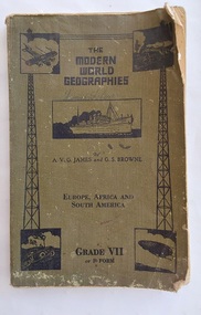
Book, The Specialty Press Pty. Ltd. et al, The Modern World Geographies Grade VII or F Form, c 1938
The Modern World Geographies: Europe, Africa and South America Grade VII or Form F is part of a series of six little books of geographical information for children between the ages of eight and fourteen written by very experienced teachers and educationalists. They are readers rather than textbooks with the object of stimulating interest and to leave to the teacher the filling in of the course by appropriate lessons.A faded khaki green softcover reader or textbook with black lettering on the front cover at the top for the title The Modern World Geographies, Europe, Africa and South America Grade VII or Form F. A black and white illustration of a steamship and four other pictures are printed on the damaged front cover. Throughout are black and white charts, maps, diagrams, photographs and illustrations. In red ink writing inside on the front endpaper is Lance Sebire. Dog eared pages with a damaged worn cover and stains. Lance Sebire is written again on the back cover.226p.non-fictionThe Modern World Geographies: Europe, Africa and South America Grade VII or Form F is part of a series of six little books of geographical information for children between the ages of eight and fourteen written by very experienced teachers and educationalists. They are readers rather than textbooks with the object of stimulating interest and to leave to the teacher the filling in of the course by appropriate lessons.children's books, readers, geography, textbooks -
 Wodonga & District Historical Society Inc
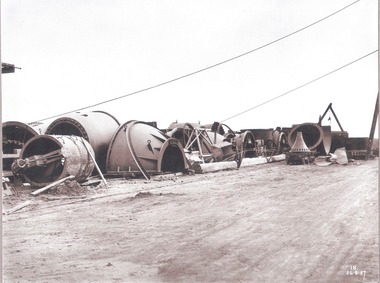
Album - Hume Reservoir Australia Album - Needle valves, August 1927
This set of photos is from a leather bound album bearing the inscription "HUME RESERVOIR AUSTRALIA" plus 'The Rt. Hon. L. C. M. S. Amery, P. C., M .P.' all inscribed in gold. It was presented to The Rt. Hon. L. C. M. S. Amery, P. C., M. P, Secretary of State for Dominion Affairs on the occasion of his visit to the Hume Reservoir on 2nd November 1927. This album is of local and national significance as it documents the planning and development of the Hume Reservoir up to 1927. It was the largest water reservoir in the British Empire. The album records the pioneering engineering work that went into its construction.DEPARTMENT OF PUBLIC WORKS, N.S.W. RIVER MURRAY WATERS SCHEME. HUME RESERVOIR. 34. Needle Valves. Some of the needle valves in parts stacked ready for removal by the cableway to their positions on the outlets. There are seven of these, 7 feet 6 inches in diameter. The heaviest single part weighs about 10 tons. New South Wales. August 1927. A needle valve is a type of valve which can be used to regulate flow of a substance, usually either gas or water, through an appliance or system. The unique feature of the value is the inclusion of a small plunger, with a shape akin to a needle.hume reservoir australia, river murray waters scheme, hume reservoir construction -
 Wodonga & District Historical Society Inc
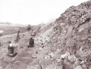
Album - Hume Reservoir Australia Album - View along the face of the quarry, August 1927
This set of photos is from a leather bound album bearing the inscription "HUME RESERVOIR AUSTRALIA" plus 'The Rt. Hon. L. C. M. S. Amery, P. C., M .P.' all inscribed in gold. It was presented to The Rt. Hon. L. C. M. S. Amery, P. C., M. P, Secretary of State for Dominion Affairs on the occasion of his visit to the Hume Reservoir on 2nd November 1927. This album is of local and national significance as it documents the planning and development of the Hume Reservoir up to 1927. It was the largest water reservoir in the British Empire. The album records the pioneering engineering work that went into its construction.DEPARTMENT OF PUBLIC WORKS, N.S.W. RIVER MURRAY WATERS SCHEME. HUME RESERVOIR. 35. Quarry. View along the face of the quarry. Granite is being quarried here for the concrete material. Blocks from 2-8 tons in weight are reserved for “plums”. Quantities of large size spalls are sent to Victoria for the toe of the embankment and other purposes but the greatest proportion of the stone is crushed at the quarry to 2½ inches gauge for concrete aggregate. Two steam navvies and two steam travelling cranes are at work on the face. New South Wales. August 1927.hume reservoir australia, river murray waters scheme, hume reservoir construction -
 Bendigo Historical Society Inc.
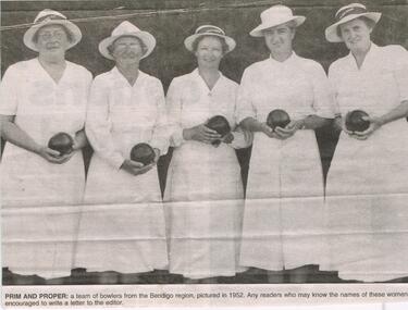
Newspaper - JENNY FOLEY COLLECTION: PRIM AND PROPER
Bendigo Advertiser ''The way we were'' from 2003. Prim and proper: a team of bowlers from the Bendigo region pictured in 1952. Bendigo Advertiser ''The way we were'' from 2003. Identified: the women are picture at a Bendigo and District Ladies Bowls Association Champion of Champions event on March 3, 1952. They are Miss Okey (Kangaroo Flat) Mrs. Wallace (white Hills), Mrs. Jenkins (South Bendigo), Mrs. Olive Body (East Bendigo) and Mrs. Strode (Golden Square). The winner of the Champions of Champion was Mrs. Jenkins. The clip is in a folder.newspaper, bendigo advertiser, the way we were -
 Bendigo Historical Society Inc.
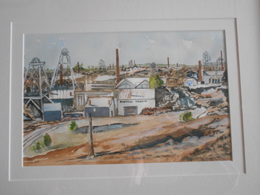
Painting - JOHN HALL COLLECTION: DEVONSHIRE GROUP OF MINES
BHS CollectionWatercolour by John Hall. Gold frame, cream mount board. Painting shows a minescape with many poppet heads and chimneys in middleground. Mine building in foreground has 'Duchess Tribute' written on side of shed. Mine dam in immediate foreground in front of mine buildings. On back of frame, written on copy of image that painting was taken from: 'Devonshire Group of Mines, Snob's Hill and Mungo Mines in background. Written across bottom from LH side ' Duchess Tribute, West United Devonshire, Phoenix, Duchess of Edinburgh, United Devonshire, South Devonshire.'John Hall, Eaglehawkbendigo, mining, duchess tribute -
 Bendigo Historical Society Inc.
Photograph - SOUTH NEW MOON MINE - EAGLEHAWK, 1935
2 Photographs on a folded board. One black and white, one sepia. Both photographs of South New Moon Mine, Eaglehawk, taken from 2 different views. Written on board around the photos. Gold yield 257.498 ozs. Dividends $ 1.106.560.00. Leading mine on field 1901-05. Leading mine in state 1903. Operated 1871 to 1920's. Revived 1933 to 1941. The sepia photo on right side of cardboard says, 'Above photo taken 1935.' Written on back of one photo, A.Richardson, 29 Harrison Street, Bendigo.'eaglehawk, mine - south new moon., olive pell collection. south new moon mine -
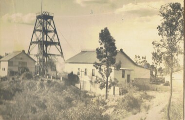
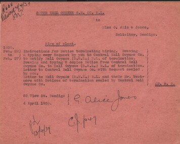 Bendigo Historical Society Inc.
Document - MISS G ALICE JONES COLLECTION: ACCOUNT
Pink paper headed South Nell Gwynne G.M. Co. N.L. to Miss G. Alice Jones. Dated Feb. 22 to Feb. 27, 1939, and 4 April 1939. Letter refers to sending letters re termination of hiring plant. Typing letters from Central Nell Gwynne Co. to Nell Gwynne (B.M.L.) Cost £2.2.0. Pd. 13/4/39 written at the end. R668 Delivered 4/4/39 written in the top left corner. Information re G. Alice Jones attached to record.bendigo, business, g. alice jones solicitor, the miss g. alice jones collection - account, south nell gwynne g.m. co. n.l., central nell gwynne co., nell gwynne (b.m.l.) n.l., mr westmore -
 Ballarat Tramway Museum
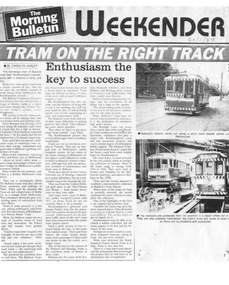
Document - Photocopy, "Tram on the Right Track / Enthusiasm the key to success", c1989
A3 size sheet photocopy of an item that appeared in the Rockhampton Morning Bulletin on 28/1/1989 about the work done by the Ballarat Tramway Preservation Society. Article by Carolyn Varley of Rockhampton, discussing her visit to Ballarat and the work being done by the people in Rockhampton for the restoration of the Purrey Steam Tram at the same time. At time of interview, driver or motorman for the BTPS was Peter Winspur and Conductor Chris Jacobson. Has two photos, one of 14 heading south to Carlton St and the other in the depot with 33 on jacks on 5 road and 40 stored on 4 road.trams, tramways, btps, volunteers, rockhampton, purrey steam tram -
 Melbourne Tram Museum
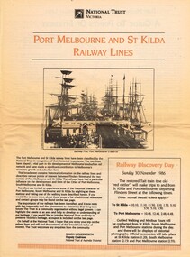
Newspaper, National Trust, "Port Melbourne and St Kilda Railway Lines" - Rail Discovery Day - Sunday 20 November 1986", Nov. 1986
Newspaper - four sheets printed on newsprint - National Trust Victoria - titled "Port Melbourne and St Kilda Railway Lines" - Rail Discovery Day - Sunday 20 November 1986", featuring photos and information about the two lines, that at the time was facing closure and conversion to Light Rail. Notes the National Trust had classified the lines. Gives points of interest along the lines, walks through St Kilda, South Melbourne and Port Melbourne. Gives the times for the use of a Tait or sliding door train on both lines from Flinders St stationtrams, tramways, port melbourne, st kilda, light rail, conversion, national trust, railways -
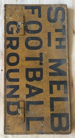 Melbourne Tram Museum
Sign, Melbourne & Metropolitan Tramways Board (MMTB), "Fitzroy Football Ground", "Sth Melb Football Ground", 1950's
Sign, painted onto a MMTB auxiliary destination board of the type that could hang on the front of a Melbourne tram car with the words "Fitzroy Football Ground" and "Sth Melb Football Ground" Black letters on a yellow background. The bottom right hand corner of the Sth Melbourne face has the letters "E.P." indicating the depot that it belonged to - East Preston. South Melbourne Football Ground Metal sign, fitted with metal hanging brackets, riveted to sign on both sides. Manufactured by rolling the outer edges over a 4mm diameter steel rod.trams, tramways, football, fitzroy, south melbourne, signs, auxiliary board -
 Melbourne Tram Museum
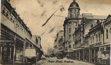
Postcard, Valentine's, "Chapel St, Prahran", c1915
Postcard - photo of Chapel St Prahran looking south along Chapel St towards the intersection with Commercial Road with the Jacob Read drapery business or the Charles Moore and Company department store - now the Pran Central complex in the view. Has a number of horse drawn vehicles, some motor cars and a cable tram in the view. Divided back with spaces for Correspondence, address and stamp. Stamp area has "Printed in county of Saxony" and number 3949 in bottom right hand corner. Published by Valentines & Sons Publishing Co. Melbourne and Sydney.trams, tramways, cable trams, commercial rd, malvern rd, chapel st, horse drawn vehicle -
 Melbourne Tram Museum
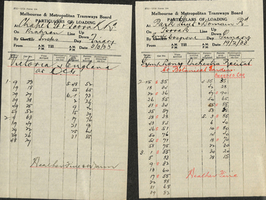
Document - Form/s, Melbourne & Metropolitan Tramways Board (MMTB), "Particulars of Loading", 1933
Form 104 - titled "Particulars of Loading" - giving tramcar passenger capacity, location, date, counted by, time, tram number, destination, and passengers. 1. - Prahran line. At Chapel St & Toorak Rd. Dated 10 & 11/2/33. Cricket - Victoria v South Australia 2. - Toorak line. At Park St & Domain Rd. Dated 19/2/33. Symphony orchestra recital at Botanical Gardens 3. - Prahran line. At Chapel St & Toorak Rd. Dated 3/3/33. Cricket - Victoria v England at MCGtrams, tramways, mmtb, tramcars, passenger services, inspectors, reports -
 Melbourne Tram Museum
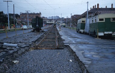
Slide, Keith Kings, 12/09/1959 12:00:00 AM
Colour slide, Kodak, fawn cardboard of track laying for the new South Melbourne / St Kilda Beach terminus in Park St, for the closing of the section of track into Mary St and Beaconsfield Parade. Has an early tracked excavator, parked on the road that has been broken up. Shows new track laid on timber sleepers with former wartime Austerity buses along side the road. Photo taken at the corner of Mary St 12/9/1959. Preliminary overhead work has been undertaken. Slide Number K(c)(292)Extensive handwriting on rear in ink and that it was photographed at 1/60 at f4.5.trams, tramways, st kilda, mary st, beaconsfield parade, south melbourne, new track, park st st kilda -
 Melbourne Tram Museum
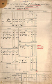
Document - Report, Tramway Board, "Return of fuel & Oil used at ...... Power House during the Month of November 1918", Nov. 1918
Set of reports for the "Return of fuel & Oil used at ...... Power House during the Month of November 1918", listing the amount and value of fuels, lubricants, bearing oil, road pulley lubricants, rope oil and rope tar for various cars houses. Prepared on a pre-printed form. Also lists the length of ropes and the average amounts per mile of rope. Form No.374, 7/17 Gives details for the following Power houses. Richmond Fitzroy Brunswick Johnston St North Carlton St Kilda Esplanade Prahran North Melbourne South Melbournetrams, tramways, cable trams, reports, winding houses, power house, richmond, fitzroy, brunswick, johnston st, north carlton, st kilda, esplanade, prahran, north melbourne, south melbourne -
 Melbourne Tram Museum
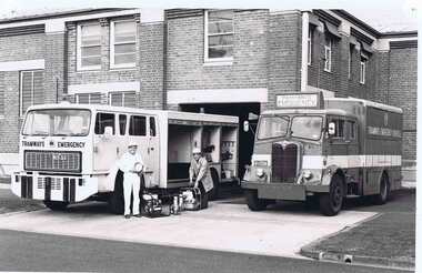
Photograph - Black & White Photograph/s, Melbourne & Metropolitan Tramways Board (MMTB), 1979
Black and white photograph of the "new" and "old" tramway emergency vehicles side by side at South Melbourne depot - would appear the new vehicle is being fitted out and equipment possibly being transferred. Shows the registration numbers of the vehicle. These are known by their radio call signs R10. See Winter 1981 Metra News for the story behind the photo - Reg Item 1026.5 Reference added 17-9-2015. See also Reg Item 2528 for another photo, possibly done at the same time and 6731 for a photo without people of equipment.trams, tramways, emergency, recovery, mmtb, r10 vehicle, aec, south melbourne depot -
 Melbourne Tram Museum
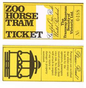
Ephemera - Ticket/s, Tramway Museum Society of Victoria (TMSV), "Zoo Horse Tram", 1975
Set of 8 "Zoo Horse Tram" tickets, used by the TMSV initially for their operation at South Melbourne loop in 1975, then at Bylands prior to electric trams commencing. Printed on yellow card with black printing and black ticket number. Has the conditions of travel and the TMSV logo on the rear. The child tickets have been hand stamped "CHILD" (blue ink) onto the right half. Has the letter 1 in white on the front. Adult tickets - Nos. 0118, 488 and 489. Child tickets - Nos. 0675, 0676, 9648, 9649, 9692, 9693.trams, tramways, tickets, tmsv, zoo tram, bylands, south melbourne loop -
 Ballarat Tramway Museum
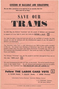
Pamphlet, E R Courtney as Secretary of the Tramway Employees Association Ballarat Division, "Save our trams", May. 1970
Yields information about the local union branch promoting the ALP at the 1970 State election and has a strong association with the Secretary of the branch.Pamphlet - printed on light brown or fawn paper, titled "Save our trams", promoting the Victorian Labor Party for the 30 May 1970 Election to defeat the Bolte Government and the closure of the tram service in Ballarat. Signed by E R Courtney as Secretary of the Tramway Employees Association Ballarat Division. Seeks the defeat of Messrs Byrne, Evans and Stephen. Labor party candidates were K Flynn (North), T Cullen (South) and J Jones (Province). The Parliamentary website - https://www.parliament.vic.gov.au/about/the-history-of-parliament/elections-since-1856 Bolte was returned as Premer.trams, tramways, closure, unions, alp, elections -
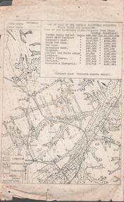 Bendigo Historical Society Inc.
Document - MINING REPORTS - MAP OF PART OF THE BENDIGO GOLDFIELD INCLUDING WHITE HILLS AND EAGLEHAWK
BHS CollectionMap of part of the Bendigo Goldfield including White Hills and Eaglehawk. Map shows reef lines, gullies, railway line, tram route, type of rock, name of mine, Calls and Dividends. Also Deepest Mine Victoria Quartz 4614 ft. Names of Mines are Garden Gully United, Great Ext'd Hustlers, Johnson's Reef, South New Moon, New Moon, Catherine Reef, Virginia, Central Red White & Blue, Ironbark, Kock's Pioneer, Carlisle and the Hercules & Energetic. Map is part of the Albert Richardson Collection of mining documents and research. document, gold, mining reports, mining reports, map of part of the bendigo goldfield including white hills and eaglehawk, pabst bendigo goldfield, garden gully united, great ext'd hustlers, johnson's reef, south new moon, new moon, catherine reef, virginia, central red white & blue, ironbark, kock's pioneer, carlisle, hercules & energetic. victoria quartz -
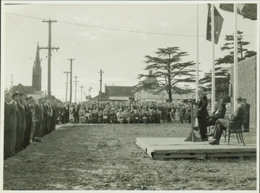 Kew Historical Society Inc
Photograph - Anzac Day Service in front of the Kew City Hall and World War II Memorial, 1960
The Kew City Hall, designed by the architect Harold Bartlett of Leith & Bartlett, was opened by The Premier The Hon HE Bolte on 23rd April 1960. At the time of the opening, Cr Ferguson was Mayor of Kew. Monochrome photograph of the annual Anzac Day service on the front lawn of the newly opened Kew City Hall in 1960. The Town Hall faced Cotham Road in front of which are standing returned soldiers. Invited seated and standing guests have their backs to Charles Street and the lawns of South Esk. The speaker would appear to be the Deputy Premier, and local Member for Kew Arthur Rylah MP. Behind the Official Party [but unseen] are the two Memorial plaques by George Henry Allen (1900–72). In the distance are the Kew Presbyterian Church and the Sacred Heart Church. Cr Ferguson / Anzac Day Service 1960kew city hall, city halls -- victoria, cr hugh ferguson, kew town hall, kew (vic.) -- civic buildings, anzac day services -- kew (vic.)