Showing 16861 items matching "h-way"
-
 Bendigo Historical Society Inc.
Map - HUSTLER'S REEF & HUSTLER'S REEF NO 1 MINES - PLAN OF THE HUSTLER'S REEF & HUSTLER'S REEF NO 1 MINES
Plan of the Hustler's Reef & Hustler's Reef No 1 Mines on the Hustler's Line of Reefs, Bendigo Bulletin No 33, Plate No XIV. No 8 connecting No 10 (Hustler's Reef), No 11 connecting No 13 (Hustler's Reef), No 13 (Hustler's Reef No 1) connecting No 15 (Hustler's Reef) and No 10 Hustler's Reef No 1 rise to Comet Mine. Map shows different levels in relation to the two shafts, the lines of the Hustler's Line of Reefs and the Lightning Hill Line of Reefs, the approximate Boundary of Lease and the Comet Co., the adjoining lease. Table on the left shows the levels and their depths of the two mines. Signed by H A Whitelaw, Underground Survey Office, Bendigo, September 1913. Geological Survey of Victoria emblem. mining, parish map, hustler's reef & hustler's reef no 1 mines, hustler's line of reefs lightning hill line of reefs, comet co., h a whitelaw, underground survey office bendigo, geological survey of victoria -
 The Beechworth Burke Museum
Audio - Oral History, Jennifer Williams, John Watson, 22 June 2000
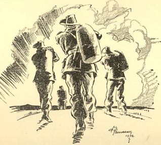
John Watson's story shows insight to the families that moved to Beechworth and the motivation behind this. It showcases the nuances of life in the district and the day to day ways of living. This history speaks of land cultivation and the innovation of industry in the region, in particular cattle farming and butchering. Watson's account speaks of the way that the practice of breeding cattle effects the rural lifestyle, and the hardships that come with working on the land. This oral history recording was part of a project conducted by Jennifer Williams in the year 2000 to capture the everyday life and struggles in Beechworth during the twentieth century. This project involved recording seventy oral histories on cassette tapes of local Beechworth residents which were then published in a book titled: Listen to what they say: voices of twentieth century Beechworth. These cassette tapes were digitised in July 2021 with funds made available by the Friends of the Burke.Watson's account is historically significant due to its ability to illustrate the lifestyle and industry of those in Beechworth during the twentieth century. It is a rare insight into the the practices of residents of this time. This oral history also shows deep insight into the social structure of the community. It describes the family and community dynamics over a long period of time, the motivations behind behaviour, and the greater community fabric. This is a digital copy of a recording that was originally captured on a cassette tape. The cassette tape is black with a horizontal white strip and is currently stored in a clear flat plastic rectangular container. It holds up 40 minutes of recordings on each side.John Watson1800s beechworth, 20th century beechworth, beechworth, farming and agriculture, farm, farm work, farmers, farming, cattle, industry, oral history, john watson -
 Flagstaff Hill Maritime Museum and Village
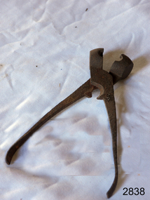
Lead Shot Mould
Bullets for early firearms were made as lead balls in iron scissor moulds. The moulds had scissor action, with ends shaped as a hollow half-sphere that formed a ball when the handles closed. Melted lead was poured into a small filling hole in the top of the closed mould. When the lead was set the handles were opened and the ball was released from the mould. Excess lead was trimmed using the cutting edge of the mould. The task of pouring the melted lead into the mould had to be performed slowly so that air pockets didn’t form. The shot would have a join line around it, which would make it inaccurate; the join needed to be carefully filed to make the ball into a smooth sphere. Larger quantities of lead shot were often cast in a multi-bullet mould that was used in a similar way. Lead shot mould; cast iron, scissor type metal object with sphere shaped mould at end used to make lead shot balls for a shotgun. Mould has a cutting edge to trim off excess lead.flagstaff hill, warrnambool, shipwrecked-coast, flagstaff-hill, flagstaff-hill-maritime-museum, maritime-museum, shipwreck-coast, flagstaff-hill-maritime-village, firearms, bullet, cast bullet, lead ball, lead shot, scissor mould -
 Warrnambool and District Historical Society Inc.
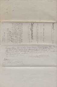
Document, Indenture A Bostock Esquire to Messrs Aitkin & Bostock( Ernest), 1865
The Bostock, Manifold and Aitkin families were all pioneering families in the Western District of Victoria almost from the time of settlement. They leased and owned vast tracts of land and operated businesses around the district, often associated with the farming industry. This document is dated 5th July 1865 and is an assignment of stock by way of mortgage. Augustus Bostock is the mortgagor with James William Manifold Aitkin and Ernest Bostock as mortgagees. At various times they were involved in running businesses together, in particular the Aitkin and Bostock store and flour mill. Three of the Bostock men were married to three of the Aitkin sisters. The amount in question is £2157/3/2 and surety is 8000 sheep and their increase, presently running at Coomete. The penciled in details on the document refer to Robert Brand Paterson who was later in business with Aitkin This is one of a number of documents which relate to the Bostock family who were one of the most important pioneering families of the Western District. They owned and leased various properties around Warrnambool and were involved in many aspects of social and business life. The document itself is indicative of its time and provides an insight into the details and terms of such documents at the time.Large grey coloured, lined hand written document over four pages. Folded in four with date and details on one section. Red wax seal on page 3. There are extra entries written in black lead pencil in areas relating to the money and surety of the agreement.Signed by the following George Barber Warrnambool, Thomas Sunderland Deputy Registrar General, and Augustus Bostock. Hingston & Co, Chancery Lane Melbourne hand written in top left hand corner. warrnambool, bostock,augustus bostock james william manifold aitkin,robert brand paterson, coomete, -
 Eltham District Historical Society Inc
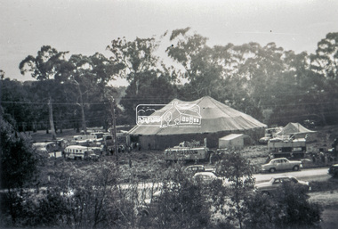
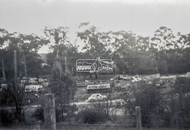
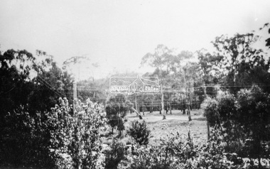
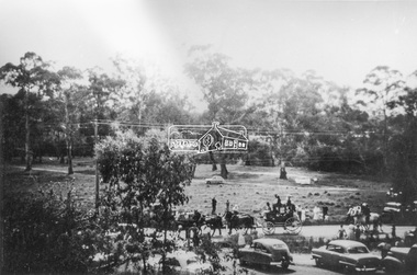
Slide - Photograph, Grace Mitchell, Ashtons Circus set up in Bremner's Reserve, Main Road, Eltham, c.1955
View from Grace Mitchell's shop at the corner of Mount Pleasant Road and Main Road. Grace Mitchell was probably best known for her Eltham shop at the corner of Mt Pleasant Road and Main Road. Grace's memories covered many local identities who were patrons of her shop between 1954 and 1971. From the elevated position of her shop and home Grace was able to view a varied passing parade of Eltham events from ERSILAC, Easter and Eltham Festival parades passing on their way to Eltham Lower Park, circuses in Wingrove Park (then Bremner’s Reserve), roadworks and other happenings. Bremner's Reserve was renamed Wingrove Park c.1970 This photo was from a series of images presented by Grace Mitchell at a Society talk 10 March 1993 on the theme of “My Eltham”.35mm Kodak 5052 TMX Black and White transparency, 1 strip, 6 frames Black and white print 17 x 25.4 cmashtons circus, bremner's flat, circus, grace mitchell, main road, mount pleasant road, wingrove park -
 Eltham District Historical Society Inc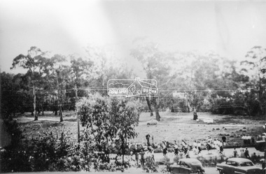
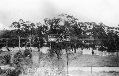
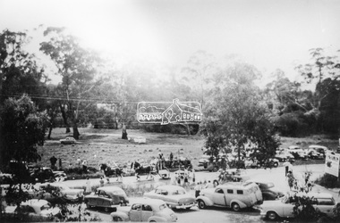
Photograph, Grace Mitchell, Bremners Flat, Main Road, Eltham, 1958c
View from Grace Mitchell's shop at the corner of Mount Pleasant Road and Main Road. Grace Mitchell was probably best known for her Eltham shop at the corner of Mt Pleasant Road and Main Road. Grace's memories covered many local identities who were patrons of her shop between 1954 and 1971. From the elevated position of her shop and home Grace was able to view a varied passing parade of Eltham events from ERSILAC, Easter and Eltham Festival parades passing on their way to Eltham Lower Park, circuses in Wingrove Park (then Bremner’s Reserve), roadworks and other happenings. Bremner's Reserve was renamed Wingrove Park c.1970 This photo was from a series of images presented by Grace Mitchell at a Society talk 10 March 1993 on the theme of “My Eltham”.Black and white print 17 x 25.4 cmbremner's flat, main road, mount pleasant road, wingrove park -
 Eltham District Historical Society Inc
Photograph, Grace Mitchell, Diamond Creek in flood, Bremners Flat, Main Road, Eltham, c.1958
View from Grace Mitchell's shop at the corner of Mount Pleasant Road and Main Road. Grace Mitchell was probably best known for her Eltham shop at the corner of Mt Pleasant Road and Main Road. Grace's memories covered many local identities who were patrons of her shop between 1954 and 1971. From the elevated position of her shop and home Grace was able to view a varied passing parade of Eltham events from ERSILAC, Easter and Eltham Festival parades passing on their way to Eltham Lower Park, circuses in Wingrove Park (then Bremner’s Reserve), roadworks and other happenings. Bremner's Reserve was renamed Wingrove Park c.1970 This photo was from a series of images presented by Grace Mitchell at a Society talk 10 March 1993 on the theme of “My Eltham”.Black and white print 17 x 25.4 cmbremner's flat, diamond creek, floods, main road, mount pleasant road, wingrove park -
 Eltham District Historical Society Inc
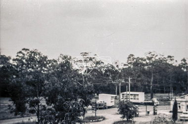
Slide - Photograph, Grace Mitchell, Portable buildings on trucks possibly for installation at the Golden Fleece Service Station, corner of Main Road and Mount Pleasant Road, Eltham, c.1961
View from Grace Mitchell's shop at the corner of Mount Pleasant Road and Main Road. Grace Mitchell was probably best known for her Eltham shop at the corner of Mt Pleasant Road and Main Road. Grace's memories covered many local identities who were patrons of her shop between 1954 and 1971. From the elevated position of her shop and home Grace was able to view a varied passing parade of Eltham events from ERSILAC, Easter and Eltham Festival parades passing on their way to Eltham Lower Park, circuses in Wingrove Park (then Bremner’s Reserve), roadworks and other happenings. Bremner's Reserve was renamed Wingrove Park c.1970 This photo was from a series of images presented by Grace Mitchell at a Society talk 10 March 1993 on the theme of “My Eltham”.35mm Kodak 5052 TMX Black and White transparency, 1 strip, 6 frames Black and white print 17 x 25.4 cmgolden fleece service station, main road, mount pleasant road -
 Eltham District Historical Society Inc
Photograph, Grace Mitchell, Possibly the Ersilac Parade travelling along Main Road, Eltham, c.1958
View from Grace Mitchell's shop at the corner of Mount Pleasant Road and Main Road. Grace Mitchell was probably best known for her Eltham shop at the corner of Mt Pleasant Road and Main Road. Grace's memories covered many local identities who were patrons of her shop between 1954 and 1971. From the elevated position of her shop and home Grace was able to view a varied passing parade of Eltham events from ERSILAC, Easter and Eltham Festival parades passing on their way to Eltham Lower Park, circuses in Wingrove Park (then Bremner’s Reserve), roadworks and other happenings. Bremner's Reserve was renamed Wingrove Park c.1970 This photo was from a series of images presented by Grace Mitchell at a Society talk 10 March 1993 on the theme of “My Eltham”.Black and white print 17 x 25.4 cmcars, bremner's flat, eltham, ersilac parade, main road, mount pleasant road, wingrove park, festival, horse drawn carriage -
 Eltham District Historical Society Inc
Photograph, Grace Mitchell, Possibly the Ersilac Parade travelling along Main Road, Eltham, 1958c
View from Grace Mitchell's shop at the corner of Mount Pleasant Road and Main Road. Grace Mitchell was probably best known for her Eltham shop at the corner of Mt Pleasant Road and Main Road. Grace's memories covered many local identities who were patrons of her shop between 1954 and 1971. From the elevated position of her shop and home Grace was able to view a varied passing parade of Eltham events from ERSILAC, Easter and Eltham Festival parades passing on their way to Eltham Lower Park, circuses in Wingrove Park (then Bremner’s Reserve), roadworks and other happenings. Bremner's Reserve was renamed Wingrove Park c.1970 This photo was from a series of images presented by Grace Mitchell at a Society talk 10 March 1993 on the theme of “My Eltham”.Black and white print 17 x 25.4 cmcars, bremner's flat, eltham, ersilac parade, main road, mount pleasant road, wingrove park, festival, horse drawn carriage -
 Eltham District Historical Society Inc
Photograph, Grace Mitchell, Possibly the Ersilac Parade travelling along Main Road, Eltham, c.1958
View from Grace Mitchell's shop at the corner of Mount Pleasant Road and Main Road. Grace Mitchell was probably best known for her Eltham shop at the corner of Mt Pleasant Road and Main Road. Grace's memories covered many local identities who were patrons of her shop between 1954 and 1971. From the elevated position of her shop and home Grace was able to view a varied passing parade of Eltham events from ERSILAC, Easter and Eltham Festival parades passing on their way to Eltham Lower Park, circuses in Wingrove Park (then Bremner’s Reserve), roadworks and other happenings. Bremner's Reserve was renamed Wingrove Park c.1970 This photo was from a series of images presented by Grace Mitchell at a Society talk 10 March 1993 on the theme of “My Eltham”.Black and white print 17 x 25.4 cmcars, bremner's flat, eltham, ersilac parade, main road, mount pleasant road, wingrove park, festival, horse drawn carriage -
 Lara RSL Sub Branch
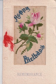
Card, Happy Birthday Card
The silk card were created by French women during the First World War. The women would create these in there homes as a way to earn an income during the tuff times. The silk mesh was embroidered by the women and was later sent to factories to be placed on the cards. According to the Australian war memorial website there were 10 million of the cards made between 1914-1919. This card in particular was sent from John (Jack) McIntyre to his mother for her birthday. J. McIntyre served in the first world war, first arrived in Egypt in 1915, then to the Western front in France in July 1916. He was servery injured during his time in France and was sent to the Hospital in England. After the war finished Jack travelled back to Australia and lived in Lara with his brother and sister.This card is significant as it is a reflection on the communication between families during the First World War. It also is a symbol of the way women in France made their money during the tuff timesA birthday card with silk on the front of the card. It has pink flowers stitched into the silk and says 'happy birthday'On the front it has 'Happy Birthday" "Remembrance" On the first page in the inside "Remembrance" "To mother" "From Jack" "France 1918" On the second page in the inside: "Wishes are nothing; t'is the heart That in the few lines dwells And says to those from us apart More that the greeting tells" birthday card, mother, son, mcintyre, world war 1, ww1, happy birthday, handmade, silk, embroidered -
 Federation University Historical Collection
Book - Booklet, Soldiering On: The Australian Army at Home and Overseas, 1942
Belonged to Clarence (Clarrie) Edward Nicholls who was a communications person on the Sunderland Flying Boats. He was in the Battle of Britain. He was seconded to the RAF and flew out of Plymouth. He was shot down a number of times. He was in the peace keeping corps in Japan and then Korea, and then went into the full time Korea. At one time Clarrie and his two brothers were in New Guinea at the same time. They knew they were all there together but they could not find each other, and officials would not tell them where they were. He flew the last Sunderland back to Lake Boga. He wanted to buzz his parents in Wodonga so he knew he was on the way, but the authorities wouldn't let him. Clarrie Nicholls was a flag bearer for the Melbourne Olympics.Red hard covered book of 200 pages. The following images are by official war artist Geoff Mainwaring (SX13471) who later taught painting at the Ballarat Technical Art School. * 'And Again. So-Heave', page 121 * 'Day's Work Done', page 121 * Untitled image, pg 185 Includes photographs of General Sir Thomas Blamey, Corporal Jim Gordon, John Lavarack, Iven Maccay, Australian Women's Army Service, Convalescent Diggers at Heidelberg Hospital; and maps of the Malay Peninsula and Singapore.clarence nicholls, nicholls, world war 2, geoffrey mainwaring, new guinea, singapore, libya, solomon islands, charles bush, ivor heale, g.j. browning -
 J. Ward Museum Complex
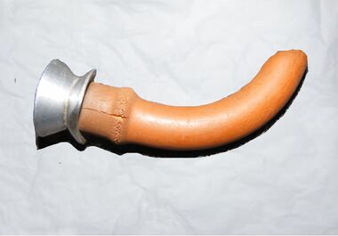
Functional object - Hewitt's Airway, Unknown
Hewitt’s airway was the first known oral airway and laid the foundations for the numerous other airways that were later developed. The development of the oropharyngeal airway is one of the lesser-acknowledged advances in anaesthesia. Oral airways made anaesthesia safer and significantly reduced the trauma associated with earlier attempts at managing the obstructed airway. The Hewitt Airway – the first known artificial oral ‘air-way’. In 1890, Frederic Hewitt noted the frequency and danger of upper airway obstruction. In 1908, dissatisfied with the use of tongue forceps and that Esmarch’s maneuver sometimes failed, he described the first oropharyngeal airway, the Hewitt Airway. The tube was less than 8 cm long, ideally connecting the oral opening to the hypopharynx. The Hewitt Airway was the foundation for many subsequent oropharyngeal airway designs.The oropharyngeal airway is significant because of its lesser acknowledged advances in anaesthesia.Round metal tube with a brown rubber tubing sleeve around the outside.medical health, anaesthesia -
 Phillip Island and District Historical Society Inc.
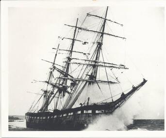
Photograph, The Speke, 22/02/1906
The Speke was an all steel ship of 310 feet, beam of 35 feet and weight of 2,712 tons and triple masted. She was built in 1891 at Carnarvon in Wales for a cost of 22,000 pounds. The wreck of the Speke was purchased for a mere 12 pounds after it went aground in 1906. The Speke had come from Peru to Sydney. She was then on her way to load wheat in Geelong when she ran aground on the 22 February 1906. Captain Tiltson confused a bushfire, near Cowes, for navigation lights. The ship drifted close to shore in Kitty Miller Bay and was eventually holed at 3 pm on the rocks. Life boats were immediately lowered and the ship’s crew all made it to shore except Seaman Frank Henderson, who lost his life.Black & White photograph of The Speke running aground on the south coast of Phillip Island.wreck of the speke, the speke, jack loney -
![Photograph - Digital image, Kelly Garden Supplies [Greensborough], 02/05/2013](/media/collectors/4f729f5697f83e03086015b8/items/5729bced2162f108e8de6b52/item-media/5729bd212162f108e8de74aa/item-fit-380x285.jpg) Greensborough Historical Society
Greensborough Historical SocietyPhotograph - Digital image, Kelly Garden Supplies [Greensborough], 02/05/2013
This photograph of the former site of Kelly Garden Supplies was taken in 2013 to show changes over 40 years, based on Ron Reynold’s sketches in the 1973 publication “Greensborough and Greenhills” published by Cypress Books. The site is now part of the Civic roundabout at the top of the Greensborough By-pass. Civic Drive was associated with the building of Diamond Valley Council Offices opened by Governor Rohan Delacombe on 26/2/1972. Previously it was known as Kelly's Track which wound its way around to a house that overlooked the aqueduct bridge. Kelly's Sandpit (quarry) was the local go to place to obtain road, driveway fill and red sand for local construction. For 80 years previous Kelly's quarry supplied sand to the greater Melbourne area for the surfacing of school grounds, parks etc. Digital copy of colour photograph.greensborough and greenhills, civic drive greensborough, kelly garden supplies, ron reynolds -
![Photograph - Digital image, Willis Vale [2], 1950c](/media/collectors/4f729f5697f83e03086015b8/items/54fd41442162f10d30bf885f/item-media/54fd41912162f10d30bf8caa/item-fit-380x285.jpg) Greensborough Historical Society
Greensborough Historical SocietyPhotograph - Digital image, Willis Vale [2], 1950c
View of Greensborough in the distance from Willis Vale and surrounding land: House built by Edward Maygar, The flowering Hawthorne Bushes were planted by William Partington. Note the prominent house on upper right where Robert Whatmough lived in the mid 19th century and later sold to Partington family. It was located on the Plenty River across from Partington's Flat. The derelict Willis Vale house was destroyed in 1964 when a fire originating from North Plenty Gorge - Kurrak Road - was lit by two teenage boys and made its way several kilometres down to Partington's Flat Greensborough. In 1946, Alan Partington built the Alwyn Farmhouse in place of the original Robert Whatmough home seen in this photo which became Whatmough Park circa 1976.Home of the Partington familyDigital copy of black and white photograph.willis vale, partington family, maygar family, whatmough -
 Greensborough Historical Society
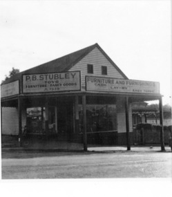
Photograph - Digital image, Stubley's Furniture, 1958c
Stubley's Furniture Store late 1950s. The Stubley Group began in 1946 when Purcell Stubley purchased a site with petrol bowsers in Main Street from 'Snowy' Jessop. In 1948 Purcell began building the new Stubley Motors, working round the old site to keep the business operating. It was completed in 1951. The Group expanded into other areas such as this Furniture store. [Syd Thompson Fruit Shop was here in early 1950s, Syd lived in the house at back. He coached Boxing]. This became the Welkay Store in the 1960's and owned by Walter Kenyon. The Welkay store moved opposite to 100 Main Road on 6/9/1966, ref: Diamond Valley News Page 9. Soon after the store would have been demolished to make way for 'The Valley Building' still on the site in 2018.Digital copy of black and white photographpurcell stubley, stubley motors, stubley group greensborough -
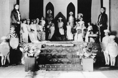 Halls Gap & Grampians Historical Society
Photograph - B/W, C 1934
This is a photo of the "Queen Competition", probably the best remembered entertainment of the 1930's. Four local lasses were chosen to represent the following: Bellfield Hotel, Grampians House, The Cricket Club and the Grampians Mountains. When the long awaited evening came each Queen and her attendants paraded through the hall, the results were announced and the winner (who this year was Valerie Evans) took her place on a throne erected in the middle of the stage. The other Queens made their way to thrones on either side of her. The audience were treated to a right royal display as the "Bishop" placed a crown on the winner's head. Much merriment followed including a play, with students dressed as Minnie and Mickey Mouse and other Disney characters. For the names of the people in the photo refer to "Bridging the Gap" by Ida Stanton, p.88. The photo shows a group of people arranged on and below a dais. There is a woman dressed as royalty sitting on a throne in the centre, flanked by a man dressed as a bishop on the left and a man dressed as a courtier on the right. There are two young girls in long white dresses wearing flowered bands in their hair standing in front of the men. There are more girls in white dresses and flower bands along both sided of the dais and two youths wearing ruffle fronted shirts and holding batons/walking sticks(?) at the front of each row of girls. Carpeted steps lead down from the dais and in front of the dais on either side are two boys dressed as pages. Flower arrangements flank the foot of the stairs.recreation, entertainment -
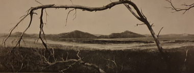
 Kiewa Valley Historical Society
Photograph of Kiewa Valley Panorama, Farming lands within the Kiewa Valley in1950s, Circa 1950
This photograph shows how (early to mid1900s), before the establishment of the Mount Beauty "gated" village, the Kiewa Valley was farmed and the scarce population was spread out over acres of productive land. This photograph catches a time before (what appeared to the local farmers as the invasion by a mass of construction workers) when this remote valley was part of a "lay back" rural landscape,occasionally visited by friends and some wayward tourists. The mountain ranges provided an adequate barrier against the way-would traveller. The immigration numbers coming into Australia was still quite small ( due to the "white" Australia policy) which was in force before World War II. After World War II a mass of displaced European refugees and migrants boosted the Australian population and provided for a greater degree of diverse professions and rural related work force.This photograph depicts the borderline in time between an exclusively rural based population and respective activities(early 1900s)to the present (2000 on wards) integrated village, tourist and retiree/holiday area. The time when land was exclusively used in agriculture is over and the impact of cheaper rural produce from Asian markets will see a shift of land useage and population activities. The Kiewa Valley is loosing its hiding place and is becoming more and more a source of untapped residential land. Black and white photograph of farming/grazing land useage, before the establishment of the Mount Beauty Village. Small pockets of residentual houses can be viewed. Road access (unsealed dirt) was typical of that provided in rural regions in the 1950s. The photo is on 200gms paper and not on photographic paper.kiewa valley in the early1900s, grazing in the kiewa valley, sec victoria -
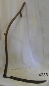 Flagstaff Hill Maritime Museum and Village
Tool - Scythe, 1930-1960
A Scythe was one of the most important of all agricultural hand tools, consisting of a curved blade fitted at an angle to a long, curved handle and used for cutting grain. In modern scythes the handle has a projecting peg that is grasped by one hand, facilitating control of the swinging motion by which grass and grain are cut. The exact origin of the scythe is unknown, but it was little used in the ancient world. It came into wide use only with agricultural developments of the Carolingian era (8th century AD) in Europe, when the harvesting and storing of hay became important to support livestock through winters. Scythes can still be found in use today by hobby farmers and permaculturists. ( producing food, by using ways that do not deplete the earth's natural resources) to cut grass in a more eco-friendly way as opposed to using a machine.A hand tool used for the cutting of crops and grain, modern versions are still being produced today in Europe. The subject item gives us a snapshot into agricultural practices in times past.Scythe with long wood Snath (curved handle) with 1 hand holding piece & curved blade. Noneflagstaff hill, warrnambool, shipwrecked-coast, flagstaff-hill, flagstaff-hill-maritime-museum, maritime-museum, shipwreck-coast, flagstaff-hill-maritime-village -
 Flagstaff Hill Maritime Museum and Village
Lead Shot Mould
Bullets for early firearms were made as lead balls in iron scissor moulds. The moulds had scissor action, with ends shaped as a hollow half-sphere that formed a ball when the handles closed. Melted lead was poured into a small filling hole in the top of the closed mould. When the lead was set the handles were opened and the ball was released from the mould. Excess lead was trimmed using the cutting edge of the mould. The task of pouring the melted lead into the mould had to be performed slowly so that air pockets didn’t form. The shot would have a join line around it, which would make it inaccurate; the join needed to be carefully filed to make the ball into a smooth sphere. Larger quantities of lead shot were often cast in a multi-bullet mould that was used in a similar way. Lead shot mould; cast iron, scissor type metal object with sphere shaped mould at end used to make lead shot balls for a shotgun. Mould has a cutting edge to trim off excess lead.flagstaff hill, warrnambool, shipwrecked-coast, flagstaff-hill, flagstaff-hill-maritime-museum, maritime-museum, shipwreck-coast, flagstaff-hill-maritime-village, firearms, bullet, cast bullet, lead ball, lead shot, scissor mould -
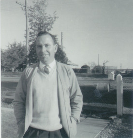
 Heyfield & Districts Historical Society
Bill spike, George Edward Barraclough (1906-1981), 1940s-1950s
George Barraclough (1907-1981), a landholder from north of Licola, in the Victorian Great Divide, made a number of these spikes, as needed. As accounts were paid, receipts were pasted to the account, the account was impaled on the spike, and the spike was rehung on a nail on a wall stud. All transactions dealing with money were filed in this manner, as an orderly way of tracking items that were usually remotely ordered and delivered on the mail car. George Barraclough used No8 in a number of creative ways, and his durable and untilitarion toasting forks are still in family use today. After George died in 1981 the spikes with their accounts passed to his daughter Linda Barraclough, who archived the accounts and later made copies available for study. Those accounts form a record of the businesses of Heyfield for 1940s and 1950s.This bill hook is of historical significance as a survivor of bush ingenuity and bush filing systems. Commercially made bill spikes were in common use in offices, where they usually consisted of a heavy metal base with an upright pointed piece of wire. Number 8 fencing wire was an important and readily accessible repair commodity for rural dwellers, and achieved iconic status as the most generic method of repair for cars broken down (resort to nearest fence) and was even used to hold houses together. Referring to "No 8 fencing wire" became a type of Australian shorthand for bush ingenuity. It is no longer available, being replaced by 4mm high tensile wire. This item is important both as an example of inventive use of No8 wire, and also as an example of the bush filing methods in use in the 1940s and 1950s. No 8 fencing wire holds a similar position in New Zealand - see Wikipedia NZ at http://en.wikipedia.org/wiki/Number_8_wire A section of number 8 fencing wire twisted to form a bill spike. It has a rounded.base made from several twists of wire in a flat platform, with the remaining wire rising from the centre to form a stem that terminates in a hook with a sharpened point.wire, bush ingenuity, barraclough, licola north -
 Robin Boyd Foundation
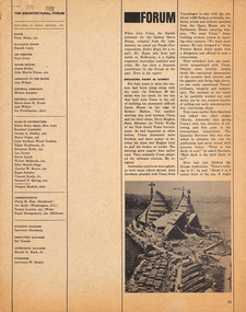
Article, Robin Boyd, Breaking point in Sydney, Apr-66
Robin Boyd was asked to write this article, after Jorn Utzon resigned for the Sydney Opera House commission. Description of the tension between Utzon requiring more freedom to develop his ideas, and the pressure applied by Davis Hughes, State Minister of Public Works of NSW Government. Boyd describes the controversy, the outblowing of costs. Robin Boyd’s desk cupboard contained two exercise books (item D482.1-D482.2) and assorted articles, essays and other material regarding the building of the Sydney Opera House, inserted inside the front cover of Walkabout magazine, July 1966 (item P1377). This publication is one of those inserts. Many of these were collected by Boyd’s eldest daughter, Mandie, who recalls that her father was writing a book, but was very disillusioned with the way the entire Opera House saga unfolded. A reprint from The Architectural Forum pp 21-22.Also p23-24, pp 81-84.A reprint from The Architectural Forum, p21.sydney opera house, utzon, davis hughes, arne jacobsen, saarinen, arup, edward herbert farmer, sydney opera house project, walsh st library -
 Robin Boyd Foundation
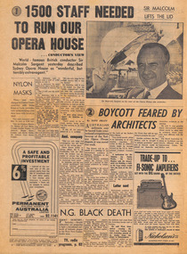
Newspaper - Clipping, Sun-Herald, 1500 Staff needed to run our opera house.... conductor's view' and 'Boycott Feared by Architects’, 15.5.1966
The first article describes the opinion of the British conductor Sir Malcolm Sargent to his visit to the Sydney Opera House. The second article, by Tony Pratt, discusses a possible boycott of Australian architects in competitions to be decided at the annual meeting of the International Union of Architects' International Contents Committee. Robin Boyd’s desk cupboard contained two exercise books (item D482.1-D482.2) and assorted articles, essays and other material regarding the building of the Sydney Opera House, inserted inside the front cover of Walkabout magazine, July 1966 (item P1377). This publication is one of those inserts. Many of these were collected by Boyd’s eldest daughter, Mandie, who recalls that her father was writing a book, but was very disillusioned with the way the entire Opera House saga unfolded.sydney opera house, utzon, sydney opera house project, walsh st library -
 Robin Boyd Foundation
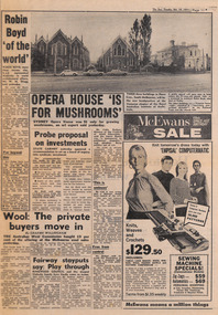
Newspaper - Clipping, The Sun, Opera house 'is for mushrooms' & Robin Boyd 'of the world', 19.10.1971
The Opera House article reports on the disparaging opinion of Mr Colin Badger, director of the Council of Adult Education, pn the Sydney Opera House.The other article reports on the speech given by Mr WW Shugg, Federal President of RAIA as a memorial tribute to Robin Boyd at the RAIA building. Robin Boyd’s desk cupboard contained two exercise books (item D482.1-D482.2) and assorted articles, essays and other material regarding the building of the Sydney Opera House, inserted inside the front cover of Walkabout magazine, July 1966 (item P1377). This publication is one of those inserts. Many of these were collected by Boyd’s eldest daughter, Mandie, who recalls that her father was writing a book, but was very disillusioned with the way the entire Opera House saga unfolded.Articles on p11.sydney opera house, utzon, sydney opera house project, walsh st library -
 Ballarat Heritage Services
Photograph - Colour, Tower Hill, 2016, 31/12/2016
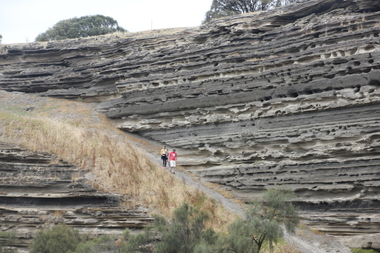
Tower Hill is a volcanic formation believed to have erupted about 32,000 years ago. Its formation is known as a "nested maar" and it is the largest example of its type in Victoria. During formation, molten lava pushed its way up through the Earth’s crust and encountered a layer of water-bearing rock. Violent explosions followed creating a shallow crater which later filled with water to form the lake. Further eruptions occurred in the centre of this crater, creating the islands and cone shaped hills. In 1892 Tower Hill became Victoria’s first National Park. In 1961, Tower Hill became a State Game Reserve under the then Fisheries and Wildlife Department and a major re-vegetation program began. (https://www.towerhill.org.au/index.php/about-reserve/history, accessed 23 December 2019)A number of photographs taken at Tower Hill, including the lakes, volcanic ash layer, and koala.tower hill, ash layer, volcano -
 Ballarat Heritage Services
Photograph - Image, Tower Hill, Victoria, c1918, c1918
Tower Hill is a volcanic formation believed to have erupted about 32,000 years ago. Its formation is known as a "nested maar" and it is the largest example of its type in Victoria. During formation, molten lava pushed its way up through the Earth’s crust and encountered a layer of water-bearing rock. Violent explosions followed creating a shallow crater which later filled with water to form the lake. Further eruptions occurred in the centre of this crater, creating the islands and cone shaped hills. In 1892 Tower Hill became Victoria’s first National Park. In 1961, Tower Hill became a State Game Reserve under the then Fisheries and Wildlife Department and a major re-vegetation program began. (https://www.towerhill.org.au/index.php/about-reserve/history, accessed 23 December 2019)Black and white image of Tower Hill, near Koroit, Victoria.tower hill, volcano, crater -
 Ballarat Heritage Services
Photograph - Colour photograph, Tower Hill, 2016, 23/12/2015
Tower Hill is a volcanic formation believed to have erupted about 32,000 years ago. Its formation is known as a "nested maar" and it is the largest example of its type in Victoria. During formation, molten lava pushed its way up through the Earth’s crust and encountered a layer of water-bearing rock. Violent explosions followed creating a shallow crater which later filled with water to form the lake. Further eruptions occurred in the centre of this crater, creating the islands and cone shaped hills. In 1892 Tower Hill became Victoria’s first National Park. In 1961, Tower Hill became a State Game Reserve under the then Fisheries and Wildlife Department and a major re-vegetation program began. (https://www.towerhill.org.au/index.php/about-reserve/history, accessed 23 December 2019)Panaramic view of Tower Hill, Victoria.tower hill, volcano, crater