Showing 12375 items matching "railways"
-
 Wodonga & District Historical Society Inc
Programme - Albury-Wodonga Rail Centenary Celebrations, VicRail Public Relations Division, 1983
This item was written for the celebration of the centenary of the linking by rail of Victoria and New South Wales systems on June 14, 1883. It gives a brief history of the stages and stories surrounding the linking of the lines and the events which occurred in 1883. It also contains a programme of activities held in Albury and Wodonga as part of the celebrations a century later.An 8 page leaflet printed on buff coloured paper with brown print. It includes 3 photos and an itinerary for the celebrations.fiction This item was written for the celebration of the centenary of the linking by rail of Victoria and New South Wales systems on June 14, 1883. It gives a brief history of the stages and stories surrounding the linking of the lines and the events which occurred in 1883. It also contains a programme of activities held in Albury and Wodonga as part of the celebrations a century later.vline safety, vline training, railways victoria -
 Wodonga & District Historical Society Inc
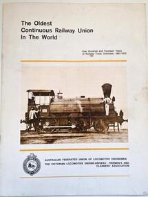
Booklet - The Oldest Continuous Railway Union in the World, AFULE Federal Office, 1975
This booklet was produced by the Australian Federated Union of Locomotive Enginemen in 1975. On that date the Victorian Division of the Australian Federated Union of Locomotive Enginemen was 114 years old, making it the oldest continuous railway union in the world. It was formed as the Locomotive Engine Drivers' Association in 1861- just 7 years after the first railway, Flinders Street, Melbourne to Sandridge (now Port Melbourne) was officially opened. This booklet also marked the occasion of the first major renovations to the Union's premises and facilities since the building was completed in December 1914.This booklet is a small paperback of 27 pages including some images explaining the background of the Victorian Division of the Australian Federated Union of Locomotive Enginemen.fictionThis booklet was produced by the Australian Federated Union of Locomotive Enginemen in 1975. On that date the Victorian Division of the Australian Federated Union of Locomotive Enginemen was 114 years old, making it the oldest continuous railway union in the world. It was formed as the Locomotive Engine Drivers' Association in 1861- just 7 years after the first railway, Flinders Street, Melbourne to Sandridge (now Port Melbourne) was officially opened. This booklet also marked the occasion of the first major renovations to the Union's premises and facilities since the building was completed in December 1914.australian federated union of locomotive enginemen, afule, railway unions -
 Wodonga & District Historical Society Inc
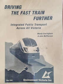
Booklet - Driving the Fast Train Further, Wendy Everingham and John McPherson, May 2001
This document is a response by Environment Victoria to the Fast Train Report. It advocates the establishment of an integrated transport approach in Victoria including the need for a Rural and Regional Planning Strategy to be developed in conjunction with the Metropolitan StrategyA publication of 34 pages produced by Environment Victoria Inc. It has brown cover featuring an image of a locomotive superimposed over an outline map of Victoria. It consists of 36 pages including appendices, references, a map of an Environment Victoria Enhanced Victorian Passenger Rail Network and a map of the Victoria's Regional and Rural Bus service.fiction This document is a response by Environment Victoria to the Fast Train Report. It advocates the establishment of an integrated transport approach in Victoria including the need for a Rural and Regional Planning Strategy to be developed in conjunction with the Metropolitan Strategyrailways environmental impact, victorian railways, environment victoria -
 Wodonga & District Historical Society Inc
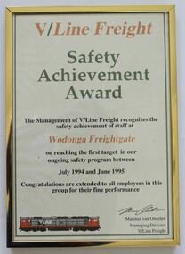
Certificate - V/Line Freight Safety Achievement Award, VLine Freight, 1995
This certificate was awarded to the Wodonga Freightgate for achieving targeted safety standards as set down in the VLine program between July 1994 and June 1995This certificate recognises the safety standards achieved by workers at the Wodonga freight centre in Northeast Victoria.A framed certificate in recognition of the achievement of safety standards at Wodonga Freightgate.vline safety, wodonga railway, wodonga freightgate -
 Wodonga & District Historical Society Inc
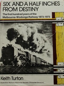
Book - Six and a Half Inches from Destiny: First 100 Years of Melbourne to Wodonga Railway, 1873 - 1973, Keith W. Turton
Inter-colonial railway communication was established in 1883 when the Melbourne - Wodonga railway was extended over the River Murray to meet the New South Wales railhead at Albury. When the two lines finally met a significant fact became apparent - the track gauges of the two systems differed by six and a half inches. For 80 years this difference created havoc until a new railway of uniform gauge was built parallel to the Victorian gauge line from Melbourne to Wodonga. This book deals with the planning, construction and the first 100 years of operation or the railway to Wodonga, together with its locomotives, stations and trains which travelled its tracks.non-fictionInter-colonial railway communication was established in 1883 when the Melbourne - Wodonga railway was extended over the River Murray to meet the New South Wales railhead at Albury. When the two lines finally met a significant fact became apparent - the track gauges of the two systems differed by six and a half inches. For 80 years this difference created havoc until a new railway of uniform gauge was built parallel to the Victorian gauge line from Melbourne to Wodonga. This book deals with the planning, construction and the first 100 years of operation or the railway to Wodonga, together with its locomotives, stations and trains which travelled its tracks.railways victoria, railway melbourne to wodonga -
 Wodonga & District Historical Society Inc
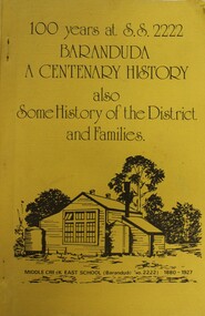
Booklet - 100 YEARS AT S.S. 2222 BARANDUDA: a centenary history, Rosemary Boyes, 1980
This booklet tells the story of Baranduda State School 2222 and was produced to celebrate its centenary. It also includes information about the history of the district and some of its pioneer families. Baranduda pastoral run was taken up in 1845 and it is thought that the name was derived from an Aboriginal expression relating to a swamp or a water rat. A few kilometres south-west there is the beginning of the Baranduda Range, of which the summit is Mount Baranduda. Baranduda was a rural hamlet with numerous German farm selectors, who came from South Australia. Beginning with the grazing of cattle and later dairying and sawmilling were added, serving markets in Wodonga and providing timber sleepers for railway construction. The primary school was opened in 1880.non-fictionThis booklet tells the story of Baranduda State School 2222 and was produced to celebrate its centenary. It also includes information about the history of the district and some of its pioneer families. Baranduda pastoral run was taken up in 1845 and it is thought that the name was derived from an Aboriginal expression relating to a swamp or a water rat. A few kilometres south-west there is the beginning of the Baranduda Range, of which the summit is Mount Baranduda. Baranduda was a rural hamlet with numerous German farm selectors, who came from South Australia. Beginning with the grazing of cattle and later dairying and sawmilling were added, serving markets in Wodonga and providing timber sleepers for railway construction. The primary school was opened in 1880.baranduda state school, education victoria, community history baranduda -
 Wodonga & District Historical Society Inc
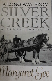
Book - A Long Way from Silver Creek: A Family Memoir, Margaret Gee, 2000
This book tells the story of Margaret Gee's family, spanning three generations living on the land in picturesque North Eastern Victoria, near Beechworth-Kelly country and steeped in the history of the gold rush and early pioneers. It is the story of her indomitable father, who grew up at Silver Creek, then joined the Australian Navy, became a prisoner of war on the Burma Railway after surviving the sinking of HMAS Perth, of his wife and family.non-fictionThis book tells the story of Margaret Gee's family, spanning three generations living on the land in picturesque North Eastern Victoria, near Beechworth-Kelly country and steeped in the history of the gold rush and early pioneers. It is the story of her indomitable father, who grew up at Silver Creek, then joined the Australian Navy, became a prisoner of war on the Burma Railway after surviving the sinking of HMAS Perth, of his wife and family.gee family, beechworth, rural families, country life -- victoria -
 Wodonga & District Historical Society Inc
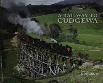
Book - A Railway to Cudgewa, Nick Anchen, 2013
The spectacular mountain railway from Wodonga to Cudgewa in north eastern Victoria was one of Australia's truly fascinating branch lines, and the most challenging to operate on the Victorian Railways. It was a railway of scenic splendour, famous for its towering wooden bridges, notoriously steep grades, Hereford cattle and K class steam locomotives. This lavishly illustrated publication includes over 100 colour and B&W photographs, and tells the story of the railway through the memories of Cudgewa railway enginemen, station masters, bridge gangers,non-fictionThe spectacular mountain railway from Wodonga to Cudgewa in north eastern Victoria was one of Australia's truly fascinating branch lines, and the most challenging to operate on the Victorian Railways. It was a railway of scenic splendour, famous for its towering wooden bridges, notoriously steep grades, Hereford cattle and K class steam locomotives. This lavishly illustrated publication includes over 100 colour and B&W photographs, and tells the story of the railway through the memories of Cudgewa railway enginemen, station masters, bridge gangers,railroads victoria, railways cudgewa, railways wodonga, railways high country -
 Wodonga & District Historical Society Inc
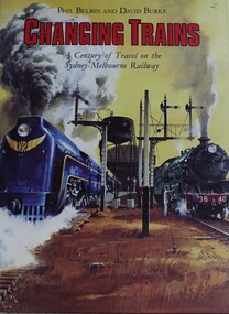
Book - Changing Trains : A Century of Travel on the Sydney-Melbourne Railway, Phil Belbin and David Burke, 1982
This book is the story of the hundred years of the Sydney-Melbourne railway connection. It is about the trains - the Express, the Limited, the Spirit of Progress, the Southern Aurora - and the locomotives that pulled them.non-fictionThis book is the story of the hundred years of the Sydney-Melbourne railway connection. It is about the trains - the Express, the Limited, the Spirit of Progress, the Southern Aurora - and the locomotives that pulled them.sydney-melbourne railway, train travel australia, railways australia -
 Wodonga & District Historical Society Inc
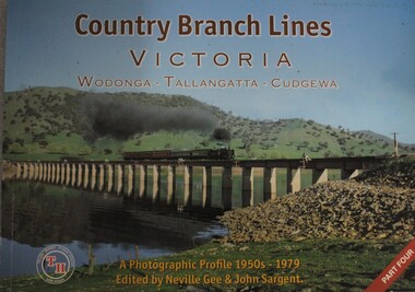
Book - Country Branch Lines Victoria: Wodonga - Tallangatta - Cudgewa: a Photographic Profile 1950s - 1979, Neville Gee and John A. Sargent, 01 Feb 2008
The book covers the branch line that ran eastward from Wodonga past Lake Hume and on to Tallangatta, over the highest point on Victorian Railways at Shelley and terminated at Cudgewa. A photographic profilenon-fictionThe book covers the branch line that ran eastward from Wodonga past Lake Hume and on to Tallangatta, over the highest point on Victorian Railways at Shelley and terminated at Cudgewa. A photographic profilelocomotives -- victoria -- history, cudgewa train, victoria railways, high country trains -
 Wodonga & District Historical Society Inc
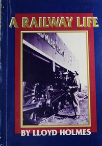
Book - A Railway Life, Lloyd Holmes, 1991
Lloyd Homes records 40 years of experience as an employee on the New South Wales and then Victorian Railways. His rich powers of description, keenness of observation and sense of humour result in a book that is very readable for anyone with a love of Australia. He captures the remote life of the railway, the warmth of human companionship and traces the transition from steam to diesel haulage.non-fictionLloyd Homes records 40 years of experience as an employee on the New South Wales and then Victorian Railways. His rich powers of description, keenness of observation and sense of humour result in a book that is very readable for anyone with a love of Australia. He captures the remote life of the railway, the warmth of human companionship and traces the transition from steam to diesel haulage.new south wales railways, victorian railways, railroads history -
 Wodonga & District Historical Society Inc
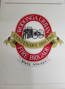
Book - Wodonga Urban Fire Brigade Centenary 1893- 1993, Country Fire Authority Victoria, C. 1993
The Wodonga Fire Brigade was founded in 1893 from a need to protect life and property in what was a small town straddling the Melbourne-Sydney railway line. This book traces the first 100 years of its development and service to the community.The Wodonga Fire Brigade was founded in 1893 from a need to protect life and property in what was a small town straddling the Melbourne-Sydney railway line. This book traces the first 100 years of its development and service to the community.history wodonga urban fire brigade, cfa wodonga -
 Wodonga & District Historical Society Inc
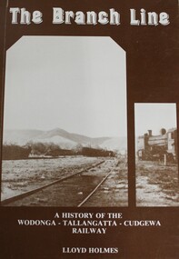
Book - The Branch Line : A history of the Wodonga - Tallangatta - Cudgewa Railway, Lloyd Holmes, 1985
This railway story concerns just one of the many branch lines that snaked across the landscape of Victoria. This book concentrates on the Wodonga - Tallangatta - Cudgewa line, a railway that took 32 years to complete from starting point to eventual terminus. The first section of the Wodonga to Tallangatta line opened in 1889 and was further extended in 1891. It was a vital community link until the passenger service closed in September 1961. The last regular goods train on the line ran on 21st April 1978. The north- east train line to Wodonga remained a significant factor in the development of Wodonga as a rural city in the 20th century.non-fictionThis railway story concerns just one of the many branch lines that snaked across the landscape of Victoria. This book concentrates on the Wodonga - Tallangatta - Cudgewa line, a railway that took 32 years to complete from starting point to eventual terminus. The first section of the Wodonga to Tallangatta line opened in 1889 and was further extended in 1891. It was a vital community link until the passenger service closed in September 1961. The last regular goods train on the line ran on 21st April 1978. The north- east train line to Wodonga remained a significant factor in the development of Wodonga as a rural city in the 20th century.railroads -- victoria, northeastern victoria, tallangatta, wodonga railways, cudgewa railroad -
 Wodonga & District Historical Society Inc
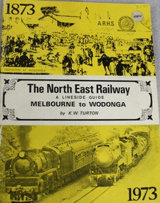
Book - The NORTH EAST RAILWAY Melbourne to Wodonga- A Lineside Guide, Keith W. Turton, 1973
A detailed history and description of the North East Rail Line, including information about each station and siding and relevant maps.non-fictionA detailed history and description of the North East Rail Line, including information about each station and siding and relevant maps.railway transport victoria, north east railway victoria, victoria railways, lineside rail guide -
 Wodonga & District Historical Society Inc
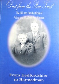
Book - Dust From the Pine Trees : The Life and Family Stories of Arthur and Elizabeth Ann Henman - From Bedfordshire to Barmedman, Lila McCann & Betty Lawrence
The story of the life, family and achievements of Arthur Henman, born in 1861 in Lidlington, Bedfordshire, England and his wife Elizabeth Ann nee Pollard of Bonegilla, Victoria. For a time on arrival in Australia at the age of 17, Arthur had a contract to supply timber to the New South Wales Railway Department. After marrying in 1888, Arthur and Elizabeth became successful dairy farmers in Glen Innes, northern New South Wales, before deciding to come to the Barmedman district. They took up the property, now well known as "Pine Valley." They had a pioneer's task to face for a thick belt of green timber stretched from the back door of their first home to Temora. Undaunted by the task, but with great determination and courage, they fashioned a first class property out of the wild and waste of those days and made valuable contribution to the fledgling communities until retirement from active farming in 1923 when they moved to Sydney.non-fictionThe story of the life, family and achievements of Arthur Henman, born in 1861 in Lidlington, Bedfordshire, England and his wife Elizabeth Ann nee Pollard of Bonegilla, Victoria. For a time on arrival in Australia at the age of 17, Arthur had a contract to supply timber to the New South Wales Railway Department. After marrying in 1888, Arthur and Elizabeth became successful dairy farmers in Glen Innes, northern New South Wales, before deciding to come to the Barmedman district. They took up the property, now well known as "Pine Valley." They had a pioneer's task to face for a thick belt of green timber stretched from the back door of their first home to Temora. Undaunted by the task, but with great determination and courage, they fashioned a first class property out of the wild and waste of those days and made valuable contribution to the fledgling communities until retirement from active farming in 1923 when they moved to Sydney.pioneers australia, pioneers nsw, arthur henman, elizabeth ann pollard, barmedman district nsw -
 Wodonga & District Historical Society Inc
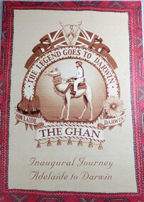
Booklet - The Legend Goes to Darwin - The Ghan Inaugural Journey Adelaide to Darwin, Great Southern Railway Travel Pty Ltd, 2004
Brochure published to commemorate the inaugural journey of the Ghan from Adelaide to Darwin. The Ghan takes its name from the 19th century Afghan camel drivers who arrived in Australia and helped to explore the country's remote interior. The original line linked Adelaide to Alice Springs was completed in 1929. After 126 years of planning, and at a cost of $1.3 billion, the first passenger train reached Darwin on 3 February 2004.non-fictionBrochure published to commemorate the inaugural journey of the Ghan from Adelaide to Darwin. The Ghan takes its name from the 19th century Afghan camel drivers who arrived in Australia and helped to explore the country's remote interior. The original line linked Adelaide to Alice Springs was completed in 1929. After 126 years of planning, and at a cost of $1.3 billion, the first passenger train reached Darwin on 3 February 2004.the ghan, railways australia, inland railways australia, railway adelaide to darwin -
 City of Kingston
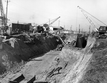
Photograph - Black and white, c. 1958
Moorabbin station sits on the Frankston line which first opened in 1882 when the line was extended from Mordialloc. Moorabbin station opened in 1881 and was originally called South Brighton station. It was renamed Moorabbin station in 1907. In 1958 the station was relocated below street level which coincided with other construction works on Nepean Highway and South Road. This image is part of a larger collection of images from the Public Transport Corporation displaying train stations and streetscapes in what is now the City of Kingston.Black and white photograph showing excavations for Moorabbin station to be moved below street level. Stamped in blue ink on reverse: COPYRIGHT / Public Transport Corporation / For re-ordering photographs / Please quote negative No M6004 / Enquiries C/- PTC Photographic Unit / Telephone switchboard 619 111moorabbin, railway station, construction works, suburbs, nepean highway -
 City of Kingston
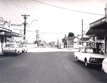
Photograph - Black and white, c. 1960
This image is part of a larger collection of images from the Public Transport Corporation displaying train stations and streetscapes in what is now the City of Kingston.Black and white photograph depicting the level crossing at Highett, with the shopping street visible in the foreground. There are several cars parked on both sides of the road and a bus has just crossed the crossing (on the left hand side).Stamped in blue ink on reverse: COPYRIGHT / Public Transport Corporation / For re-ordering photographs / Please quote negative No H3983 / Enquiries C/- PTC Photographic Unit / Telephone switchboard 619 111highett, railway station, suburbs, streetscape -
 City of Kingston
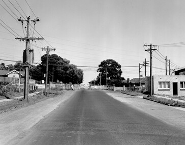
Photograph - Black and white, Public Transport Corporation, c. 1960
Black and white photograph depicting closed crossing gates at the level crossing at Park Road, Cheltenham. This image is part of a larger collection of images from the Public Transport Corporation displaying train stations and streetscapes in what is now the City of Kingston.Black and white photograph of Cheltenham level crossing at Park Road, Cheltenham. The gates are closed. Stamped in blue ink on reverse: COPYRIGHT / Public Transport Corporation / For re-ordering photographs / Please quote negative No H3052 / Enquiries C/- PTC Photographic Unit / Telephone switchboard 619 111 White paper stuck to reverse of image, with black typed text: Cheltenham Park Road, Cheltenham / 1965 / $50 reproduction fee appliescheltenham, railway crossing, suburbs, public transport -
 City of Kingston
Photograph - Black and white, c. 1970
The Highett Gas Works were a landmark along the Nepean Highway for many years. With the cessation of the gasification of coal and the introduction of natural gas to Victoria, the gas holders were demolished and the Sir William Fry Reserve was developed on the southern end of the site. The Gas and Fuel redeveloped the northern end of the site with modern offices and laboratories for the organisation's scientific services. At this time, the chimney and retort house were retained.The Highett Gasworks had its beginning in 1939 operated by the Central Brighton and Moorabbin Gas Co Ltd. The company had expanded its gas production facilities to Highett where it had purchased 45 acres of land adjacent to the Melbourne-Frankston railway line. The first gasholder was erected on the Highett site in 1927 and connected with high pressure mains to the Brighton Gas Works. In 1939 the building program including gasometers, the vertical retort house and coal store was completed and gas making commenced. Its area of supply covered approximately 70 square miles and included the municipalities of Brighton, Sandringham, Moorabbin, Mordialloc, Chelsea and part of Dandenong. The Gas and Fuel Corporation eventually took over operations and with the disaggregation and privatisation of the organisation, the site was eventually closed c. 2002.Black and white aerial photograph featuring the Highett Gas Works with gasholders and retort house. In the top right-hand corner, a former Highett Primary School on Graham Road can be viewed. Photograph includes Bay Road, Royal Avenue, Princess Avenue and Jackson Road (Highett) and Alfred, Turner and Sandford Streets (Moorabbin).Handwritten in black ink: [indecipherable] in a circle Handwritten in red ink: 70% Four velcro display adhesivesgasification of coal, gas and fuel corporation of victoria, gasholders, highett, moorabbin, utilities -
 City of Kingston
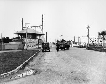
Photograph - Black and white, c. 1930
This image is part of a larger collection of images from the Public Transport Corporation displaying train stations and streetscapes in what is now the City of Kingston.The Nepean Highway is a major highway running through the City of Kingston. This image is one of many that depicts its importance to the local community as it undergoes many changes over time.Black and white photograph depicting the level crossing at Moorabbin. While the gates at the level crossing are open, two cars are making their way across the crossing, while a third car is parked on the side of the road, in front of a large billboard/hoarding for ham and bacon products. There is a man standing on the road as if watching the cars go through the crossing. The road appears to be unsealed. Black printed text on a round white sticker adhered to the reverse: 148 Handwritten in red ink: 60% Blue ink stamped on reverse: COPYRIGHT / Public Transport Corporation / For re-ordering photographs / Please quote negative No ADU907 / Enquiries C/- PTC Photographic Unit / Telephone switchboard 619 111moorabbin, trains, railway crossing, level crossing, cars, roads, nepean highway -
 City of Kingston
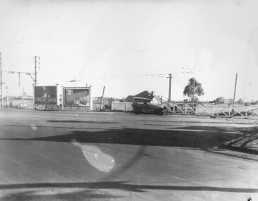
Photograph - Black and white, c. 1930
This image is part of a larger collection of images from the Public Transport Corporation displaying train stations and streetscapes in what is now the City of Kingston.The Nepean Highway is a major highway running through the City of Kingston. This image is one of many that depicts its importance to the local community as it undergoes many changes over time.Black and white photograph of the level crossing at Neapean Highway Moorabbin. Photograph is a slightly side view, with a blurred image of a car approaching the level crossing. The gates are closed. To the left of the image is a pair of billboards. The billboard on the left is promoting Creamoata, a New Zealand brand of oats, and the billboard on the right is promoting Kraft cheese.White round sticker on reverse with black printed text: 147 Handwritten in red ink on reverse: 100% Blue ink stamped on reverse: COPYRIGHT / Public Transport Corporation / For re-ordering photographs / Please quote negative No ADV 1030 / Enquiries C/- PTC Photographic Unit / Telephone switchboard 619 111moorabbin, level crossing, railway crossing, cars, advertising, nepean highway -
 City of Kingston
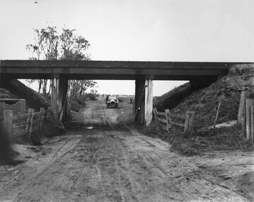
Photograph - Black and white, c. 1920
This image is part of a larger collection of images from the Public Transport Corporation displaying train stations and streetscapes in what is now the City of Kingston.While the focus of this image is the train line running overhead, the unsealed nature of the road speaks to the progression of suburban development during the 1920s.Black and white image of an unsealed underpass at Patterson Road, looking west. A car has stopped on the road in the distance and man is standing on the duckboard leaning into the car.Round white sticker on reverse with black printed text: 177 Handwritten in red ink: 60% Blue ink stamped on reverse: COPYRIGHT / Public Transport Corporation / For re-ordering photographs / Please quote negative No ADV 300 / Enquiries C/- PTC Photographic Unit / Telephone switchboard 619 111patterson road, railway, trains, cars, unsealed roads -
 City of Kingston
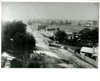
Photograph - Black and white, Percy Fairlam, c. 1910
Black and white image of Cheltenham in the early 20th Century depicts an almost idyllic life. This photo was taken by Percy Fairlam, who climbed a tall pine tree to achieve the aerial view. The tree was a well recognised feature of the Cheltenham skyline but was cut down some time before World War II.Cheltenham was established as a rural market gardening community. The development of the railway was crucial to the ongoing development of the area. Community life sprung up around the railway line which is evident in the proximity of shopping and leisure.Black and white image depicting aerial view down Charman Road, Cheltenham, including the unsealed road, level crossing and shopping centre. What appears to be a cricket pitch is located behind the shops.Handwritten in black ink on a red round sticker adhered to the reverse, and then crossed out: X14 Handwritten in blue ink on reverse: A8 Handwritten in red ink on reverse: 85%cheltenham, railway crossing, roads, housing, shopping strip -
 City of Kingston
Photograph - Black and white, c. 1950
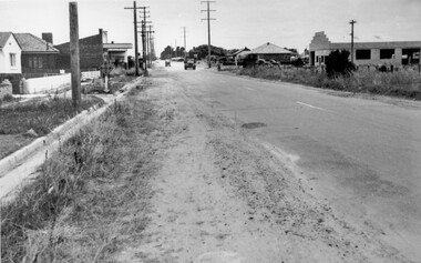
While the road is sealed, there is evidence of potholes that have been filled, and the wide, gravel shoulder has long grass running into the gutter of the nature strip. On the other side of the road, extremely long grass can be seen growing on the side of the road. There is a truck visible on the road, which indicates the rural nature of the Cheltenham community in the 1950s.This image is one of many in the collections that focuses on the railway or roads. The development of roads and the railway was crucial to the ongoing development of the area. Black and white photograph of the intersection of Warrigal and Centre Dandenong roads, Cheltenham. On the left hand side is a small sign warning of a cross roads intersection. Housing and shops line the road.Handwritten in blue ink on reverse: 219 Handwritten in red ink on reverse: 80%cheltenham, roads, suburbs -
 City of Kingston
Photograph - Black and white, 1950
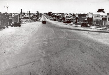
This photograph depicts the increasing urbanisation of a once rural area at Moorabbin.This image is one of many in the collections that focuses on either roads or the railway. The development of roads and the railway was crucial to the ongoing development of the area. Black and white photograph of South Road, Moorabbin, with Station Street to the right and Jasper Road further down to the left. Along both sides of the road are retail spaces which become homes on the left hand side, after Jasper Road.Handwritten in red ink on reverse: 80% Handwritten in blue ink on reverse: 216moorabbin, roads, cars, shopping strip, housing -
 City of Kingston
Photograph - Black and white, c. 1950
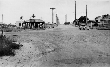
The intersection of Warrigal Road and Nepean Highway is now a major intersection, serviced by traffic lights. In the 1950s it was a joining of two sealed roads, although covered in gravel, and with wide gravel shoulders. There are no traffic signs and the few houses visible are not set very far back from the road. This image is one of many in the collections that focuses on either roads or the railway. The development of roads and the railway was crucial to the ongoing development of the area.Black and white photograph of the intersection of Warrigal Road and Nepean Highway, Mentone. Handwritten in blue ink on reverse: 218 Handwritten in red ink on reverse: 75%mentone, roads, suburbs -
 City of Kingston
Photograph - Colour, 29 January 1993
Bonbeach is a small beachside suburb located between Chelsea and Carrum. The station was opened in 1926 and was the last to be established in the group from Aspendale to Carrum. Urban growth began after World War II. State primary and high schools were opened in 1958 on land in Breeze Street that was once occupied by The Australian Glass Manufacturers. Immediately east of the school sites is the Patterson River Golf Club. The Bonbeach sports reserve has five ovals and is home to the Bonbeach football and baseball clubs. The suburb borders the Edithvale-Seaford Wetlands which is the remnant site of the Carrum Carrum swamp, once the home of the Bunurong people.Bonbeach was originally a seaside destination for holidaymakers and the housing comprised of holiday homes and gradually more permanent residents. It was not until 1926 that Bonbeach had its own railway station. From 1906 until the late 1940s sand was quarried on the east side of the railway line and used in the manufacture of glass. The Australian Glass Manufacturers sold this land in residential blocks and Bonbeach's permanent population spread from the coastal strip across to the other side of the railway line. Laminated colour aerial photograph of the suburb of Bonbeach and also the southern section of neighbouring Chelsea within the City of Kingston. The extent of this 1993 aerial image includes: Top left - Maury Road at the south end of the Chelsea shopping Centre; Top right - Scotch Parade Chelsea Bottom left - Monica Avenue in Bonbeach; Bottom right - Patterson River Golf Club. Landmarks include St Joseph's Church and Primary School, Chelsea Primary School, Bonbeach Station, Bonbeach Fotball Club sports playing fields and Bonbeach Life Saving Club. The Edithvale Wetlands is featured prominently to the right-hand side of the image. Black typed writing on white adhesive label: No. 6662 Black typed writing on white adhesive label: 26E/6662, 29/1/93, 4.25 pm Black typed writing on white adhesive label: 29-1-93 Black typed writing on white adhesive label: P000109 Circular yellow adhesive sticker bonbeach, chelsea -
 City of Kingston
Photograph - Black and white, c. 1925
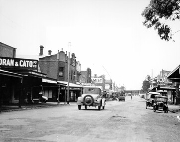
This image explores the relationship between the train lines and community development. Cheltenham's retail centre is connected to the train station.Black and white image of Charman Road, Cheltenham, depicting a car and truck travelling toward the level crossing near the train station. There is another car already waiting at the crossing gates. Cars are parked on either side of the road along a shopping strip.Black printed text on a white round sticker adhered to the reverse: 141 Handwritten in red ink on reverse: 50% Black typed text on a white strip of paper adhered to reverse: Charman Road, Cheltenham / circa late 1920's/early 1930's / $50 reproduction fee applies Blue ink stamped on reverse: COPYRIGHT / Public Transport Corporation / For re-ordering photographs / Please quote negative ADV 485 / Enquiries C/- PTC Photographic Unit / Telephone switchboard 619 1111cheltenham, trains, railway, railway crossing, shopping strip, cars -
 City of Kingston
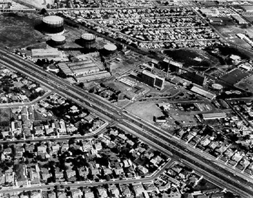
Photograph - Black and white, 20 December 1945
This aerial photograph depicts the changing landscape of Cheltenham and Highett since WWII. Photographed in 1945, there is a mix of urban dwellings and industrial development and precedes the major transformation of Cheltenham with the development of the Southland shopping centre in the 1960s and expansion in the 1990s.A large part of Cheltenham was originally established as a rural market gardening community. The railway line and station brought urban development to the area and in the north, the Highett area was dominated by the Highett Gas Works. Cheltenham became a major destination for shopping in the 1960s with the opening of Southland.Aerial photograph taken in 1945 of Cheltenham and Highett within the City of Kingston. The image includes the Highett Reserve, (top right), the Methodist Children Homes (now Southland), Nepean Highway and Jamieson Street. Highett Gas Works is visible in the top left and the land now named William Fry Reserve at the intersection of Bay Road and Nepean Highway. A visible large parcel of land on the corner of Bay Road and Nepean Highway was developed in the 1990s as the west side addition to Southland. The densely vegetated area in the upper right sector of the image is now dense with housing. Tulip Grove, Heather Grove and Gilford Street are visible bottom left. This image is possibly from the collection of aerial photographs commissioned by the Department of Crown Lands and Survey and taken by Adastra Airways.Black ink: 57252 White lettering: VIC-10 57252 20.12.45 [lens information indecipherable] PROJ. No.5 MELB. METROP AREA Black pencil: 80highett, cheltenham, highett gas works, urbanisation