Showing 23168 items
matching creeks
-
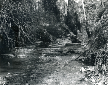
 Clunes Museum
Photograph
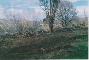
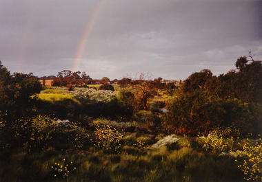
COLOUR PHOTOGRAPH CLEARING ALONG CLUNES CREEK, BLACKMORE ROAD BELOW THE FORDlocal history, photography, photographs, clunes landscape -
 Stawell Historical Society Inc
Photograph, Bicycle Display at Stawell Historical Society c2019, 2019
David Francis & Greg Robson in front of Bicycle display set up by David a Member of Stawell Historical SocietyGreg Robson & david Francis in doorway of Pleasant Creek historic Precinct Gallerysports -
 Stawell Historical Society Inc
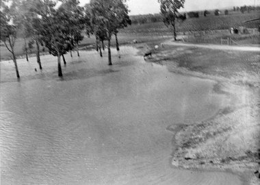
Photograph, Flood on Concongella Creek, Great Western, early 1900's
Digital Photo taken from glass slide by Geoff McMillan, Cooper Street Stawell and reproduced as a photo - printed at Stawell Historical Society 2019Black & White Photo of flood on the Concongella Creek at Best's vineyard, Great Western. -
 Whitehorse Historical Society Inc.
Article, Joy at Mullum Mullum wildlife finds, 2005
Article on echidna sighting near Mullum Mullum Creek. With photo of Betty Millner.Article on echidna sighting near Mullum Mullum Creek. With photo of Betty Millner.Article on echidna sighting near Mullum Mullum Creek. With photo of Betty Millner.millner, betty, mullum mullum creek, echidnas -
Whitehorse Historical Society Inc.
Map, City of Whitehorse, 1/03/1995 12:00:00 AM
Map of City of Whitehorse prepared by Richard Meloni showing roads, railways, creeks.Map of City of Whitehorse prepared by Richard Meloni showing roads, railways, creeks.Map of City of Whitehorse prepared by Richard Meloni showing roads, railways, creeks.blackburn, nunawading, blackburn south, mitcham, vermont, vermont south, blackburn north, forest hill, burwood east, city of whitehorse -
 Whitehorse Historical Society Inc.
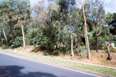
Photograph, Deep Creek Road, 2001
Coloured Photo of Deep Creek Road, Mitcham, prior to clearing for erection of Bridge.deep creek road, mitcham. -
 Whitehorse Historical Society Inc.
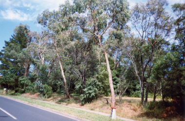
Photograph, Deep Creek Road, 2001
Coloured Photo of Deep Creek Road, Mitcham, prior to clearance for Bridge building.deep creek road, mitcham -
 Whitehorse Historical Society Inc.
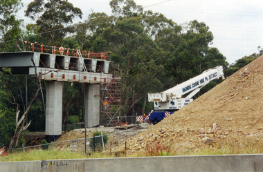
Photograph, Bridge Work - Deep Creek Road, 1/02/2002 12:00:00 AM
Coloured Photo of Work progressing on Bridge spanning Deep Creek Road, Mitcham.deep creek road, mitcham. -
 Whitehorse Historical Society Inc.
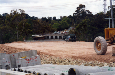
Photograph, Bridgeworks - Mitcham
Coloured photograph of bridgeworks taking place along Deep Creek Road, Mitchamdeep creek road, mitcham -
 Whitehorse Historical Society Inc.
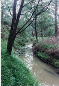
Photograph, Yarran Dheran
Coloured photo of Bushland along Walk in Yarran Dheran. Mullum Mullum Creek.yarran dheran, mullum mullum creek -
 Whitehorse Historical Society Inc.
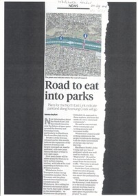
Article, Road to Eat Into Parks, 2018
Plans for the North East Link indicate parkland along Koonung Creek will go.Plans for the North East Link indicate parkland along Koonung Creek will go.Plans for the North East Link indicate parkland along Koonung Creek will go.north east link, koonung creek, blackburn north, eastern freeway, whitehorse active transport action group, city of whitehorse, bicycle paths -
Ballarat Heritage Services
Photograph, Clare Gervasoni, Brookside Farm Looking Towards the Creek, 21/01/2021
A video of Brookside Homestead looking towards the Creek, taken from the public roadway.brookside, farm, homestead -
 Ballarat Heritage Services
Painting - Artwork, Lisa Gervasoni, Yandoit Creek Summer Oblique ,2021, 2021
Interpretation of the Gervasoni farms at Yandoit Creek using a fauvist colour palette.Lisa J. GERVASONI Born Melbourne, Victoria Graduating from Royal Melbourne Institute of Technology where she received a Bachelor of Applied Science-Planning, and the University of Melbourne with a Master of Environmental Studies Lisa Gervasoni's artwork reflects her passion for the landscape and built form. Lisa Gervasoni specialises in photography, embroidery and acrylic paintings on canvas. Many of her works have the theme of interpretation of heritage and cultural spaces. Dedicated to recording cultural heritage in situ Lisa Gervasoni has used photography to document urban areas, heritage sites and natural resources of Australia.She has provided over 70,000 images to the National Library of Australia Trove database via the Flickr portal. In 2004 Lisa Gervasoni won the Daylesford Small Art Prize for an embroidered depiction of the Savoia Hotel in Hepburn Springs, and in 2022 she was shortlisted in the Harden Landscape prize. Her art mediums are photography, embroidery and acrylic on canvas. Many of her works have a theme of interpretation of heritage and cultural spaces. abstract, modernPainted stretched canvas depicting an abstract aerial oblique of Yandoit Creek, Victoria.gervasoni farm yandoit creek, lisa gervasoni, yandoit creek, italo-australians -
 Whitehorse Historical Society Inc.
Photograph, Mullum Mullum Creek
Black and white photograph of the Mullum Mullum Creek flowing past Yarran Dheranyarran dheran, mullum mullum creek -
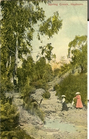 Ballarat Heritage Services
Postcard, Spring Creek, Hepburn
A coloured postcard showing women at Spring Creek, the former name for Hepburn Springs. hepburn springs, spring creek, mineral water -
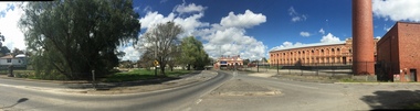 Ballarat Heritage Services
Photograph, Clare Gervasoni, Hill Street Bridge, Yarrowee Creek, and Sunnyside Mill, Ballarat East, 2016, 17/09/2016
Four panoramas showing Hill Street Bridge, Yarrowee Creek, and Sunnyside Mill.yarrowee creek, hill street bridge, sunnyside mill, ballarat woollen mill -
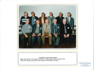 Old Castlemaine Schoolboys Association Inc.
Photograph, Past Pupils of Campbells Creek Primary School 2001, 13/10/2001
photograph Containing past pupils of Campbells creek Primary School at reunion in 2001 -
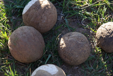 Ballarat Heritage Services
Photograph - Colour, Clare Gervasoni, Wooden bocce balls at Yandoit Creek, 2016, 2016
The Gervasoni family made bocce balls from the roots of trees, because the timber was harder. These bocce balls are probably over 100 years old.Colour photographs of wooden bocce ball used by the Gervasoni family at Yandoit Creek.maurie gervasoni, bocce, yandoit creek -
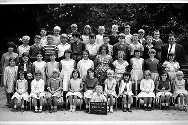 Southern Sherbrooke Historical Society Inc.
Photograph, Menzies Creek State School photo, 1966
A photograph of students, teacher and Head Teacher from Menzies Creek State School. -
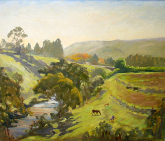 Brimbank City Council Art Collection
Painting, Maribyrnong River from Horseshoe Bend Road, Keilor, 1977
Local SceneImpressionistic view of valley with a creek running through it. Three horses in the foreground - AR0064Information about the artist on the back. "James Farrell is a member of the Victorian Artists Society" and "is represented at the Australian War Memorial, Canberra".keilor, maribyrnong, river, painting, impressionist, landscape -
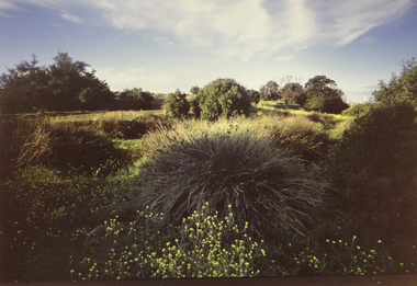 Brimbank City Council Art Collection
Photograph, Robert Pointon, West Bank of the Kororoit Creek looking north, 1988
Local SceneHuntsman Chemical works, West Bank of the Kororoit Creek looking north - AR0019 -
 Brimbank City Council Art Collection
Photograph, Robert Pointon, Kororoit Creek looking North east, 1993
Local SceneKororoit Creek looking North east with the Albion explosive site in the background - AR0020 -
 Stawell Historical Society Inc
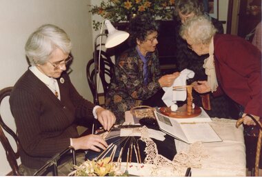
Photograph, Tapestry Lace and Flowers fund raising demonstration by Mrs Laby & friend of Maryborough Joy Attrill Stawell Historical Society
Tapestry Lace and Flowers fund raising demonstration by Mrs Laby & friend of Maryborough Joy Attrill Stawell Historical SocietyThree colour photographs inside Pleasant Creek Courthouse of Fund raising event stawell -
 Stawell Historical Society Inc
Painting, c1985
Painting in colour of Pleasant Creek Court House by Judith Meyer (nee Henderson)stawell, artwork -
 Stawell Historical Society Inc
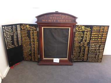
Memorabilia - Realia, 1863-1910
Merit Board MUIOOF Loyal Pleasant Creek Lodge No 5080. Grand Masters stawell -
 Whitehorse Historical Society Inc.
Photograph - Black and white photograph, Yarran Dheran Mitcham
Black and white photo of Mullum Mullum Creek at Yarran Dheran in Freeway reserve.mullum mullum creek, yarran dheran -
 Lakes Entrance Historical Society
book, Heard, Barry, View from Connor's Hill, 2007
Barry Heard tells of life in Swifts Creek area in mid 1900'ssettlement, social history -
 Falls Creek Historical Society
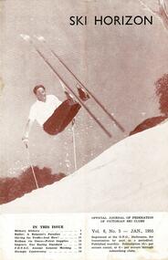
Journal - Ski-Horizon Vol 6 No 5
Ski-Horizon is the official journal of the Federation of Victorian Ski Clubs which began publication in 1949. The were 26 original member clubs which included Albury Ski Club, Bogong Ski Club, Myrtleford Ski Club, Tallangatta and District Ski Club and Wangaratta Ski Club. Two pioneers of Falls Creek, Tom Mitchell, M.L.A., and Martin Romuld were Vice-Presidents of the Federation.This Journal is significant because it documents the early development of skiing in Victoria.The journal features stories and events chronicling developments in Victoria and internationally. There were no items specifically related to the Falls Creek Area in this issue. The front cover featured Rudi Wurth, winner of the National Slalom and Downhill titles at Kosciusko, 1954. An advertisement for Fred Griffith's property "Toonallook" was again included inside the back cover.rudi wurth, falls creek, fred griffith -
 Falls Creek Historical Society
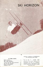
Journal - Ski-Horizon Vol 6 No 7
Ski-Horizon is the official journal of the Federation of Victorian Ski Clubs which began publication in 1949. The were 26 original member clubs which included Albury Ski Club, Bogong Ski Club, Myrtleford Ski Club, Tallangatta and District Ski Club and Wangaratta Ski Club. Two pioneers of Falls Creek, Tom Mitchell, M.L.A., and Martin Romuld were Vice-Presidents of the Federation.This Journal is significant because it documents the early development of skiing in Victoria.The journal features stories and events chronicling developments in Victoria and internationally. There were no items specifically related to the Falls Creek Area in this issue. The front cover featured Rudi Wurth, winner of the National Slalom and Downhill titles at Kosciusko, 1954. An advertisement for Fred Griffith's property "Toonallook" was again included inside the back cover.tom mitchell m.l.a., bogong ski club, rudi wurth -
Glenelg Shire Council Cultural Collection
Negative - Negative -Mrs Arabella Maschmedt standing on a wooden walkway beside Salt Creek, Portland Victoria, Zilah Maschmedt, c. 1934
Part of a collection of photographs taken by Zillah Maschmedt in 1934. Zillah was a teacher from South Australia.Negative for black and white photo. Mrs Arabella Maschmedt standing on a wooden walkway beside Salt Creek. Wooden retaining wall along both sides of creek, near opening to sea. Bluestone house on opposite bank.