Showing 6762 items matching " rivers"
-
![Scene Near the Buffalo Mountains / [by] Nicholas Caire, circa 1876](/media/collectors/550653872162f11fb04854aa/items/57826074d0cdd1176ce5bcc1/item-media/578260d1d0cdd1176ce5f61a/item-fit-380x285.jpg) Kew Historical Society Inc
Kew Historical Society IncPhotograph, Anglo-Australasian Photographic Company, Scene Near the Buffalo Mountains, c. 1876
Nicholas Caire was born on Guernsey in the Channel Islands in 1837. He arrived in Adelaide with his parents in about 1860. In 1867, following photographic journeys in Gippsland, he opened a studio in Adelaide. From 1870 to 1876 he lived and worked in Talbot in Central Victoria. In 1876 he purchased T. F. Chuck's studios in the Royal Arcade Melbourne. In 1885, following the introduction of dry plate photography, he began a series of landscape series, which were commercially successful. As a photographer, he travelled extensively through Victoria, photographing places few of his contemporaries had previously seen. He died in 1918. Reference: Jack Cato, 'Caire, Nicholas John (1837–1918)', Australian Dictionary of Biography.An original, rare photograph from the series 'Views of Victoria: General Series' by the photographer, Nicholas Caire (1837-1918). The series of 60 photographs that comprise the series was issued c. 1876 and reinforced a neo-Romantic view of the Australian landscape to which a growing nationalist movement would respond. Nicholas Caire was active as a photographer in Australia from 1858 until his death in 1918. His vision of the Australian bush and pioneer life had a counterpart in the works of Henry Lawson and other nationalist poets, authors and painters.‘Scene near the Buffalo Mountains’ : Views of Victoria (General Series) No.41 : Albumen silver photograph | Photo on card with Title and Description on reverse | Mounted 24 x 30 cm; Photo 12 x 17 cm.On Reverse: ‘This scene is taken from the banks of the Buckland River, which is about five miles distant from the Buffalo Mountains, as seen in the distance. These mountains are frequently covered with snow, in consequence of their great altitude. The Buckland River is a small tributary of the Ovens River, which flows through the Beechworth district, and eventually finds its way to the River Murray. The Bridge which is seen on the right of the picture forms the roadway which leads from the Buckland Camp to the Township of Bright.’nicholas caire (1837-1918), landscape photography -
![Wal Ives & Bert [Watson] at the outlet of the Kew Main Drain](/media/collectors/550653872162f11fb04854aa/items/61593ef27608a87f688412b1/item-media/61594a5a7608a87f68848c29/item-fit-380x285.jpg) Kew Historical Society Inc
Kew Historical Society IncPhotograph - Wal Ives & Bert [Watson] at the outlet of the Kew Main Drain, c.1900
Connor's Creek is/was one of two major waterways bisecting Kew, both of which empty into the Yarra River. Connor's Creek originates near the grounds of Genazzano FCJ College, which is one of the highest points in Kew. Until the 1930s, this was an open creek until a barrel drain - the Kew Main Drain - was constructed. As the creek ran through Kew it cut across a number of roads the maintenance of which was a continuing concern for Kew Councillors. In August 1864, the Council called for tenders to erect a stone culvert and embankment over Connor's Creek, on Belford-road. This may be the embankment on which the boys are sitting.Original, small photographic positive on card of two boys, identified by the donor as 'Wal Ives and Bert' [Albert Watson] sitting on bluestone capping above an outlet of Connor's Creek. To the left of the boys is a barrel drain which at that stage was the outlet for Connor's Creek near the Yarra River. The retaining wall is constructed of brick. In ink on photo: "Wal & Bert"connors creek -- kew (vic), wal ives, albert watson, belford road, yarra river -- kew (vic.), creeks -- kew (vic.), drains -- kew (vic.) -
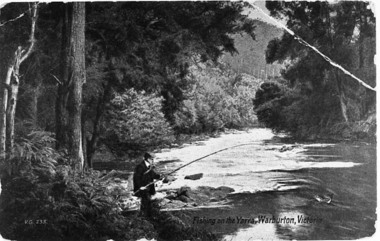 Upper Yarra Museum
Negative Photographic Reproduction, PC Fishing on the Yarra River, Warburton
Post Card Fishing on the Yarra River, Warburton Negative Black white Scanned at 600 dpipc fishing yarra river warburton -
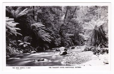 Marysville & District Historical Society
Postcard (item) - Black and white postcard, Rose Stereograph Company, The Taggerty River, Marysville, Victoria, 1913-1967
A postcard in a series produced by the Rose Stereograph Company in Victoria, Australia as a souvenir of Marysville.A black and white photograph of the Taggerty River in Marysville in Victoria.POST CARD The "Rose" Series/ De Luxe A Real Photograph/ Produced in Australia Published by the Rose Stereograph Co.,/ Armadale, Victoria.taggerty river, marysville, victoria, p. 2337, rose series postcard, postcard, souvenir -
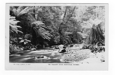 Marysville & District Historical Society
Postcard (item) - Black and white postcard, Rose Stereograph Company, The Taggerty River, Marysville, Victoria, 1913-1967
A postcard in a series produced by the Rose Stereograph Company in Victoria, Australia as a souvenir of Marysville.A black and white photograph of the Taggerty River in Marysville in Victoria.POST CARD REAL PHOTO THE "ROSE" SERIES DE LUXE PRODUCED IN AUSTRALIA Published by "The Rose Stereographs"/ Armadale, Victoria.taggerty river, marysville, victoria, p. 2337, rose series postcard, postcard, souvenir -
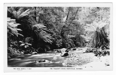 Marysville & District Historical Society
Postcard (item) - Black and white postcard, Rose Stereograph Company, The Taggerty River, Marysville, Victoria, 1913-1967
A postcard in a series produced by the Rose Stereograph Company in Victoria, Australia as a souvenir of Marysville.A black and white photograph of the Taggerty River in Marysville in Victoria.POST CARD THE "ROSE" SERIES DE LUXE A Real Photograph Produced in Australia Published by The Rose Stereograph Co./ Armadale, Victoria.taggerty river, marysville, victoria, p. 2337, rose series postcard, postcard, souvenir -
 Bendigo Military Museum
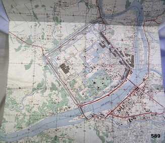
Map - MAP HUE VIETNAM, C.1960’s
The city of Hue is in South Vietnam. The map was used by a member of the AATTV during the Tet Offensive in Thau Thien province. Map brought home from Vietnam by Murray Stanley Metherall. Refer 590.2.Colour printed map of Hue Citadel on paper. Aerial view of land, river and building outlines.hue, vietnam, tet -
 Lorne Historical Society
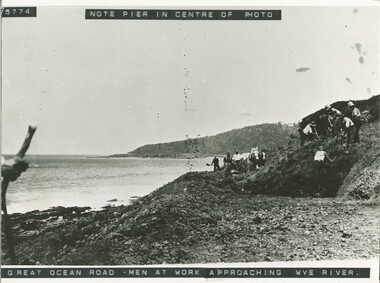
Photograph, Work on Great Ocean Road approaching Wye River
Photograph showing men at work on the G.O.R near Wye River. View of Pier centre photographg.o.r.; workmen; pier-at-wye-river; -
 Glenelg Shire Council Cultural Collection
Negative - Negative - Glenelg River at Nelson, Victoria, Miss Zillah Maschmedt, photographer, c. 1936
Negative for a black and white photograph. Image shows Glenelg River at Nelson, Victoria, looking downstream. -
Glenelg Shire Council Cultural Collection
Negative - Negative - Glenelg River, Nelson, Victoria, c. 1936
Transparency for black and white photo. Nelson, Vic. view of Glenelg River, fence leading into water -
Glenelg Shire Council Cultural Collection
Negative - Negative - Nelson, Victoria, c. 1936
Transparency for black and white photo. Panoramic view of Nelson, Vic, looking towards river mouth -
Glenelg Shire Council Cultural Collection
Postcard - Postcard - Suspension bridge Casterton, 1900-1930
SOURCED FROM CASTERTON TOWN HALL (FORMER SHIRE OF GLENELG) Sourced from Casterton Town Hall (Former Shire of Glenelg)Postcard, black and white,, showing the suspension bridge at Casterton, view across river towards townshipFront: 'SUSPN BRIDGE CASTERTON' Back: Handwritten correspondence, addressed to 'Miss M. Sythaleigh, Henty St Casterton' -
 Federation University Historical Collection
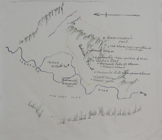
Plan, Dunn's Map of Early Gold Diggers at Golden Point, Ballarat, not dated
Hand drawn map in colour showing Yarrowee River and claims including James Oddie and Highett.dunn, dunn's map, comissioner's tent, oddie's claim, highett's claim, macdonald, suter & co claim, james oddie, golden point, gold discovery -
 Bendigo Historical Society Inc.
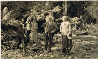
Photograph - BLACK AND WHITE PHOTOGRAPH: TAGGERTY RIVER MARYSVILLE 1924-5
black and white photograph - Family and friends at Taggerty River Marysville 1924-5. Marysville Victoria.photograph, person, male / female, taggerty river marysville 1924-5 -
Port Melbourne Historical & Preservation Society
Photograph - Westgate Park, David Thompson, c. 1994
Eleven colour photographs of Westgate Park and birdlife, bank of Yarra River skirting the park, and the Puntbuilt environment - civic -
 Port Melbourne Historical & Preservation Society
Photograph - Wangaratta, Yarra River, Roy Liebig, 1945
The donor's (Karen Bowden) grandfather - Roy Liebig (1897-1968) - took these photos in the 1940s. Karen, as administrtor of his estate, has extracted various photos and sent them to appropriate historical societies.A series of photographs taken by Roy Liebig in the 1940s Hard copy and digital. "Nairana" Yarra Rivermaritime, piers and wharves, war - world war ii, roy liebig, karen bowden, yarra river, nairana -
Port Melbourne Historical & Preservation Society
Map - City of South Melbourne, 1854 - 1884
Detailed map of City of South Melbourne. Date uncertain. Shows early configuration of river and docks."South Melbourne, Sheet 2"emerald hill, town planning -
Port Melbourne Historical & Preservation Society
Map - Chart, Hobson's Bay, river and navigational aids, 1839 - 1843
On back is handwritten note - Hobson's Bay pp from HMS Beagle 1838-43.Map (Chart) of Hobson's Bay, River and Navigational Aids 1839. (Latrobe Library). in photographic form.melbourne harbor trust - port of melbourne authority, hobson's bay -
 Bendigo Historical Society Inc.
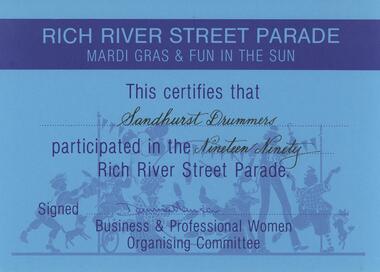
Document - SANDHURST DRUMMERS COLLECTION: CERTIFICATE, 1990
Documents. Blue Participation Certificate for Sandhurst Drummers from Rich River Street Parade 1990.document, memo, participation certificate -
 Bendigo Historical Society Inc.
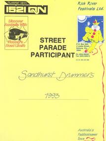
Document - SANDHURST DRUMMERS COLLECTION: CERTIFICATE, 1993
Document. Certificate awarded to Sandhurst Drummers Street Parade Participant 1993 Rich River Festival.document, memo, certificate. -
 Bendigo Historical Society Inc.
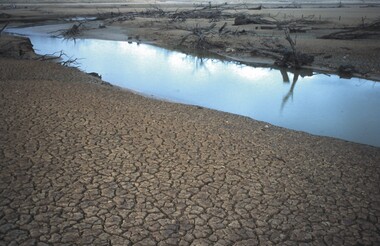
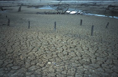
Slide - VAL DENSWORTH COLLECTION: DRY LAKE EPPALOCK, May 2004
Slide. Dry Lake Eppalock. The Campaspe River flowing so slowly through Lake Eppalock.slide, bendigo, dry lake eppalock., dry lake eppalock. -
 Bendigo Historical Society Inc.
Slide - VAL DENSWORTH COLLECTION: DRY LAKE EPPALOCK, May 2004
Slide. Dry Lake Eppalock. The Campaspe River snakes through the dry bed of Lake Eppalock.slide, bendigo, dry lake eppalock., dry lake eppalock. -
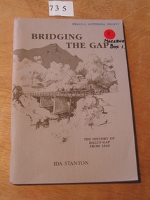 Stawell Historical Society Inc
Book, Ida Stanton, Bridging The Gap 1988 -- The History of Halls Gap From 1840 by Ida Stanton, 1988
Tales of Hall's Gap in the Grampians, as collected by the Pupils of Hall's Gap Primary School, from the descendants of Pioneer Families, and Recorded prior to 1940. Rerecorded from old well worn notes, by Grant W Greenwood, Head Teacher 1937-1939.Fawn cover with drawing of trees and mountain in the background. in the foreground is a bridge over a river, with a woman in a dray. Presented to Stawell Historical Society Ida Stanton May 1989stawell grampians -
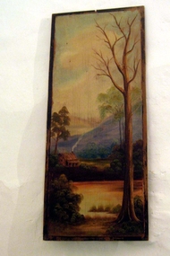 Whitehorse Historical Society Inc.
Painting - Panel Painting
In the early 1920s Reginald and Gladys Skelton rented Schwerkolt Cottage. When they left to live in their new home on Deep Creek Road, having been encouraged by Mrs. Louis Schwerkolt to purchase the block, they where given this painting which was on a panel on the door of the eastern room. When the Nunawading Council was refurbishing the Cottage in 1964, Mr Skelton returned the panel. This information was provided by Lyn Davies the daughter - in - law of Mr. and Mrs. Skelton.Painting depicting a rural scene with a river and a bared tree in the foreground and a house, fields and hills in the background.illustrations, oil -
 Rutherglen Historical Society
Photograph - Image, The Argus
Girl Guide troop shown is probably one led by Florence Iggsten.Black and white photograph of a group of Girl Guides on an excursion next to a river. Some of them are in a boat.On back of photo: a rubber stamp saying "Please acknowledge 'The Argus', Melbourne Australia. Copyright Photograph. Negative No. E149 Reference No. ____"girl guides, camping -
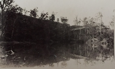 Kew Historical Society Inc
Photograph - Zig-zag Bridge on the Yarra River at Kew, Henry Beater Christian, 1920-28
Henry Christian (c.1809-91), the grandfather of the photographer, was one of the first settlers in Kew. He arrived in Victoria with his wife Agnes and son Orlando in 1855 on the Gypsy Queen. He established a rope-making business in Bulleen Road by 1858 but was declared insolvent two years later. In his final years, he was celebrated as one of the oldest living settlers of the district. His son, Orlando Henry Beater Christian (c.1853-1930) became a member of the Hawthorn Band and a foundation member of the Willsmere Swimming Club. Orlando and his wife Elizabeth had four children of which Henry Beater Christian (1886-1962) was the eldest.Small black and white photograph of the Zig-zag Bridge over the Yarra River at Studley Park.henry christian (1886-1962), landscape photography, yarra river -- studley park -- kew (vic.), zig-zag bridge -- yarra river -- kew (vic.), christian-washfold collection -
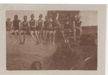 Sunbury Family History and Heritage Society Inc.
Photograph, c1920s
The swimmers were seated on the diving board over Jacksons Creek at The Nook, which served as a swimming pool in Sunbury until 1966 when the long-awaited for swimming pool was officially opened in Ligar Street on19th January 1966. For a number of years before the official opening townspeople organised many fund raising events to pay for the new pool. The pool at The Nook served as a popular swimming place for many years in Sunbury during the summer weather.A sepia photograph with a white border of a group of eight swimmers sitting on a diving board over a river. swimming, the nook, swimming clubs -
Montsalvat
Photograph, Untitled (Indigenous Man), 1960
Black and white photograph of an indigenous man seated on the river bank with his image reflected in the water. Signed in pencil (Ll) '1/10' (Lc) 'Matcham Skipper' and dated (Lr) 'circa 1960' on matt boardmatcham skipper, photograph, indigenous, male -
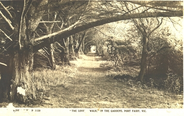 Port Fairy Historical Society Museum and Archives
Postcard - Post Card, The Rose Series / The Rose Stereographs, The Lovers Walk in the Gardens, Port Fairy
The Port Fairy Botanical Gardens were formed in 1856 making it one of the earliest gardens in Victoria. The first curator was James Prior, he was paid fifty-two pounds per annum. He was an outstanding curator having been apprenticed to the trade in England at the age of 12, his brother Edward in later years was the Curator of the Koroit Gardens. Prior retired in 1903. During the years of his curatorship Port Fairy was said to have the best gardens outside the city of Melbourne, he was constantly in touch with Baron Von Mueller and later Guilfoyle of the Royal Botanical Gardens of Melbourne. In the early years plants from all over the world were planted here with varying rates of success many of them sent by Baron Von Mueller. In the 1930’ and 40’s the gardens were still very beautiful, and the curator was Roy Manuell. The beautiful iron gates at the entrance were destroyed in the 1946 floods and were replaced in 1989 using some of the material from the original gates. From the 1950’s on the gardens went into a state of decline, much being taken up by the caravan park until in 1986, after a public meeting ‘Friends of the Gardens’ was founded when the entrance section was restored. Black and white Photograph of the path running along the river side of the gardens with trees overhanging the walkThe Rose Series P 1139 The Lovers Walk in the Gardens, Port Fairy, Vic.lovers walk - gardens, path, botanical, trees -
Tarnagulla History Archive
Postcard - Photographic postcard: Loddon River, Newbridge near Tarnagulla, c. 1900-1920s
Williams Family Collection. Monochrome photographic postcard, Reids Series No.5. Front image depicting the Loddon River at Newbridge. tarnagulla