Showing 2559 items
matching aerial
-
 Glenelg Shire Council Cultural Collection
Photograph - Photograph - Portland Harbour, n.d
Port of Portland Authority ArchivesBack: harb016 - pencilport of portland archives, k s anderson wharf, silos, lee breakwater, ocean pier -
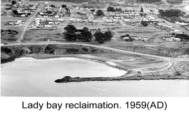 Glenelg Shire Council Cultural Collection
Photograph - Photograph - Lady Bay reclamation, c. 1960
Port of Portland Authority archivesFront: (no inscriptions) Back: Lady Bay Reclamation 1959 (black pen, upper left)port of portland archives, lady bay, reclamation -
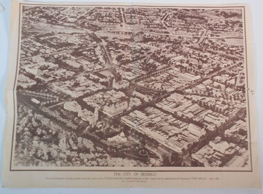 Bendigo Historical Society Inc.
Document - BAGGALEY COLLECTION: LARGE AERIAL PHOTOGRAPH POSTER OF BENDIGO APRIL 1936
Sepia print of an aerial photograph of the centre of Bendigo taken specially for the occasion of the United Country Party conference of 1936 Issued with the compliments of 'the Argus' April 1936Wilson and Mackinnon Printers, Melbourne -
Bendigo Historical Society Inc.
Document - JOHN BROWN INDUSTRIES BENDIGO
Large black and white drawing of John Brown Industries Bendigo, aerial prespective No Y1/29970, Stephenson and Turner architects 2/3/1956 J.R.bendigo, industry, john brown knitting mills -
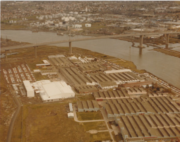 Port Melbourne Historical & Preservation Society
Photograph - Aerial view of West Gate Bridge under construction, 1970 - 1979
Colour aerial photograph of West Gate Bridge completed. Aircraft factory and other industry in foreground. Williamstown and fuel storage tanks in background (Coode Island)"Gov't A/C Factories Photographic Section Neg No N2841/3" stamped on backtransport, engineering, engineering - bridges, fishermans bend, industry, west gate bridge, rotten row, williamstown, yarra river -
Port Melbourne Historical & Preservation Society
Photograph - Aerial view showing route of Lower Yarra Crossing Project (West Gate Bridge), Apr 1966
Black and white aerial photomap showing the proposed route of the Lower Yarra Crossing Project, later to become the West Gate Bridge and Freeway. April 1966'Lower Yarra Crossing Project' '296769'west gate bridge, transport - roads, engineering - bridges -
Port Melbourne Historical & Preservation Society
Photograph - Aerial view of the commencement of Appleton Dock, Aug 1925
Black and white aerial photo of Commencement of Appleton Dock and construction of new river berths, with caption, both pasted onto paper with chequered computer bordertransport - shipping, piers and wharves, yarra river, appleton dock -
Port Melbourne Historical & Preservation Society
Photograph - Aerial view of American destroyers at Victoria Dock, 6 Aug 1925
Copy of aerial photo of Victoria Dock 1925 with destroyers from visiting American fleet, with caption, both pasted onto paper with chequered computer bordertransport - shipping, piers and wharves - miscellaneous, victoria dock -
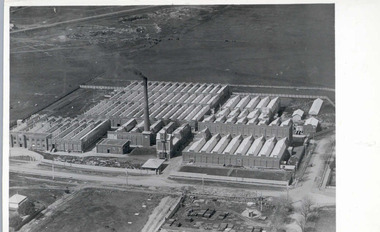 National Wool Museum
Photograph - Valley Worsted Mill, 1923
Photographic postcard depicting the newly constructed Valley Worsted Mill, c.1923.Photographic postcard, black and white. Depicts an aerial view of the newly constructed textile mill. A chimney stack and many saw toothed roofs can be seen.POST CARD / CORRESPONDENCE ADDRESS ONLY / KODAK / AUSTRALtextile mills, valley worsted mill foster valley mill pty ltd, aerial photography, factory, wool, industrial building -
Whitehorse Historical Society Inc.
Document, A Plan for Mitcham, 1960s
Mitcham chamber of Commerce pamphlet plans for developing Mitcham Shopping Centre to provide off-road parking. Aerial view illustration of shopping centre on cover.Mitcham chamber of Commerce pamphlet plans for developing Mitcham Shopping Centre to provide off-road parking. Aerial view illustration of shopping centre on cover.Mitcham chamber of Commerce pamphlet plans for developing Mitcham Shopping Centre to provide off-road parking. Aerial view illustration of shopping centre on cover.parking, mitcham shopping centre, armstrong, raleigh edward, colombo street, mitcham, elizabeth street, mitcham, mitcham road, mitcham, whitehorse road, mitcham, mitcham chamber of commerce -
Whitehorse Historical Society Inc.
Map, Springvale Road, 1990
Aerial photograph of cnr Springvale Road and Burwood Highway, south past Highbury Road, west to Middleborough Road and east to Morack Road Vermont South.Aerial photograph of cnr Springvale Road and Burwood Highway, south past Highbury Road, west to Middleborough Road and east to Morack Road Vermont South.Aerial photograph of cnr Springvale Road and Burwood Highway, south past Highbury Road, west to Middleborough Road and east to Morack Road Vermont South.aerial photographs, morack road, vermont south, burwood highway, burwood east, springvale road, burwood east, highbury road, burwood east, burwood east, vermont south -
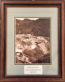 Tramways/East Melbourne RSL Sub Branch - RSL Victoria Listing id: 27511
Picture, Bukit Knuckle
Framed print of a sepia photograph showing the camp at 'Bukit Knuckle', an operational base of the 3RAR in Borneo. Images shows an aerial view of the camp and surrounding landscape. Underneath the print is added 'BUKIT KNUCKLE' B COV 3RAR OPERATIONAL BASE, BORNEO 1965 On reverse is marked 'Donated by Keith Matthews 1995'bukit knuckle, sungei koemba, 3 rar, indonesia malaysia confrontation -
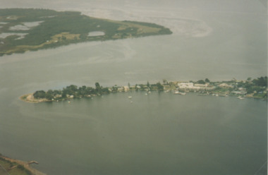
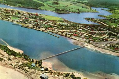 Lakes Entrance Historical Society
Photograph - Lakes Entrance, 1975c
Copied from postcardColour photograph aerial view of the township, also showing North Arm, Cunninghame Arm, footbridge, and kiosk and Lifesaving Club on hummocks. Lakes Entrance Victoriawaterways, township, islands, jetties, aerial photograph -
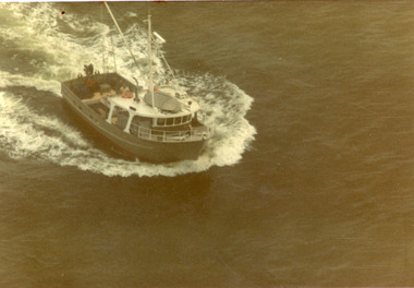 Lakes Entrance Historical Society
Photograph - Tarpeena, Hammarstrom Ian, 1986 c
Colour aerial photograph of the fishing boat Tarpeena in Bass Strait, taken from Colin Campbells aircraft, fish spotting from Lakes Entrance, Victoria.ships and shipping, fishing industry, ocean -
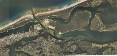 Lakes Entrance Historical Society
Photograph - Lakes Entrance, Gippsland Ports, 2006 c
Colour aerial photograph showing view of entrance to Gippsland Lakes from Bass Strait Reeves Channel Rigby Island and township of Lakes Entrance Victoriaaerial photograph, historic site, dredging, waterways, lakes entrance -
 Lakes Entrance Historical Society
Photograph - Metung, 1995 c
Colour aerial photograph of Shaving Point Gippsland Lakes with Mosquito Point bottom left hand corner Boole Poole on opposite shore Metung Victoriaaerial photograph, waterways, topography, metung -
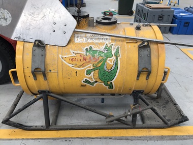 Department of Energy, Environment and Climate Action
Aerial Drip Torch (ADT) or "Dragon"
The Aerial Drip Torch (ADT) was an idea conceived in Canada in the 1970s by John Muraro It was developed in 1982 by the New Zealand Forest Service to become the Ashley Aphid Helitorch. Forestry Tasmania acquired one of the machines and modified it in February 1987. Also known as a dragon helitorch it consisted of a large 135-litre tank containing jellied petrol, a displacement pump, propane ignition system, burner nozzle and fire extinguisher system. It was first trialled in Victoria at Swifts Creek in 1991 and the Aerial Drip Torch (ADT) has now become standard practice.Two Aerial Drip Torches (ADTs) were built in the 1990s by the Fire Equipment Development Centre at North Altona, They were developed in conjunction with the Department of Conservation and Land Management in Western Australia. The first was trialled during the 1991/92 autumn burning season. The machine proved to be successful and a second machine was introduced in 1998 to assist with burning operations across the State. The ADTs were commonly used for regeneration burning (controlled burning of logging slash). The first ADT introduced in 1992 had a dry weight of 160kg and a capacity of 130 litres, providing about an hour of operation. Following initial use, systematic modifications were adapted including improved ignition of gel at the drop tube, installation of an air bleed valve at the pump to assist pump priming and improved mounting brackets for the CO2 bottles and propane canister attached to the machine. The second, and lightweight ADT, introduced in 1998 had a dry weight of 68kg and a capacity of 200 litres due to a smaller lightweight frame and plastic (Polyfin) tank. In operation the ADT is suspended below a helicopter via four strops attached to the vessel and a cable to the helicopter cargo hook. Gelled fuel is dispensed via a drop tube which is attached to the pump outlet of the machine, and ignited via a gas torch. Safety features built into the first ADT were: a brass melting plug designed to be activated at 200 C bursting disc designed to burst at170 Kpa should the vessel over pressurise. a pressure relief valve set to 35 Kpa ( vessel operated between 16 &34 Kpa) a low pressure sensor designed to shut down the machine should the vessel pressure drop below 15Kpa. the vessel is filled with CO2 above the gelled fuel to eliminate ignition with in the vessel. CO2 is used to expel any residue of ignited gel from the drop tube to prevent ignition when flying outside the boundaries of the burning area. See FIRE EQUIPMENT NOTE - 46 [ https://drive.google.com/file/d/1CKtcH-3rUlrtbE9dkNP27PYT2-raVVhF/view ]forests commission victoria (fcv), bushfire, bushfire aviation, planned burning -
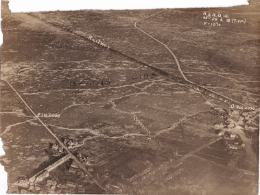 The Beechworth Burke Museum
Photograph, c1914
Aerial photograph of a battle field in France during World War OneBlack and white rectangular photograph printed on photographic paperObverse: Railway / British Line (in pen) / Reverse: Villers Brut /military album, burke museum, beechworth, beechworth museum, world war one, wwi, trenches, aerial photo, aerial photo trenches -
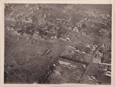 The Beechworth Burke Museum
Photograph, c1914
Aerial photograph of a battle field in France during World War OneBlack and white rectangular photograph printed on photographic paperReverse: 6534 / Australian Official Photographs, No. E1253 /military album, burke museum, beechworth, beechworth museum, world war war, wwi, trenches, aerial photo, battlefield -
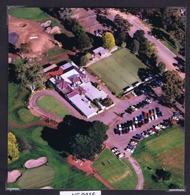 Heidelberg Golf Club
Photograph - Aerial Photograph, Heidelberg Golf Club 1998, 1998
Aerial view of the Heidelberg Golf Club, clubhouse, bowling green and carpark.Colour photograph.hgc clubhouse 1998, aerial photographs -
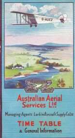 Bendigo Historical Society Inc.
Document - BASIL WATSON COLLECTION: AUSTRALIAN FLIGHT TIMETABLES, a. & b. 1927/29; c. 1927?
Australian Flight Timetables,3 booklets: 1. Australian Aerial Services Ltd. booklet contains timetables, educational notes on aerial transport, first flight impressions, coach connections with airports, rules of the air, 1920's although no date on booklet. Aerial route map shows route from Melbourne to Hay, then to Adelaide, and east to Cootamundra. 2. AHS Timetable and general information booklet. Issued 1st March 1929, contains timetables, general information re flights, image of passengers 'emplaning' at Essendon Airport. 3. 'Fly There' booklet of timetable information and passenger fares and parcel rates. West Australian Airways.person, individual, basil watson -
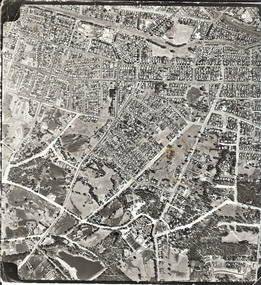 Bendigo Historical Society Inc.
Photograph - AERIAL SURVEY BENDIGO BASE MAP - RUN 12
Black and white photograph which is an aerial survey Bendigo base map - run 12. Inscriptions: Vic 1583. State Aerial Survey Bendigo Base Map Project - Run 12. 16/3/1967, 5600ASL on front. The photograph shows areas of Kennington and Flora Hill. Title of map to be held at right hand side. Streets identifiable from 'Five Ways' intersection.place, aerial view of bendigo -
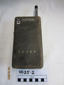 Wannon Water
Two way radio, Hayakawa Electric Co., Ltd Japan
Front and back cover made of metal and held together at the back with a screw. Push Button on the left (Press to Talk), also red wheel for turning transistor on and adjusting volume. Aerial on the right at the top. Aerial 1.40 m long when extended. Front cover has inbedded a silver square metal mesh for hearing sound and speaking. Brown leather cover with zip for protection.Front: 9 Transistor/Sharp/ Model CBT-1A Back: Earphone/ Press to Talk/ Made in Japan Handwritten on a piece of tape: Batteries replaced 1-5-1968, 6-6-1975 -
 Kiewa Valley Historical Society
Photograph - Mt Beauty timber Industries, 1960's (estimate only)
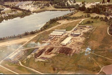
Hume and Hovell discovered the area in 1824 and by the end of the 19th century the valley was transformed by logging, dairy and beef cattle properties and tobacco farms. Timber was required for construction of McKay Creek Power Station which began construction in 1951 and also the camps and houses for the workers and their families. There was a need for housing and infrastructure for an increasing population of workers for the hydro-electric scheme as there was a general shortage of this commodity. A timber mill was started in Tawonga by Mates, of Albury, in 1945, and electricity became available in 1946 the S.E.C. bought the mill, and enlarged it. In 1960 it was purchase by a local family. They also started a timber mill in Mt Beauty and worked both until 1980 when they closed the Tawonga mill and enlarged the mill called Mt. Beauty Timbers Pty Ltd which employed approximately 50 people. A pictorial record of the development of the Mt Beauty community and the local timber industry.Colour photograph of aerial view of Mt Beauty Timber Mills and surrounding area including pondage and part of airfield. Photo taken in 1960’s (estimate only)Handwritten in ink on back of photograph in very faint writing – Recent photo of Mt Beauty Timber Industries Mt Beauty Operationsmt beauty timber industry, timber industry, timber mill, secv -
Glenelg Shire Council Cultural Collection
Photograph - Photograph - Aerial view from NE Portland Harbour, c. 1967
Port of Portland Authority archives.Front: 19 June 1997 Back: 19 June 1997port of portland archives -
Glenelg Shire Council Cultural Collection
Photograph - Photograph - Cape Grant Quarry, 24/01/1968
Port of Portland Authority archives.Back: 'JAN 24, 1968' - pencil top rightport of portland archives, cape grant quarry -
Glenelg Shire Council Cultural Collection
Functional object - Folder, promotional, E.Davis & Sons Pty Ltd. Portland 3305, c. 1980
Promotional folder (folded but not fully constructed) with wrap-around aerial image of Portland (c.1980). On the front is printed, 'Welcome to Portland' Black & white, with white text.Front: Welcome to Portland growth area in the 80's Back: Photograph courtsey of Portland Harbour Trust Printed by E. Davis & Sons Pty. Ltd. Portland, 3305promotion, portland, tourism -
Glenelg Shire Council Cultural Collection
Photograph - Photograph - aerial view of Portland, c. 1954
Black and white aerial photograph of coastline around Portland. Black border, scale all sides, 5 rows of 3 't' at regular intervals. All oceanFront: '784 - 156- handwritten, white, border 'RUN 7 A PORTLAND', printed, white, borderaerial photography, central portland, portland harbour, south west coastline -
Glenelg Shire Council Cultural Collection
Photograph, View of Portland Harbour, c. 1974
Port of Portland Authority archives.Front: (no inscriptions) Back: (no inscriptions) -
Glenelg Shire Council Cultural Collection
Photograph, View of Portland Harbour, c. 1974
Port of Portland Authority archives.Front: (no inscriptions) Back: (no inscriptions)port of portland, henty park, fishing fleet