Showing 3604 items
matching background history
-
 Glenelg Shire Council Cultural Collection
Negative - Glass Plate Negative - Afternoon Tea, Portland, 1890-1910
Glass plate negative. Three ladies seated at a table, 'taking tea'. Wall covered with creeper in background. Dress late 19th, early 20th Century.tea, recreation, ladies, women -
Glenelg Shire Council Cultural Collection
Souvenir - Souvenir Teaspoon, n.d
Boxed spoon, metal, silver coloured scalloped. Enamelled badge, green tree on blue background. Heywood, Vic.souvenir, heywood, glenelg shire -
Glenelg Shire Council Cultural Collection
Photograph - Photograph - Henty Monument Ploughed Field Portland, Victoria, n.d
Black and white photo. Henty monument in background, Ploughed FieldBack: '56' in pencil -
Glenelg Shire Council Cultural Collection
Negative - Glass Plate Negative - Picnic scene, c. 1890
Glass plate negative. Image sgows a group of 2 men and 4 women, sitting on rugs 'picnicking' on banks of a river. Buggy in background. -
Glenelg Shire Council Cultural Collection
Negative - Glass Plate Negative - Bridge across Salt Creek with 'Kingsley' in background, c. 1890
Glass plate negative. Image shows the bridge across Salt Creek with 'Kingsley' in background. -
 Greensborough Historical Society
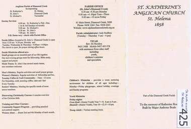
Leaflet, St Katherine's Anglican Church St Helena 1858, 1858o
Contains a history of St Katherine's Church St Helena, Major Anthony Beale and his wife Katherine Rose after whom the church and chapel are named. Includes current parish information and contacts. [Rev Di Nicolios become rector of St John's parish in Diamond Creek in 2002]Background to this well known pioneer church.One A4 page, folded in 3. Printed on buff coloured paper.st katherines church, st helena, anthony beale, rose chapel -
 Greensborough Historical Society
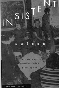
Book, Insistent voices: the story of the Diamond Valley Learning Centre. By Michele Lonsdale, 1993_
This is the history of the Diamond Valley Learning Centre published to celebrate its first 20 years. It traces the rise of community education and the women's movement in the 1970s and '80s. Personal recollections combine with historical background.This centre is an important landmark in the Diamond Valley and this book relates the DVLC to those who live in the area.Paperback; 147 p., illus. Grey cover with white print, photograph of students at DVLC.diamond valley learning centre, community neighbourhood house, greensborough, adult education -
 Greensborough Historical Society
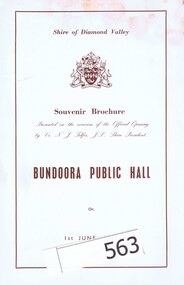
Booklet and List, Shire of Diamond Valley, Bundoora Public Hall Souvenir Brochure, 01/06/1968
2 Souvenir booklets from the official opening of Bundoora Public Hall on 1st June 1968. One is in original unopened commemorative envelope featuring the coat of arms of the Shire of Diamond Valley. The brochure opens to a 3 page double sided document outlining the history of the original public hall in Bundoora, describing the new building and also shows a plan of the same. Accompanied by a 9 page foolscap list of guests at the opening. Entries are mostly typed, but some have been added by hand. Records the attendees at and program for opening of Bundoora Public Hall. The list of names includes many prominent Diamond Valley people.History of Bundoora Public Hall and the previous hall built in 1923.Booklet and list. The print is in red brown ink on a background that is variously white or blue.bundoora public hall, bundoora, neville telfer, w a anderson, shire of diamond valley -
 Halls Gap & Grampians Historical Society
Photograph - B/W
This photo is of the original Halls Gap Public Hall. For a history of the hall see record 389.The photo shows a large weatherboard building. The right hand side has a pitched roof and a small entrance area, also with a pitched roof. The left hand side is square and has a flat roof. There is a sign on the left hand side which reads "Halls Gap Public Hall". There are two cars parked near the hall and the framework of another structure, and a gum tree, can be seen to the far left. There is a range visible in the background, and a muddy road/track in the foreground.buildings, halls -
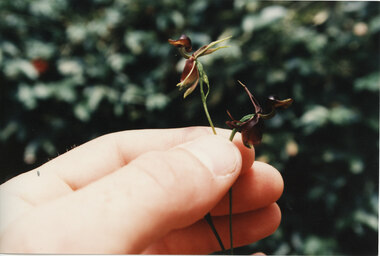 Halls Gap & Grampians Historical Society
Photograph - Coloured
Photo shows a close up of a person holding two flowers which look like ducks (Duck Orchids) between their fingers. There is a muted background of foliage.natural history, flora -
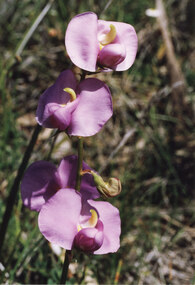 Halls Gap & Grampians Historical Society
Photograph - Coloured
This is a photo of Swainsonia Procumbens (Broughton pea).The photo shows a close-up of a specimen of native pea. The flower is bright mauve with green/yellow stamens. The background is out of focus foliage/grasses.natural history, flora -
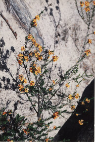 Halls Gap & Grampians Historical Society
Photograph - Coloured, C Jan 1987
The photo shows a close-up of a specimen of native pea. The plant has many small flowers and leaves. The flowers are gold in colour with orange/brown (redish) centres. A large gum trunk or branch of a very pale colour forms the background.natural history, flora -
 Halls Gap & Grampians Historical Society
Photograph - Coloured
The photo shows a close-up of a specimen of native pea. Four flowers are clearly visible on the plant; they are pale lemon/green with purple brown stamens and colouring. The two lower flowers are not fully open. The background is blurred and consists of unidentifiable plants/foliage in greens, browns and orange.natural history, flora -
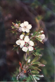 Halls Gap & Grampians Historical Society
Photograph - Coloured
This is a photo of Leptospermum Turbinatum (Shining Tea-tree).Photo shows a close-up view of a native flower (tea-tree).The flower has five white petals with small dark pink/red centre petals. Small, red tipped, green leaves surround the flower and can be seen on the stems. The background is out of focus.natural history, flora -
 Halls Gap & Grampians Historical Society
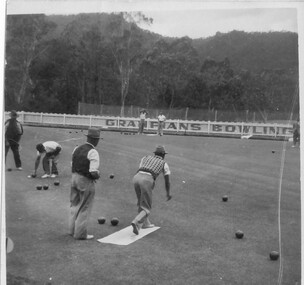
Photograph - B/W
See History Walk Brochure.A group of men playing bowls. There are 7 men on the bowling green with one actually bowling. A white picket fence is in the distance. The words "Grampians Bowling" are painted on the fence. A mountain range is in the background.recreation, lawn bowling -
 Halls Gap & Grampians Historical Society
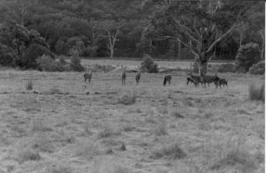
Photograph - Coloured, C 1980s
Photo is located on Fyans Valley floor below Bellfield dam,Photo is of nine deer in a grassy paddock with bushland at the rear. A large gumtree stands middle foreground. A dead gumtree stands in the background,Fujicolor papernatural history, feral animals -
4th/19th Prince of Wales's Light Horse Regiment Unit History Room
Plaque, B Sqn 4/19 PWLH
Plaque, small shield depicting red Welsh dragon on yellow background with motto "Sin Loi". All mounted on wooden shield shaped backing, with title on scroll - 'B' Sqn 4th/19th PWLHplaque -
4th/19th Prince of Wales's Light Horse Regiment Unit History Room
Plaque, Support Sqn 4/19 PWLH
Plaque, On small shield, Support Squadron badge consisting of black eagle on background of red over yellow Armoured Corps colours, diagonally divided. Mounted on larger wood shield. On scroll "SPT SQN 4th/19th PWLH"plaque -
4th/19th Prince of Wales's Light Horse Regiment Unit History Room
Plaque, 1st Aust Task Force
Plaque. Varnished wood shield on which affixed: Badge of 1 Australian Task Force (South Vietnam) comprising red kangaroo on green background, Name plate "FIRST AUSTRALIAN TASK FORCE" and flags on either side of badge - Australian & South Vietnamplaque -
 Ararat & District Historical Society (operating the Langi Morgala Museum)
Photograph
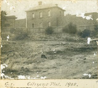
Record of local historyA series of three black and white photographs of the Citizens Plot at Alexandra Gardens. 501 shows the bluestone building J Ward standing behind a wooden picket fence with bare earth in front. 502 shows men in suits standing with three horses attached to two wagons with large trees in the background. 503 shows plants that have grown in the Citizens Plot garden.501: Citizens Plot 1908 502: Citizens Plot 1909. 503: Citizens Plot showing growth 1921. -
 Eltham District Historical Society Inc
Photograph, Spring Excursion, Hume and Hovell bus tour Stage 2, Seymour, Benalla; 26 Oct 1997, 26/10/1997
MONUMENT HUNTING THE HUME AND HOVELL WAY (Newsletter No. 117, November 1997, by Diana Bassett-Smith) Sunday October 26 1997 dawned bright and very warm. Some twenty-five members, complete with picnic baskets, met outside the Eltham Library awaiting the Cobb and Co. large coach which would be taking us on the second leg of our travels along the route of the early explorers Hume and Hovell. Stephen West was our very good driver for the day. He would be guided around the circuitous route by Russell Yeoman wh9 had made a detailed study, not only of the intended route, but of the story of these two explorers. During the trip Russell regaled us with poetry, quotations from the Journals and the History of the Shire of Seymour, "The New Crossing Place: by Martindale, 1982, (now Mitchell Shire due to the recent amalgamations). We headed towards the Hume Highway via Greensborough and Cooper Street and proceeded north to our first stop, noting on the way Monument Hill in the distance which is near Kilmore and, according to Russell, well worth the effort to visit as the view across the valley is magnificent. Past Sunday Creek Valley, Mt Piper and Mt Disappointment, all traversed and noted and named by them. We passed through Tallarook, then onto Seymour where we took photos of the monument telling us that Hume and Hovell had passed through on the 28th of October 1824. We also deviated down Hume and Hovell Road viewing deer and emu farming and the Bellbourie property now a sanctuary. Leaving Seymour behind we travelled up the Avenel Road to the Avenel monument, pyramidal in design of four reducing square blocks with a sharply pointed peak, erected in 1924 in memory of the 1824 exploration. The day was warming up and the countryside showing the dryness of the current drought. A parallel note had been made in their journal too of 1824 of the drought appearance of the country they were traversing. At Seven Creeks, Euroa we stopped for some minutes to check the monument placed 20th November 1924 to commemorate their passage on the 29th December 1824. More photos. Russell had pointed out the abrupt termination of the distant ranges which is noted in their journal. The next monument is beside the road at the entrance to Honey Suckle Creek Caravan Park, Violet Town. The squarish shaped monument some eight feet high is topped with a simple steel cross, and was to mark the date of 28th December 1824 and built for the 20th November 1924. By now it was 12.20 and nearly lunchtime as we drove along the Warranbayne Road to Roach's Road, monument hunting without success. Though there is a large, what appears to be an old timber sign which was hard to read, maybe this was the lost monument. In many of the paddocks hay had been cut and baled or was being cut, what a contrast to the rugged country they had passed through which was smoky from the fires of the natives burning off By 1.00 pm we were at Benalla and pulled up beside the park where abundant beds of roses filled the air with their scent and the smell of barbecued food twitched the nostrils whilst the cheerful sounds of other picnickers could be heard throughout the park. We left the bus and collected up our picnics, dispersed to the various tables and enjoyed the shade from the various European trees. 2.00 pm and we were on the road again driving along the Benalla, Mansfield, Yea road. The Swanpool monument states that they passed four miles south and returned three miles north. Then we stopped at the Barjarg monument which notes that they camped near this spot. It is again a pyramidal monument and this time topped with a steel arrow indicating their route of the 29th November 1824. Half an hour later we came to another monument, again with a steel arrow marker on top and the plaque dated the 2nd of 12th 1824. Erected on the 12th of 12th 1924. "They blazed the way that we might inherit the land." Another square based and needle topped monument appeared at Yarck near Yea and this plaque records the date of 3 December 1824. Near McGuigans Road Russell related that the expedition had lost a dog but it had found them next day, the dog was apparently torn by a kangaroo. A short while later Russell reminded us here of the problems they encountered in crossing the Goulburn River near Molesworth where banks were high, water deep and wide. "Good coat of grass but quite dry due to drought". At Yea we stopped for afternoon tea and raided the last of our picnics and looked at the monument to their journey of 1824, situated at a corner of the gardens near the bowling green. No photo – we were out of film. We returned home via Kinglake West and Whittlesea past the Yan Yean Reservoir, not full. 5.00 pm back at Eltham we emptied out of the bus and everyone, including Joan Cole, collected their things, Joan also had the major souvenir of the day, a large carp she had picked up from the river bank, her cat was in for a great feast. The day was made so interesting by the informed commentary which Russell provided. His background knowledge of the route and nature of the journey could only have come from many hours of reading and driving the area. Thank you to Russell and to everyone who made the day so informative and pleasurable. Diana Bassett-Smith. Record of the Society's history of activities - Spring 1997 excursionRoll of 35mm colour negative film, 6 stripsFuji 200shire of eltham historical society, activities, pretty hill, seymour, benalla, hume and hovell, monuments -
 Eltham District Historical Society Inc
Photograph, Spring Excursion, Hume and Hovell bus tour Stage 2, Seymour, Benalla; 26 Oct 1997, 26/10/1997
MONUMENT HUNTING THE HUME AND HOVELL WAY (Newsletter No. 117, November 1997, by Diana Bassett-Smith) Sunday October 26 1997 dawned bright and very warm. Some twenty-five members, complete with picnic baskets, met outside the Eltham Library awaiting the Cobb and Co. large coach which would be taking us on the second leg of our travels along the route of the early explorers Hume and Hovell. Stephen West was our very good driver for the day. He would be guided around the circuitous route by Russell Yeoman wh9 had made a detailed study, not only of the intended route, but of the story of these two explorers. During the trip Russell regaled us with poetry, quotations from the Journals and the History of the Shire of Seymour, "The New Crossing Place: by Martindale, 1982, (now Mitchell Shire due to the recent amalgamations). We headed towards the Hume Highway via Greensborough and Cooper Street and proceeded north to our first stop, noting on the way Monument Hill in the distance which is near Kilmore and, according to Russell, well worth the effort to visit as the view across the valley is magnificent. Past Sunday Creek Valley, Mt Piper and Mt Disappointment, all traversed and noted and named by them. We passed through Tallarook, then onto Seymour where we took photos of the monument telling us that Hume and Hovell had passed through on the 28th of October 1824. We also deviated down Hume and Hovell Road viewing deer and emu farming and the Bellbourie property now a sanctuary. Leaving Seymour behind we travelled up the Avenel Road to the Avenel monument, pyramidal in design of four reducing square blocks with a sharply pointed peak, erected in 1924 in memory of the 1824 exploration. The day was warming up and the countryside showing the dryness of the current drought. A parallel note had been made in their journal too of 1824 of the drought appearance of the country they were traversing. At Seven Creeks, Euroa we stopped for some minutes to check the monument placed 20th November 1924 to commemorate their passage on the 29th December 1824. More photos. Russell had pointed out the abrupt termination of the distant ranges which is noted in their journal. The next monument is beside the road at the entrance to Honey Suckle Creek Caravan Park, Violet Town. The squarish shaped monument some eight feet high is topped with a simple steel cross, and was to mark the date of 28th December 1824 and built for the 20th November 1924. By now it was 12.20 and nearly lunchtime as we drove along the Warranbayne Road to Roach's Road, monument hunting without success. Though there is a large, what appears to be an old timber sign which was hard to read, maybe this was the lost monument. In many of the paddocks hay had been cut and baled or was being cut, what a contrast to the rugged country they had passed through which was smoky from the fires of the natives burning off By 1.00 pm we were at Benalla and pulled up beside the park where abundant beds of roses filled the air with their scent and the smell of barbecued food twitched the nostrils whilst the cheerful sounds of other picnickers could be heard throughout the park. We left the bus and collected up our picnics, dispersed to the various tables and enjoyed the shade from the various European trees. 2.00 pm and we were on the road again driving along the Benalla, Mansfield, Yea road. The Swanpool monument states that they passed four miles south and returned three miles north. Then we stopped at the Barjarg monument which notes that they camped near this spot. It is again a pyramidal monument and this time topped with a steel arrow indicating their route of the 29th November 1824. Half an hour later we came to another monument, again with a steel arrow marker on top and the plaque dated the 2nd of 12th 1824. Erected on the 12th of 12th 1924. "They blazed the way that we might inherit the land." Another square based and needle topped monument appeared at Yarck near Yea and this plaque records the date of 3 December 1824. Near McGuigans Road Russell related that the expedition had lost a dog but it had found them next day, the dog was apparently torn by a kangaroo. A short while later Russell reminded us here of the problems they encountered in crossing the Goulburn River near Molesworth where banks were high, water deep and wide. "Good coat of grass but quite dry due to drought". At Yea we stopped for afternoon tea and raided the last of our picnics and looked at the monument to their journey of 1824, situated at a corner of the gardens near the bowling green. No photo – we were out of film. We returned home via Kinglake West and Whittlesea past the Yan Yean Reservoir, not full. 5.00 pm back at Eltham we emptied out of the bus and everyone, including Joan Cole, collected their things, Joan also had the major souvenir of the day, a large carp she had picked up from the river bank, her cat was in for a great feast. The day was made so interesting by the informed commentary which Russell provided. His background knowledge of the route and nature of the journey could only have come from many hours of reading and driving the area. Thank you to Russell and to everyone who made the day so informative and pleasurable. Diana Bassett-Smith. Record of the Society's history of activities - Spring 1997 excursionRoll of 35mm colour negative film, 6 stripsFuji 200shire of eltham historical society, activities, pretty hill, seymour, benalla, hume and hovell, monuments