Showing 8371 items matching "bridges"
-
 Ballarat Tramway Museum
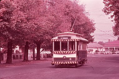
Slide - 35mm slide/s - set of 2 - Bendigo 6, Noel Simons, Apr. 1967
Set of 2 slides made from the Association of Railway Enthusiast Provincial Tramways film strip, possibly during April 1967. 1191.1 - No. 6 heading for North Bendigo in Bridge St., just past the disused Bridge St. Loop. See item 9449 for a print of this photo. 1191.2 - Bendigo 16 and 17 in the depot. Photo taken inside the building. No. 16 showing Thorpe St., 17 - Depot.1191.1 - "No. 6 passes the disused Bridge St. loop on its path to North Bendigo" - dated with a hand stamp in purple ink "Apr 1967". 1191.2 - "No. 16 and 17 at rear of Bendigo Depot". - slide not dated - late 60's or early 70's. Details are in blue ink written onto slide mount.tramways, trams, north bendigo, bendigo, bridge st loop, depot, tram 6, tram 16, tram 17 -
 Melbourne Legacy
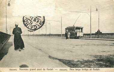
Postcard, New bridge at Rodah, c.1912
Postcards were a common form of souvenirs for soldiers who were travelling either during World War 1, or just after, or while returning to Australia. Was with other World War 1 memorabilia that has come from Private John Basil McLean, 2nd Reinforcements, 37th Battalion, A.I.F. J.B. McLean (Service No. 13824) was from near Maffra, Victoria and enlisted on 22 January 1916. He embarked on 16 December 1916 for Europe. His full war record is available from AWM. He spent time with the Australian Field Artillery (Pack Section). At the end of the war he worked for a year at the A.I.F. Headquarters in London before returning to Australia on the 'Ceramic', arriving Portsea in 1920.Postcards were a very common form of communication in the first World War. This postcard also records Gallipoli for those who didn't have cameras. This type of souvenir would have been familiar to the first Legatees as they had served in World War 1 and many had served at Gallipoli.Postcard showing black and white image of the bridge at Rodah, Guizeh (Giza). Several figures and a tram are also pictured crossing the bridge. A black postal stamp in the top left quadrant of the postcard indicates it was posted from Cairo. The back of the postcard contains a message. Based on the date and location it was posted from, the text could be Egyptian Arabic or it could be Pitman shorthand.Front - “(Guizeh) Nouveau grand pont de Rodah - (Guizeh) New large bridge at Rodah.” Back - “J/15/1912/ CARTE POSTALE / M J?. Hinaul / 20 Rue de Landrecies/ Le Cateau (Nord)/ France/ Ghino Dukich, 21 Rue Nubar Pacha - Le Caire, Egypte/ Serie A No. 25. Reproduction interdite” Stamps - Postes Egyptiennes/ Un Millieme”souvenir, war correspondence -
 Eltham District Historical Society Inc
Photograph, Russell Yeoman, Fitzsimons Lane Bridge over Yarra River between Eltham and Templestowe, c.1970, 1970c
... bridges ...The bridge over the Yarra River was initially opened September 22nd, 1961. Newspaper reports at the time of opening stated it linked Bolton Street, Eltham, with Fitzsimons Lane, Templestowe. In 1955 the Country Roads Board (CRB) produced survey plans that showed proposed land acquisition for the future bridge and road approaches. The 1955 plan shows that it was proposed to connect Fitzsimons Lane with Bolton Street in Eltham by a diagonal road across the river. The road connection would then continue along Bolton Street to Main Road. Prior to construction of the bridge the CRB modified the proposal significantly so that there was a new road parallel with Bolton Street and then curving to join Main Road at what was then its intersection with Old Eltham Road. This involved significantly more land acquisition and altered the pattern of land subdivision through this corridor. Initially the new road was just a single two-way carriageway as it would have required a significant widening of the cutting on the Shire of Eltham side of the river. The road was officially un-named but was known locally as the Eltham-Templestowe Road. The 1966 Melway street directory and other 1960s editions also listed the road as the Eltham-Templestowe Road. In December 1970, Eltham Shire Council, in pursuance of the provisions of the Local Government Act, named it Templestowe Road. The road was renamed Fitzsimons Lane around 1984 in conformity with the section south of the river. In 1991 a new bridge was built to the west of the original bridge. Fitzsimons Lane was widened to four traffic lanes although on the Eltham side this was done within the limits of the existing cutting. NEW BRIDGE STARTS THEM EXPLORING Without any fanfares, Country Roads Board workmen on Friday afternoon put the finishing touches to the approaches, removed the barricades, and let the traffic roll over the new Yarra bridge linking Bolton Street, Eltham, with Fitzsimons Lane, Templestowe. Over the week-end many “bridge watchers” who were making one of their periodic inspections of the progress on the new bridge found to their surprise that they could drive over it, so that people who had gone for a run out to Eltham suddenly found themselves wandering through Templestowe and Doncaster. By Monday the word of the bridge’s opening had got around sufficiently for many regular travellers to the city from Eltham and beyond to vary the monotony by going to town via Templestowe and Kew instead of through Heidelberg. They were surprised at the distances – about 3 ½ miles from Eltham to Templestowe, 6 miles from Eltham Shire hall to the Lower Heidelberg Road-Banksia Street intersection. NEW NEIGHBOURS For people on both sides of the river, the new bridge has turned distant friends into near neighbours. A Greensborough man on Sunday took 35 minutes to reach the home of a friend in East Doncaster, but the return trip over the new bridge took only 17 minutes. It will be some time yet before most people work out the possibilities in shorter and quicker trips form the north-eastern areas to the eastern and south-eastern suburbs. The coming of the warmer months will soon teach many, though the short cuts to Peninsular beaches and eastern suburban drive-ins. And before very long it is likely there will be a Tramways bus running from Templestowe to Eltham station. NEW BRIDGE STARTS THEM EXPLORING (1961, September 27). The Diamond Valley News (News clipping held in SEA_74-1_047) The previously un-named road between Main Road and Yarra River, Eltham South, east of Bolton Street was named Templestowe Road, December 15, 1970 NAMING OF STREETS AND ROADS. (1970, December 15). The Diamond Valley News (News clipping held in SEA_74-2_022)Roll of 35mm black and white negative film, 4 of 7 stripsIlford HP4bridge, bridges, fitzsimons lane bridge, infrastructure, shire of eltham infrastructure, yarra river -
 Greensborough Historical Society
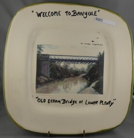
Plate, Serge Daeffler, Old Eltham Bridge at Lower Plenty, 1980s
Ceramic plate, decorated by Serge Daeffler. Hand painted text with transfer illustration of the Old Eltham Bridge at Lower Plenty which was opened on 8/3/1867.Ceramic plate, off-white with green edges, colour transfer photograph, glazed"Welcome to Banyule", "Old Etham (sic) Bridge at Lower Plenty", by Serge Daeffler. Card of Banyule's Heidelberg School Heritage Artist, Robert S, Phillips attached to rear, with price label from Savers.plates, lower plenty -
 Phillip Island and District Historical Society Inc.
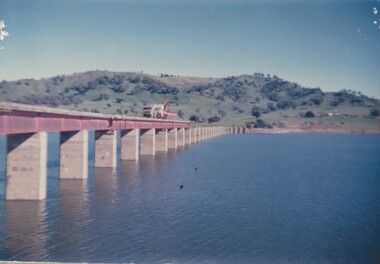
Photograph, 21/11/1969
... Bridges ...Photograph donated by Country Roads Board.Black & White Photograph showing the Official Opening of the second Phillip Island bridge, by Hon. M. V. Porter MLA, Minister of Public Works. November 21, 1969.local history, photography, photographs, slides, film, civil engineering, bridges, history of the phillip island bridge, black & white photograph, phillip island bridges -
 Southern Sherbrooke Historical Society Inc.
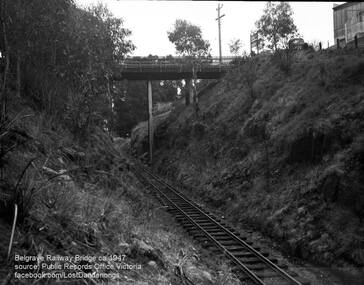
Photograph, Belgrave Railway Bridge, 1947
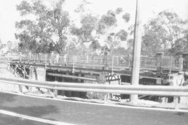
Belgrave Railway Bridge seen from near railway line on the east side. Photo shows the bridge over a scrubby railway cutting. There are small trees. A truck is parked on the right side of the bridge and perpendicular to the bridge. To the right is a building, presumably US Motors. A sign visible on right end of the bridge is also visible on VSSHP0069.02. -
 Ringwood and District Historical Society
Photograph, The old Warrandyte Road bridge viewed across bypass. Ringwood, 1986
Written on back of photograph, "29.11.86. The old bridge viewed across bypass." (Warrandyte Road bridge) -
 National Wool Museum
Pennant
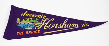
Souvenir Horsham vic. THE BRIDGEhorsham, victoria -
![Photograph - Construction of the F19 [Eastern Freeway], Ron Setford, January 1977](/media/collectors/550653872162f11fb04854aa/items/68287b8764071e7c58e66597/item-media/68287bc964071e7c58e66779/item-fit-380x285.jpg) Kew Historical Society Inc
Kew Historical Society IncPhotograph - Construction of the F19 [Eastern Freeway], Ron Setford, January 1977
Ron Setford and his wife Grace Setford lived in Tanner Avenue, East Kew, from c.1946 to c.1995. A keen photographer, he recorded the changing face of Kew over a 20 year period. Apart from 30 photographs of built structures and places in Kew dating from 1960 and 1961, 145 of his 35mm colour slides chronicle the development of the F19 (later renamed Eastern) Freeway through the Yarra Valley in Kew over a five year period from c.1972 to c.1977. This important collection was donated to the Society by his granddaughter in 2025.This collection of 175 35mm slides is of local and statewide significance, owing to its subject matter, particularly the major development of road transport infrastructure during the 1970s with the construction of the Eastern Freeway. The photographer also took care to annotate and date most of his slides which enable the researcher to pinpoint temporal and spatial locations."Freeway / Kew - Fairfield Bridges"ron setford, eastern freeway, f19 freeway -
![Photograph - Construction of the F19 [Eastern Freeway], Ron Setford, January 1977](/media/collectors/550653872162f11fb04854aa/items/6808c6dc025de50d1e73affc/item-media/6808c6f7025de50d1e73b2c2/item-fit-380x285.jpg) Kew Historical Society Inc
Kew Historical Society IncPhotograph - Construction of the F19 [Eastern Freeway], Ron Setford, January 1977
Ron Setford and his wife Grace Setford lived in Tanner Avenue, East Kew, from c.1946 to c.1995. A keen photographer, he recorded the changing face of Kew over a 20 year period. Apart from 30 photographs of built structures and places in Kew dating from 1960 and 1961, 145 of his 35mm colour slides chronicle the development of the F19 (later renamed Eastern) Freeway through the Yarra Valley in Kew over a five year period from c.1972 to c.1977. This important collection was donated to the Society by his granddaughter in 2025.This collection of 175 35mm slides is of local and statewide significance, owing to its subject matter, particularly the major development of road transport infrastructure during the 1970s with the construction of the Eastern Freeway. The photographer also took care to annotate and date most of his slides which enable the researcher to pinpoint temporal and spatial locations."Freeway / Kew Fairfield Bridges"ron setford, eastern freeway, f19 freeway -
![Photograph - Construction of the F19 [Eastern Freeway], Ron Setford, January 1977](/media/collectors/550653872162f11fb04854aa/items/6808c8dd025de50d1e73d331/item-media/6808c8ff025de50d1e73d73b/item-fit-380x285.jpg) Kew Historical Society Inc
Kew Historical Society IncPhotograph - Construction of the F19 [Eastern Freeway], Ron Setford, January 1977
Ron Setford and his wife Grace Setford lived in Tanner Avenue, East Kew, from c.1946 to c.1995. A keen photographer, he recorded the changing face of Kew over a 20 year period. Apart from 30 photographs of built structures and places in Kew dating from 1960 and 1961, 145 of his 35mm colour slides chronicle the development of the F19 (later renamed Eastern) Freeway through the Yarra Valley in Kew over a five year period from c.1972 to c.1977. This important collection was donated to the Society by his granddaughter in 2025.This collection of 175 35mm slides is of local and statewide significance, owing to its subject matter, particularly the major development of road transport infrastructure during the 1970s with the construction of the Eastern Freeway. The photographer also took care to annotate and date most of his slides which enable the researcher to pinpoint temporal and spatial locations."Freeway / Kew Fairfield Bridges"ron setford, eastern freeway, f19 freeway -
![Photograph - Construction of the F19 [Eastern Freeway], Ron Setford, January 1977](/media/collectors/550653872162f11fb04854aa/items/6808c850025de50d1e73cadc/item-media/6808c875025de50d1e73cdae/item-fit-380x285.jpg) Kew Historical Society Inc
Kew Historical Society IncPhotograph - Construction of the F19 [Eastern Freeway], Ron Setford, January 1977
Ron Setford and his wife Grace Setford lived in Tanner Avenue, East Kew, from c.1946 to c.1995. A keen photographer, he recorded the changing face of Kew over a 20 year period. Apart from 30 photographs of built structures and places in Kew dating from 1960 and 1961, 145 of his 35mm colour slides chronicle the development of the F19 (later renamed Eastern) Freeway through the Yarra Valley in Kew over a five year period from c.1972 to c.1977. This important collection was donated to the Society by his granddaughter in 2025.This collection of 175 35mm slides is of local and statewide significance, owing to its subject matter, particularly the major development of road transport infrastructure during the 1970s with the construction of the Eastern Freeway. The photographer also took care to annotate and date most of his slides which enable the researcher to pinpoint temporal and spatial locations."Freeway / Kew - Fairfield Bridges"ron setford, eastern freeway, f19 freeway -
![Photograph - Construction of the F19 [Eastern Freeway], Ron Setford, January 1977](/media/collectors/550653872162f11fb04854aa/items/683bd42569688f11138e678b/item-media/683bd46269688f11138e6862/item-fit-380x285.jpg) Kew Historical Society Inc
Kew Historical Society IncPhotograph - Construction of the F19 [Eastern Freeway], Ron Setford, January 1977
Ron Setford and his wife Grace Setford lived in Tanner Avenue, East Kew, from c.1946 to c.1995. A keen photographer, he recorded the changing face of Kew over a 20 year period. Apart from 30 photographs of built structures and places in Kew dating from 1960 and 1961, 145 of his 35mm colour slides chronicle the development of the F19 (later renamed Eastern) Freeway through the Yarra Valley in Kew over a five year period from c.1972 to c.1977. This important collection was donated to the Society by his granddaughter in 2025.This collection of 175 35mm slides is of local and statewide significance, owing to its subject matter, particularly the major development of road transport infrastructure during the 1970s with the construction of the Eastern Freeway. The photographer also took care to annotate and date most of his slides which enable the researcher to pinpoint temporal and spatial locations."Freeway / Kew Fairfield Bridges"ron setford, eastern freeway, f19 freeway -
![Photograph - Construction of the F19 [Eastern Freeway], Ron Setford, January 1977](/media/collectors/550653872162f11fb04854aa/items/683be0ac69688f11138ec21e/item-media/683be0d069688f11138ec49c/item-fit-380x285.jpg) Kew Historical Society Inc
Kew Historical Society IncPhotograph - Construction of the F19 [Eastern Freeway], Ron Setford, January 1977
Ron Setford and his wife Grace Setford lived in Tanner Avenue, East Kew, from c.1946 to c.1995. A keen photographer, he recorded the changing face of Kew over a 20 year period. Apart from 30 photographs of built structures and places in Kew dating from 1960 and 1961, 145 of his 35mm colour slides chronicle the development of the F19 (later renamed Eastern) Freeway through the Yarra Valley in Kew over a five year period from c.1972 to c.1977. This important collection was donated to the Society by his granddaughter in 2025.This collection of 175 35mm slides is of local and statewide significance, owing to its subject matter, particularly the major development of road transport infrastructure during the 1970s with the construction of the Eastern Freeway. The photographer also took care to annotate and date most of his slides which enable the researcher to pinpoint temporal and spatial locations."Freeway / Chandler Highway Bridges"ron setford, eastern freeway, f19 freeway -
![Photograph - Construction of the F19 [Eastern Freeway], Ron Setford, January 1977](/media/collectors/550653872162f11fb04854aa/items/683bdf5d69688f11138eb53e/item-media/683bdf7e69688f11138eb75a/item-fit-380x285.jpg) Kew Historical Society Inc
Kew Historical Society IncPhotograph - Construction of the F19 [Eastern Freeway], Ron Setford, January 1977
Ron Setford and his wife Grace Setford lived in Tanner Avenue, East Kew, from c.1946 to c.1995. A keen photographer, he recorded the changing face of Kew over a 20 year period. Apart from 30 photographs of built structures and places in Kew dating from 1960 and 1961, 145 of his 35mm colour slides chronicle the development of the F19 (later renamed Eastern) Freeway through the Yarra Valley in Kew over a five year period from c.1972 to c.1977. This important collection was donated to the Society by his granddaughter in 2025.This collection of 175 35mm slides is of local and statewide significance, owing to its subject matter, particularly the major development of road transport infrastructure during the 1970s with the construction of the Eastern Freeway. The photographer also took care to annotate and date most of his slides which enable the researcher to pinpoint temporal and spatial locations."Freeway / Chandler Highway Bridge"ron setford, eastern freeway, f19 freeway -
![Photograph - Construction of the F19 [Eastern Freeway], Ron Setford, January 1977](/media/collectors/550653872162f11fb04854aa/items/683be10f69688f11138ec6f1/item-media/683be12f69688f11138eca95/item-fit-380x285.jpg) Kew Historical Society Inc
Kew Historical Society IncPhotograph - Construction of the F19 [Eastern Freeway], Ron Setford, January 1977
Ron Setford and his wife Grace Setford lived in Tanner Avenue, East Kew, from c.1946 to c.1995. A keen photographer, he recorded the changing face of Kew over a 20 year period. Apart from 30 photographs of built structures and places in Kew dating from 1960 and 1961, 145 of his 35mm colour slides chronicle the development of the F19 (later renamed Eastern) Freeway through the Yarra Valley in Kew over a five year period from c.1972 to c.1977. This important collection was donated to the Society by his granddaughter in 2025.This collection of 175 35mm slides is of local and statewide significance, owing to its subject matter, particularly the major development of road transport infrastructure during the 1970s with the construction of the Eastern Freeway. The photographer also took care to annotate and date most of his slides which enable the researcher to pinpoint temporal and spatial locations."Freeway / River above bridges"ron setford, eastern freeway, f19 freeway -
![Photograph - Construction of the F19 [Eastern Freeway], Ron Setford, December 1977](/media/collectors/550653872162f11fb04854aa/items/683bd6c569688f11138e79b0/item-media/683bd70269688f11138e7b96/item-fit-380x285.jpg) Kew Historical Society Inc
Kew Historical Society IncPhotograph - Construction of the F19 [Eastern Freeway], Ron Setford, December 1977
Ron Setford and his wife Grace Setford lived in Tanner Avenue, East Kew, from c.1946 to c.1995. A keen photographer, he recorded the changing face of Kew over a 20 year period. Apart from 30 photographs of built structures and places in Kew dating from 1960 and 1961, 145 of his 35mm colour slides chronicle the development of the F19 (later renamed Eastern) Freeway through the Yarra Valley in Kew over a five year period from c.1972 to c.1977. This important collection was donated to the Society by his granddaughter in 2025.This collection of 175 35mm slides is of local and statewide significance, owing to its subject matter, particularly the major development of road transport infrastructure during the 1970s with the construction of the Eastern Freeway. The photographer also took care to annotate and date most of his slides which enable the researcher to pinpoint temporal and spatial locations."Boulevard Bridge North Kew"ron setford, eastern freeway, f19 freeway -
![Photograph - Construction of the F19 [Eastern Freeway], Ron Setford, January 1977](/media/collectors/550653872162f11fb04854aa/items/683bd4de69688f11138e6afa/item-media/683bd50569688f11138e6d14/item-fit-380x285.jpg) Kew Historical Society Inc
Kew Historical Society IncPhotograph - Construction of the F19 [Eastern Freeway], Ron Setford, January 1977
Ron Setford and his wife Grace Setford lived in Tanner Avenue, East Kew, from c.1946 to c.1995. A keen photographer, he recorded the changing face of Kew over a 20 year period. Apart from 30 photographs of built structures and places in Kew dating from 1960 and 1961, 145 of his 35mm colour slides chronicle the development of the F19 (later renamed Eastern) Freeway through the Yarra Valley in Kew over a five year period from c.1972 to c.1977. This important collection was donated to the Society by his granddaughter in 2025.This collection of 175 35mm slides is of local and statewide significance, owing to its subject matter, particularly the major development of road transport infrastructure during the 1970s with the construction of the Eastern Freeway. The photographer also took care to annotate and date most of his slides which enable the researcher to pinpoint temporal and spatial locations."Freeway / Kew - Fairfield Bridges"ron setford, eastern freeway, f19 freeway -
![Photograph - Construction of the F19 [Eastern Freeway], Ron Setford, January 1977](/media/collectors/550653872162f11fb04854aa/items/683bd56369688f11138e6e9c/item-media/683bd58d69688f11138e709a/item-fit-380x285.jpg) Kew Historical Society Inc
Kew Historical Society IncPhotograph - Construction of the F19 [Eastern Freeway], Ron Setford, January 1977
Ron Setford and his wife Grace Setford lived in Tanner Avenue, East Kew, from c.1946 to c.1995. A keen photographer, he recorded the changing face of Kew over a 20 year period. Apart from 30 photographs of built structures and places in Kew dating from 1960 and 1961, 145 of his 35mm colour slides chronicle the development of the F19 (later renamed Eastern) Freeway through the Yarra Valley in Kew over a five year period from c.1972 to c.1977. This important collection was donated to the Society by his granddaughter in 2025.This collection of 175 35mm slides is of local and statewide significance, owing to its subject matter, particularly the major development of road transport infrastructure during the 1970s with the construction of the Eastern Freeway. The photographer also took care to annotate and date most of his slides which enable the researcher to pinpoint temporal and spatial locations."Freeway / Kew - Fairfield Bridges"ron setford, eastern freeway, f19 freeway -
 Ballarat Tramway Museum
Photograph - Colour Print/s, Keith Kings, 13/03/2005 12:00:00 AM
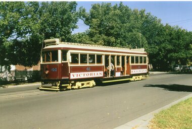
Colour print - of VR 41, in Bridge St Bendigo 13/3/2005, shortly after its reconstruction at Bendigo and re-commissioned for the MTPA - see note.In ink on the rear - Keith Kings stamp and "501-32", and "Melbourne Tramcar Preservation Association, Ex VR Tramcar 41 on an Exhibition trip in Bridge St Bendigo 13/3/05, shortly after it had been "launched" / recommissioned. Most of the restoration work was out by Bendigo Trust staff, under contract, with the not insignificant balance done by MTPS members"trams, tramways, mtpa, mtpa, bendigo, bridge st, restoration, vr trams, tram 41 -
 Melbourne Tram Museum
Photograph - Colour Print, Keith Kings, 13/03/2005 12:00:00 AM
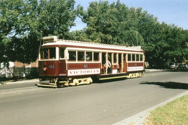
Colour print - of VR 41, in Bridge St Bendigo 13/3/2005, shortly after its reconstruction at Bendigo and re-commissioned for the MTPA - see note.In ink on the rear - Keith Kings stamp and "501-32", and "Melbourne Tramcar Preservation Association, Ex VR Tramcar 41 on an Exhibition trip in Bridge St Bendigo 13/3/05, shortly after it had been "launched" / recommissioned. Most of the restoration work was out by Bendigo Trust staff, under contract, with the not insignificant balance done by MTPS members"trams, tramways, mtpa, bendigo, bridge st, restoration, vr trams, tram 41 -
Glenelg Shire Council Cultural Collection
Photograph - Photograph - Bridge Construction, Portland, 04/10/1957
Port of Portland Authority ArchivesFront: Back- '4/10/57' - blue biroport of portland archives, canal bridge, construction, workmen -
Ballarat Heritage Services
Photograph - Photograph - Colour, Clare Gervasoni, Docwra Street Bridge, Magpie, Victoria, 2019, 18/05/2019
A bridge built over the Yarrowee Creek at Magpie. It replaced a single lane bridge and was built c2017.magpie, docwra street bridge -
 Wodonga & District Historical Society Inc
Photograph - Fred Rochow Railways Collection - Dismantling the Sandy Creek Bridge, 1987
The Fred Rochow Railways Collection incorporates photos related to the operation of the Wodonga Railway Station including different types of trains and railways staff C. 1930 – 1990. It was donated to the Wodonga Historical Society by Fred Rochow, a railwayman who spent many years based in Wodonga. He joined the Victorian Railways on 17th June l947 and retired in 1988. For some time, he was a member of the Australian Federated Union of Locomotive Enginemen and served a term as a member of the Trades Hall Council. He had an extensive knowledge of the struggles that took place to achieve better conditions for railway workers. Fred worked for many years as a fireman and then worked his way up the ranks to driver, experiencing many changes from the days of steam locomotives through to diesel trains, locomotives and even the modern XPT train. He worked throughout Victoria at different stages of his career, with his final working years focused on the northeast of Victoria and the Albury to Melbourne line. After his retirement, Fred continued to share his love of steam miniature trains with the community. This collection has local and statewide significance as it captures images of trains, locomotives and personnel who operated the railway services in Wodonga and throughout Northeast Victoria. The railways played a critical role in opening up Victoria and connecting Australia for trade, business, social communication and transport.The removal of the bridge decking in progress. The line to Tallangatta was closed in 1981 and the bridge deck was removed in 1987.railways wodonga, fred rochow, high country rail trail, sandy creek bridge -
 Ballarat Heritage Services
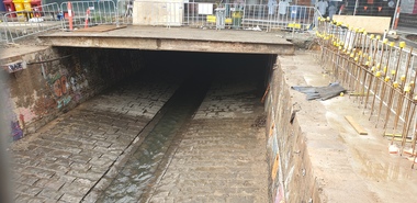
Photograph, Clare Gervasoni, Uncovered Bridge in Bridge Street, Ballarat, 2024, 01/12/2024
Photographs of the uncovered bridge that runs through Bridge Street, and through two covered shopping precincts.bridge street, bridge, ballarat -
 Bendigo Historical Society Inc.
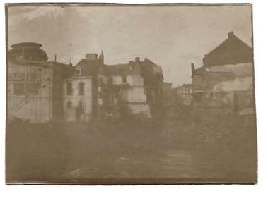
Photograph - ROBERT DENIS KELLY COLLECTION: MAUBEUGE BRIDGE MINED
Black and white photo: Maubeuge bridge, (indistinct). Written on back of photo 'Maubeuge bridge mined'.person, robert denis kelly, world war 1, france, bridge, manteuge -
 Port Melbourne Historical & Preservation Society
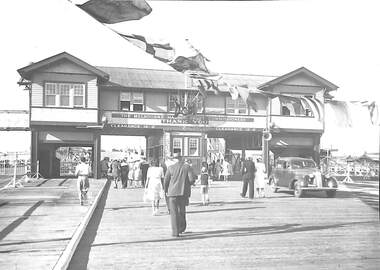
Photograph - Station Pier Gatehouse, c1946 - 47
(From Glen Stuart). Photos taken from Centenary Bridge c1947. HMS Glory (inner East). HMS Implacable (outer East). HMS Indefatigable (outer West). Unknown freighter at Inner West. Ships still in wartime grey and used to transport personnel and equipment back to Australia after the war, before returning to England. PMHPS assume that these five photos (3354.01 - .05) were taken on the same day. See Glen Stuart's comment above although this photo has been taken on the pier looking back through the gatehouse towards Centenary Bridge. HMS Glory, Implacable and Indefatigable with attendant destroyers Tuscan and Armada arrived in Port Melbourne on 23 January 1946 and returned to England in 1947. [This series of photos 3354.01 - .05 as well as 3361 and 3362 came to PMHPS from the Moe Historical Society via the St Kilda Historical Society. Notations in pencil on the back along the left had edge indicate they came from "C W Ward photo, 355 High St, Prahran, Melbourne". Each photo bears the date 9-12-1947 in the top left corner. It is not known what this date refers to. Possibly it is when the photo was printed. Another notation on each photo says "Port Melbourne, taken in 1920". This is definitely incorrect and "NOT" has been written underneath this comment.]Station Pier Gatehouse from waterside with bunting and a "Thank You" sign attached. Pedestrians walking towards Centenary Bridge. c1946 - 47C W Ward photo, 355 High St, Prahran, Melbournepiers and wharves - station pier, war - world war ii, centenary bridge -
 Melbourne Tram Museum
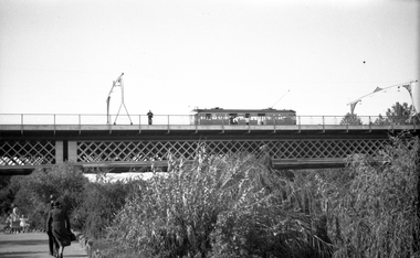
Negative, Wal Jack, c1941
... Bridges ...Black and white negative, by Wal Jack, of W2 392 (from information in the Wal Jack Album) crossing the Swan St or Wallen St bridge over the Yarra River. Photo not dated, in the Wal Jack album.trams, tramways, swan st, wallen road, bridges, w2 class, yarra river, tram 392 -
Glenelg Shire Council Cultural Collection
Photograph - Photograph -Bridge, n.d
Sourced from Casterton Town Hall (former Shire of Glenelg)Coloured photograph. Unmade road between paddocks. Photo taken close to bridge with wooden railings. Erosion of creek sides can be seen. Sign at bridge ' Bridge Load Limit 5 t gross'? Same bridge as 7301, taken at different time.