Showing 23522 items matching "early-20c"
-
 Marysville & District Historical Society
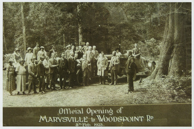
Photograph (Item) - Black and white photograph, Official Opening of MARYSVILLE to WOODSPOINT RD 5th Feb, 1923, 05-02-1924
An early black and white photograph which was taken after the ceremonial re-opening of the Marysville-Wood's Point Road in 1924. The date of 1923 on the photograph is incorrect.An early black and white photograph which was taken after the ceremonial re-opening of the Marysville-Wood's Point Road in 1924. The date of 1923 on the photograph is incorrect. The Marysville-Woods Point Road was originally part of the Yarra Track, constructed in the early 1860s to provide access between Healesville and the Woods Point Goldfields. Despite the steep terrain and engineering difficulties, the Yarra Track soon became a busy route used by pack horses, horse-drawn drays, and wagons. Today this sealed mountain road is a popular scenic drive between Marysville and Warburton.Official Opening of/ MARYSVILLE to WOODSPOINT RD/ 5th Feb, 1923marysville-wood's point road, marysville, wood's point goldfields, healesville, yarra track, warburton, the argus -
 Marysville & District Historical Society
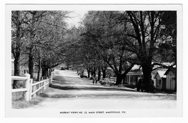
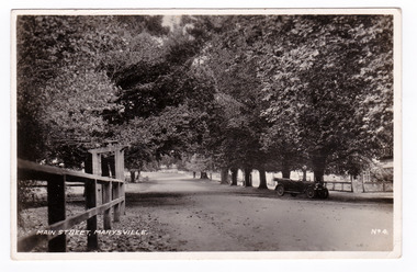
Postcard (item) - Black and white postcard, Murray Views, Murray Views No. 53. Main Street, Marysville, Vic, Post 1929
An early black and white photograph of the main street in Marysville in Victoria.An early black and white photograph of the main street in Marysville in Victoria. This street is now known as Murchison Street. This postcard was produced by Murray Views in Gympie, Queensland as a souvenir of Marysville.POST CARD STAMP REAL PHOTOGRAPH PRODUCED IN/ AUSTRALIA BY MURRAY VIEWS, GYMPIE, Q.murchison street, marysville, victoria, postcard, murray views, souvenir -
 Marysville & District Historical Society
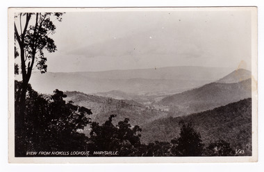
Postcard (item) - Black and white postcard, Valentine Publishing Co. Pty. Ltd, View From Nicholl's Lookout, Marysville. V. 43, 1923-1963
An early black and white photograph of the view of Marysville in Victoria taken from Nicholl's Lookout.An early black and white photograph of the view of Marysville in Victoria taken from Nicholl's Lookout. This lookout is situated on the Marysville-Wood's Point Road. The Marysville-Woods Point Road was originally part of the Yarra Track, constructed in the early 1860s to provide access between Healesville and the Woods Point Goldfields. Despite the steep terrain and engineering difficulties, the Yarra Track soon became a busy route used by pack horses, horse-drawn drays, and wagons. Today this sealed mountain road is a popular scenic drive between Marysville and Warburton. This postcard was published by the Valentine Publishing Co Pty. Ltd. as a souvenir of Marysville.VALENTINE'S/ POST CARD/ A GENUINE PHOTOGRAPHmarysville, nicholl's lookout, victoria, postcard, valentine publishing co, souvenir -
 Marysville & District Historical Society
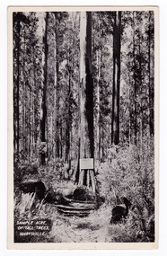
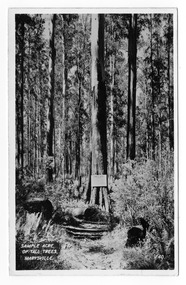
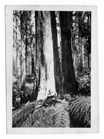
Postcard (item) - Black and white postcard, Valentine Publishing Co. Pty. Ltd, Sample Acre of Tall Trees, Marysville. V. 40, 1923-1963
An early black and white photograph of a sample acre of tall trees near Marysville in Victoria.An early black and white photograph of a sample acre of tall trees near Marysville in Victoria. After the devastating 1939 ‘Black Friday’ bushfires, Victoria’s tallest known trees were to be found in the Cumberland scenic reserve, 20 km north-east of Marysville. This stand of trees was set aside in the 1920s to preserve a ‘sample acre’ of tall trees. It originally contained 27 trees, the tallest of which was said to be 92 m, whilst the average height was 81 m. A severe wind storm in 1959 blew down 13 trees and left the ‘tall tree’ at a reduced 84 m (Munro 1992). An examination of the crown of this tree by arborist Tom Greenwood (Tom Greenwood pers. comm. 2001) suggested that it was unlikely that it ever reached the original figure of 92 m; the current height is 81.5 m, a figure used as the starting point for this search for Victoria’s tallest trees. This postcard was published by the Valentine Publishing Co. Pty. Ltd. as a souvenir of Marysville.VALENTINE'S/ POST CARD/ A GENUINE PHOTOGRAPHsample acre, tall trees, marysville, victoria, cumberland valley, postcard, valentine publishing co, souvenir, 1939 bushfires, cumberland scenic reserve -
 Marysville & District Historical Society
Postcard (item) - Black and white postcard, Valentine Publishing Co. Pty. Ltd, Sample Acre of Tall Trees, Marysville. V. 40, 1923-1963
An early black and white photograph of a sample acre of tall trees near Marysville in Victoria.An early black and white photograph of a sample acre of tall trees near Marysville in Victoria. After the devastating 1939 ‘Black Friday’ bushfires, Victoria’s tallest known trees were to be found in the Cumberland scenic reserve, 20 km north-east of Marysville. This stand of trees was set aside in the 1920s to preserve a ‘sample acre’ of tall trees. It originally contained 27 trees, the tallest of which was said to be 92 m, whilst the average height was 81 m. A severe wind storm in 1959 blew down 13 trees and left the ‘tall tree’ at a reduced 84 m (Munro 1992). An examination of the crown of this tree by arborist Tom Greenwood (Tom Greenwood pers. comm. 2001) suggested that it was unlikely that it ever reached the original figure of 92 m; the current height is 81.5 m, a figure used as the starting point for this search for Victoria’s tallest trees. This postcard was published by the Valentine Publishing Co. Pty. Ltd. as a souvenir of Marysville.VALENTINE'S POST CARD A GENUINE PHOTOGRAPHsample acre, tall trees, marysville, victoria, cumberland valley, postcard, valentine publishing co, souvenir, 1939 bushfires, cumberland scenic reserve -
 Federation University Historical Collection
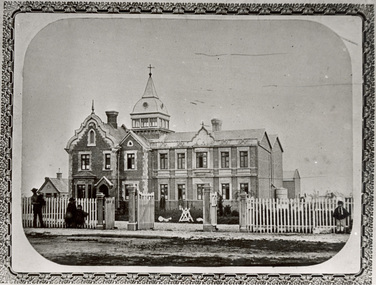
Photograph - Photograph - black and white, Benevolent Asylum Ballarat, 1861
The Ballarat Benevolent Asylum is an early Ballarat institution. The Building depicted was demolished and is now the site of the Queen Elizabeth centre. Black and white photograph of an early Ballarat building. It is the double storey building known as the Ballarat Benevolent Asylum (Later the Queen Elizabeth Centre) ballarat, benevolent asylum, asylum, ballarat benevolent asylum, queen elizabeth benevolent asylum, welfare, queen elizabeth home -
 Surrey Hills Historical Society Collection
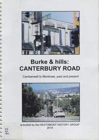
Book, Burke & hills: Canterbury Road, Camberwell to Montrose, past and present, 2014
Co-author Gerry Robinson was a speaker at a Surrey Hills Historical Society (SHHS) meeting. Lyndel Walker, member of SHHS, purchased the book for the collection. This book examines the changing landscape of Canterbury Road from the early days of settlement until today (2015)This book examines the changing landscape of Canterbury Road from the early days of settlement until today (2015)burke, surrey hills, canterbury, broughton park, vegetation, (mr) denis delaney, geology, (mr) john mcclare, geography, (mrs) mary mcclare, churches -
 Marysville & District Historical Society
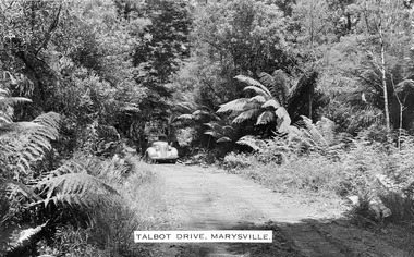
Photograph (item) - Black and white photograph, Talbot Drive, Marysville, Unknown
An early black and white photograph of Lady Talbot Drive in Marysville in Victoria.An early black and white photograph of a car traveling along Lady Talbot Drive in Marysville in Victoria. Lady Talbot Drive a 24 kilometer scenic rainforest car journey which passes a number of walks and waterfalls in the Yarra Ranges National Park. Lady Talbot Drive is named after Lady Sarah Elizabeth, the wife of Sir Reginald Talbot, who was the Governor of Victoria from 25th April, 1904 to 6th July 1908. This road was originally constructed as a corduroy road (or log road) is a type of road or timber trackway made by placing logs, perpendicular to the direction of the road over a low or swampy area. The result is an improvement over impassable mud or dirt roads, yet rough in the best of conditions and a hazard to horses due to shifting loose logs.marysville, victoria, lady talbot drive, lady talbot forest drive, sir reginald talbot, lady sarah elizabeth talbot, corduroy road -
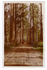 Marysville & District Historical Society
Photograph (item) - Colour tinted photograph, Valentine Publishing Co. Pty. Ltd, On the Acheron Way to Marysville . No.12, 1923-1963
An early colour tinted photograph of the Acheron Way near Marysville in Victoria. This photograph was published by the Valentine Publishing Co Pty. Ltd as a souvenir of Marysville.An early colour tinted photograph of the Acheron Way near Marysville in Victoria. The Acheron Way is an unsealed, winding road that runs from just outside of Marysville to Warburton. This photograph was published by the Valentine Publishing Co Pty. Ltd as a souvenir of Marysville.acheron way, marysville, victoria, valentine publishing co, souvenir, warburton -
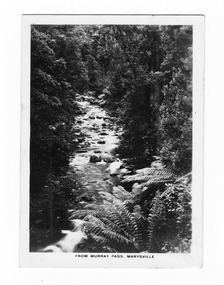 Marysville & District Historical Society
Photograph (item) - Black and white photograph, Rose Stereograph Company, From Murray Pass, Marysville, 1913-1967
An early black and white photograph of the Taggerty River from Murray Pass near Marysville, Victoria.An early black and white photograph of the Taggerty River from Murray Pass near Marysville, Victoria. Murray Pass is off the Lady Talbot Drive. Lady Talbot Drive a 24 kilometer scenic rainforest car journey which passes a number of walks and waterfalls in the Yarra Ranges National Park. Lady Talbot Drive is named after Lady Sarah Elizabeth, the wife of Sir Reginald Talbot, who was the Governor of Victoria from 25th April, 1904 to 6th July 1908.The photograph was also used to produce the Rose Series postcard P. 2309.marysville, victoria, photograph, taggerty river, murray pass, lady talbot forest drive, p. 2309, rose series postcard, souvenir, rose stereograph company, sir reginald talbot, lady sarah elizabeth talbot -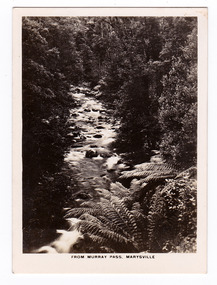
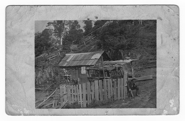 Marysville & District Historical Society
Postcard (item) - Black and white postcard, Unknown
An early black and white photograph taken at the Golden Bower Mine Camp in the Cumberland Valley in Victoria.An early black and white photograph taken at the Golden Bower Mine Camp in the Cumberland Valley in Victoria. The Golden Bower gold mine was a quartz reef mine. William Edward Chester discovered the Golden Secret gold vein which became part of the Golden Bower Mine at Chesterville near Donovans Creek on the Cumberland goldfield which he mined with George Locke until the late 1930s. POST CARD CORRESPONDENCE. ADDRESS ONLY. KODAK/ AUSTRALIA 30/06/10 Rose Hill/ Fitzwilliam Street/ Kew Should have written/ to you months ago about the/ photos I took at Easter./ Sorry to say the one of the little/ girls was no good I expect/ you will recognise both these/ places/ K McDowell Mrs Fletcher/ Golden Bower Mine/ Via Marysville J Mahoneygolden bower gold mine, cumberland valley, victoria, quartz reef mining, water-powered battery, william edward chester, george locke, chesterville, donovan's creek, cumberland goldfield -
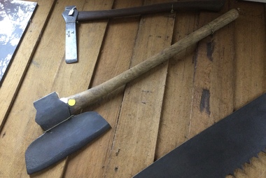 Mont De Lancey
Tool - Broad Axe, Unknown
Used in the 19th or early 20th century.A steel forged metal headed broad axe with a turned wooden handle for a right handed person's use. It was used to trim posts or logs in the 19th or early 20th century.axes, cutting tools, hand axes, froes, woodworking tools, cleaving tools -
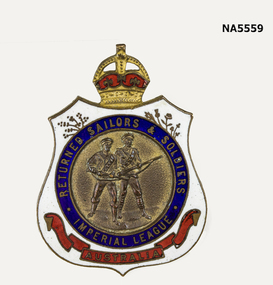 Whitehorse Historical Society Inc.
Accessory - R.S.L. badge
Early R. S. L. badge Early R.S.L. badge - 2 figures -army & navy. White background with blue circle & red on bottom, crown on top. "Returned Sailors & Soldiers" No. 87261 F. TestroAustraliar.s.l., badge, army & navy -
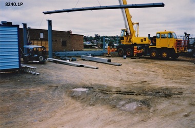 Bendigo Military Museum
Photograph - SERVICEMAN'S CLUB, C.1993
These photos show the early renovations to the Bendigo District Servicemen’s Club in 1993 Havilah Road. Refer Cat No's 8073P, 8171 & 8230.2 for more history..1) - .6) Series of 6 photographs colour showing early stages to the renovations of the Bendigo District Servicemen’s Club in Havilah Road.brsl, smirsl, bdsc, renovations -
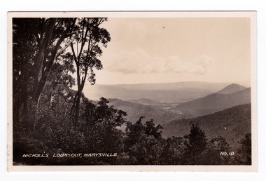 Marysville & District Historical Society
Photograph (item) - Black and white photograph, Valentine Publishing Co. Pty. Ltd, Nicoll's Lookout, Marysville No.10, 1923-1963
An early black and white photograph of Nicholl's Look-out near Marysville in Victoria.An early black and white photograph of Nicholl's Look-out near Marysville in Victoria. This lookout is situated on the Marysville-Wood's Point Road. The Marysville-Woods Point Road was originally part of the Yarra Track, constructed in the early 1860s to provide access between Healesville and the Woods Point Goldfields. Despite the steep terrain and engineering difficulties, the Yarra Track soon became a busy route used by pack horses, horse-drawn drays, and wagons. Today this sealed mountain road is a popular scenic drive between Marysville and Warburton. This photograph was published by the Valentine Publishing Co Pty. Ltd. as a souvenir of Marysville.marysville, victoria, valentine publishing co, souvenir, nicholl's look-out, mining, yarra track -
 Marysville & District Historical Society
Photograph (item) - Black and white photograph, 10-1947
An early black and white photograph taken in the Cumberland Valley near Marysville in Victoria.An early black and white photograph taken in the Cumberland Valley near Marysville in Victoria. The Cumberland Valley is near Cambarville which was a timber town near Marysville. Cambarville is notable for its giant mountain ash (Eucalyptus regnans) trees within the Cumberland Memorial Scenic Reserve, and relics from former sawmills and gold mining. The Big Culvert is located nearby on the Marysville - Woods Point Road, which was historically part of the Yarra Track. Cambarville was established as a timber mill town in the 1940s. Timber mill owners A Cameron and FJ Barton named Cambarville. They established the mill to salvage timber from trees destroyed in the 1939 bushfires. Cambarville was impacted by the 2009 Black Saturday bushfires and any remaining structures were destroyed.Among Tall Timber at/ Cumberland Valley. Oct.47. 39cumberland valley, marysville, victoria, cumberland creek, mountain ash, timber mill, mining, a cameron, fj barton, cambarville, big culvert, yarra track, black saturday bushfires, 1939 bushfires, photograph -
 Bendigo Military Museum
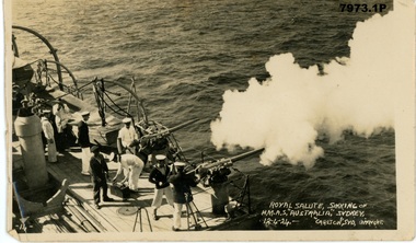
Photograph - ARTHUR GEORGE HOLLEY PHOTOGRAPHIC ALBUM 24 PHOTOGRAPHS, HMAS Sydney 1925-1927 and HMAS Australia 1930-1931
Items in the collection relating to ARTHUR GEORGE HOLLEY no 13556 RAN Refer cat no 2134 for his service record. The photographs are from his personal album, and are mainly official photographs widely available among the services. The photographs are from Australian , British and American sources. This set illustrates Holley's service on HMAS Sydney in the mid 1920s and HMAS Australia in the early 1930s They are a mixture of official and personal photographs and capture the events he and his HMAS Australia crewmates would have experienced and witnessed. Photographs taken around the time of Holley's service on HMAS Australia in the early 1930sinterwar period, arthur george holley, hmas australia, hmas sydney -
 Camperdown & District Historical Society
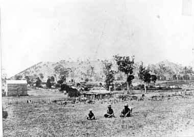
Photograph - Aboriginal people at Mt Leura, Camperdown, c1875
Three Djargurd Wurrung people on Country, pictured in front of Mt Leura, Camperdown c1875. This image also shows early primitive dwellings, Ower's flour mill (built 1868) and surviving native vegetation. Image of three Djargurd Wurrung people seated in front of Mt Leura, Camperdown, taken near corner of Scott and Curdie Streets c1875. On back: Early 1870s, Bought at first land sale Cr Scott & Curdie St, F.H. Grant, 11 Adeney Streetcdhs, djargurdwurrung, wombeetch puyuun, camperdown george, prince charlie, mount leura, mount sugarloaf, mt sugarloaf, ower's mill, cdhsfirstnations -
 Whitehorse Historical Society Inc.
Article, The Secrets of Hardwood King, 1980's
Algernon John Elmore (1882 - 1961) .Algernon John Elmore (1882 - 1961) or 'The Hardwood King' designed and built more than 50 craftsman bungalows in Blackburn in the early 1900's.Algernon John Elmore (1882 - 1961) .elmore, algernon, john, elmore houses -
 Marysville & District Historical Society
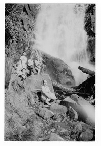
Photograph (item) - Black and white photograph, January 1950
An early black and white photograph of Steavenson Falls in Marysville in Victoria.An early black and white photograph of a group of people sitting at the base of Steavenson Falls in Marysville in Victoria. The Steavenson Falls is named after the Victoria Assistant Commissioner of Roads and Bridges, John Steavenson who arrived in Victoria in the early 1860's.Family Group Steavenson Falls Jan. 1950 From: Judith Macdonald Professional/ Color Papersteavenson falls, marysville, victoria, waterfalls, photograph, john steavenson -
 Marysville & District Historical Society
Postcard (item) - Black and white postcard, Valentine Publishing Co. Pty. Ltd, Main Street, Marysville. No.4, 1923-1963
An early black and white photograph of the main street in Marysville in Victoria. An early black and white photograph of the main street in Marysville in Victoria. That street is now known as Murchison Street. This postcard was published by the Valentine Publishing Co. Pty. Ltd. as a souvenir of Marysville.VALENTINE'S/ POST CARD/ FOR CORRESPONDENCE/ FOR ADDRESS ONLY PRINTED IN GREAT BRITAIN The Valentine Publishing Co. Pty. Ltd., Melbourne. Dear Joan Just a card to wish all/ you girls a Merry Xmas/ I hope you all have a good time/ & suppose the Matron will/ throw a Big party/ Yours A Burgess.marysville, victoria, murchison street, postcard, souvenir, valentine publishing co -
 Marysville & District Historical Society
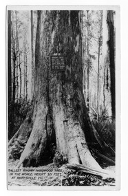
Postcard (item) - Black and white postcard, Valentine Publishing Co. Pty. Ltd, Tallest Known Hardwood Tree in the World, Height 301 Feet at Marysville, Vic. V10, 1923-1963
An early black and white photograph of the Big Tree in Cambarville in Victoria.An early black and white photograph of the Big Tree in Cambarville in Victoria. It was, at one stage, known to be the tallest hardwood tree in the world standing at 92 meters (301ft, 6 inches). However, it was reduced to 84 meters by a wind storm in 1959. It is a mountain ash. There is a walking track through the forest that will take you to the Big Tree. This postcard was published by Valentine Publishing Co. Pty. Ltd. as a souvenir of Marysville.VALENTINE'S/ POST/ CARD A GENUINE PHOTOGRAPH Dear Mother & Dad I received your letter and/ was glad to know everything is OK at home./ The weather is still pretty good. Today is dull/ with a drop of rain every now & then but not enough/ to stop you from going out. Tomorrow we are going/ to the Eildon Weir so we are hoping it stays fine./ Had a letter from Mrs Thompson. She says Alison is/ doing fine. She has been playing with Judy/ You didnt way whether you were coming up here or/ not but I doubt whether you will get in after next/ week as it is the school holidays. Cumberland House/ seems to be very nice + it is on the main road let me/ know by return post & Ill see what I can do for you./ I think the tariff seems to be the same. Well dear thats all for/ now as I want to send a card to Auntie Love Ethel & Clarriebig tree, mountain ash, cambarville, victoria, valentine publishing co, postcard, souvenir -
Whitehorse Historical Society Inc.
Article, Orchard as museum piece is proposed, 1969
Council is considering a request from Nunawading Historical Society to find accommodation for an old wagon and a plough.Council is considering a request from Nunawading Historical Society to find accommodation for an old wagon and a plough. A municipal orchard maintained as a link with Nunawading's early history was suggested.Council is considering a request from Nunawading Historical Society to find accommodation for an old wagon and a plough.orchards, city of nunawading, nunawading historical society -
 Marysville & District Historical Society
Photograph (Item) - Black and white photograph, Fernshaw, c1900
An early black and white photograph taken at Fernshaw.An early black and white photograph taken at Fernshaw. Fernshaw was a rural township 63 km north-east of Melbourne and 10 km north-east of Healesville. Situated on the Watts River, near where a log had fallen making a convenient crossing, Fernshaw was settled in the 1860s. It provided good country for orchards and berry growing. The location was at the foot of Blacks Spur, with Mounts Juliet and Mondah rising on either side, providing spectacular scenery. There were nearby fern gullies giving rise to the name – ‘shaw’ is old English for thicket or wood. By 1875 Fernshaw had a post office (1865), two hotels, a school (1871) and stores. It was famed for its beauty, attracting tourists. In 1886 the Melbourne and Metropolitan Board of Works began work on the Watts River water catchment scheme – later to become Maroondah – and the Board obtained approval for the catchment country to be reserved and kept free of settlement. This required the removal of the Fernshaw township, which was completed by about 1890. The area was described in the 1903 Australian handbook:ARMSTRONG COLLECTION 42 STATION STREET/ SANDRINGHAM 3191/ TEL. (03) 9521 5442/ IAN M.L. ARMSTRONG OAMfernshaw, healesville, watts river, orchard, berry orchard, blacks spur, black spur, mount juliet, mount mondah, maroondah dam, victoria -
 Bendigo Historical Society Inc.
Photograph - B&W photograph of a "float" for the Myer Store for the Bendigo Easter Fair
Early 1900s streetscape of major intersection in BendigoLandscape format. B&W photograph of a "float" for the Myer Store entered in the Bendigo Easter Fair, undated early 1900s photograph. Four people representing Myer on the floatsocial history -
 Mont De Lancey
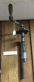
Tool - Combination Clamp and Drill, O.W. Burritt and Bro
Used in the late 19th or early 20th CenturyA two piece steel Burritt Combination Clamp and Drill (clamp is missing) with a wooden handle at the top that turns to operate the mechanism. It was used in the late 19th or early 20th Century.1901 - 1908 Brand: O.W. Burritt & Bro Weedsport, NY, USAdrills, push drills, hand drills, tools, hand tools, clamps, handscrew clamps -
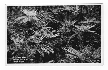 Marysville & District Historical Society
Postcard (item) - Black and white postcard, Valentine Publishing Co. Pty. Ltd, Beautiful Ferns, on Michaeldene Track, Marysville. V.25, 1923-1963
An early black and white photograph of tree ferns along the Michaeldene Track in Marysville in Victoria.An early black and white photograph of tree ferns along the Michaeldene Track in Marysville in Victoria. This walking track links the Steavenson River and the Taggerty Rivers and is a step back in time to Marysville's historic logging past. Sections of this mostly flat circuit follow old tramline alignments, which in places reveal the original timber sleepers on which the big logs were transported to the nearby sawmill. This postcard was produced by the Valentine Publishing Co as a souvenir of Marysville.VALENTINE'S POST CARD A GENUINE PHOTOGRAPHmichaeldene track, walking track, marysville, victoria, tree fern, steavenson river, taggerty river, logging -
 Marysville & District Historical Society
Photograph (item) - Black and white photograph, Unknown
A digital copy of an early black and white photograph of Keppel Falls near Marysville in Victoria.A digital copy of an early black and white photograph of Keppel Falls near Marysville in Victoria. The Keppel Falls are named after the Keppel Family who were among Marysville's earliest pioneering families. The log was placed across the falls to be used as a bridge.keppel falls, marysville, victoria, photograph, waterfalls, keppel family -
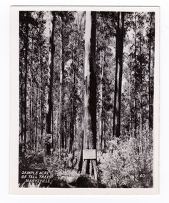 Marysville & District Historical Society
Photograph (item) - Black and white photograph, Valentine Publishing Co. Pty. Ltd, Sample Acre of Tall Trees, Marysville. V. 40, 1923-1963
An early black and white photograph of a sample acre of tall trees near Marysville in Victoria.An early black and white photograph of a sample acre of tall trees near Marysville in Victoria. After the devastating 1939 ‘Black Friday’ bushfires, Victoria’s tallest known trees were to be found in the Cumberland scenic reserve, 20 km north-east of Marysville. This stand of trees was set aside in the 1920s to preserve a ‘sample acre’ of tall trees. It originally contained 27 trees, the tallest of which was said to be 92 m, whilst the average height was 81 m. A severe wind storm in 1959 blew down 13 trees and left the ‘tall tree’ at a reduced 84 m (Munro 1992). An examination of the crown of this tree by arborist Tom Greenwood (Tom Greenwood pers. comm. 2001) suggested that it was unlikely that it ever reached the original figure of 92 m; the current height is 81.5 m, a figure used as the starting point for this search for Victoria’s tallest trees. This photograph was published by the Valentine Publishing Co. Pty. Ltd. as a souvenir of Marysville.sample acre, tall trees, marysville, victoria, cumberland valley, valentine publishing co, photograph, souvenir, 1939 bushfires, cumberland scenic reserve