Showing 5706 items
matching eltham road district
-
 Eltham District Historical Society Inc
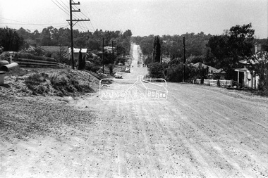
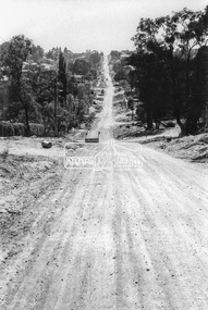
Photograph, Looking east along Pitt Street, Eltham, c. September 1966, Stebbing Cottage on right, 1966c
Stebbing cottage on rightBlack and white photographic printOriginally located in a Filmpro King Size Prints processing envelope $3.01 Shire of Eltham 9/9/66 and noted as Calrossie Ave area and crossed out Eltham-Yarra Glen Road, Bridge Street to Elsa Court existing conditions mid 1967pitt street, road construction, stebbing cottage, streets -
 Eltham District Historical Society Inc
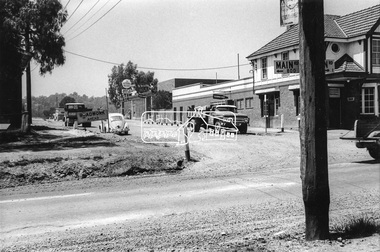
Photograph, Eltham Hotel, corner of Pitt Street and Main Road, c. September 1966, 1966c
Black and white photographic printOriginally located in a Filmpro King Size Prints processing envelope $3.01 Shire of Eltham 9/9/66 and noted as Calrossie Ave area and crossed out Eltham-Yarra Glen Road, Bridge Street to Elsa Court existing conditions mid 1967eltham hotel, main road, pitt street, road construction, streets -
 Eltham District Historical Society Inc
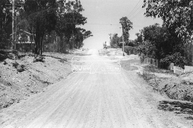
Photograph, Looking west along Brougham Street near No. 101, Eltham, c. September 1966, 1966c
Black and white photographic printOriginally located in a Filmpro King Size Prints processing envelope $3.01 Shire of Eltham 9/9/66 and noted as Calrossie Ave area and crossed out Eltham-Yarra Glen Road, Bridge Street to Elsa Court existing conditions mid 1967brougham steet, road construction, streets -
 Eltham District Historical Society Inc
Photograph, Looking south along Bible Street towards Brougham Street, c. September 1966, 1966c
Black and white photographic printOriginally located in a Filmpro King Size Prints processing envelope $3.01 Shire of Eltham 9/9/66 and noted as Calrossie Ave area and crossed out Eltham-Yarra Glen Road, Bridge Street to Elsa Court existing conditions mid 1967bible street, brougham steet, road construction, streets -
 Eltham District Historical Society Inc
Photograph, Looking north along Bible Street, Eltham near No. 11, c. September 1966, 1966c
Black and white photographic printOriginally located in a Filmpro King Size Prints processing envelope $3.01 Shire of Eltham 9/9/66 and noted as Calrossie Ave area and crossed out Eltham-Yarra Glen Road, Bridge Street to Elsa Court existing conditions mid 1967bible street, road construction, streets -
 Eltham District Historical Society Inc
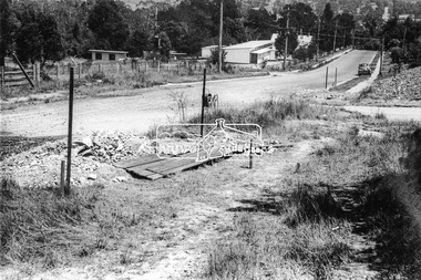
Photograph, Looking west at intersection of Dalton and Bible streets, Eltham, c. September 1966, 1966c
Black and white photographic printOriginally located in a Filmpro King Size Prints processing envelope $3.01 Shire of Eltham 9/9/66 and noted as Calrossie Ave area and crossed out Eltham-Yarra Glen Road, Bridge Street to Elsa Court existing conditions mid 1967bible street, dalton street, road construction, streets -
 Eltham District Historical Society Inc
Photograph, W 27, Mitchell Avenue (Reserve next to Montmorency South Primary), 1966c
Grand Boulevard on right. Looking at what is now Panorama Heights preschoolBlack and white photographic printOriginally located in a Filmpro King Size Prints processing envelope $3.01 Shire of Eltham 9/9/66 and noted as Calrossie Ave area and crossed out Eltham-Yarra Glen Road, Bridge Street to Elsa Court existing conditions mid 1967grand boulevard, mitchell avenue, montmorency, panorama heights pre-school -
 Eltham District Historical Society Inc
Photograph, Plenty River at end of Palara Court, Montmorency, c.September 1966, 1966c
Black and white photographic printOriginally located in a Filmpro King Size Prints processing envelope $3.01 Shire of Eltham 9/9/66 and noted as Calrossie Ave area and crossed out Eltham-Yarra Glen Road, Bridge Street to Elsa Court existing conditions mid 1967montmorency, palara court, plenty river -
 Eltham District Historical Society Inc
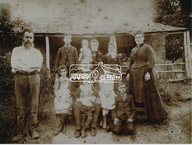
Photograph, Rodda family at Chun Grove, c.1891, 1891c
Rodda family except two boys, Arthur and Fred. Back Row L-R: Herbert Rodda, baby Walter held by Mary Jane (nee May), cousin Annie Walker Front Row L-R: Father "Joseph", Ettie, Grandpa Rodda Nicholas holding Eva, Minnie and Edwin, and Mother-in-law Esther Chun Grove was located on Main Road opposite the present BP service station at cnr of Beard StreetDigital file only - Color photo reprint (15 x 20 cm) and A4 photocopy of reverse on loan for scanning by EDHSannie walker, chun grove, edwin rodda, eltham, esther may, ettie rodda, eva rodda, grandpa rodda, herbert rodda, joseph rodda, mary jane rodda (nee may), minnie rodda, nicholas rodda, rodda, walter rodda -
 Eltham District Historical Society Inc
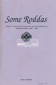
Book, Gwen Rodda, Some Roddas: Being a record of the ancestors and descendents of Nicholas Rodda, 1805-1896, 1992
The Rodda family home, Chun Grove, was located on Main Road, Eltham opposite the present BP service station at the corner of Beard Street.Digital file only (74) - Cover and pages 64-136 and explanatory letter of self published book (1992) on loan for scanning by EDHSchun grove, eltham, family history, gwen rodda, nicholas rodda, research (vic.), rodda -
 Eltham District Historical Society Inc
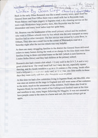
Document, Rodda recollections by Joan Gay
Joan Gay (nee Ramsdale) was the daughter of Charles and Vera Ramsdale who owned the Research General Store.Digital file only - A4 photocopy of page on loan for scanning by EDHSbranton, brinkotter poultry farm, bus services, charles ramsdale, collingwood football club, ingrams road, ivy reynolds, joan gay (nee ramsdale), jupps piggery, linden strike drive, lyon bros, milk bar, mrs hill, neil mann, research (vic.), research cricket club, research hall, research primary school, research tennis club, reynolds road, rodda, tram, vera ramsdale, wests bakery, reminscences -
 Eltham District Historical Society Inc
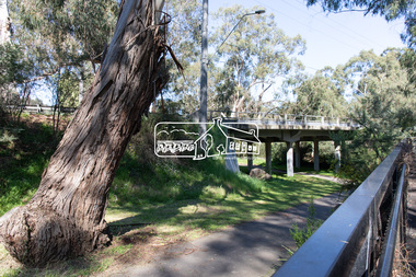
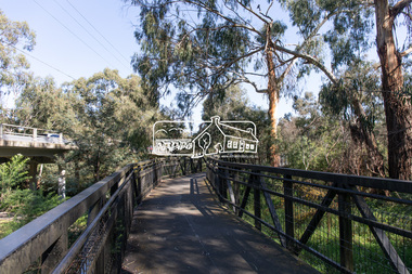
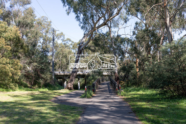
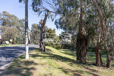
Photograph, Peter Pidgeon, Manna Gum, Main Road Bridge, Eltham South, 8 Sep. 2021
This significant tree located near the Main Road Bridge and Diamond Creek Trail footbridge over the Diamond Creek at Eltham dates back to the early 1900s. The original timber bridge over the Diamond Creek was built around 1840. It was destroyed by floodwaters in October 1923. A temporary bridge was rigged up but further damaged in April 1924. A new concrete bridge was built and opened in October 1926. The bridge decking was widened along with Main Road to Dalton Street by the Road Construction Authority in 1984., The uygraded bridge was opened in October 1984, 78 years after its original opening.These trees are not only significant for the natural environment but also present a navigational beacon back in time as the environmental landscape is developed around them.Born Digitaleltham south, main road bridge, manna gum, significant tree, diamond creek trail -
 Eltham District Historical Society Inc
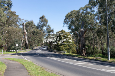
Photograph, Peter Pidgeon, Manna Gums, Main Road Bridge, Eltham South, 8 Sep. 2021
The original timber bridge over the Diamond Creek was built around 1840. It was destroyed by floodwaters in October 1923. A temporary bridge was rigged up but further damaged in April 1924. A new concrete bridge was built and opened in October 1926. The bridge decking was widened along with Main Road to Dalton Street by the Road Construction Authority in 1984., The uygraded bridge was opened in October 1984, 78 years after its original opening.These trees are not only significant for the natural environment but also present a navigational beacon back in time as the environmental landscape is developed around them.Born Digitaleltham south, main road bridge, manna gum, diamond creek trail -
 Eltham District Historical Society Inc
Photograph, Peter Pidgeon, Manna Gum, Main Road Bridge, Eltham South, 8 Sep. 2021
This significant tree located near the Main Road Bridge and Diamond Creek Trail footbridge over the Diamond Creek at Eltham dates back to the early 1900s. The original timber bridge over the Diamond Creek was built around 1840. It was destroyed by floodwaters in October 1923. A temporary bridge was rigged up but further damaged in April 1924. A new concrete bridge was built and opened in October 1926. The bridge decking was widened along with Main Road to Dalton Street by the Road Construction Authority in 1984., The uygraded bridge was opened in October 1984, 78 years after its original opening.These trees are not only significant for the natural environment but also present a navigational beacon back in time as the environmental landscape is developed around them.Born Digitaleltham south, main road bridge, manna gum, significant tree, diamond creek trail -
 Eltham District Historical Society Inc
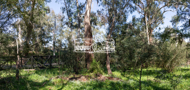
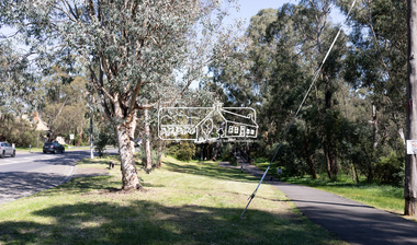
Photograph, Peter Pidgeon, Manna Gum, Main Road Bridge, Eltham South, 8 Sep. 2021
This significant tree located near the Main Road Bridge and Diamond Creek Trail footbridge over the Diamond Creek at Eltham dates back to around 1870-1880. The original timber bridge over the Diamond Creek was built around 1840. It was destroyed by floodwaters in October 1923. A temporary bridge was rigged up but further damaged in April 1924. A new concrete bridge was built and opened in October 1926. The bridge decking was widened along with Main Road to Dalton Street by the Road Construction Authority in 1984., The uygraded bridge was opened in October 1984, 78 years after its original opening.These trees are not only significant for the natural environment but also present a navigational beacon back in time as the environmental landscape is developed around them.Born Digitaleltham south, main road bridge, manna gum, significant tree, diamond creek trail -
 Eltham District Historical Society Inc
Photograph, Peter Pidgeon, Manna Gum, Main Road Bridge, Eltham South, 8 Sep. 2021
This significant tree located near the Main Road Bridge and Diamond Creek Trail footbridge over the Diamond Creek at Eltham dates back to around 1870-1880. The original timber bridge over the Diamond Creek was built around 1840. It was destroyed by floodwaters in October 1923. A temporary bridge was rigged up but further damaged in April 1924. A new concrete bridge was built and opened in October 1926. The bridge decking was widened along with Main Road to Dalton Street by the Road Construction Authority in 1984., The upgraded bridge was opened in October 1984, 78 years after its original opening.These trees are not only significant for the natural environment but also present a navigational beacon back in time as the environmental landscape is developed around them.Born Digitaleltham south, main road bridge, manna gum, significant tree, diamond creek trail -
 Eltham District Historical Society Inc
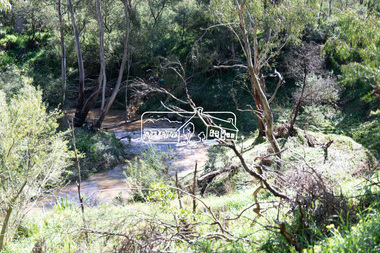
Photograph, Peter Pidgeon, Diamond Creek near Main Road Bridge, Eltham South, 8 Sep. 2021
Evidence of flooding from recent winter and early spring rainBorn Digitaleltham south, diamond creek trail, diamond creek (creek), floods -
 Eltham District Historical Society Inc
Photograph, Peter Pidgeon, Diamond Creek near Main Road Bridge, Eltham South, 8 Sep. 2021
Evidence of flooding from recent winter and early spring rainBorn Digitaleltham south, diamond creek trail, diamond creek (creek), floods -
 Eltham District Historical Society Inc
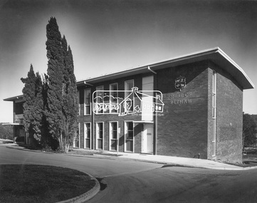
Photograph, Hugh Fisher, Eltham - Shire Office, 1968
Completion of stage one of the new Eltham Shire Office located at 895 Main Road Eltham. They were demolished in August 1996. Note the historic Shillinglaw trees at the front of the building.This photo forms part of a collection of photographs gathered by the Shire of Eltham for their centenary project book, "Pioneers and Painters: 100 years of the Shire of Eltham" by Alan Marshall (1971). The collection of over 500 images is held in partnership between Eltham District Historical Society and Yarra Plenty Regional Library (Eltham Library) and is now formally known as 'The Shire of Eltham Pioneers Photograph Collection.' It is significant in being the first community sourced collection representing the places and people of the Shire's first one hundred years.Digital image Print 20 x 24.5 cm (Eltham Library)Hugh Fisher Photographer , 82 Lygon St., Brunswick and 6 York St., Eltham. 439-9046 Image A1217sepp, shire of eltham pioneers photograph collection, eltham, eltham shire office, muncipal buildings -
 Eltham District Historical Society Inc
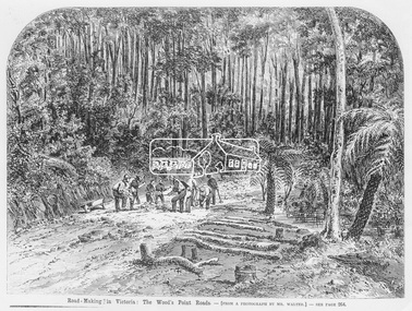
Photograph, Illustrated Melbourne Post, Road-making in Victoria. The Wood's Point Roads, 1866
Reproduced from "Illustrated Melbourne Post" 18 April 1866This photo forms part of a collection of photographs gathered by the Shire of Eltham for their centenary project book,"Pioneers and Painters: 100 years of the Shire of Eltham" by Alan Marshall (1971). The collection of over 500 images is held in partnership between Eltham District Historical Society and Yarra Plenty Regional Library (Eltham Library) and is now formally known as the 'The Shire of Eltham Pioneers Photograph Collection.' It is significant in being the first community sourced collection representing the places and people of the Shire's first one hundred years.Digital image Print 16.5 x 22 cm (Held at Eltham Library)sepp, shire of eltham pioneers photograph collection, other areas, road construction, woods point -
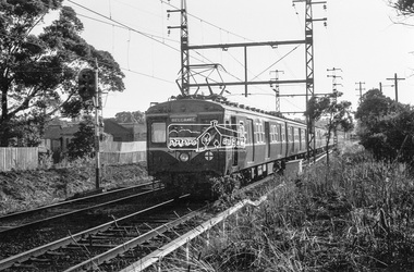
 Eltham District Historical Society Inc
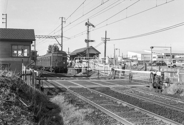
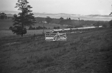
Photograph, George Coop, Tait (Red Rattler) train bound for Mordialloc at McKinnon Railway Station, c.Feb. 1964
Tait (Red Rattler) train bound for Mordialloc at McKinnon Road level crossing, McKinnon Railway Station, Frankston line, c. Feb. 1964 The level crossing is the old McKinnon Rd. level crossing right at Mckinnon Railway Station on the Melbourne-Franston line. It no longer exists as the level crossing was amongst the first to be removed in the State Govt. grade separation programme c 2015. The line now runs under Mckinnon Rd in a cutting that holds the new station as well. The folding metal lattice gates were the only ones of their kind in Victoria and fairly rare anywhere else in Australia as well.Digital TIFF file Scan of 35mm Ilford FP3 black and white transparencyfrankston line, george coop collection, level crossing, mckinnon railway station, mckinnon road, mordialloc, red rattler, tait train -
 Eltham District Historical Society Inc
Photograph, George Coop, Harris (Blue) electric train approaching Mont Albert Railway Station, c.Feb. 1964
Climbing the hill from Surrey Hills having just crossed Mont Albert Road.Digital TIFF file Scan of 35mm Ilford FP3 black and white transparencygeorge coop collection, harris (blue) train, mont albert railway station -
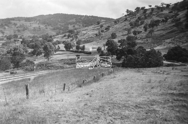 Eltham District Historical Society Inc
Photograph, George Burton Coop, Steam locomotive K-157 at Trawool Gap on the Tallarook-Mansfield-Alexandria branch line, c.1949
This is a road and rail connection to Yea, Mansfield and Alexandra from Tallarook, Vic. The railway was converted many years ago into a long and spectacular rail trail. Photograph by George Burton Coop (George Coop's father).Digital TIFF file Scan of Kopdak 620 black and white negative transparencygeorge coop collection, k-157, k-class steam locomotive (vr newport workshops), trawool gap -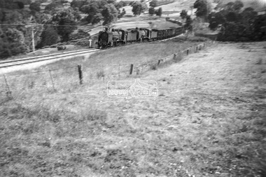
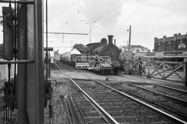 Eltham District Historical Society Inc
Photograph, George Coop, Steam locomotive Y-103 at Newport Railway Station, c.1951
The Melbourne Road level crossing is now the location of the pedestrian underpass. Hall Street is seen to the right and the two-storey brick building remains to present day. One of several photos at Newport taken the same day in the early 1950s when George Coop was a secondary school student.Digital TIFF file Scan of Kopdak 620 black and white negative transparencygeorge coop collection, hall street, level crossing, melbourne road, newport railway station, y-103, y-class steam locomotive -
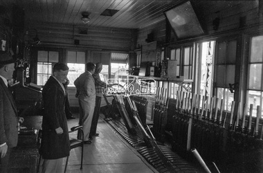 Eltham District Historical Society Inc
Photograph, George Coop, Newport Signal Box, Newport Railway Station, c.1951
Now demolished. Newport Railway station, visible through the windows was situated on the opposite side of the Melbourne Road level crossing. All of this infrastructure has since been replaced by a large overpass, the level crossing now the location of a pedestrain underpass. One of several photos at Newport taken the same day in the early 1950s when George Coop was a secondary school student.Digital TIFF file Scan of Kopdak 620 black and white negative transparencygeorge coop collection, newport railway station, level crossing, melbourne road, newport signal box -
 Eltham District Historical Society Inc
Photograph, George Burton Coop, The Royal Train enroute to Lilydale, near Croydon, 6 Mar. 1954
Believed to have been taken bewteen Croydon Railway Station and the Dorset Road bridge. Taken late afternnon by George Coop's father. There is a Landrover parked on the grass with a person standing on it - believed to be Security. George recalls originally being located closer to the fence and being ushered up the hill where it was 'safer' to stand. In 1954 at age 27, Queen Elizabeth II was the first reigning British monarch to visit Australia.. She visited Victoria between March 1-10. Where to see the Queen (1954, January 21). Fern Tree Gully and District Times (Boronia, Vic. : 1953-1954), p. 5. Retrieved October 25, 2021, from http://nla.gov.au/nla.news-article264220429 “The Lilydale Shire President, Cr. Burgi, stated that the Royal train en route for Warburton on Saturday, March 6th, would slow down at Croydon and Lilydale. There was little possibility that it would stop at either of these towns. The train would pass through Lilydale at 5.52 p.m. Council had appointed a sub-committee to arrange matters, and had allocated £400 towards expenses. It was suggested that the train slow down between the railway station and Dorset Rd. bridge at Croydon, and between the Cave Hill Quarry and railway station at Lilydale.” An album of images of the Queen's visit to Victoria is available on the PROV Flickr account at https://www.flickr.com/photos/public-record-office-victoria/7252885616Digital TIFF file Scan of Kopdak 620 black and white negative transparencygeorge coop collection, croydon, royal train