Showing 1531 items matching "high street road"
-
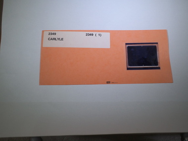 Rutherglen Historical Society
Aperture Card microfilm, Victorian Land Tiltes Office, Parish Plan Carlyle
Town layout of Carlylecard with a single microfilm insertplan, town, boundries, lots, roads -
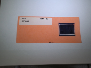 Rutherglen Historical Society
Aperture Card microfilm, Victorian Land Tiltes Office, Parish Plan Carlyle
Town layout of Carlylecard with a single microfilm insertplan, town, boundries, lots, roads -
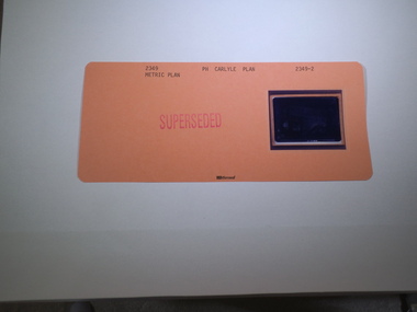 Rutherglen Historical Society
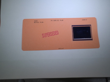
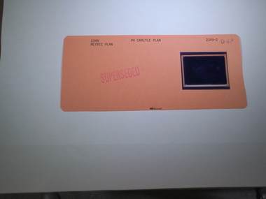
Aperture Card microfilm, Victorian Land Tiltes Office, Parish Plan Carlyle (Superseded)
Town layout of Carlylecard with a single microfilm insertplan, town, boundries, lots, roads -
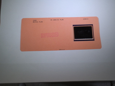 Rutherglen Historical Society
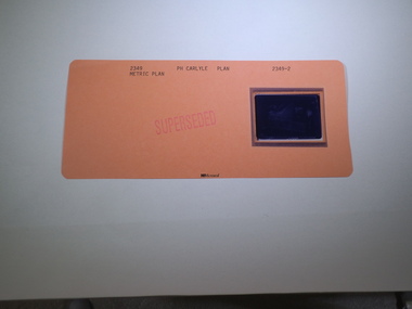
Aperture Card microfilm, Victorian Land Tiltes Office, Parish Plan Carlyle (Superseded)
Town layout of Carlylecard with a single microfilm insertplan, town, boundries, lots, roads -
 Rutherglen Historical Society
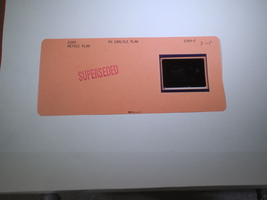
Aperture Card microfilm, Victorian Land Tiltes Office, Parish Plan Carlyle (Superseded)
Town layout of Carlylecard with a single microfilm insertplan, town, boundries, lots, roads -
 Rutherglen Historical Society
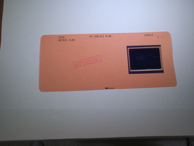
Aperture Card microfilm, Victorian Land Tiltes Office, Parish Plan Carlyle (Superseded)
Town layout of Carlylecard with a single microfilm insertplan, town, boundries, lots, roads -
 Rutherglen Historical Society
Aperture Card microfilm, Victorian Land Tiltes Office, Parish Plan Carlyle (Superseded)
Town layout of Carlylecard with a single microfilm insertplan, town, boundries, lots, roads -
 Rutherglen Historical Society
Aperture Card microfilm, Victorian Land Tiltes Office, Parish Plan Carlyle (Superseded)
Town layout of Carlylecard with a single microfilm insertplan, town, boundries, lots, roads -
 Rutherglen Historical Society
Aperture Card microfilm, Victorian Land Tiltes Office, Parish Plan Carlyle (Superseded)
Town layout of Carlylecard with a single microfilm insertplan, town, boundries, lots, roads -
 Rutherglen Historical Society
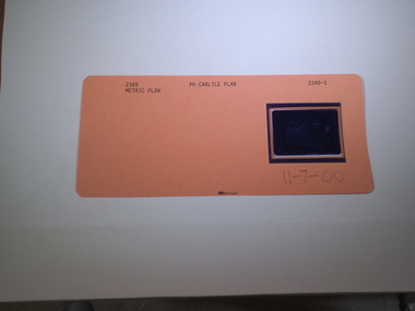
Aperture Card microfilm, Victorian Land Tiltes Office, Parish Plan Carlyle (Superseded), 11/07/2000
Town layout of Carlylecard with a single microfilm insertplan, town, boundries, lots, roads -
 Ballarat Heritage Services
digital photographs, Lisa Gervasoni, Omeo, Victoria, 2017, 2017
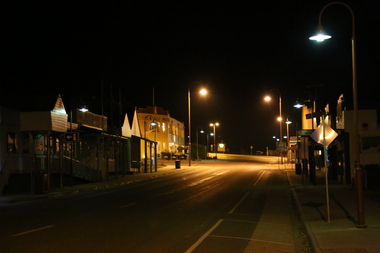
Coloor photograph of a night view in the main street of Omeo.2017, great alpine road, omeo high plains, omeo, high country, streetscape, heritage, night -
 Whitehorse Historical Society Inc.
Photograph, Colombo Street Mitcham, 2006
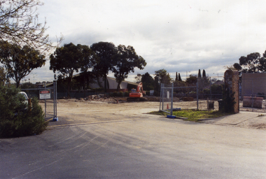
Coloured photo of land for proposed development of a fourteen storey apartment block in Colombo Street, Mitchamcolombo street mitcham, high-rise buildings -
 Whitehorse Historical Society Inc.
Photograph, Colombo Street, Mitcham, 2006
Development of fourteen story apartment block. Given a permit in 2004. Permit not extended on 2007.Coloured photo of land for proposed development of a fourteen storey apartment block in Colombo Street, Mitcham (previously site of Brewer Sporting Goods Manufacturing Goods Factory)colombo street mitcham, high-rise buildings -
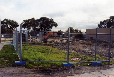
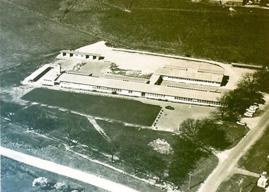 City of Ballarat Libraries
Photograph - Card Box Photographs, Ballarat East High School circa 1965
Aerial view of the Ballarat East High School on the corner of Melbourne Road (now Ballarat - Burrumbeet Rd) and Fussell Street. The campus is now the Woodman's Hill Secondary College.ballarat east high school, woodman's hill secondary college, education, building, public -
 Unions Ballarat
The forgotten rebels of Eureka, Wright, Clare, 2013
Clare Wright writes about the multitude of women who were at the Ballarat goldfields and the critical roles that they played in the goldfields and the Eureka Stockade. Contents Introduction : dust and rattling bones Part 1. Transitions 1. A virgin country 2. Deliverance 3. Crossing the line 4. The road Part 2. Transformations 5. The gold diggers on '54 6. Winners and losers 7. The winter of their discontent 8. Parting with my sex Part 3 : Transgressions 9. Burning down the house 10. High camp 11. Crossing the line (reprise) 12. Bloody Sunday. Relevant to Australian and Ballarat history and especially facts around the story of the Eureka Stockade.Paper; hardcover book. Front cover: blue and white Eureka flag background; white, fawn and blue lettering; sticker (The Stella Prize 2014 Shortlist).Front cover includes title and author's name; quotations from reviewers. Back cover: quotes from reviewers.btlc, ballarat trades hall, ballarat trades and labour council, eureka stockade, women in history, goldfields, gold miners, gold mining - ballarat, history -
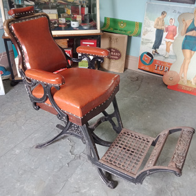 Macarthur & District Historical Society Inc
Furniture - Barber's chair
Barber's chair with a detached board for children to sit on, to modify chair height. -
Numurkah & District Historical Society
Photos / Books / Glasses
1 x Centenary of Num Primary School Book 1879-1979 1 x Back to Numurkah Book 1951 1 x Numurkah Shire Book 1965 Numurkah Shire Glasses Early Road Transport Photos -
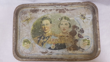 Numurkah & District Historical Society
Commemorative ServingTray (Willow)
Souvenir tray, 1927, Duke and Duchess of York from Betty Bennett's family (Betty Moore). Both Betty and Don Moore were taken to see the parade along St Kilda Road, at age 7 years. Don was hoisted onto his father's shoulders and all he could see were flags waving. They travelled down High St by cable car. Don also rode on the last cable car to Northcote when he was in the services (WW2)Steel Tray with faded pictures of the Duke & Duchess of York and Princess Elizabeth & Princess MargaretWillow Productionmoore family, commemorativ tray, royal family, duke and duchess of york, visit to melbourne -
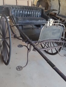 Numurkah & District Historical Society
Ladies Jinker
LADIES PONY GIG – circa early 1900’s) The gig was built by T Rose, North Melbourne. Australian coachbuilders adopted American designs and modified these to suit local conditions, eg mudguards added for muddy country roads. As roads improved, lighter and faster designs were made. These gigs were more comfortable than the normal farm cart / town cart (see nearby butcher’s cart), as they were often sprung for comfort rather than carrying heavy weights. (Donated by: Ivan & Gwen Russell, who purchased it from the Hogan Family, Tatura, in 1998) Ivan & Gwen Russell purchased this jinker from the Hogan Family at Tatura in 1998 "The only information we have is that it was built by T. Rose, North Melbourne. As it is in the original Condition we would like to donate it to the Numurkah Historical society to be displayed for others to enjoy. Black-painted ladies jinker (pony gig), with rubber tyred wheels, light hickory shafts, patterned black upholstery on seatT Rose Buildergig, jinker, horse-drawn vehicle, russell -
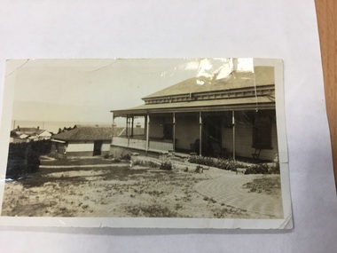 Mordialloc & District Historical Society Inc
Photograph, Slate Roof Timber House. Possibly in High Street, Mordialloc, c1900, c1900
not know Shows typical house in Mordialloc at start of 20th century.Small black & white photograph of timber house with veranda showing some of the garden. Possible road in front of house.On back "Kodak Print" Hand written "MORDIALLOC" Printed "M 906"mordialloc, house, photograph -
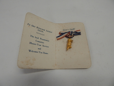 Camperdown RSL Sub Branch
Golden Kookaburra
Public reception for World War 1 Returned Soldiers , Thursday 28th August 1919 at the Mechanics Institute Camperdown. The soldiers were presented with a Golden Kookaburra by the local Repatriation Committee. Further details on trove.nla.gov.au ,search Camperdown Chronicle Saturday 30 August 1919 page 2 "Reception to Soldiers"small folder 45mm x 70 mm containing a Golden Kookaburra pendant 22 mm high The Great War 1914-1918 Camperdown Thursday 28th August 1919 -
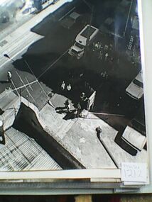 Ambulance Victoria Museum
Photograph, roof top rescue, Circa 1970s
Rescue of injured man in Flinders Street Melbourne, circa 1970s. The name Bill Long has been written on the back of each photograph in this series. Black and white photograph showing fire fighters and ambulance officers placing an accident victim into a 'cherry picker' machine from high building roof. Spectators look on from road. -
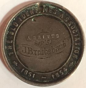 Old Colonists' Association of Ballarat Inc.
Photograph - Photograph - Colour, John Brooksbank's Old Identities' medal
The Old Identities' Association was a forerunner of the Old Colonists' Association Ballarat. John Brooksbank was a very early arrival to Ballarat in September 1851, which was not long after the discovery of gold at Ballarat. J. Brooksbank lost a dog in 1857 "LOST from the Half Way House, Smythe's Creek Road, a black bloodhound and kangaroo dog. Anyone detaining him after this date will be prosecuted. J. BROOKSBANK" (Ballarat Star, 30 December 1857) Another very early identity in Ballarat, James Oddie, advertised the sale of J. Brooksbank's hotel in 1860: "JAMES ODDIE & CO. have received instructions from the Mortgagees, to sell I by auction at their rooms, Dana street, on Thursday, 20th September, at twelve o'clock, All that desirable properly known as the , Halfway House Hotel, Together with all that piece or parcel of ' land situate in the parish of Cardigan and county of Grenville, containing 34 acres 1 rood 26 ½ perches, part of allotment 1, section 6, of said parish, situated on the Ballarat and Smythesdale road, and recently occupied by Mr J. Brooksbank. The property consists of a spacious stone building one story high, strong and substantially built, the internal fittings and arrangements are neat and complete. The house possesses all requisite accommodation for a respectable country hotel. In addition are stockyards, stables &c, all well and securely fenced. Terms at Sale. (Ballarat Star, 20 September 1860) Four years later Brookbank was selling his hotel in Lyons Street Ballarat: "RARE OPPORTUNITY.-FOR SALE the BLACK BULL HOTEL, Lyons street. The proprietor of the above hotel being about entering into another line of business, begs to call the attention of parties looking for a safe and profitable investment, the above having undergone thorough repairs, and is now in good working order and doing a fair share of business. The conditions will, be half cash, balance six, nine, and twelve months. Apply, J. Brooksbank, proprietor, on the premises. (Ballarat Star, 22 October 1864)Colour photograph of a sterling silver medal relating to The Old Identities' Association 1851-1854. The medallion, belonging to John Brooksbank, has a drilled hole at the top suggesting it was worn by the owner at some stage in its life. The medal has been engraved: Arrived "Sep 51 J. Brooksbankold identities association, old colonists' association ballarat, c.a. welch, silversmith, numismatics, j. brooksbank, medal -
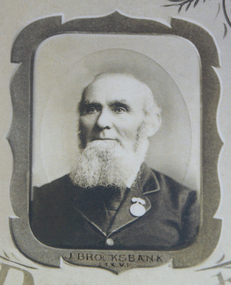 Old Colonists' Association of Ballarat Inc.
Photograph - Photograph - Black and White, John Brooksbank
The Old Identities' Association was a forerunner of the Old Colonists' Association Ballarat. John Brooksbank was a very early arrival to Ballarat in September 1851, which was not long after the discovery of gold at Ballarat. J. Brooksbank lost a dog in 1857 "LOST from the Half Way House, Smythe's Creek Road, a black bloodhound and kangaroo dog. Anyone detaining him after this date will be prosecuted. J. BROOKSBANK" (Ballarat Star, 30 December 1857) Another very early identity in Ballarat, James Oddie, advertised the sale of J. Brooksbank's hotel in 1860: "JAMES ODDIE & CO. have received instructions from the Mortgagees, to sell I by auction at their rooms, Dana street, on Thursday, 20th September, at twelve o'clock, All that desirable properly known as the , Halfway House Hotel, Together with all that piece or parcel of ' land situate in the parish of Cardigan and county of Grenville, containing 34 acres 1 rood 26 ½ perches, part of allotment 1, section 6, of said parish, situated on the Ballarat and Smythesdale road, and recently occupied by Mr J. Brooksbank. The property consists of a spacious stone building one story high, strong and substantially built, the internal fittings and arrangements are neat and complete. The house possesses all requisite accommodation for a respectable country hotel. In addition are stockyards, stables &c, all well and securely fenced. Terms at Sale. (Ballarat Star, 20 September 1860) Four years later Brookbank was selling his hotel in Lyons Street Ballarat: "RARE OPPORTUNITY.-FOR SALE the BLACK BULL HOTEL, Lyons street. The proprietor of the above hotel being about entering into another line of business, begs to call the attention of parties looking for a safe and profitable investment, the above having undergone thorough repairs, and is now in good working order and doing a fair share of business. The conditions will, be half cash, balance six, nine, and twelve months. Apply, J. Brooksbank, proprietor, on the premises. (Ballarat Star, 22 October 1864)Photographic portrait of John Brooksbank from a photographic montage held by the Ballarat Old Colonists' Association.john brooksbank, ballarat old colonists' association, ballarat old colonists' club, old colonists' association -
 Old Colonists' Association of Ballarat Inc.
Photograph - Photograph - Colour, Ballarat Old Colonists' Association Homes, Charles Anderson Grove, Ballarat
HISTORY OF THE BALLARAT OLD COLONISTS' ASSOCIATION HOMES AT CHARLES ANDERSON GROVE, LAKE GARDENS One of the original objectives of the Association was “to provide the shelter of a house for those Pioneers of the Goldfields whom the reverses of fortune have deprived of the means of procuring the comforts of life in their declining years.” While the first home at Charles Anderson Grove was built in 1925 the Association had previously provided relief for needy pioneers from the time it was formed in 1883. Relief included monthly monetary payments, loads of firewood, medical assistance and distribution of Christmas boxes of groceries to deserving pensioners and in some cases payment of burial costs. Records indicate that in September 1922 three of the pensioners being assisted by the Association were accepted as residents in the newly erected Hassell Homes in Gillies Street (now demolished-opposite the High School). The first site for an Asylum for Indigent Members of the Old Colonists' Association was temporarily reserved from sale in October 1891. The site was approximately 28 acres in area in Mt Clear nearly opposite Midvale Shopping Centre in Main Road. The site was heavily timbered and when cleared over 260 tons of wood was sold to the Woah Hawp Gold Mining Company. A set of gates were erected but no homes built, although a plan for this reserve was drawn which showed twenty buildings ranging from one to four unit per building. The reserve was revoked in November 1909. The second site temporarily reserved in November 1909 as an Asylum was in Alfredton and consisted of some 7 acres and was adjacent to land reserved for an Abattoirs for the Ballarat Council. The reserve was revoked in February 1912 as it was deemed more appropriate to be added to the Abattoir site. Council suggested four (4) other sites in exchange for this land and they were inspected by the President, Vice President and Secretary on 22 December 1912. The first site inspected was land on the west side of Creswick Road opposite the brick kilns (now occupied by the showgrounds and oval). The land was described as being good quality, well fenced, no trees, good drainage and ample acreage but some distance from trams. The second site was Perry Park which was described as being good land, well fenced, having frontage to Gillies Street, good drainage and about 26 acres (but subsequently reduced to 10 acres). It was closely planted with Pinus Insignias and Wattle and had easy access from the Botanic Gardens tram. The third site was the North West portion of Victoria Park (corner of Sturt and Gillies Street) and was described as good land, well fenced and drained and well located. The fourth site was the South West corner of Victoria Park and known as Pound Paddock (corner of Winter Street and Gillies Street). It was considered to be low lying and too close to the Abattoir, and was also a considerable distance from trams. While the third site was recommended as the most suitable for the erection of homes it was considered unwise from the point of view as citizens to reduce the acreage of the park and therefore it was recommended that the Perry Park site be asked for as the most acceptable to the Association for the building of homes. The site was eventually temporarily reserved for an Asylum for Indigent Members of the Association in April 1914 with the gates from Mt Clear having been removed to the site a year earlier and eventually erected in 1917 for £12.10.0. In the same year the first 290 pine trees were advertised for removal in July and sold for £16. A sign indicating that the site was reserved for the erection of cottages was erected in September 1917. Stripping of the wattle bark (for tanning) and the cutting of the wood occurred in November 1918 with the land then being leased until it was required for the construction of the first homes in 1924. While the site was the third to be reserved it was the only one which was used for its intended purpose. It was named as Charles Anderson Grove in honour of Charles Anderson who joined the Association in 1918 and was President of the Association from 1942 to 1944. A number of cottages in the Ballarat Old Colonists' Association Retirement Village of Gillies Street, Ballarat.charles anderson grove, old colonists' club, ballarat, old colonists' association, old colonists' homes, retirement village -
 Old Colonists' Association of Ballarat Inc.
Photograph - Image, The History of Charles Anderson and Charles Anderson Grove, Ballarat
Information relating to Charles Anderson and Charles Anderson Grove, Lake Gardens, Ballarat. The Old Colonists' Association Ballarat Inc. is a not for profit charitable organisation providing accommodation for elderly people. It manages a 27 Home retirement village at Charles Anderson Grove, Ballarat. Accommodation is offered at significantly below market rates. It has been providing low cost accommodation to the elderly since the 1920s. The Association Council overseas the running of this facility on a voluntary basis. HISTORY OF THE BALLARAT OLD COLONISTS' ASSOCIATION HOMES AT CHARLES ANDERSON GROVE, LAKE GARDENS One of the original objectives of the Association was “to provide the shelter of a house for those Pioneers of the Goldfields whom the reverses of fortune have deprived of the means of procuring the comforts of life in their declining years.” While the first home at Charles Anderson Grove was built in 1925 the Association had previously provided relief for needy pioneers from the time it was formed in 1883. Relief included monthly monetary payments, loads of firewood, medical assistance and distribution of Christmas boxes of groceries to deserving pensioners and in some cases payment of burial costs. Records indicate that in September 1922 three of the pensioners being assisted by the Association were accepted as residents in the newly erected Hassell Homes in Gillies Street (now demolished-opposite the High School). The first site for an Asylum for Indigent Members of the Old Colonists' Association was temporarily reserved from sale in October 1891. The site was approximately 28 acres in area in Mt Clear nearly opposite Midvale Shopping Centre in Main Road. The site was heavily timbered and when cleared over 260 tons of wood was sold to the Woah Hawp Gold Mining Company. A set of gates were erected but no homes built, although a plan for this reserve was drawn which showed twenty buildings ranging from one to four unit per building. The reserve was revoked in November 1909. The second site temporarily reserved in November 1909 as an Asylum was in Alfredton and consisted of some 7 acres and was adjacent to land reserved for an Abattoirs for the Ballarat Council. The reserve was revoked in February 1912 as it was deemed more appropriate to be added to the Abattoir site. Council suggested four (4) other sites in exchange for this land and they were inspected by the President, Vice President and Secretary on 22 December 1912. The first site inspected was land on the west side of Creswick Road opposite the brick kilns (now occupied by the showgrounds and oval). The land was described as being good quality, well fenced, no trees, good drainage and ample acreage but some distance from trams. The second site was Perry Park which was described as being good land, well fenced, having frontage to Gillies Street, good drainage and about 26 acres (but subsequently reduced to 10 acres). It was closely planted with Pinus Insignias and Wattle and had easy access from the Botanic Gardens tram. The third site was the North West portion of Victoria Park (corner of Sturt and Gillies Street) and was described as good land, well fenced and drained and well located. The fourth site was the South West corner of Victoria Park and known as Pound Paddock (corner of Winter Street and Gillies Street). It was considered to be low lying and too close to the Abattoir, and was also a considerable distance from trams. While the third site was recommended as the most suitable for the erection of homes it was considered unwise from the point of view as citizens to reduce the acreage of the park and therefore it was recommended that the Perry Park site be asked for as the most acceptable to the Association for the building of homes. The site was eventually temporarily reserved for an Asylum for Indigent Members of the Association in April 1914 with the gates from Mt Clear having been removed to the site a year earlier and eventually erected in 1917 for £12.10.0. In the same year the first 290 pine trees were advertised for removal in July and sold for £16. A sign indicating that the site was reserved for the erection of cottages was erected in September 1917. Stripping of the wattle bark (for tanning) and the cutting of the wood occurred in November 1918 with the land then being leased until it was required for the construction of the first homes in 1924. While the site was the third to be reserved it was the only one which was used for its intended purpose. It was named as Charles Anderson Grove in honour of Charles Anderson who joined the Association in 1918 and was President of the Association from 1942 to 1944. CHARLES HENRY GRATTAN ANDERSON C.H.G. Anderson (Electoral Returning Officer) was elected to membership of the Old Colonists' Association, Ballarat, in October 1918. He was elected to the Association Committee in 1926, and appointed Treasurer of the Association on the resignation of F. Ellis until the end of the financial year in 1933. In 1936 Charles Anderson indicated he would not be available for the President's Chair and that he would retire from the Committee owing to pressure of work. C.H.G. Anderson was welcomed as a new member of the Association in 1938, and served as President of the Old Colonists' Association from 1942-1944. Midway through 1949 Charles Anderson was appointed Members Secretary and Manager of the Ballarat Old Colonists' Club at £5.0.0 per week and 10/- for entertainment, to commence work prior to 01 August 1949. He was to do 30 hours per week and be present on Friday and generally on Saturday nights. In 1957 a minute of sympathy was extended to Club Manager Charles Anderson on the loss of his son. In 1958 a bonus of £20.0.0 was paid to Charles Anderson in recognition of his service in assisting the Secretary/Manager taking over under difficult conditions. In March 1964 the Shire of Ballarat would not permit a private road to be named Anderson Grove as Anderson Street already existed in Ballarat but Charles Anderson Grove was deemed acceptable. A recommendation of the Committee was put to the AGM in 1967 that Charles Anderson be made a Life Member. In 1969 an Association meeting observed a minutes silence in memory of Chas Anderson. Charles Anderson was also a Committee member of Ballarat Mechanics' Institute from February 1940 to February 1970. He was President in 1948. Black and white photographic portrait of Charles Anderson.charles anderson, charles anderson grove, ballarat old colonists' club, old colonists' association, ballarat, ballarat mechanics' institute, hassell homes, woah hawp gold mining company, firewood, retirement village -
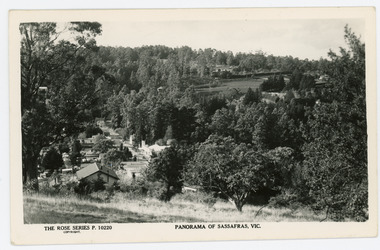 Mt Dandenong & District Historical Society Inc.
Photograph, Panorama of Sassafras, Vic, c1950
Panorama of Sassafras in the 1950s taken from Wallaby Avenue looking down onto the Sassafras Cabaret building. Rostrevor can be seen at centre top.Black and white Rose Series postcard P. 10220 showing a view from high down the Main Street of Sassafras looking north towards Olinda.On reverse POST CARD. A Real Photograph. Produced in Australia.rose series, postcard, sassafras, cabaret, wallaby avenue, rostrevor -
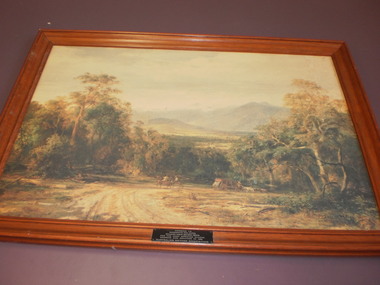 Wangaratta High School
WHS Art, 1986
Landscape painting of an Australian country road with horses and carriages, with a bushland background, in a brown wooden frame. Awarded to Wangaratta High School-Goulburn north east region, by the Australian Natives' Association for the most improved school gardens and grounds in 1986 -
 Wangaratta High School
WHS Yearbook -Korrumbeia, 1976
Cream yearbook with a full page black and white image on the cover depicting the WHS entry gates open and a dirt road leading into the school -
 Royal District Nursing Service (now known as Bolton Clarke)
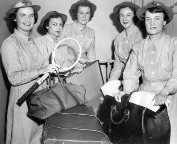
Photograph - Photograph, black and white, 11.1953
The MDNS Sisters are packing their belongs ready to move from their current Nurses Home at 39 Victoria Parade, Collingwood to their new Nurses Home and Headquarters situated at 452 St Kilda Road, Melbourne, then known as 'Airlie'. From its founding in 1885 until 1891 the Trained nurses (Nurses) of the Melbourne District Nursing Society (MDNS) worked from their own homes which were located in the vicinity of their areas (districts). The Committee meetings were held at the Religious Tract Society rooms at Queen’s walk, off Swanston Street and then at the Library Room at the Melbourne Town Hall. The Annual General Meeting was held at the Town Hall. In November 1891 MDNS was able to rent a two story terraced house at 66 Cardigan Street, Carlton, at £65 a year, which contained accommodation for three Nurses and one pupil nurse as well as being used as their Headquarters. They left from their Nurses Home each morning and returned at the end of their shift to write up their book work before retiring for the day. Three years later they moved into a larger terraced house at 49 Drummond Street Carlton which was rented at ‘a very moderate rental’. There was a Board room, apartments for the Nurses and pupil nurse, a large dispensary which patients could attend each evening to have prescriptions signed and bottles refilled with ‘homely remedies’ and elixirs, which were administered for e.g. to Consumptive cases. Doctor’s prescriptions were filled at the Pharmacy. Cupboards containing donated blankets and bedclothes for needy patients were kept in this room, and it was here where the Nurses kept their nursing bags which were refilled at the end of each shift ready for any emergency and for the next day. A list of Doctors the Nurses could call was kept by the telephone. The home also had a kitchen where nourishing soup was made and distributed twice a week to the needy. Milk was also distributed when needed. In 1902 they moved into rented premises at 188 Leicester Street, Carlton and two years later, in 1904, to premises at 5 Royal Terrace, Nicholson Street, Fitzroy where they remained for ten years. In June 1914 at last the Society had sufficient funds to purchase their own terraced premises, ‘Floraston’ 39 Victoria Parade, Collingwood which was their Headquarters and Nurses Home. In 1926 the After-Care Home for recovering patients, (later called After-Care Hospital) was built by the Society next door, running from 41-47 Victoria Parade (became No. 45). There were now two divisions with the After Care having their owned Trained nurses (Sisters) and the District Division of Trained nurses (Sisters) who continued to live at No. 39. In November 1953 the Sisters working in the District Nursing Division moved into their new Headquarters and Nurses Home at 452 St. Kilda Road, Melbourne. In 1957 this Division changed its name to the Melbourne District Nursing Service when it separated from the After-Care Hospital. It was given Royal patronage in 1966 and became Royal District Nursing Service (RDNS). As it expanded, and now with Centres opening throughout the suburbs, the Nurses Home at 452 closed and those rooms used for administrative purposes. It now had outlying districts to service, and with a full fleet of District cars, the Sisters lived in their own homes and visited their closest District Centre each morning to collect their work for the day and returned there at the end of their community duties to do their administrative work. On April the 1st 1996 RDNS Head Office relocated to 31 Alma Road, St. Kilda. Standing in a semi circle of this photograph are 5 Melbourne District Nursing Society (MDNS) Sisters in their long sleeve grey uniform dresses which have a belt, peaked collars and white buttons down the centre. They are wearing their grey brimmed hats with a central Maltese cross on the light colour headband over their short dark curled hair. From Left to Right are Sisters Marianne Metcalf who is smiling and is holding a tennis racket and soft sided oblong travel bag which has two leather straps and handle in her right hand; it is resting on a closed case, which has two leather straps across the lid; this sits in front of her. Next is Gerda Oppenheim who is looking serious and has her right hand on the top of the lid of an open case in front of her, then Beryl Rowley, who is smiling and has her hands on a narrow white metal horizontal pole which has a vertical pole attached. Next is Marcia Parrat who is smiling and is holding a piece of white linen on the open case, and next, on the far right, is Florence Hoey who is holding a piece of white linen on top of an open hard leather travelling bag which is sitting in front of her next to the closed case. melbourne district nursing society, mdns, mdns headquarters, sister marianne metcalf, sister gerda oppenheim, sister beryl rowley, sister marcia parrat, sister florence hoey, royal district nursing service, rdns