Showing 6436 items matching "housing"
-
 Bendigo Historical Society Inc.
Document - NORMAN OLIVER COLLECTION: MAYOR SPEAKS 14 MAY 1965
The Norman Oliver collection. Norman Oliver was three times Mayor of Bendigo - 1950-51, 1964-65, 1970-71. Four typed pages titled 'Mayor Speaks May 14th'. Topics include : Bendigo Technical College Speech Night, visit from the Town Clerk of Timaru N.Z., the Victorian Promotion Committee and development of industry and employment in Bendigo, the need for worker housing, the sponsorship of Bendigo Apex Club of the 'Bring out a Briton' campaign, proposed Bendigo Aerodrome, Justice of the Peace issues, crude language in library books, and the weights and measures bureaucracy. There appears to be a page missing from these notes.bendigo, council, report, norman joseph oliver , councillor norman oliver. mayor of bendigo. bendigo technical college. victorian promotions committee. bendigo apex club. -
 Melbourne Tram Museum
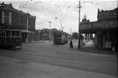
Negative, Wal Jack, 24/11/1941 12:00:00 AM
Black and white negative, by Wal Jack, of S 160 (St Georges Road) and W2 455 (West Preston 10) at the intersection of Barkly St and St Georges Road, North Fitzroy. The Trolley Pole is turned on S 160 for the car to return to Lygon St along Holden St. On a wall above the W2 is written "Gone to Berlin" On the corner is a Cash Grocer, advertising McAlpin's Flour, Velvet Soap. In the background is a bus stop sign and housing that has been built since the demolition and sale of the former Cable Tram depot. Photo dated 1-9-1941, in the Wal Jack album.trams, tramways, s class, w2 class, holden st, st georges road, barkly st, route 10, tram 160, tram 455 -
 Warrnambool and District Historical Society Inc.
Poster, Lyndoch Sub-Division
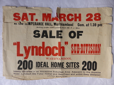
This is a poster advertising the sale of the Lyndoch sub-division in Warrnambool with the sale of 200 housing sites. The sale took place about 1958 with the land sold by Frederick Gill, a Warrnambool jeweller. The land was previously owned by George Rolfe who had acquired the land near the mouth of the Hopkins River in the 1880s and named the property ‘Lyndoch’. He bought the surrounding land at a later time. This sub-division came to be known as the Gill Estate. It was a valuable site as many of the allotments fronted the sea and others were adjacent to the Hopkins River. This poster, although tattered, is of interest as it has many details of the Gill Estate sub-division and will be useful to researchers. This is a cream-coloured paper poster with black and red printing. The poster has a small map in a circle shape showing the location of the streets and a larger map section showing the streets and the allotments to be sold. The poster is in two pieces and the edges are torn and, in some sections, missing. The streets map has some pencil annotations. history of warrnambool, lyndoch, warrnambool, george rolfe, frederick gill -
 Warrnambool and District Historical Society Inc.
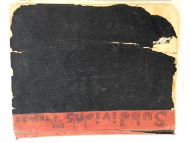
Book, Subdivision No 1 to 1420, 1930s
This is an exercise book listing subdivisions in Warrnambool from 1935 to 1977. There are 1420 entries. It gives details of the subdivisions – plan number, street, section number, allotment number, date, owner, solicitor and Titles Office number. The book is completely filled and today this information would be held in the Warrnambool City Council offices per electronic data storage. Warrnambool, founded in 1847, became a Municipality in 1856, a Borough in 1863, a Town in 1883 and a City in 1918. Subdivisions of land in the city continue to be made regularly for housing and business purposes.This book is of great historic interest because it details the subdivisions in the City of Warrnambool from 1935 to 1977. It shows the continuing growth of the city, particularly after World War Two. It will be a very useful resource for researchers. This is an exercise book with a black cardboard cover and red binding. It contains a list of City of Warrnambool subdivisions from 1935 to 1977. The cover and some of the pages are torn and ragged and the binding has come apart and has been glued together in places. The pages are ruled with blue and red lines. The pages contain handwritten material in black and blue ink. Front Cover: ‘Subdivions(sic), Nos 1 to 1420’ Inside Front Cover: ‘City of Warrnambool Subdivisions’ warrnambool city council, warrnambool subdivisions -
 Warrnambool and District Historical Society Inc.
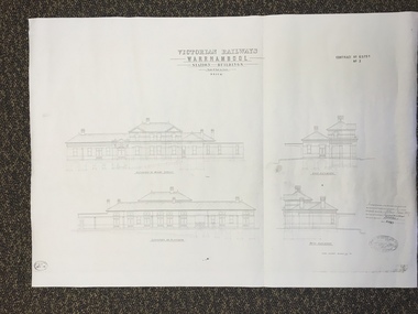
Map, Victorian Railway W'bool No1 & No2, 1897
These two sheets show the 1897 plans drawn up by the Victorian Railways for the erection of the Warrnambool Railway Station building. It is a two-storey building still existing today. The railway came to Warrnambool in 1890 and they must have used temporary buildings for seven years before this railway building was erected. It had offices, booking counter and public facilities on the ground floor and housing for the Station Master on the first floor. The building erected was a typical design for country town railway stations and many of similar design were erected in the 1880s and 90s. These plans are important because they show clearly the design of the Warrnambool Railway Station buildings when they were first erected in the 1890s.They will be very useful for researchers. The coming of the railway was a significant event in Warrnambool’s history and did much to make the port and shipping a less viable proposition.These are two architect’s plans and drawings of the Warrnambool Railway Station building (1897). The drawings are black and white and the first plan shows the ground floor plan and the first floor plan and the outbuildings. The second plan shows drawings of the building with its elevation to the platform and its elevation to Merri Street. There are two stamps of the Railways Department, Melbourne. These are copies, not originals. ‘Victorian Railways, Warrnambool, Station Buildings, Scale 8 feet to one inch, Contract No. 6379B (Nos. 1 and 2)’warrnambool, railway station buildings -
 Warrnambool and District Historical Society Inc.
Booklet, Allansford Progress Association, Second half of 20th century
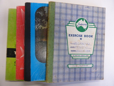
These four exercise books give documentation on the activities of the Allansford Progress Association (1966 to 1988). Allansford is a settlement about 9 kilometres from Warrnambool and most of the town area is now within the boundaries of the Warrnambool City Council. The association was re-formed in November 1966 after the demise of an earlier group. The members of the group campaigned in areas of local concern – T. V. reception, drainage and sewerage, postal services, sports facilities including the development of the Speedway, housing development, road proposals, waste management and disaster plans. These books are of interest in that they provide an overview of the history of a local organization. They will be useful for research. These are four exercise books - three Minutes books, and one Accounts book, from the Allansford Progress Association (1966-1988). The exercise books have coloured covers, (blue and white checkered, green, red and blue). Two are bound with tape and two are stapled. There are some loose sheets in all of the books. All the entries are handwritten. On front covers: ‘Allansford Progress Association’allansford progress association, history of allansford, history of warrnambool -
 Glen Eira Historical Society
Photograph - Elsternwick
This file contains three items. Photocopied and three page retyped article, undated c.1930s and source unknown from Real Estate Agent Philippe Batters 03/09/1997. Three page document from Keith James Smith, undated, on research on Elsternwick and Glen Huntly Road shops and traders. Three articles from THE AGE 13/05/2000 and 15-16/02/2013 and MELB BAYSIDE WEEKLY 03/11/2010 giving snap shots of Elsternwick housing and facts.batters philippe, real estate agents, elsternwick, paddocks, glen huntly road, walter kelly, elsternwick park, slaughter yards, glen eira roads, point ormond, glenhuntly railway station, nepean highway, grange road, holdsworth’s jewellers, staniland grove, coles store, shops, orrong road, fosseys, hattams mensware, woolworths, dalgarnos crockery and kitchenware, chapmans gifts, garth’s shoe store, garth jack, allen’s furniture and auction rooms, elsternwick market, adam’s cakes, mr. green’s pet shop, turner mr., grocer shop, moores lendring library, hopetown gardens, gardens, jack hatheralls butchershop, butchers, chinese laundry, chinese community, laundries, mr. & mrs. darbyshires milkbar, st. johns church, kooyong road, hasseles garage, garages, royal parade, glenhuntly, camden, hawthorn road, blacksmiths, camden town, dolls hospital, caulfield state school 773, independent picture, theatres, camden theatre, southern indoor bowl centre, larch street, montessorie school, collins milk bar, milk bars, collins lin, hartrick miss, armond mr., lennie mr., rothells sausage factory, north road, red bus service transport, furlonger miss, dance studio, moran and cato grocery, cato family, newsagent, tozer brook, furniture store, green gables american style soda fountain and milk bar, hoyts renown theatre, state savings bank, riddell parade, clarence street, aileen avenue, smith keith james, camden town, sports club, peer gary, gary peer & associates, brukarz jack, ray white real estate, real estate agents, classic cinema theatres, st. george’s road, elizabeth street, allison road, gladstone park, myrtle street, victoria street, caulfield, st kilda east, lisbon house, orrong road, house names, rippon lea estate, caulfield south, carnegie, gordon street, carre street, main street, clarence street, elsternwick club, jewish holocaust museum, daily planet, brothels, wesley college, elsternwick primary, st. joseph’s primary, scholem aleichen college, liebler yavneh, hopetoun gardens, harleston park -
 RMIT Design Archives
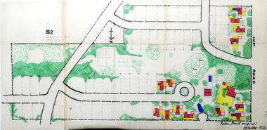
Work on paper - Architectural drawings, Colour plan of Lum road estate, 1970-1986
This plan of Lum Road Estate includes layout of roads, gardens, building and carparks. From 1970 until August 1971 Robin Boyd and his practice Romberg & Boyd Architects worked on designs for housing on the Lum Road Estate, Wheelers Hill. Berenice Harris, Linley Vellacott and Karl Fender drew many of the sketch plans for the project homes, while Robin Boyd drew the perspectives. This colour plan of the estate was drawn by Robin Boyd, but not signed. Frederick Romberg later annotated the drawing with details of its authorship. Colour plan of Lum road estate. Includes layout of roads, gardens, buildings and flora.Inscribed lower right on recto in black ink, 'Robin Boyd original / 12/6/86 F.R' ; Inscriber upper left on recto, grey pencil, '3400'.architecture, design, rmit design archives, domestic architecture -
 Kew Historical Society Inc
Postcard - Kew East State School No.3161, 35 Kitchener Street, c.1927
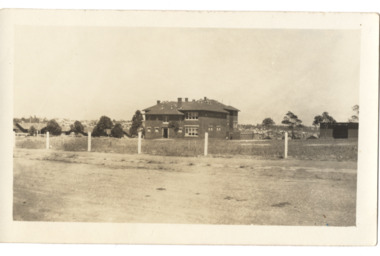
What is now Kew East Primary School was opened on its current site in Kitchener Street in 1923. The Kew East and Mont Albert Heritage Gap Study (August 2020) established that: 'Kew East Primary School No. 3136 is historically significant for the evidence it provides of an early phase in the development of Kew East which gathered momentum from the 1920s, as housing developed rapidly and the population increased in response to the extension of the High Street tram to Harp Road then Burke Road then improved tram connections between the area and the city.'A rare and early photograph of the school taken four years after its construction. Small, sepia coloured photographic positive of East Kew State School. The two storey red brick building was opened in 1923. This view, three years after its construction shows preliminary fencing and undeveloped playing grounds.schools -- kew east (vic.), government schools -- kew -- kew east, strathalbyn street -
 Friends of Westgarthtown
Painting, John Borrack, Ziebells, German Lane, South View
Painted from Gardenia Road. The extensive farm complex on the right. (Western side of Gardenia Road). was demolished in 1972 for housing development. Buildings shown are cowshed, hay barn, engine shed and stables. Painted in the late afternoon, the lengthening shadows and lowering sky, could presage the ominous fate awaiting the farm with development. The Ziebell Farm was known as “The Pines†and sadly none of the many that proliferated there remain. Today they would be equivalent to those at the cemetery, having been planted at the same time. Provenance: John Borrack CollectionWatercolour depicting Ziebell Farmhouse from the north, Thomastown and Mernda. In gold frame with cream border.Artist signature: John Borrack; 70's Ziebells German Lane South Viewillustrations, watercolours, john borrack, ziebell, watercolour, painting -
City of Kingston
Photograph - Black and white, 27 February 1964
Cheltenham is a suburb in the City of Kingston that was originally established as a rural market gardening community. The area is bordered by Highett. The previous market gardens, farms and paddocks have gradually been sub-divided into housing and industrial estates. The Methodist Children's Home Methodist Homes for Children and St John of God Training Centre on the site of the future Southland shopping centre has not yet been demolished. The recently built Cheltenham High School is visible and the increased urbansation of the area is evident. Some farmland remains including the Le Page homestead.The developing urban area of Cheltenham within the City of Kingston. This image illustrates the mid-century urban sprawl of of Cheltenham and the subdivision of market gardens within the municipality and the changing demographic of the district as new houses are constructed and infrastructure established.Aerial photograph of the suburbs of Cheltenham and Highett within the City of Kingston. Highett Gas Works (top left); Bernard Street, Cheltenham (top right); Weatherall Road (bottom left): Elliott and Cobham Streets Cheltenham (bottom right).White handwritten: X Vic.1831 White type: MELBOURNE 1963 PROJECT RUN23 [underlined] 27-2-64 LENS 205 152-70 M/M 5.150 [arrow] White handwritten: X 166 cheltenham, highett, urbanisation -
 Melbourne Legacy
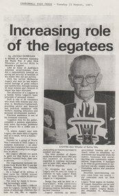
Document - Article, Increasing role of the legatees
An article from the Camberwell Free Press in 1987 of an interview with Legatee Dick Wheeler. He tells of the sense of wartime mateship that led him to join Legacy. He was one of 30 Legatees that worked with widows and children in Hawthorn/Camberwell area providing advice and financial and practical assistance with welfare, housing, education and personal development matters. The article was part of an album of past presidents from 1965 to 1989. The folder included biographical details and obituaries, eulogies and death notices of prominent Legatees. The items have been catalogued separately.A record of a newspaper article about Legacy and Dick Wheeler, a past president of Legacy. The information was collected to record the lives of prominent legatees in a folder.Photocopy of an article from the Camberwell Free Press Tuesday 25 August 1987 of an interview with Dick Wheeler.past presidents, dick wheeler -
 Melbourne Tram Museum
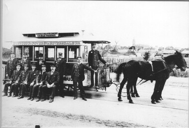
Photograph - Horse tram & crew - Auburn Road
Photo shows one of the horse trams and staff that operated the line that ran from Hawthorn Bridge via Burwood Road, Power Street, and Riversdale Road to Auburn Road, opening in 1890. There are 8 uniformed men and three officers in the photograph. In the background are many undeveloped housing blocks, and the Hawthorn Town Hall tower. The tramway operated until 1916 when it was replaced by an electric tram. See item 6159 for a wider view showing a man at the rear of the tram used in the 1989 Australia Post Stamp Fair.Yields information about the crews that worked the Hawthorn Bridge to Auburn Road horse tram service.Black and white print mounted with in pink coloured card with bevelled edges.Has a caption which is incorrect.tramways, tramcars, horse trams, hawthorn, crews, auburn road, riversdale road, trams -
 Phillip Island and District Historical Society Inc.
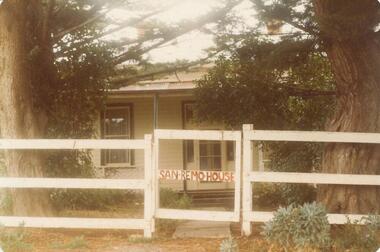
Photograph, 1880's
San Remo house built by Charles Grayden 1880? Possibly Miss Elms' home.Coloured photograph of front of house behind two Cypress Pines - post and rail fence across foreground.San Remo house in red on gatelocal history, photography, photographs, slides, film, san remo, local area development by europeans, housing, coloured photograph, commercial development san remo, dwellings -
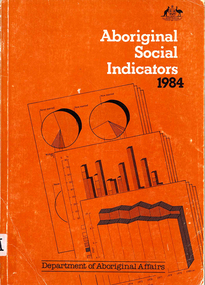 Victorian Aboriginal Corporation for Languages
Book, Department of Aboriginal Affairs, Aboriginal social indicators 1984, 1984
maps, b&w photographs, tables, graphsstatistics, population, land, health, housing, education, employment, income, legal, finance, sport and recreation -
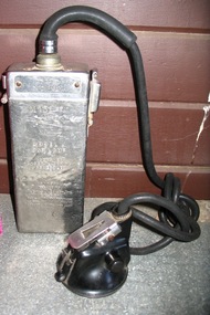 Parks Victoria - State Coal Mine - Wonthaggi
Lamp, Thomas A Edison
Used in S.C.M by an unknown minerStainless steel battery case, black lead to lamp fitting. See (SCM 0938) for printed manual.On front of lamp fitting " EDISON SAFETY LAMP MFD. BY THOMAS A. EDISON. INC. WEST ORANGE. N.J. UNITED STATES OF AMERICA" On top of battery case "EDISON" The side of the top of the battery case has "365" stamped on it showing that it was not the original top. The battery case has "M78". Side of battery has the "Thomas A Edison" seal. Below that reads "MODEL J CAP LAMP Approved Under Lighting Schedule Approval issued to THOMAS A EDISON CAUTION The battery and headpiece housings shall not be unlocked or opened by the lamp user." -
 Eltham District Historical Society Inc
Document - Series Listing, Fraser Faithfull et al, Series 13: Eltham Shire Photograph Album 1985, 2000
Series consists of 174 colour and B&W photographs of sites and activities in the Shire of Eltham. Most shots are 150mm by 100, though there are a number of smaller shots laid out in montages, and 6 large (A4 size) colour shots. Subjects documented include the Eltham Library, Eltham Lower Park, Eltham Senior Citizens Centre, Housing Development, the Council Depot, Shire Offices, Eltham Child Care Centre, Miniature Railway, Community Centre, the Bike Track, a Citizenship Ceremony, Shillingham Cottage, Eltham Town Park and other sites.shire of eltham archives, series listing -
 Eltham District Historical Society Inc
Negative - Photograph, Eltham Shire Council, Possibly a non-compliant house in Simms Road, Kinglake, c.1989
Facebook comments suggested this location may be a cabinetmaker by the name of Cook out the back of Panton Hill. Another comment recalled this man as a visitor to Montsalvat as a friend of the late poet, Geoffrey Egglestone. It is believed his name is Mizza. He is a Bohemium Poet. Also a frequent visitor to the St Andrews market. Photos taken by Eltham Shire Council officers most likely during an inspection of the property for non compliance. Other images on the roll of film are of Council Health officers undergoing food inspections at the shops, maternal health services and housing estate development inspectionsRoll of 35mm colour negative film, 6 strips Frames 3 through 9Fuji 100eltham shire council, shire of eltham, 1989, atlantic ethyl, sheds, signs, unidentified, houses, kinglake, simms road -
 Kew Historical Society Inc
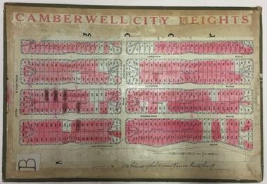
Plan - Subdivision Plan, Jas R Mathers Son & McMillan, Camberwell City Heights, 1922
"Following the 1919 amalgamation of suburban tramway trusts, an electrified tram service extended along Doncaster Road. Housing estates such as the 1919 Balwyn Park Estate, 1922 Hillcrest Estate and the Camberwell City Heights Estate, also 1922, quickly followed. These estates were built over by expansive suburban villas, set in fine gardens and along tree-lined streets. North Balwyn, largely constructed since 1933, was typified by even grander houses, many of them in the 'ocean liner' style and seen at their most distinctive in the Riverview Estate." (Source; 'Balwyn' in eMelbourne)Portions of subdivision plan mounted on both sides of cardboard sheet. Coloured pink, probably to show allotments sold. Area covered: Doncaster Road, Mountainview Road, Panoramic Road, Cityview Road, Longview Road, Riverview Road, Hillview Road, Bulleen Road. Includes location diagram showing railway lines and existing and proposed tram routes.Cardboard backing has advertisement for "Tillock's soluble coffee"subdivision plans -- camberwell (vic.), camberwell city heights subdivision -
 Melton City Libraries
Letter, Letter to Martha Myers, Unknown
Letter was sent to Burnbank, former Ann Dowling (Miers) 1866 Crown Grant. In 1867 she married Henri Miers and their house was located on the site near the Myers Gully part of Ryans Creek. Built in 1867 and later named “Burnbank” by Martha Myers after the Street in Ballarat were she lived before arriving in Melton in 1907. “Burnbank” was vacated by Martha to her new house built on the family land in McKenzie Street. A demolition order imposed by the Housing Commission and it was pulled down by the family in 1969. It was the home of the family and stood for over 100 year.Letter from Edna Barrie and Bruce Myers, children of Martha Myerslocal identities -
Glen Eira Historical Society
Album - Photograph Album, Beauville Estate Album, 2001
Originally labelled "Beauville Estate, Established 1936, Still Thriving 65 years on, 10th March 2001", the Beauville Estate Album contains colour photographs of houses in the Estate. They were taken around the time of the Beauville Estate’s 65th Heritage Celebration held on 10/03/2001 and donated to the Caulfield Historical Society shortly afterwards. Photographer Bev Baxter. Glen Eira’s Heritage Management Plan by Andrew Ward (1996) Vol 2 p78 states that by the end of 1934, the first 3 houses had been built in this housing estate.City of Glen Eira’s Heritage Management Plan Vol 2 p79 (p84 of the pdf version) – HO12 Beauville Estate and environs, Murrumbeena: The Beauville Historic Area is important at the State level as the first large housing estate undertaken by the AV Jennings Construction Co, later Jennings Group Limited, Victoria’s largest home builder. It is important also as a very early estate development incorporating a range of features other than houses and including made roads, shops and recreation facilities. In this respect it was the forerunner of the comprehensively planned housing estate of the post war era. The estate is distinguished by its aesthetic values, as is the earlier and comparable Hillcrest Estate, which are formed by a combination of restrained diversity in house styles, with the exception of no. 30 in the emerging International style, and by a landscaped garden environment.Colour photographs of house exteriors, as well as parks and tennis courts on the Beauville Estate. murrumbeena, houses, beauville avenue, architectural styles, 1930's, inter war style, a.v. jennings, av jennings, jennings, brick houses, beauville estate, murrumbeena road, lindsay avenue, gloucester court, dalny road, a v jennings construction co, beauville estate heritage area, glen eira city council, architectural features, plans, shops, residential development, tennis courts, housing estates, builders, building regulations, local government, commercial development, history, maps, photographs, commercial establishments, jennings group limited, land subdivision, gardens, beauville historic area, sir albert victor jennings -
 Eltham District Historical Society Inc
Colour Print, David Taylor, Falkiner's Cottage, Ely Street, Eltham, c.1976
Viewed from the western boundary at the rear of Eltham High School looking southwest across part of what would be become the Cronus Court housing development. Aerial photos for 1976 reflect the undeveloped landscape as viewed. By 1981 the estate was well established with all houses built. Falkiner Cottage, also known as Maynard's Cottage. Falkiner was the original owner and Maynard the last owner. The cottage was located on the north side of Ely Street where present day #19 is situated. The cottage ran in a north-south orientation with an easterly aspect down the hill.david taylor collection, eltham, eltham high school, cronus court, ely street, falkiner cottage -
 Bendigo Historical Society Inc.
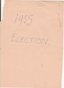
Document - NORMAN OLIVER COLLECTION: SPEECH NOTES. VICTORIAN STATE ELECTION 1955
The Norman Oliver collection. Norman Oliver was three times Mayor of Bendigo - 1950-51, 1964-65, 1970-71. Two copies of seven pages of typed notes for a campaign speech in the Victorian state election 1955. Oliver was standing as a Country Party candidate for a seat in the Legislative Assembly. This speech appears to have been given on 3BO as it begins 'Good afternoon, listeners ..'and asks for their vote 'next Saturday'. He replies to criticism that he is anti-working class, his education plans for Bendigo, agricultural science and trade, Bendigo's housing shortage, road policies, drainage issues with the Bendigo Creek. Additions and corrections in blue ink.bendigo, hospital, speech notes, norman joseph oliver , councillor norman oliver. mayor of bendigo. 3bo. victorian state election 1955. country party. -
 Bendigo Historical Society Inc.
Document - NORMAN OLIVER COLLECTION: SPEECH NOTES 1955 POLICY SPEECH. LEGISLATIVE ASSEMBLY OF VICTORIA
The Norman Oliver collection. Norman Oliver was three times Mayor of Bendigo - 1950-51, 1964-65, 1970-71. Twenty one pages of typed speech notes for 'my policy speech on the occasion of this 1955 election for the Legislative Assembly of the State of Victoria'. Corrections and additions in black ink. Topics and policies mentioned in the speech include : Rotary, Housing, old people, gaols and institutions, roads and motor cars, parking and traffic confusion, education (university for Bendigo), industries, libraries, power and transport, water supply, sewerage, swimming pools, and the dangers of Communism. Norman Oliver was standing as a candidate for the Country Party. There is a front page with '1955 Election' written in blue pen.bendigo, hospital, speech notes, norman joseph oliver , councillor norman oliver. mayor of bendigo. victorian state election 1955. country party. -
 Warrnambool and District Historical Society Inc.
Souvenir - Personal item: Rouge holder
This is a souvenir of the British Empire Exhibition of 1925. This exhibition, designed to showcase the industrial and natural resources of the countries in the British Empire was on a 216 acre site at Wembley, England. In 1923 the Wembley Stadium was completed and the F.A. Cup Final was held there. In 1924 the Exhibition was opened by King George V in a first ever radio broadcast by a British monarch. There were Palaces of Industry, Engineering, Horticulture and Art and Pavilions housing exhibits from most countries in the British Empire. 17 million people visited in 1923 and there were 11 million visitors in 1925 when the exhibiton was re-developed. Wembley Stadium was reconstructed in 2002. This item has no local provenance but is of some interest because of its connection to the British Empire Exhibition of 1925. It is a good example of the type of souvenir that was bought by visitors to the Exhibition. This is an enamelled metal container, circular (octagonal on the outside edges) in shape with a short handle. The central area is slightly recessed to take a small amount of rouge (a red powder compound for the face, usually the cheeks). A pad to apply the rouge to the face is missing. There is a metal hinged lid with a clip and a small ring at the end of the handle, possibly to contain a chain for it to hang around the neck. The wording on the front is black on a blue and green enamelled backgroundRaised image of a lion with the words underneath ‘British Empire Exhibition, 1925’rouge holder, british empire exhibition 1925 -
 Kiewa Valley Historical Society
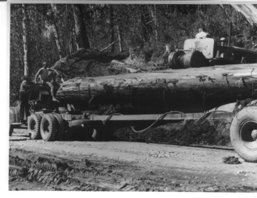
Photograph, logging at McKay Creek, Logging at McKay Creek, 1949/50
This photo was most likely taken at the site of the proposed McKay Creek Power Station. Excavation of this site was commenced in 1951 but an access road (a rough, narrow track) was put it in 1948 and widened in 1954. The State Electricity Commission would have milled logs from this area at their mill at Howman's Gap. The timber was used for building of housing and camps and provided a much needed resource as there was a general shortage of this commodity. The power station was relocated underground owing to repeated problems with landslides in the area. Restricted financial resources and the repositioning of the power station retarded construction activities and it was not completed until early 1961. An historical pictorial record of the type of machinery used in the 1950's - logging truck with bogie attached, the bull dozer and winch for hauling logs to the truck and note the lack of protective clothing!Black and white photograph showing a logging truck, bogie and bull dozer with winch for hauling the logs to the truck. Two men are on the truck, a driver on the bull dozer and a large log on the bogie. Hand written on the back of photo "Logging at McKay Creek".logging, mckay creek, timber, machinery -
 Port Melbourne Historical & Preservation Society
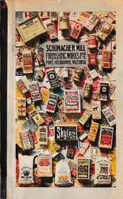
Book, D. W. Paterson Co. Pty. Ltd, Schumacher Mill Furnishing Works Pty Ltd Port Melbourne, Victoria, c.1940
The 38 page illustrated catalogue from Schumacher Mill Furnishing Works contains b & W photographs of their mixing, packing and sifting machinery. Each photograph is accompanied by a description & detailed statistics. The firm was founded in 1896 in Port Melbourne by German immigrant, Otto Charles SCHUMACHER and occupied the site on the corner of Graham Street & Esplanade East. On his father's death the business was taken over by his son, Ferdinand SCHUMACHER , who died just 8 months later. The firm continued trading until 1950 and the factory was demolished in 1985 to make way for social housing.Blue bound book with a coloured cover that has photographs of many of the items produced by Schumacher Mill machinery.otto c schumacher, schumacher mill furnishing works, industry - manufacturing, ferdinand schumacher -
![V&A Gallery of Fashion / [by] Wilcox and Lister (eds)](/media/collectors/550653872162f11fb04854aa/items/5ed04f95dcf9cd08346bd8c0/item-media/5ed050a9dcf9cd08346be871/item-fit-380x285.jpg) Kew Historical Society Inc
Kew Historical Society IncBook, V & A Publishing, V&A Gallery of Fashion, 2016
EXHIBITION CATALOGUES & SPECIFIC COLLECTIONS. Spanning four centuries, the V&A's Fashion Collection is the most comprehensive in the world, housing unrivaled collections of dress,accessories, shoes and hats from the 17th century to the present day. This thoroughly revised and redesigned edition shows the collection, from rare eighteenth-century gowns and exquisite bodices to 1930s evening wear, post-war couture, and showstopping ensembles by contemporary designers. Among the designers featured are Charles Frederick Worth, Madeleine Vionnet, Coco Chanel, Cristobal Balenciaga, Christian Dior, Mary Quant, Stephen Jones, Vivienne Westwood, and Alexander McQueen.176 pages : illustrations (chiefly colour) ; 27 cm.non-fictionEXHIBITION CATALOGUES & SPECIFIC COLLECTIONS. Spanning four centuries, the V&A's Fashion Collection is the most comprehensive in the world, housing unrivaled collections of dress,accessories, shoes and hats from the 17th century to the present day. This thoroughly revised and redesigned edition shows the collection, from rare eighteenth-century gowns and exquisite bodices to 1930s evening wear, post-war couture, and showstopping ensembles by contemporary designers. Among the designers featured are Charles Frederick Worth, Madeleine Vionnet, Coco Chanel, Cristobal Balenciaga, Christian Dior, Mary Quant, Stephen Jones, Vivienne Westwood, and Alexander McQueen.fashion design - history - exhibitions., fashion - history - pictorial works., victoria and albert museum -- catalogs. -
 Vision Australia
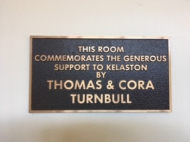
Plaque - Image, Kelaston plaques, 1993
Donations for structural improvements were often acknowledged via plaques. These plaques were on the walls of Kelaston then later the Vision Australia office in Ballarat until it closed in 2021. Anna Jane Bolte was a resident of Kelaston whose son, Sir Henry Bolte became the longest serving Victorian Premier. William Buckland Trust supported safe housing for vulnerable Australians, such as the residents of Kelaston. Other generous local donors who were also acknowledged are Thomas & Cora Turnbull and the work of Mrs C.M. (Edith) Nunn, who joined the Ballarat Auxiliary in 1949 as they sought development of a home for the blind.Digital images of cast bronze plaquesThe Anna Jane Bolte Room Named in memory of the late Anna Jane Bolte, a resident of Kelaston, in recognition of the service given by her son, the Honourable Sir Henry Bolte, G.C.M.G., as Chairman of the Guiding Light Appeal 1974. 20 April, 1979 In recognition & appreciation of the financial assistance received from the William Buckland Estate, 1979. This plaque acknowledges outstanding service to the blind people of the Ballarat district from 1948 until her death in 1975 by the late Mrs C.M. (Edna) Nunn, 1979. This room commemorates the generous support to Kelaston by Thomas & Cora Turnbull.nameplates, kelaston -
 Vision Australia
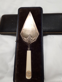
Ceremonial object - Object, Harrison Brothers & Howson, Ceremonial trowel
Sir Edward Mitchell was the chairman of the Edward Wilson trust, which enabled the building of the Braille Library during a time of great economic turbulence due to the last months of World War 1. This commemorative trowel was given to him in thanks for his (and the trust's support) of the project, which would ultimately provide a great resource to blinded soldiers who were prepared and able to learn Braille. In addition to the area housing the Braille collection itself, an entrance hall, reading room, secretarial office and hall also provided space for reading, administration of the collection and opportunities for social or recreational activities.1 silver plated trowel with handle inside boxPresented to Sir Edward Mitchell K.C., K.C.M.C. on the occasion of his laying the foundation stone of the new library for the Victorian Association of Braille Writers October 28th 1918. (Inside box lid: By Special Appointment Harrison Bros & Howson, Sheffield, England Cutlers to His Majesty)victorian association of braille writers, sir edward wilson