Showing 1133 items matching "kew east"
-
 Eltham District Historical Society Inc
Photograph, Looking north across the Fitzsimons Lane Bridge over Yarra River between Eltham and Templestowe, c.1985, 1985c
Turnoff to Candlebark Park on right. The bridge over the Yarra River was initially opened September 22nd, 1961. Newspaper reports at the time of opening stated it linked Bolton Street, Eltham, with Fitzsimons Lane, Templestowe. In 1955 the Country Roads Board (CRB) produced survey plans that showed proposed land acquisition for the future bridge and road approaches. The 1955 plan shows that it was proposed to connect Fitzsimons Lane with Bolton Street in Eltham by a diagonal road across the river. The road connection would then continue along Bolton Street to Main Road. Prior to construction of the bridge the CRB modified the proposal significantly so that there was a new road parallel with Bolton Street and then curving to join Main Road at what was then its intersection with Old Eltham Road. This involved significantly more land acquisition and altered the pattern of land subdivision through this corridor. Initially the new road was just a single two-way carriageway as it would have required a significant widening of the cutting on the Shire of Eltham side of the river. The road was officially un-named but was known locally as the Eltham-Templestowe Road. The 1966 Melway street directory and other 1960s editions also listed the road as the Eltham-Templestowe Road. In December 1970, Eltham Shire Council, in pursuance of the provisions of the Local Government Act, named it Templestowe Road. The road was renamed Fitzsimons Lane around 1984 in conformity with the section south of the river. In 1991 a new bridge was built to the west of the original bridge. Fitzsimons Lane was widened to four traffic lanes although on the Eltham side this was done within the limits of the existing cutting. NEW BRIDGE STARTS THEM EXPLORING Without any fanfares, Country Roads Board workmen on Friday afternoon put the finishing touches to the approaches, removed the barricades, and let the traffic roll over the new Yarra bridge linking Bolton Street, Eltham, with Fitzsimons Lane, Templestowe. Over the week-end many “bridge watchers” who were making one of their periodic inspections of the progress on the new bridge found to their surprise that they could drive over it, so that people who had gone for a run out to Eltham suddenly found themselves wandering through Templestowe and Doncaster. By Monday the word of the bridge’s opening had got around sufficiently for many regular travellers to the city from Eltham and beyond to vary the monotony by going to town via Templestowe and Kew instead of through Heidelberg. They were surprised at the distances – about 3 ½ miles from Eltham to Templestowe, 6 miles from Eltham Shire hall to the Lower Heidelberg Road-Banksia Street intersection. NEW NEIGHBOURS For people on both sides of the river, the new bridge has turned distant friends into near neighbours. A Greensborough man on Sunday took 35 minutes to reach the home of a friend in East Doncaster, but the return trip over the new bridge took only 17 minutes. It will be some time yet before most people work out the possibilities in shorter and quicker trips form the north-eastern areas to the eastern and south-eastern suburbs. The coming of the warmer months will soon teach many, though the short cuts to Peninsular beaches and eastern suburban drive-ins. And before very long it is likely there will be a Tramways bus running from Templestowe to Eltham station. NEW BRIDGE STARTS THEM EXPLORING (1961, September 27). The Diamond Valley News (News clipping held in SEA_74-1_047) The previously un-named road between Main Road and Yarra River, Eltham South, east of Bolton Street was named Templestowe Road, December 15, 1970 NAMING OF STREETS AND ROADS. (1970, December 15). The Diamond Valley News (News clipping held in SEA_74-2_022)Colour photographinfrastructure, shire of eltham infrastructure, bridge, fitzsimons lane bridge, yarra river, candlebark park, red nose day -
 Eltham District Historical Society Inc
Photograph, Fitzsimons Lane Bridge over Yarra River between Eltham and Templestowe
The bridge over the Yarra River was initially opened September 22nd, 1961. Newspaper reports at the time of opening stated it linked Bolton Street, Eltham, with Fitzsimons Lane, Templestowe. In 1955 the Country Roads Board (CRB) produced survey plans that showed proposed land acquisition for the future bridge and road approaches. The 1955 plan shows that it was proposed to connect Fitzsimons Lane with Bolton Street in Eltham by a diagonal road across the river. The road connection would then continue along Bolton Street to Main Road. Prior to construction of the bridge the CRB modified the proposal significantly so that there was a new road parallel with Bolton Street and then curving to join Main Road at what was then its intersection with Old Eltham Road. This involved significantly more land acquisition and altered the pattern of land subdivision through this corridor. Initially the new road was just a single two-way carriageway as it would have required a significant widening of the cutting on the Shire of Eltham side of the river. The road was officially un-named but was known locally as the Eltham-Templestowe Road. The 1966 Melway street directory and other 1960s editions also listed the road as the Eltham-Templestowe Road. In December 1970, Eltham Shire Council, in pursuance of the provisions of the Local Government Act, named it Templestowe Road. The road was renamed Fitzsimons Lane around 1984 in conformity with the section south of the river. In 1991 a new bridge was built to the west of the original bridge. Fitzsimons Lane was widened to four traffic lanes although on the Eltham side this was done within the limits of the existing cutting. NEW BRIDGE STARTS THEM EXPLORING Without any fanfares, Country Roads Board workmen on Friday afternoon put the finishing touches to the approaches, removed the barricades, and let the traffic roll over the new Yarra bridge linking Bolton Street, Eltham, with Fitzsimons Lane, Templestowe. Over the week-end many “bridge watchers” who were making one of their periodic inspections of the progress on the new bridge found to their surprise that they could drive over it, so that people who had gone for a run out to Eltham suddenly found themselves wandering through Templestowe and Doncaster. By Monday the word of the bridge’s opening had got around sufficiently for many regular travellers to the city from Eltham and beyond to vary the monotony by going to town via Templestowe and Kew instead of through Heidelberg. They were surprised at the distances – about 3 ½ miles from Eltham to Templestowe, 6 miles from Eltham Shire hall to the Lower Heidelberg Road-Banksia Street intersection. NEW NEIGHBOURS For people on both sides of the river, the new bridge has turned distant friends into near neighbours. A Greensborough man on Sunday took 35 minutes to reach the home of a friend in East Doncaster, but the return trip over the new bridge took only 17 minutes. It will be some time yet before most people work out the possibilities in shorter and quicker trips form the north-eastern areas to the eastern and south-eastern suburbs. The coming of the warmer months will soon teach many, though the short cuts to Peninsular beaches and eastern suburban drive-ins. And before very long it is likely there will be a Tramways bus running from Templestowe to Eltham station. NEW BRIDGE STARTS THEM EXPLORING (1961, September 27). The Diamond Valley News (News clipping held in SEA_74-1_047) The previously un-named road between Main Road and Yarra River, Eltham South, east of Bolton Street was named Templestowe Road, December 15, 1970 NAMING OF STREETS AND ROADS. (1970, December 15). The Diamond Valley News (News clipping held in SEA_74-2_022)Black and white photographinfrastructure, shire of eltham infrastructure, bridge, fitzsimons lane bridge, yarra river -
 Eltham District Historical Society Inc
Photograph, Looking south across the Fitzsimons Lane Bridge over Yarra River between Eltham and Templestowe
The bridge over the Yarra River was initially opened September 22nd, 1961. Newspaper reports at the time of opening stated it linked Bolton Street, Eltham, with Fitzsimons Lane, Templestowe. In 1955 the Country Roads Board (CRB) produced survey plans that showed proposed land acquisition for the future bridge and road approaches. The 1955 plan shows that it was proposed to connect Fitzsimons Lane with Bolton Street in Eltham by a diagonal road across the river. The road connection would then continue along Bolton Street to Main Road. Prior to construction of the bridge the CRB modified the proposal significantly so that there was a new road parallel with Bolton Street and then curving to join Main Road at what was then its intersection with Old Eltham Road. This involved significantly more land acquisition and altered the pattern of land subdivision through this corridor. Initially the new road was just a single two-way carriageway as it would have required a significant widening of the cutting on the Shire of Eltham side of the river. The road was officially un-named but was known locally as the Eltham-Templestowe Road. The 1966 Melway street directory and other 1960s editions also listed the road as the Eltham-Templestowe Road. In December 1970, Eltham Shire Council, in pursuance of the provisions of the Local Government Act, named it Templestowe Road. The road was renamed Fitzsimons Lane around 1984 in conformity with the section south of the river. In 1991 a new bridge was built to the west of the original bridge. Fitzsimons Lane was widened to four traffic lanes although on the Eltham side this was done within the limits of the existing cutting. NEW BRIDGE STARTS THEM EXPLORING Without any fanfares, Country Roads Board workmen on Friday afternoon put the finishing touches to the approaches, removed the barricades, and let the traffic roll over the new Yarra bridge linking Bolton Street, Eltham, with Fitzsimons Lane, Templestowe. Over the week-end many “bridge watchers” who were making one of their periodic inspections of the progress on the new bridge found to their surprise that they could drive over it, so that people who had gone for a run out to Eltham suddenly found themselves wandering through Templestowe and Doncaster. By Monday the word of the bridge’s opening had got around sufficiently for many regular travellers to the city from Eltham and beyond to vary the monotony by going to town via Templestowe and Kew instead of through Heidelberg. They were surprised at the distances – about 3 ½ miles from Eltham to Templestowe, 6 miles from Eltham Shire hall to the Lower Heidelberg Road-Banksia Street intersection. NEW NEIGHBOURS For people on both sides of the river, the new bridge has turned distant friends into near neighbours. A Greensborough man on Sunday took 35 minutes to reach the home of a friend in East Doncaster, but the return trip over the new bridge took only 17 minutes. It will be some time yet before most people work out the possibilities in shorter and quicker trips form the north-eastern areas to the eastern and south-eastern suburbs. The coming of the warmer months will soon teach many, though the short cuts to Peninsular beaches and eastern suburban drive-ins. And before very long it is likely there will be a Tramways bus running from Templestowe to Eltham station. NEW BRIDGE STARTS THEM EXPLORING (1961, September 27). The Diamond Valley News (News clipping held in SEA_74-1_047) The previously un-named road between Main Road and Yarra River, Eltham South, east of Bolton Street was named Templestowe Road, December 15, 1970 NAMING OF STREETS AND ROADS. (1970, December 15). The Diamond Valley News (News clipping held in SEA_74-2_022)Black and white photographinfrastructure, shire of eltham infrastructure, bridge, fitzsimons lane bridge, yarra river -
 Eltham District Historical Society Inc
Photograph, Fitzsimons Lane Bridge over Yarra River between Eltham and Templestowe
The bridge over the Yarra River was initially opened September 22nd, 1961. Newspaper reports at the time of opening stated it linked Bolton Street, Eltham, with Fitzsimons Lane, Templestowe. In 1955 the Country Roads Board (CRB) produced survey plans that showed proposed land acquisition for the future bridge and road approaches. The 1955 plan shows that it was proposed to connect Fitzsimons Lane with Bolton Street in Eltham by a diagonal road across the river. The road connection would then continue along Bolton Street to Main Road. Prior to construction of the bridge the CRB modified the proposal significantly so that there was a new road parallel with Bolton Street and then curving to join Main Road at what was then its intersection with Old Eltham Road. This involved significantly more land acquisition and altered the pattern of land subdivision through this corridor. Initially the new road was just a single two-way carriageway as it would have required a significant widening of the cutting on the Shire of Eltham side of the river. The road was officially un-named but was known locally as the Eltham-Templestowe Road. The 1966 Melway street directory and other 1960s editions also listed the road as the Eltham-Templestowe Road. In December 1970, Eltham Shire Council, in pursuance of the provisions of the Local Government Act, named it Templestowe Road. The road was renamed Fitzsimons Lane around 1984 in conformity with the section south of the river. In 1991 a new bridge was built to the west of the original bridge. Fitzsimons Lane was widened to four traffic lanes although on the Eltham side this was done within the limits of the existing cutting. NEW BRIDGE STARTS THEM EXPLORING Without any fanfares, Country Roads Board workmen on Friday afternoon put the finishing touches to the approaches, removed the barricades, and let the traffic roll over the new Yarra bridge linking Bolton Street, Eltham, with Fitzsimons Lane, Templestowe. Over the week-end many “bridge watchers” who were making one of their periodic inspections of the progress on the new bridge found to their surprise that they could drive over it, so that people who had gone for a run out to Eltham suddenly found themselves wandering through Templestowe and Doncaster. By Monday the word of the bridge’s opening had got around sufficiently for many regular travellers to the city from Eltham and beyond to vary the monotony by going to town via Templestowe and Kew instead of through Heidelberg. They were surprised at the distances – about 3 ½ miles from Eltham to Templestowe, 6 miles from Eltham Shire hall to the Lower Heidelberg Road-Banksia Street intersection. NEW NEIGHBOURS For people on both sides of the river, the new bridge has turned distant friends into near neighbours. A Greensborough man on Sunday took 35 minutes to reach the home of a friend in East Doncaster, but the return trip over the new bridge took only 17 minutes. It will be some time yet before most people work out the possibilities in shorter and quicker trips form the north-eastern areas to the eastern and south-eastern suburbs. The coming of the warmer months will soon teach many, though the short cuts to Peninsular beaches and eastern suburban drive-ins. And before very long it is likely there will be a Tramways bus running from Templestowe to Eltham station. NEW BRIDGE STARTS THEM EXPLORING (1961, September 27). The Diamond Valley News (News clipping held in SEA_74-1_047) The previously un-named road between Main Road and Yarra River, Eltham South, east of Bolton Street was named Templestowe Road, December 15, 1970 NAMING OF STREETS AND ROADS. (1970, December 15). The Diamond Valley News (News clipping held in SEA_74-2_022)Black and white photographinfrastructure, shire of eltham infrastructure, bridge, fitzsimons lane bridge, yarra river -
 Eltham District Historical Society Inc
Photograph, Russell Yeoman, Fitzsimons Lane Bridge over Yarra River between Eltham and Templestowe, c.1970, 1970c
The bridge over the Yarra River was initially opened September 22nd, 1961. Newspaper reports at the time of opening stated it linked Bolton Street, Eltham, with Fitzsimons Lane, Templestowe. In 1955 the Country Roads Board (CRB) produced survey plans that showed proposed land acquisition for the future bridge and road approaches. The 1955 plan shows that it was proposed to connect Fitzsimons Lane with Bolton Street in Eltham by a diagonal road across the river. The road connection would then continue along Bolton Street to Main Road. Prior to construction of the bridge the CRB modified the proposal significantly so that there was a new road parallel with Bolton Street and then curving to join Main Road at what was then its intersection with Old Eltham Road. This involved significantly more land acquisition and altered the pattern of land subdivision through this corridor. Initially the new road was just a single two-way carriageway as it would have required a significant widening of the cutting on the Shire of Eltham side of the river. The road was officially un-named but was known locally as the Eltham-Templestowe Road. The 1966 Melway street directory and other 1960s editions also listed the road as the Eltham-Templestowe Road. In December 1970, Eltham Shire Council, in pursuance of the provisions of the Local Government Act, named it Templestowe Road. The road was renamed Fitzsimons Lane around 1984 in conformity with the section south of the river. In 1991 a new bridge was built to the west of the original bridge. Fitzsimons Lane was widened to four traffic lanes although on the Eltham side this was done within the limits of the existing cutting. NEW BRIDGE STARTS THEM EXPLORING Without any fanfares, Country Roads Board workmen on Friday afternoon put the finishing touches to the approaches, removed the barricades, and let the traffic roll over the new Yarra bridge linking Bolton Street, Eltham, with Fitzsimons Lane, Templestowe. Over the week-end many “bridge watchers” who were making one of their periodic inspections of the progress on the new bridge found to their surprise that they could drive over it, so that people who had gone for a run out to Eltham suddenly found themselves wandering through Templestowe and Doncaster. By Monday the word of the bridge’s opening had got around sufficiently for many regular travellers to the city from Eltham and beyond to vary the monotony by going to town via Templestowe and Kew instead of through Heidelberg. They were surprised at the distances – about 3 ½ miles from Eltham to Templestowe, 6 miles from Eltham Shire hall to the Lower Heidelberg Road-Banksia Street intersection. NEW NEIGHBOURS For people on both sides of the river, the new bridge has turned distant friends into near neighbours. A Greensborough man on Sunday took 35 minutes to reach the home of a friend in East Doncaster, but the return trip over the new bridge took only 17 minutes. It will be some time yet before most people work out the possibilities in shorter and quicker trips form the north-eastern areas to the eastern and south-eastern suburbs. The coming of the warmer months will soon teach many, though the short cuts to Peninsular beaches and eastern suburban drive-ins. And before very long it is likely there will be a Tramways bus running from Templestowe to Eltham station. NEW BRIDGE STARTS THEM EXPLORING (1961, September 27). The Diamond Valley News (News clipping held in SEA_74-1_047) The previously un-named road between Main Road and Yarra River, Eltham South, east of Bolton Street was named Templestowe Road, December 15, 1970 NAMING OF STREETS AND ROADS. (1970, December 15). The Diamond Valley News (News clipping held in SEA_74-2_022)Roll of 35mm black and white negative film, 4 of 7 stripsIlford HP4bridge, bridges, fitzsimons lane bridge, infrastructure, shire of eltham infrastructure, yarra river -
 Eltham District Historical Society Inc
Photograph, Fitzsimons Lane Bridge over Yarra River between Eltham and Templestowe, c.1966, 1966c
The bridge over the Yarra River was initially opened September 22nd, 1961. Newspaper reports at the time of opening stated it linked Bolton Street, Eltham, with Fitzsimons Lane, Templestowe. In 1955 the Country Roads Board (CRB) produced survey plans that showed proposed land acquisition for the future bridge and road approaches. The 1955 plan shows that it was proposed to connect Fitzsimons Lane with Bolton Street in Eltham by a diagonal road across the river. The road connection would then continue along Bolton Street to Main Road. Prior to construction of the bridge the CRB modified the proposal significantly so that there was a new road parallel with Bolton Street and then curving to join Main Road at what was then its intersection with Old Eltham Road. This involved significantly more land acquisition and altered the pattern of land subdivision through this corridor. Initially the new road was just a single two-way carriageway as it would have required a significant widening of the cutting on the Shire of Eltham side of the river. The road was officially un-named but was known locally as the Eltham-Templestowe Road. The 1966 Melway street directory and other 1960s editions also listed the road as the Eltham-Templestowe Road. In December 1970, Eltham Shire Council, in pursuance of the provisions of the Local Government Act, named it Templestowe Road. The road was renamed Fitzsimons Lane around 1984 in conformity with the section south of the river. In 1991 a new bridge was built to the west of the original bridge. Fitzsimons Lane was widened to four traffic lanes although on the Eltham side this was done within the limits of the existing cutting. NEW BRIDGE STARTS THEM EXPLORING Without any fanfares, Country Roads Board workmen on Friday afternoon put the finishing touches to the approaches, removed the barricades, and let the traffic roll over the new Yarra bridge linking Bolton Street, Eltham, with Fitzsimons Lane, Templestowe. Over the week-end many “bridge watchers” who were making one of their periodic inspections of the progress on the new bridge found to their surprise that they could drive over it, so that people who had gone for a run out to Eltham suddenly found themselves wandering through Templestowe and Doncaster. By Monday the word of the bridge’s opening had got around sufficiently for many regular travellers to the city from Eltham and beyond to vary the monotony by going to town via Templestowe and Kew instead of through Heidelberg. They were surprised at the distances – about 3 ½ miles from Eltham to Templestowe, 6 miles from Eltham Shire hall to the Lower Heidelberg Road-Banksia Street intersection. NEW NEIGHBOURS For people on both sides of the river, the new bridge has turned distant friends into near neighbours. A Greensborough man on Sunday took 35 minutes to reach the home of a friend in East Doncaster, but the return trip over the new bridge took only 17 minutes. It will be some time yet before most people work out the possibilities in shorter and quicker trips form the north-eastern areas to the eastern and south-eastern suburbs. The coming of the warmer months will soon teach many, though the short cuts to Peninsular beaches and eastern suburban drive-ins. And before very long it is likely there will be a Tramways bus running from Templestowe to Eltham station. NEW BRIDGE STARTS THEM EXPLORING (1961, September 27). The Diamond Valley News (News clipping held in SEA_74-1_047) The previously un-named road between Main Road and Yarra River, Eltham South, east of Bolton Street was named Templestowe Road, December 15, 1970 NAMING OF STREETS AND ROADS. (1970, December 15). The Diamond Valley News (News clipping held in SEA_74-2_022)Black and white photographManufacturer's marks: Polaroid, Batch #J62K181 (Sep 1966).infrastructure, shire of eltham infrastructure, bridge, fitzsimons lane bridge, polaroid, yarra river -
 Eltham District Historical Society Inc
Photograph, Fitzsimons Lane Bridge over Yarra River between Eltham and Templestowe
The bridge over the Yarra River was initially opened September 22nd, 1961. Newspaper reports at the time of opening stated it linked Bolton Street, Eltham, with Fitzsimons Lane, Templestowe. In 1955 the Country Roads Board (CRB) produced survey plans that showed proposed land acquisition for the future bridge and road approaches. The 1955 plan shows that it was proposed to connect Fitzsimons Lane with Bolton Street in Eltham by a diagonal road across the river. The road connection would then continue along Bolton Street to Main Road. Prior to construction of the bridge the CRB modified the proposal significantly so that there was a new road parallel with Bolton Street and then curving to join Main Road at what was then its intersection with Old Eltham Road. This involved significantly more land acquisition and altered the pattern of land subdivision through this corridor. Initially the new road was just a single two-way carriageway as it would have required a significant widening of the cutting on the Shire of Eltham side of the river. The road was officially un-named but was known locally as the Eltham-Templestowe Road. The 1966 Melway street directory and other 1960s editions also listed the road as the Eltham-Templestowe Road. In December 1970, Eltham Shire Council, in pursuance of the provisions of the Local Government Act, named it Templestowe Road. The road was renamed Fitzsimons Lane around 1984 in conformity with the section south of the river. In 1991 a new bridge was built to the west of the original bridge. Fitzsimons Lane was widened to four traffic lanes although on the Eltham side this was done within the limits of the existing cutting. NEW BRIDGE STARTS THEM EXPLORING Without any fanfares, Country Roads Board workmen on Friday afternoon put the finishing touches to the approaches, removed the barricades, and let the traffic roll over the new Yarra bridge linking Bolton Street, Eltham, with Fitzsimons Lane, Templestowe. Over the week-end many “bridge watchers” who were making one of their periodic inspections of the progress on the new bridge found to their surprise that they could drive over it, so that people who had gone for a run out to Eltham suddenly found themselves wandering through Templestowe and Doncaster. By Monday the word of the bridge’s opening had got around sufficiently for many regular travellers to the city from Eltham and beyond to vary the monotony by going to town via Templestowe and Kew instead of through Heidelberg. They were surprised at the distances – about 3 ½ miles from Eltham to Templestowe, 6 miles from Eltham Shire hall to the Lower Heidelberg Road-Banksia Street intersection. NEW NEIGHBOURS For people on both sides of the river, the new bridge has turned distant friends into near neighbours. A Greensborough man on Sunday took 35 minutes to reach the home of a friend in East Doncaster, but the return trip over the new bridge took only 17 minutes. It will be some time yet before most people work out the possibilities in shorter and quicker trips form the north-eastern areas to the eastern and south-eastern suburbs. The coming of the warmer months will soon teach many, though the short cuts to Peninsular beaches and eastern suburban drive-ins. And before very long it is likely there will be a Tramways bus running from Templestowe to Eltham station. NEW BRIDGE STARTS THEM EXPLORING (1961, September 27). The Diamond Valley News (News clipping held in SEA_74-1_047) The previously un-named road between Main Road and Yarra River, Eltham South, east of Bolton Street was named Templestowe Road, December 15, 1970 NAMING OF STREETS AND ROADS. (1970, December 15). The Diamond Valley News (News clipping held in SEA_74-2_022)Black and white photographinfrastructure, shire of eltham infrastructure, bridge, fitzsimons lane bridge, yarra river -
 Eltham District Historical Society Inc
Photograph, Fitzsimons Lane Bridge over Yarra River between Eltham and Templestowe
The bridge over the Yarra River was initially opened September 22nd, 1961. Newspaper reports at the time of opening stated it linked Bolton Street, Eltham, with Fitzsimons Lane, Templestowe. In 1955 the Country Roads Board (CRB) produced survey plans that showed proposed land acquisition for the future bridge and road approaches. The 1955 plan shows that it was proposed to connect Fitzsimons Lane with Bolton Street in Eltham by a diagonal road across the river. The road connection would then continue along Bolton Street to Main Road. Prior to construction of the bridge the CRB modified the proposal significantly so that there was a new road parallel with Bolton Street and then curving to join Main Road at what was then its intersection with Old Eltham Road. This involved significantly more land acquisition and altered the pattern of land subdivision through this corridor. Initially the new road was just a single two-way carriageway as it would have required a significant widening of the cutting on the Shire of Eltham side of the river. The road was officially un-named but was known locally as the Eltham-Templestowe Road. The 1966 Melway street directory and other 1960s editions also listed the road as the Eltham-Templestowe Road. In December 1970, Eltham Shire Council, in pursuance of the provisions of the Local Government Act, named it Templestowe Road. The road was renamed Fitzsimons Lane around 1984 in conformity with the section south of the river. In 1991 a new bridge was built to the west of the original bridge. Fitzsimons Lane was widened to four traffic lanes although on the Eltham side this was done within the limits of the existing cutting. NEW BRIDGE STARTS THEM EXPLORING Without any fanfares, Country Roads Board workmen on Friday afternoon put the finishing touches to the approaches, removed the barricades, and let the traffic roll over the new Yarra bridge linking Bolton Street, Eltham, with Fitzsimons Lane, Templestowe. Over the week-end many “bridge watchers” who were making one of their periodic inspections of the progress on the new bridge found to their surprise that they could drive over it, so that people who had gone for a run out to Eltham suddenly found themselves wandering through Templestowe and Doncaster. By Monday the word of the bridge’s opening had got around sufficiently for many regular travellers to the city from Eltham and beyond to vary the monotony by going to town via Templestowe and Kew instead of through Heidelberg. They were surprised at the distances – about 3 ½ miles from Eltham to Templestowe, 6 miles from Eltham Shire hall to the Lower Heidelberg Road-Banksia Street intersection. NEW NEIGHBOURS For people on both sides of the river, the new bridge has turned distant friends into near neighbours. A Greensborough man on Sunday took 35 minutes to reach the home of a friend in East Doncaster, but the return trip over the new bridge took only 17 minutes. It will be some time yet before most people work out the possibilities in shorter and quicker trips form the north-eastern areas to the eastern and south-eastern suburbs. The coming of the warmer months will soon teach many, though the short cuts to Peninsular beaches and eastern suburban drive-ins. And before very long it is likely there will be a Tramways bus running from Templestowe to Eltham station. NEW BRIDGE STARTS THEM EXPLORING (1961, September 27). The Diamond Valley News (News clipping held in SEA_74-1_047) The previously un-named road between Main Road and Yarra River, Eltham South, east of Bolton Street was named Templestowe Road, December 15, 1970 NAMING OF STREETS AND ROADS. (1970, December 15). The Diamond Valley News (News clipping held in SEA_74-2_022)Black and white photographinfrastructure, shire of eltham infrastructure, bridge, fitzsimons lane bridge, yarra river -
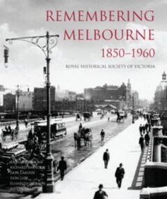 Camberwell Historical Society
Book, Royal Historical Society of Victoria, Remembering Melbourne 1850-1960, 2016
History of the city of Melbourne and selected suburbs (Brighton, Brunswick, Camberwell, Hawthorn, Balwyn, Canterbury, Carlton, Coburg, Collingwood, East Melbourne, Essendon, Fitzroy, Footscray, Heidelberg, Kew, Malvern, Middle Park, North Melbourne, West Melbourne, Port Melbourne, Richmond, Sunshine, Surrey Hills).Book featuring text and over 700 black and white illustrations of buildings that have been demolished or changed significantly across 20 suburbs, capturing the early city of Melbourne. Published by the RHSV. History of the city of Melbourne and selected suburbs (Brighton, Brunswick, Camberwell, Hawthorn, Balwyn, Canterbury, Carlton, Coburg, Collingwood, East Melbourne, Essendon, Fitzroy, Footscray, Heidelberg, Kew, Malvern, Middle Park, North Melbourne, West Melbourne, Port Melbourne, Richmond, Sunshine, Surrey Hills).camberwell, melbourne -
 Ballarat Heritage Services
Photograph, Sacred Heart Mercy Convent, Victoria Street, Ballarat East
In 1872 members of the Jesuits purchased land in Walpole Street. Three years later, on 14 February 1875, Archbishop Gould laid a foundation stone for a school. By 1899 the land for the current church was purchased after mining speculator and Mt Lyell 'Copper King' James Crotty donated 3,000.00 pounds. The foundation stone was laid on 15 December 1918 by Archbishop Mannix. The cost of constructing the domed church was 15,000.00 pounds. A Fincham and Sons organ was installed in 1927, and refurbished in 1977. NEW PRESBYTERY AT KEW. Plans have been prepared by Mr. R. Harper, architect and builder, for the erection of a new presbytery for the Rev. P. Rafferty, adjoining the Sacred Heart Church, Cotham-road, Kew. The new building, which will be in brick and of two stories, will be behind the present priests' residence, which will continue to be used until the new presbytery is completed. The cost will be £6000, and the work will be begun almost immediately. The old presbytery was purchased many years ago by the late Rev. Fr. P. O'Donohue from the late Mr. Smart for £3000, and the full amount of the purchase money was donated by the late Mr. James Crotty. At different times additions were made to the building, but the small rooms made it altogether unsuitable as a residence for three priests, and made remodelling impracticable. The new presbytery will be in keeping with the Church of the Sacred Heart and the surroundings on the elevated site. At one time the old Sacred Heart Church was in Walpole-street, Kew. (The Advocate, 09 December 1937) The whole of the estate of the late Jas. Crotty has now been realised ex cepting 4000 shares in the Mount Lyell Company and a small parcel of general mining shares. All the debts and legacies, including £10,000 to St. Patrick's and £3300 to the testator's parish church at Kew, and also probate duty, have been paid. On present values the Mount Lyell shares. are worth a total of £37,000, and at the present rate of dividends the return represents an income of about £2000 per annum. Over and above this there is a sum of between £20,000 and £30,000 available for investment, and this, together with the dividends brings the income of the estate up to about £3000 per annum. A sum of £1100 per annum will be absorbed in annuities under the terms of the will. Whatever amount is realised beyond the sum necessary to pay the annuities goes to Archbishop Carr for the church and charitable purposes until the death of the last annuitant, when the resi duary estate will be divided between the Little Sisters of the Poor (North cote) and St. Joseph's Home (Surrey Hills). (Launceston Examiner, 18 July 1899) Sunday last being the anniversary of tire opening of the Sacred Heart Church, Kew, the pastor, Rev. Fr. Manly, made a special appeal at the various Masses. The beautiful design for marble altar for the Lady Chapel, which is on view in the vestibule, continues to attract attention. The Children of Mary Sodality have kindly undertaken to provide it, and the president, Miss Frances O'Sulliv!an, 43 Rideway-avenue, Kew, will be pleased to receive and acknowledge subscriptions from clients of Our Lady. They may also be placed in box near Lady Altar. (The Advocate, 06 December 1923) Number of photographes of the entrance to Sacred Heart Mercy Convent, Victoria Street, Ballarat East, as well as stained glass windows in the chapel.sacred heart mercy convent, ballarat east, stained glass window, sacred heart of jesus, john hove, announciation, kathleen blanche meagan, sacred heart college -
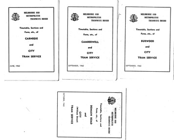 Melbourne Tram Museum
Ephemera - Timetable, Melbourne & Metropolitan Tramways Board (MMTB), Set of 30 MMTB tram timetables, 1962
Demonstrates a set of MMTB 1962 timetables.Set of 30 MMTB tram timetables, folded sheets, 4 fold, providing timetables for specific routes, day of week giving information on tram times at the terminus, sections and fares, running times. Some signed by W. J. Richards as Acting Traffic Manager, or R. C. Drummond as Traffic Manager. Route Numbers not given on cover, generally given on inside. Where a All night service was applicable, shown as well. .1 - Burwood - City - 9/1962 .2 - Camberwell - City - 9/1962 .3 - Carnegie - City - 6/1962 .4 - Domain Rd - City - 10/1962 .5 - East Brighton - City - 6/1962 .6 - East Coburg - city - 9/1962 .7 - East Malvern - Darling Rd - City 27/5/1962 .8 - East Preston - City - 11/1962 .9 - Essendon Aerodrome - City - July 1962 .10 - Essendon (Matthews Ave) - City - 7/1962 .11 - Glen Iris - City - 8/1962 .12 - Hawthorn - Spencer St - 7/1962 .13 - Kew Cotham Rd - St Kilda Beach - 8/1962 .14 - Malvern Burke Rd - City - 8/1962 .15 - Mont Albert - City - 7/1962 .16 - Moreland - City - 9/1962 .17 - West Coburg - City 7/1962. .18 - North Balwyn - Spencer St - 7/1962 .19 - North Coburg - City - 6/1962 - has Sunday only Fawkner Railway station service on rear - 6/1962 .20 - North Richmond - Prahran and St Kilda Beach - 7/1962 .21 - Northcote (via St Georges Rd) - City - 7/1962 .22 - Prahran - City - 7/1962 .23 - South Melbourne and St Kilda Beach - City - 6/1962 .24 - St Kilda Beach - City - - 9/1962 .25 - Toorak - City - 8/1962 .26 - Wattle Park - Elgar Rd - City - 9/1962 .27 - West Maribyrnong - City - 7/1962 .28 - West Preston - City - 6/1962 .29 - West Coburg - City - 10/1962 ,30 - East Preston - City - 7/1962Some have "Robert Wilson" stamp on the covers.trams, tramways, timetables, tickets, fares, mmtb, all night services -
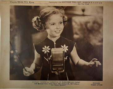 Kew Historical Society Inc
Ephemera - Hoyts Rialto Kew, Shirley Temple in Rebecca of Sunnybrook Farm
... Located in the east Melbourne district of Kew. The Rialto...Located in the east Melbourne district of Kew. The Rialto ...Located in the east Melbourne district of Kew. The Rialto Theatre was opened on 31st August 1921 with Bert Lytell in “A Message From Mars”. It was taken over by Hoyts Theatres in 1926. It was closed on 17th May 1961.Four-page playbill produced by Hoyts Rialto Cinema in Kew for a feature film starring Deanna Durban in That Certain Age. The matinee also included serials of A Trip to Mars, Wild Bill Hickock, and The Lyin' Tamer.rialto cinema kew, hoyts theatres -- melbourne (vic.), that certain age -
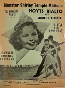 Kew Historical Society Inc
Ephemera - Hoyts Rialto Kew, Little Miss Broadway
... Located in the east Melbourne district of Kew. The Rialto...Located in the east Melbourne district of Kew. The Rialto ...Located in the east Melbourne district of Kew. The Rialto Theatre was opened on 31st August 1921 with Bert Lytell in “A Message From Mars”. It was taken over by Hoyts Theatres in 1926. It was closed on 17th May 1961.Single-side playbill produced by Hoyts Rialto Cinema in Kew for a feature film starring Shirley Temple: Little Miss Broadway. The matinee also included a newsreel, comedies and cartoons.rialto cinema kew, hoyts theatres -- melbourne (vic.) -
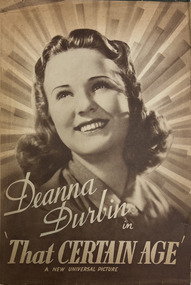 Kew Historical Society Inc
Ephemera - Hoyts Rialto Kew, Deanna Durban in That Certain Age
... Located in the east Melbourne district of Kew. The Rialto...Located in the east Melbourne district of Kew. The Rialto ...Located in the east Melbourne district of Kew. The Rialto Theatre was opened on 31st August 1921 with Bert Lytell in “A Message From Mars”. It was taken over by Hoyts Theatres in 1926. It was closed on 17th May 1961.Four-page playbill produced by Hoyts Rialto Cinema in Kew for a feature film starring Deanna Durban in That Certain Age. The matinee also included serials of A Trip to Mars, Wild Bill Hickock, and The Lyin' Tamer.rialto cinema kew, hoyts theatres -- melbourne (vic.), that certain age -
 Melbourne Tram Museum
Document - Notice, Met Tram, 'Port Melbourne Y Junction", 14/11/1994
Document issued drivers at Kew and South Melbourne depots 14/11/1994 concerning the right of way for trams at the 'Port Melbourne Y Junction" - all trams to stop at the compulsory stops and Port Melbourne trams must give right of way to St Kilda Beach LRVs. Signed by Alan East, Manager Operations Support, Met Tram.Demonstrates instructions issued re the operation of the Port Melbourne Y junction or Port Junction.Document - 1 A4 pages photocopied fax message.tramways, port melbourne, st kilda light rail, drivers, notice, instruction -
 Kew Historical Society Inc
Clothing - Evening Coat, 1920–1930
The donor, whose parents owned an antique shop believed that the evening coat was owned by the family of Cr Morris Nathan and his wife Margaret Frances, nee MacKay. Maurice Nathan was born in Kew in 1914 and died in East Melbourne in 1982. He was a student of Trinity Grammar School, Kew. He was Lord Mayor, and his wife Lady Mayoress, of the City of Melbourne for two terms between 1961 and 1963. The age of the coat, created in a design typical of the 1920s would suggest that it is of an earlier vintage, almost certainly dating from the 1920s, but perhaps earlier. The opulence of the sequinned and beaded embroidery have led to the supposition that it may be an opera coat inherited from an earlier generation.Three quarter length, red and cream silk, padded evening coat highlighted on the cuffs and hem with iridescent sequins, beading and pearls of different shapes and sizes. These decorative features are arranged in a formal design, particularly at centre back. Above the beaded sections are sunbursts outlined in gold beads.Trimmed rabbit fur at collar and cuffs. The sleeves are shaped above the embroidered sections while the hem features a zig-zag profile. MEASUREMENTS - Neck to hem front 93cm; Neck to hem back 100cm; Circumference 126cm; Shoulder to cuff 72cm; Shoulder width 36cm.Traditionally, pre acquisition, stored in brown suitcase embossed in gilt with the name R. NATHANevening jackets, opera coats, fashion -- 1920s -
 Ballarat Heritage Services
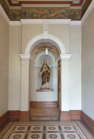
Photograph - Digital photographs, L.J. Gervasoni, Xavier College Chapel, c2016, c2016
Xavier College was first opened by the Society of Jesus (the Jesuits) in 1878. It belongs to a worldwide network of over 2,000 Jesuit educational institutions. The original Senior Campus location on Barkers Road, Kew is a culmination of modern innovation and rich historical preservation. The land on which Xavier stands was known as Mornane’s Paddock and was purchased by the Jesuits in 1872 from Patrick Mornane on a 20-year interest-free purchase plan. This enabled the Jesuits to get on with the funding and building of the College buildings almost immediately. Foundations for the South Wing commenced in 1872, with the front of the building completed in time for classes to begin in 1878. Many of the first boarders transferred from St Patrick’s College in East Melbourne. With the closure of St Patrick’s years later, many students, associated lay staff and Jesuits also transferred to Xavier College. Over the following century, Xavier College grew with two junior campuses; Burke Hall Campus and Kostka Hall Campus. In recent years, extensive refurbishments, renovations and improvements have moulded the properties into the beautiful sites they are today. In 2002 at our Burke Hall campus and in 2005 at our Kostka Hall campus, the College expanded its educational program, opening Early Years centres to provide the scope for a Jesuit education from the earliest ages. For the first time in the College’s history, girls were admitted to the Early Years, breaking the long-standing tradition of Xavier being a boys-only school. In 2021, after 85 years of inspiring education experiences, our Kostka Hall campus closed its gates for the final time. In 1920, Archbishop Daniel Mannix donated the house and land known as Studley Hall to Xavier College for use as a preparatory school. The property had been purchased and donated to Mannix by Mr T.M. Burke, a Catholic businessman. In 1921, Xavier Preparatory School opened and was later renamed Burke Hall in 1926 in honour of Mr Burke. The Kostka Hall location was opened in 1937 and was named in honour of St Stanislaus Kostka. To establish the second preparatory school, the Jesuits purchased two Brighton properties in mid-1936. Both were promptly remodelled to provide the facilities required for school life. (https://xavier.vic.edu.au/xavier-history, accessed 15/05/2025) Colour photograph of the section of the Chapel at Xavier College, Kew, Victoria. heritage, kew, xavier college, chapel, catholic, st francis xavier, xavier chapel -
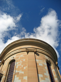
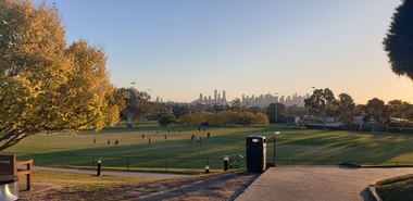 Ballarat Heritage Services
Photograph - Digital photographs, Clare Gervasoni, Melbourne Views from Xavier College Chapel, 2025, 05/2025
Xavier College was first opened by the Society of Jesus (the Jesuits) in 1878. It belongs to a worldwide network of over 2,000 Jesuit educational institutions. The original Senior Campus location on Barkers Road, Kew is a culmination of modern innovation and rich historical preservation. The land on which Xavier stands was known as Mornane’s Paddock and was purchased by the Jesuits in 1872 from Patrick Mornane on a 20-year interest-free purchase plan. This enabled the Jesuits to get on with the funding and building of the College buildings almost immediately. Foundations for the South Wing commenced in 1872, with the front of the building completed in time for classes to begin in 1878. Many of the first boarders transferred from St Patrick’s College in East Melbourne. With the closure of St Patrick’s years later, many students, associated lay staff and Jesuits also transferred to Xavier College. Over the following century, Xavier College grew with two junior campuses; Burke Hall Campus and Kostka Hall Campus. In recent years, extensive refurbishments, renovations and improvements have moulded the properties into the beautiful sites they are today. In 2002 at our Burke Hall campus and in 2005 at our Kostka Hall campus, the College expanded its educational program, opening Early Years centres to provide the scope for a Jesuit education from the earliest ages. For the first time in the College’s history, girls were admitted to the Early Years, breaking the long-standing tradition of Xavier being a boys-only school. In 2021, after 85 years of inspiring education experiences, our Kostka Hall campus closed its gates for the final time. In 1920, Archbishop Daniel Mannix donated the house and land known as Studley Hall to Xavier College for use as a preparatory school. The property had been purchased and donated to Mannix by Mr T.M. Burke, a Catholic businessman. In 1921, Xavier Preparatory School opened and was later renamed Burke Hall in 1926 in honour of Mr Burke. The Kostka Hall location was opened in 1937 and was named in honour of St Stanislaus Kostka. To establish the second preparatory school, the Jesuits purchased two Brighton properties in mid-1936. Both were promptly remodelled to provide the facilities required for school life. (https://xavier.vic.edu.au/xavier-history, accessed 15/05/2025) Colour photograph of the Melbourne highrise from the Chapel at Xavier College, Kew, Victoria. heritage, kew, xavier college, chapel, catholic, st francis xavier, xavier chapel -
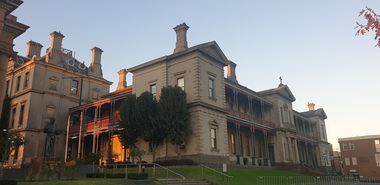 Ballarat Heritage Services
Photograph - Digital photographs, Clare Gervasoni, Exterior Views of Xavier College, 2025, 05/2025
Xavier College was first opened by the Society of Jesus (the Jesuits) in 1878. It belongs to a worldwide network of over 2,000 Jesuit educational institutions. The original Senior Campus location on Barkers Road, Kew is a culmination of modern innovation and rich historical preservation. The land on which Xavier stands was known as Mornane’s Paddock and was purchased by the Jesuits in 1872 from Patrick Mornane on a 20-year interest-free purchase plan. This enabled the Jesuits to get on with the funding and building of the College buildings almost immediately. Foundations for the South Wing commenced in 1872, with the front of the building completed in time for classes to begin in 1878. Many of the first boarders transferred from St Patrick’s College in East Melbourne. With the closure of St Patrick’s years later, many students, associated lay staff and Jesuits also transferred to Xavier College. Over the following century, Xavier College grew with two junior campuses; Burke Hall Campus and Kostka Hall Campus. In recent years, extensive refurbishments, renovations and improvements have moulded the properties into the beautiful sites they are today. In 2002 at our Burke Hall campus and in 2005 at our Kostka Hall campus, the College expanded its educational program, opening Early Years centres to provide the scope for a Jesuit education from the earliest ages. For the first time in the College’s history, girls were admitted to the Early Years, breaking the long-standing tradition of Xavier being a boys-only school. In 2021, after 85 years of inspiring education experiences, our Kostka Hall campus closed its gates for the final time. In 1920, Archbishop Daniel Mannix donated the house and land known as Studley Hall to Xavier College for use as a preparatory school. The property had been purchased and donated to Mannix by Mr T.M. Burke, a Catholic businessman. In 1921, Xavier Preparatory School opened and was later renamed Burke Hall in 1926 in honour of Mr Burke. The Kostka Hall location was opened in 1937 and was named in honour of St Stanislaus Kostka. To establish the second preparatory school, the Jesuits purchased two Brighton properties in mid-1936. Both were promptly remodelled to provide the facilities required for school life. (https://xavier.vic.edu.au/xavier-history, accessed 15/05/2025) Colour photograph of the buildings and Chapel at Xavier College, Kew, Victoria. heritage, kew, xavier college, chapel, catholic, st francis xavier, xavier chapel