Showing 4573 items
matching park street
-
 Eltham District Historical Society Inc
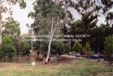
Photograph, Flooding of Diamond Creek at Lower Eltham, Feb 2005, 2005
... melbourne eltham main road diamond creek floods dalton street ...Three colour photographs of the flooded Diamond Creek showing Main Road floodwater below Dalton Street (Eltham Primary) school, west side of Diamond Creek near flower stall and Wingrove Park, Feb 2005eltham, main road, diamond creek, floods, dalton street, wingrove park -
 Eltham District Historical Society Inc
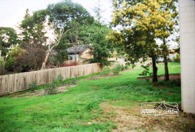
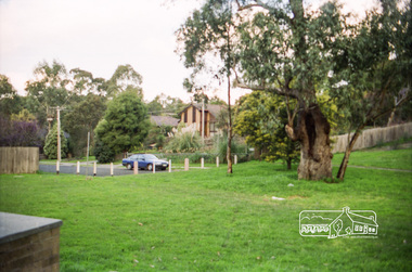
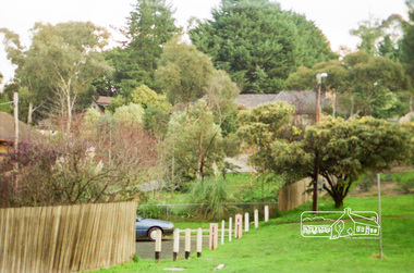
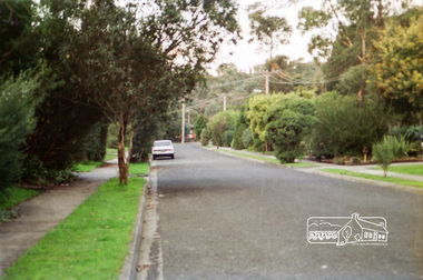
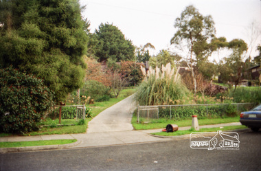
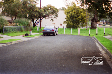
Photograph, Looking towards No. 2 Robert Street from Petrie Park, Montmorency
... Looking towards No. 2 Robert Street from Petrie Park... melbourne streetscape robert street montmorency petrie park Kodak GA ...Roll of 35mm colour negative film, 7 stripsKodak GA 100 5095streetscape, robert street, montmorency, petrie park -
 Eltham District Historical Society Inc
Photograph, Betty Lynch (left), Russell and Marion Yeoman at the Everard Memorial, Mt Everard, Kinglake National Park, c.April, 2004, 2004
Betty Lynch OAM, daughter of William Everard and sister of Blanche Shallard This photo appears to have been taken at a later date to the dedication ceremony of 22 April.This lockup used to be located at the Police Station in Pryor Street and was then stored in Youth Road before being acquired for the Local History Centre Colour photographbetty lynch, everard memorial, mt everard, kinglake national park, blanche shallard -
 Eltham District Historical Society Inc
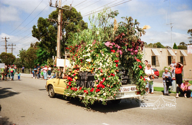
Photograph, Eltham Festival Parade, 11 November 1989; Main Road near the corner with Arthur Street, 11/11/1989
Featuring various community group floats and participation. Also Society member, Jock Read riding his horse, LoftyRoll of 35mm colour negative film, 6 stripsFuji 100 Neltham, main road, eltham central park, eltham festival, parade, shire of eltham historical society, parade float, jock read -
 Eltham District Historical Society Inc
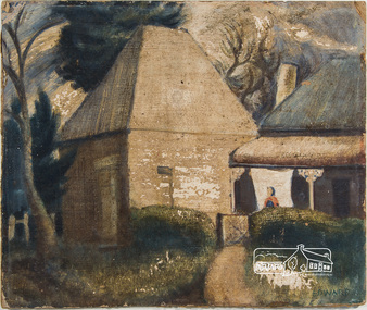
Painting, Lindsay Edward, The Malt House, 1942c
Artist Lindsay Edward and wife Jan built a house designed by Alistair Knox at 151 Old Eltham Road, Lower Plenty. See article on home designed by Alistair Knox for Lindsay Edward, teacher, at 151 Old Eltham Road, Lower Plenty. The home was originally featured on the cover of the January 1953 issue of Home Beautiful magazine and was revisited in the March 1969 issue. See registration record No. 01649. Lindsay Edward Biography: 1919: 26 August Lindsay Maurice Edward was born in Melbourne. 1937: 4 – 9 May Exhibition - Heidelberg art exhibition (SLV collection) 1939: Art student at the National Gallery of Victoria 1940: 7-14 October Exhibition Heidelberg art exhibition. (SLV collection) 1941: November - Exhibition Heidelberg Art Exhibition 1942: Lindsay was an art student living at this 14 Park Cres. Fairfield. Occupation Art student. He most likely painted this painting around this time. c.1942 – 1944: Enlistment for military service in World War 2 in Casino, NSW. 1944: Rank of Sergeant. 1944: Exhibition Seddon Galleries (Melbourne) 1945: Exhibition Seddon Galleries 1946: Exhibition Exhibition of Past Students of the National Gallery of Victoria 1947: Submitted “Self- portrait in the Archibald Prize, Art Gallery of NSW 1948: Lived in London for a year and married a fellow artist ? Knox. 1949: Returned from London 1949: Electoral Roll Residence– 16 Mount Street, Ivanhoe 1950: October Exhibition Stanley Coe Galleries, 435 Bourke Street, Melbourne 1951: 19 Nov. - 9 Dec. Exhibition An exhibition of present day art of Victoria Victorian 1951 Commemoration Committee in conjunction with the Victorian Artists' Society, 1951: (SLV Collection) 1953: October Exhibition Melbourne Contemporary Artists Exhibiton 1954: Exhibition Melbourne Contemporary Artists Exhibition 1958: Victorian artist and educator Lindsay Edward won the £500 prize for the wall decoration of the Queensland Library - . Edward was born in 1919 and had studied at the National Gallery of Victoria. In 1958 he was head of the painting section of the Royal Melbourne Technical College (now RMIT) and had only recently begun experimenting with mosaic. The Centennial mosaic covers a wall 68 feet (20.72 metres) in length and 14 feet (4.26 metres) high. In a Melbourne Age article in July 1958 Edward described the mural as ‘not a literal subject’ rather as ‘a basic formation of organic forms indicating growth and development’. 1960: Exhibition Eltham Art Show (SLV collection) 1963: Exhibition October 28-November 17 - Argus Gallery, 290 Latrobe Street, Melbourne and at Hassall's Roadside Gallery, Eltham and at Gallery A and at Russell Davis Art Gallery. (SLV Collection) 1963, 1967, 1977 and 1980: Electoral Rolls – Residence Old Eltham Road, Lower Plenty. Occupation Teacher 1966: Exhibition Art Show -Austin Hospital Appeal (Heidelberg) (SLV collection) 1970s: Head of Art Department RMIT where he established a fine art collection. 1982: Exhibition Bolitho Gallery Canberra http://nla.gov.au/nla.news-article116467780 1988: 28 July – Exhibition Recent Paintings Darwin Performing Arts Centre (SLV Collection) 1993: Exhibition Solander Gallery, Canberra 2007: January Died and is buried in Eltham Cemetery 2007: Obituary in Age Jun 2, 2007 - LINDSAY Edward's retirement as head of the fine art department at RMIT in August 1979 signalled the end of an important chapter in the art Sources: ART CONTEST. (1939, March 2). The Argus (Melbourne, Vic. : 1848 - 1957), p. 8. Retrieved October 16, 2016, from http://nla.gov.au/nla.news-article12103185 ART EXHIBITION AT HEIDELBERG (1941, November 25). The Argus (Melbourne, Vic. : 1848 - 1957), p. 6. Retrieved October 16, 2016, from http://nla.gov.au/nla.news-article8218682 ART EXHIBITIONS (1945, October 3). The Age (Melbourne, Vic. : 1854 - 1954), p. 7. Retrieved October 16, 2016, from http://nla.gov.au/nla.news-article205639922 EX-GALLERY STUDENTS' SHOW (1946, October 15). The Argus (Melbourne, Vic. : 1848 - 1957), p. 3. Retrieved October 16, 2016, from http://nla.gov.au/nla.news-article22386440 https://www.artgallery.nsw.gov.au/prizes/archibald/1947/ Art World Busy (1949, February 26). The Argus (Melbourne, Vic. : 1848 - 1957), p. 12. Retrieved October 16, 2016, from http://nla.gov.au/nla.news-article22706197 http://nla.gov.au/nla.news-article22781141 ART NOTES (1953, October 13). The Age (Melbourne, Vic. : 1854 - 1954), p. 2. Retrieved October 16, 2016, from http://nla.gov.au/nla.news-article206462733 Design, color in art show (1954, October 5). The Argus (Melbourne, Vic. : 1848 - 1957), p. 9. Retrieved October 16, 2016, from http://nla.gov.au/nla.news-article23453359 https://artcollection.its.rmit.edu.au/?p=rmit-gallery-about Cinema (1993, October 7). The Canberra Times (ACT : 1926 - 1995), p. 7 (Good Times). Retrieved October 16, 2016, from http://nla.gov.au/nla.news-article127509819 Queensland Centenary Artwork (includes image) http://queenswharf.org/places/former-queensland-state-library-wall-decoration-and-sculpture/ Eltham Cemetery http://www.elthamcemetery.com/index.php/search oil on paper board 31.5 x 37.5 cm signed "Edward" lower rightInscribed on back "The Malt House Lindsay Edward 15 Park Cres Fairfield"fairfield, malt house, lindsay edward, home beautiful, home beautiful magazine, alistair knox -
 Eltham District Historical Society Inc
Newsletter, Newsletter, No. 28 January 1983
... , Ely Street • Yarra Valley Metropolitan Park ..., Ely Street • Yarra Valley Metropolitan Park The Shire ...Contents: • Next meeting – Book reviews • Annual General Meeting • Kyneton trip • Donations to the Society • Falkiner House, Ely Street • Yarra Valley Metropolitan Park The Shire of Eltham Historical Society was formed in October 1967. The first newsletter of the Society was issued May 1978 and has been published continuously ever since on a bi-monthly basis. With the cessation of the Shire of Eltham in late 1994, the Society's name was revised to Eltham District Historical Society and this name first appeared with issue No. 103, July 1995. The collection of the Society's newsletters provides a valuable resource on the history of the Society's activities, office bearers and committee members, guest speakers and subjects of historical interest pertinent to the former Shire of Eltham and the Eltham District.A4 photocopied newsletter distributed to membersnewsletter, eltham district historical society, shire of eltham historical society -
 Eltham District Historical Society Inc
Photograph, Monash Bridge, Arthurs Creek Road, Hurstbridge, Eltham Heritage Tour, 24 May 1992, 24/05/1992
ELTHAM HERITAGE TOUR The Society excursion on 24th May 1992 was arranged by David Bick, leader of the team carrying out the Shire's heritage study. David selected a number of sites or buildings identified in the study, some of them lesser known components of the Shire's heritage. The tour commenced at the Eltham Shire Office at 10.00 am. Travel was by private car and mini-bus with stops at about twelve locations for commentary by David.It included a short walk in Hurstbridge and lunch at Kinglake. Highlights of the tour included: - 10 am Leave from Shire Offices - 3 Important Trees - A Physical Link to Eltham's First Settlers - Toorak Mansion Gates - A Surviving Farm House - An Intact Circa 1900 Main Street - First Settlers - Gold Miners, and Timber-getters - An Early Hotel - A Pioneering Homestead - Changing Eltham Shire - 20th Century - 4 pm Afternoon Tea and Finish Tour Extract from ELTHAM CULTURAL HERITAGE TOUR (Newsletter No. 85, July 1992, by Bettina Woodburn) "On the Arthurs Creek Road is a bridge designed by Monash, which we admired before walking across the little park with a mud-brick and timber shelter, to the Hurst family graveyard. There are two marked graves, one, Henry who was shot by Burke the bushranger and a cairn has a plaque listing others buried here from 1866 onwards. Burke was captured and tied to the wheel of a dray under the eucalypt near the waterhose/standpipe. Close by the kindergarten, at this place are three trees on the National Trust Register, a Canary Island pine, a Canadian cedar and probably a spruce. Radiata pines and a thick bolled peppercorn surround the little cemetery. Continuing along Main Street we notice elm trees planted as a war memorial, then on the left a 1930 timber house, a 1910 store and residence, resplendent with wrought iron trim, a double fronted Hardware Store and cypresses on the back alignment of a new vacant block. On the right side of the street is a less interesting attempt at an 'in character' shop. Further on are more early homes, one tucked away at the rear with two tall palms by the front steps. Another curiosity is a rounded veranda corner and there are more galvanised iron sheds or garages, before a mud-brick Dentist's Surgery. Beyond the round-a-about is St Peters Church, of mud-brick construction shared by Catholic and Anglican parishioners, overlooking the river flood plain. Leaving Hurstbridge on the Kinglake Road, we ate our picnic lunch beside the communication tower and enjoyed views of Melbourne, Yan Yean Reservoir and the distant Dandenongs beyond the spreading suburbs. Next we drove to the North West boundary of the Shire at Masons Falls Road towards Whittlesea. On the way to the North East Boundary we passed St Peters, a yellow wooden Church with a Tudor Archway; built in the early 1920's in the style of the 1860's. From the Healesville-Kinglake road the rolling hills had European aspects, the hedged fields and chestnut trees. Then it was back down the Hurstbridge Road through 'Aussie' bush of towering gums, with bracken and scrubby understorey, the Kinglake National Park, before more open country with deciduous trees planted in line, and a creek lined with willows."Record of the Society's history and activities and highlighting various aspects of the Heritage Study undertaken by David Bick used to create the future heritage overlay for the Shire of Eltham and later Nillumbik Shire.Roll of 35mm colour negative film, 4 stripsKodak Gold 100 5095shire of eltham historical society, activities, heritage tour, hurstbridge, monash bridge, arthurs creek road -
 Eltham District Historical Society Inc
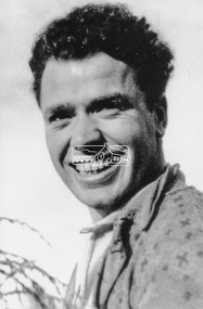
Photograph, Maurie Fabbro at age 20 at Fabbro's farm in Bell Street, Eltham, 1940, 1940
The site of the Fabbro farm (Diamond Creek side land) is now called Barrack Bushlands. It is doubtful that Fabbro's farm holding was ever called Barrak Park, This title is fairly recent after the Shire of Eltham purchased the land, including the last section in 1993/94. About this time the area on the west side of Falkiner Street was purchased by a private developer and developed as housing. The area in Bell Street opposite the Eltham High School was purchased by the State Government is recent years and is called Fabbro Fields. The Fabbro Family operated their farm in Bell Street, Eltham. Maurice Joseph Fabbro (Mario) was born 19 January 1920 and passed away 19 November 20091 black and white photographfabbro's farm, maurice fabbro -
 Eltham District Historical Society Inc
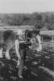
Photograph, Guildo Fabbro, Falkiner Street, Eltham with Clydesdale horse
Guildo Fabbro, Falkiner Street, Eltham with Clydesdale horse with harness in field. The site of the Fabbro farm (Diamond Creek side land) is now called Barrack Bushlands. It is doubtful that Fabbro's farm holding was ever called Barrak Park, This title is fairly recent after the Shire of Eltham purchased the land, including the last section in 1993/94. About this time the area on the west side of Falkiner Street was purchased by a private developer and developed as housing. The area in Bell Street opposite the Eltham High School was purchased by the State Government is recent years and is called Fabbro Fields. The Fabbro Family operated their farm in Bell Street, Eltham. 1 black and white photographfabbro's farm, guido fabbro, bell street, clydesdale horse -
 Eltham District Historical Society Inc
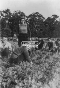
Photograph, At Bell Street; from left: Maurie Fabbro, Myra Skipper, Unknown, Arthur Munday, Ian Robertson. Helen Comprione in front
At Bell Street, Fabbro Farm, Eltham; from left: Maurie Fabbro, Myra Skipper, Unknown, Arthur Munday, Ian Robertson. Helen Comprione in front - probably helping to pick a crop. The site of the Fabbro farm (Diamond Creek side land) is now called Barrack Bushlands. It is doubtful that Fabbro's farm holding was ever called Barrak Park, This title is fairly recent after the Shire of Eltham purchased the land, including the last section in 1993/94. About this time the area on the west side of Falkiner Street was purchased by a private developer and developed as housing. The area in Bell Street opposite the Eltham High School was purchased by the State Government is recent years and is called Fabbro Fields. The Fabbro Family operated their farm in Bell Street, Eltham. 1 black and white photographfabbro's farm, guido fabbro, bell street, arhur munday, eltham, helen comprione, ian robertson, maurice fabbro, myra skipper, picking, farming -
 Eltham District Historical Society Inc
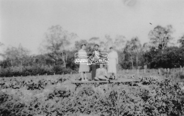
Photograph, From left: Unknown, Mario Fabbro and possibly Helen Skipper, Bell Street, Eltham
At Bell Street, Fabbro Farm, Eltham; From left: Unknown, Mario Fabbro and possibly Helen Skipper, standing in the middle of a vegetable crop. The site of the Fabbro farm (Diamond Creek side land) is now called Barrack Bushlands. It is doubtful that Fabbro's farm holding was ever called Barrak Park, This title is fairly recent after the Shire of Eltham purchased the land, including the last section in 1993/94. About this time the area on the west side of Falkiner Street was purchased by a private developer and developed as housing. The area in Bell Street opposite the Eltham High School was purchased by the State Government is recent years and is called Fabbro Fields. The Fabbro Family operated their farm in Bell Street, Eltham. 1 black and white photographfabbro's farm, bell street, eltham, maurice fabbro, farming, helen skipper, vegetables -
 Eltham District Historical Society Inc
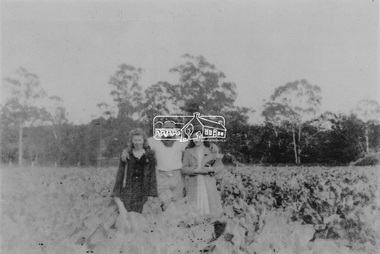
Photograph, At Bell Street, Eltham; from left: Helen Skipper, Matcham Skipper, Sonia Skipper and possibly Myra Skipper
At Bell Street, Fabbro Farm, Eltham; From left: Helen Skipper, Matcham Skipper, Sonia Skipper and possibly Myra Skipper, standing in the middle of a vegetable crop. The site of the Fabbro farm (Diamond Creek side land) is now called Barrack Bushlands. It is doubtful that Fabbro's farm holding was ever called Barrak Park, This title is fairly recent after the Shire of Eltham purchased the land, including the last section in 1993/94. About this time the area on the west side of Falkiner Street was purchased by a private developer and developed as housing. The area in Bell Street opposite the Eltham High School was purchased by the State Government is recent years and is called Fabbro Fields. The Fabbro Family operated their farm in Bell Street, Eltham. 1 black and white photographfabbro's farm, bell street, eltham, farming, helen skipper, vegetables, matchcam skipper, myra skipper, sonia skipper -
 Eltham District Historical Society Inc
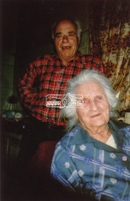
Photograph, Maurice Fabbro and his mother Regina (wife of Guido) taken at home in Falkiner Street, Eltham
Maurice Fabbro and his mother Regina (wife of Guido) taken at home in Falkiner Street, Eltham. Regina passed away 21/03/1986 age 92 and is buried at Eltham Cemetery. (source: http://www.elthamcemetery.com/index.php/deceased-search) The site of the Fabbro farm (Diamond Creek side land) is now called Barrack Bushlands. It is doubtful that Fabbro's farm holding was ever called Barrak Park, This title is fairly recent after the Shire of Eltham purchased the land, including the last section in 1993/94. About this time the area on the west side of Falkiner Street was purchased by a private developer and developed as housing. The area in Bell Street opposite the Eltham High School was purchased by the State Government is recent years and is called Fabbro Fields. The Fabbro Family operated their farm in Bell Street, Eltham. Eltham, Falkiner Street, Maurice Fabbro, Regina Fabbro1 colour photographfabbro's farm, bell street, eltham, maurice fabbro, regina fabbro -
 Eltham District Historical Society Inc
Photograph, Fabbro's farm, Bell Street, Eltham, c.1990s
Fabbro's farm and house, Bell Street, Eltham, c.1990s. A crop of artichokes were planted on the farm at this time. The site of the Fabbro farm (Diamond Creek side land) is now called Barrack Bushlands. It is doubtful that Fabbro's farm holding was ever called Barrak Park, This title is fairly recent after the Shire of Eltham purchased the land, including the last section in 1993/94. About this time the area on the west side of Falkiner Street was purchased by a private developer and developed as housing. The area in Bell Street opposite the Eltham High School was purchased by the State Government is recent years and is called Fabbro Fields. The Fabbro Family operated their farm in Bell Street, Eltham. 1 colour photograph printed with white borderfabbro's farm, bell street, eltham, artichokes, barak farm -
 Eltham District Historical Society Inc
Photograph, Artichokes growing at Bell Street, Eltham, c.1990s
Fabbro's farm and house, Bell Street, Eltham, c.1990s. A crop of artichokes were planted on the farm at this time. The site of the Fabbro farm (Diamond Creek side land) is now called Barrack Bushlands. It is doubtful that Fabbro's farm holding was ever called Barrak Park, This title is fairly recent after the Shire of Eltham purchased the land, including the last section in 1993/94. About this time the area on the west side of Falkiner Street was purchased by a private developer and developed as housing. The area in Bell Street opposite the Eltham High School was purchased by the State Government is recent years and is called Fabbro Fields. The Fabbro Family operated their farm in Bell Street, Eltham. 1 colour photograph printed with white borderfabbro's farm, bell street, eltham, artichokes, barak farm -
 Eltham District Historical Society Inc
Photograph, Maurice Fabbro with artichokes growing at Bell Street, Eltham, c.1990s. Maurie is in his 70s
Fabbro's farm and house, Bell Street, Eltham, c.1990s. A crop of artichokes were planted on the farm at this time. The site of the Fabbro farm (Diamond Creek side land) is now called Barrack Bushlands. It is doubtful that Fabbro's farm holding was ever called Barrak Park, This title is fairly recent after the Shire of Eltham purchased the land, including the last section in 1993/94. About this time the area on the west side of Falkiner Street was purchased by a private developer and developed as housing. The area in Bell Street opposite the Eltham High School was purchased by the State Government is recent years and is called Fabbro Fields. The Fabbro Family operated their farm in Bell Street, Eltham. 1 colour photograph printed with white borderfabbro's farm, bell street, eltham, artichokes, barak farm, maurice fabbro -
 Eltham District Historical Society Inc
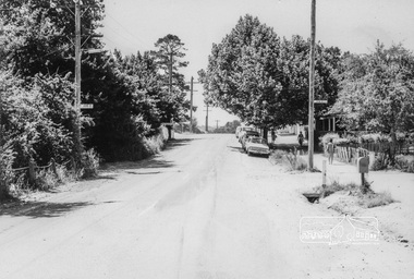
Photograph, Looking North along Main Road near intersection with John Street, Eltham, February 1968, Feb 1968
Shows cars parked outside Burgoyne's store on the east side In February 1968 an unknown person took a series of photos from the Eltham Hotel at Pitt Street heading north along Main Road through the shopping centre to just north of Elsa Court covering the length of the section of Main Road which was duplicated shortly thereafter. Shows the condition and environment of the streesscape of Main Road, Eltham immediately prior to the duplication between Pitt Street and Elsa Court through the shopping centre. Also shows a number of shops and businesses that operated at that time.Black and white photographduplication, eltham, main road, burgoyne's shop, john street -
 Eltham District Historical Society Inc
Photograph, Liz Pidgeon, Heritage Excursion; Eltham Lower Park Walk and Talk, 1 July 2017, 1 July 2017
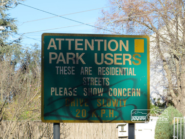
... Street signage: Attention park users these are residential... melbourne Street signage: Attention park users these are residential ...Street signage: Attention park users these are residential streets please show concern drive slowly 20 m.p.h with graffiti Newsletter No., 234, June 2017 Heritage Excursion - Saturday 1st July - Eltham Lower Park - Walk and Talk Eltham Lower Park has played an important part in the history of our area since the early days of European settlement when it was used by local residents as an informal racecourse. Prior to that its location at the junction of the Diamond Creek and the Yarra River made it an important meeting place for the Wurundjeri people. The park combines formal elements and sporting facilities with remnant bushland that is of environmental significance. It is home to sporting and horse riding clubs, popular play spaces and the Diamond Valley Miniature Railway, which attracts large numbers of visitors. The park will be the venue for our July excursion which will comprise a walk of about 3.5 km around the park and adjacent areas. Along the way we will discuss the history and natural history of the area. The path along the creek and the river provides a pleasant and scenic walk. This walk on Saturday 1st July is about 3.5 km in length and will take 2 to 2.5 hours. It will start at 2pm at the Main Road car park at the front of the park. (Melway ref 21 H 10). Born Digitalheritage excursion, activities, eltham district historical society, eltham lower park, sign, grafitti -
 Eltham District Historical Society Inc
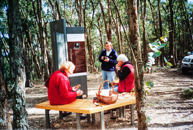
Photograph, Liz Pidgeon, Heritage Excursion; The 1901 Eltham Railway Walk, 3 May 2014, 3 May 2014
Newsletter No. 216, May 2014 May Excursion – The 1901 Eltham Railway Walk The railway from Heidelberg to Eltham was opened in 1902. Over the previous year railway construction cut a curving swathe through Josiah Holloway’s 1851 Little Eltham subdivision. The survey plans for the railway show the owners and occupiers of land within Little Eltham affected by the railway alignment and for some distance each side. The plans show houses and other buildings but development at that time was rather sparse. Copies of these plans from the State Library of Victoria collection have been provided to the Society by Alan Sheehan. For our walk on 3rd May we intend to follow the railway from the Eltham Station to Ryans Road, which was the boundary of the adjoining Montmorency Farm. The return will be by way of nearby streets. Along the way we will discuss the details shown on the railway plans as well as more recent railway documents and photographs. At the conclusion and if time permits we can inspect the historical display at the Eltham Station. The walk is about 3 km in length and will take about 2.5 hours. It will start at 2 pm at the Eltham Railway Station car park (east/Main Road side) (Melway Ref. 21 J5).Born Digitalheritage excursion, activities, eltham district historical society, eltham railway station, eltham library, trestle bridge -
 Eltham District Historical Society Inc
Photograph, Liz Pidgeon, Heritage Excursion; The 1901 Eltham Railway Walk, 3 May 2014, 3 May 2014
Newsletter No. 216, May 2014 May Excursion – The 1901 Eltham Railway Walk The railway from Heidelberg to Eltham was opened in 1902. Over the previous year railway construction cut a curving swathe through Josiah Holloway’s 1851 Little Eltham subdivision. The survey plans for the railway show the owners and occupiers of land within Little Eltham affected by the railway alignment and for some distance each side. The plans show houses and other buildings but development at that time was rather sparse. Copies of these plans from the State Library of Victoria collection have been provided to the Society by Alan Sheehan. For our walk on 3rd May we intend to follow the railway from the Eltham Station to Ryans Road, which was the boundary of the adjoining Montmorency Farm. The return will be by way of nearby streets. Along the way we will discuss the details shown on the railway plans as well as more recent railway documents and photographs. At the conclusion and if time permits we can inspect the historical display at the Eltham Station. The walk is about 3 km in length and will take about 2.5 hours. It will start at 2 pm at the Eltham Railway Station car park (east/Main Road side) (Melway Ref. 21 J5).Born Digitalheritage excursion, activities, eltham district historical society, eltham railway station, eltham library, trestle bridge