Showing 16996 items
matching plenty-river
-
 Stawell Historical Society Inc
Photograph, Major Mitchell Trail Plaque near the Richardson River
Major Mitchell Trail Plaque Near Richardson Riverstawell -
 Stawell Historical Society Inc
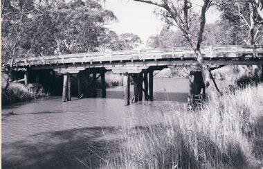
Photograph, Wooden Wimmera River Bridge at Glenorchy -- 2 Photos
Two photographs of Wooden Wimmera River Bridge at Glenorchystawell -
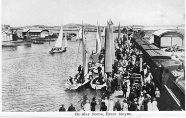 Port Fairy Historical Society Museum and Archives
Photograph, River Moyne
Port Fairy Souvenir Folder including river MoyneBlack and white photograph from souvenir foldersouvenir folder, moyne river, couta boat, wharf -
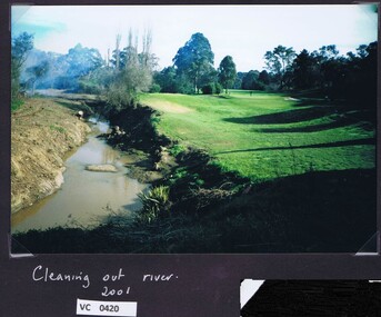 Heidelberg Golf Club
Photograph, Cleaning out the river 2000: Heidelberg Golf Club, 2000
Cleaning out the river 2000 at Heidelberg Golf Club.Colour photograph and caption.hgc course, plenty river -
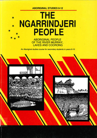 Victorian Aboriginal Corporation for Languages
Book, Education Department of South Australia, The Ngarrindjeri people : Aboriginal people of the River Murray, Lakes and Coorong : an Aboriginal studies course for secondary students in Years 8-10, 1990
An Aboriginal studies course detailing the history, culture and life experiences of the original peoples of the areas along the River Murray, Lakes and Coorong. It is part of the 8-12 Aboriginal studies program developed to meet the needs of students, teachers and Aboriginal people.maps, b&w illustrations, b&w photographs, oral histories, suggested class activitiesngarrindjeri, river murray, coorong, aboriginal studies, secondary school education, oral history, curriculum development -
 Tarnagulla History Archive
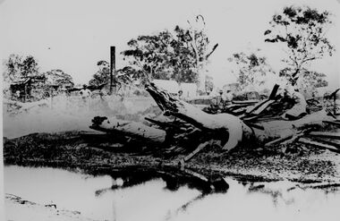
Photographs: Loddon River, Newbridge after flood, Loddon River, Newbridge after flood, 1909 (original image)
On 20th August,1909 the Laanecoorie Weir broke away and released 18.3 million cubic metres of water through the opening and causing severe damage to all towns downstream. At Newbridge, Petersen's bakery collapsed and Simpson's Store and Hotel flooded to the roof. The billiard table was later found in a tree five miles down the Loddon near Learmonth. Murray Comrie Collection. Two copies of a monochrome photograph, image part of damaged bridge in the area near Loddon River at Newbridge after major flood in 1909. This is a very grainy and dark copy of an older original. Copy probably made by Murray Comrie in the 1960s.newbridge, loddon river, flood, bridge -
 Greensborough Historical Society
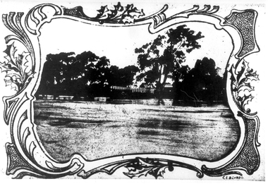
Map, Melbourne and Metropolitan Board of Works. Survey Division, MMBW, Yarra 2500 / 13.23. Plenty, Happy Hollow, 1979_03
Melbourne and Metropolitan Board of Works. Yarra 2500 [base map] 13-23. Plenty / Happy Hollow. Parishes of Morang 3183, Nillumbik 3310 and Keelbundora 2856. Municipalities of Diamond Valley 257 and Whittlesea 239. Prominent streets include: McLaughlans Lane and Happy Hollow Drive. Includes Janefield Colony Reserve.MMBW Map in 1:2500 [scale] series. Cream parchment with green tape reinforcing on edges and punched holes on left edge.mmbw, melbourne and metropolitan board of works, shire of diamond valley, plenty - maps, happy hollow -
 Greensborough Historical Society
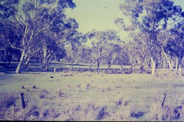
Slide - Photograph, John Ramsdale, River red gums around Yan Yean: Slide 73, 1990s
Photograph shows river red gums around Yan YeanPart of the John Ramsdale collection of slides and audio visual material.Colour photograph scanned from slide.No maker's marks. No caption on slide.yan yean, red gums -
 Greensborough Historical Society
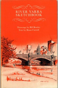
Book, River Yarra sketchbook, 1973_
Illustrated articles about the Yarra River and the features to be seen along it.63 p., black and white illus.yarra river -
 Federation University Historical Collection
Photograph - Colour, Chatham-Holmes Collection: Fishing on the Murray River, 1980s, 1980s
Philip and Elizabeth Chatham with family'friends fishing on the banks of the Murray River.Coloured photographs with negatives includedchatham-holmes collection, philip chatham, elizabeth chatham, murray river, fishing -
 Stawell Historical Society Inc
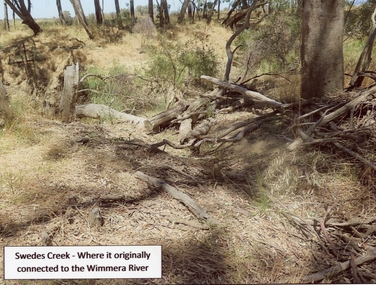
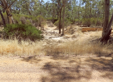
Photograph, Swedes Creek where it originally connected to the Wimmera River 2017
Swedes Creek where it originally connected to the Wimmera River. 2017water -
 Lakes Entrance Regional Historical Society (operating as Lakes Entrance History Centre & Museum)
Photograph, 1997
County Antrim was wrecked off coast opposite Metung Victoria January 1897Small format colour photograph of a painting of the SS Riverina which was wrecked off the coast, and the painting is at the Hotel in Cann River, Victoriabuildings, fences, waterways, ships and shipping -
 Whittlesea Historical Society Inc.
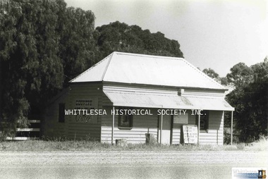
Photograph, Miss Janet Gordon's Cottage, Plenty Road, South Morang, 1985
Miss Janet Gordon's cottage on the corner of Plenty Road at South Morang. In the 1980s, Mrs. L. Dynon leased the house and opened her shop "Charlotte's Web" there. She would advertise and hold spinning demonstrations, have art and craft work on display and for sale, as well as fleece. The building was destroyed by fire in the 1990's.Photograph print, also digital image on HD.south morang, janet gordon, gordon family, charlotte's web south morang, plenty road south morang, art craft shop, plenty road shop -
Greensborough Historical Society
Article, Ian Lamont, An early history of Plenty Valley FM Radio 1987-1998, 1987o
Plenty Valley FM made its first test broadcast in July 1988, then known as Outer North Eastern Community Radio. After obtaining its broadcasting licence, regular broadcasts commenced in December 1990. The author of this article, Ian Lamont, was first Station President (1987-91) and first Station Manager (1993-98).3 pages text and one photo.plenty valley community radio, plenty valley fm, ian lamont -
 Kew Historical Society Inc
Photograph - Yarra River in flood at the Willsmere Park, 1993
Willsmere Park is bounded by the the Yarra River, Green Acres Golf Club, Willow Grove and the Eastern Freeway. The land on which the park is now situated was bought by Thomas Wills at the Crown Land Sales of 1846 (Section 56). From the 1840s to the 1940s it was intensively farmed. The park is dominated by very large playing fields, while planting to the southern boundary was undertaken when the Eastern Freeway was built. It is only along the banks of the Yarra that there is any remnant native vegetation. Willsmere Park is of significance as an area of open land that remains from the flood plain that once dominated northern Kew. (Source: Kew Conservation Study, 1988)Original colour small format polaroid photograph of the Yarra River in flood at the Willsmere Park, taken on 16 September 1993."Yarra River at Willsmere Park Flooding 16.9.93"willsmere park, yarra river -- floods -- kew (vic.) -
 Marysville & District Historical Society
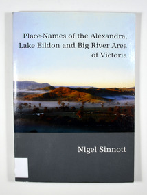
Book, Place-Names of the Alexandra, Lake Eildon and Big River Area of Victoria, 2003
Place names of the Alexandra, Lake Eildon and Big River areas in VictoriaPaperback. Front cover has a colour photograph named: 'Sunrise, Brooks Cutting near Alexandra', by Robert Douglas (2002). Back cover has a colour photograph of the author, Nigel Sinnott at McKenzie's Pinch, Alexandra (Mount Torbreck in background) by Robert Douglas (2002).To George Edwards / with best wishes, / Nigel Sinnott / 15 March 2003 To the memory of / Gordon BEATON (1911-88) / of Eildon / mycologist and engineer Stamp of Marysville & District / Historical Society Inc / P.O. Box 22 / Marysville 3779 geographical, victoria, big river region, eildon region, alexandra region, alexandra library, friends -
 Greensborough Historical Society
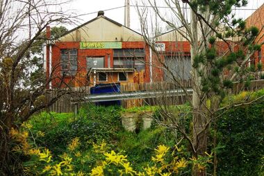
Photograph - Digital image, Marilyn Smith, Main Street mower shop from the river, 16/08/2015
The back of the mover shop on 125 Main Street, taken from the river.Digital copy of colour photographmain street greensborough -
 Stawell Historical Society Inc
Photograph, Bush Saw Mill on the Wimmera river 1887
Bush Saw Mill by Charles Nettleton. Wimmera River of Victorian 1887stawell manufacture -
 Stawell Historical Society Inc
Photograph, Greens Creek Bridge on the Wimmera River 1929
Greens Creek Bridge on the Wimmera River built in 1929 now demolished.stawell -
 Stawell Historical Society Inc
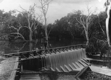
Postcard, Faux Weir on the Wimmera River near Lubeck 1909 -- Postcard
Faux Weir built across Wimmera River near Lubeck 1909water -
 Stawell Historical Society Inc
Photograph, Dunmunkle Creek looking towards Wimmera River 2017 -- Coloured
Colour Photo of Dunmunkle Creek looking towards Wimmera River 2017water -
 Stawell Historical Society Inc
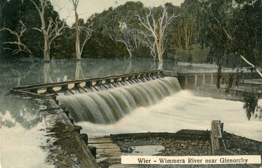
Postcard, Wimmera River Weir at Glenorchy -- Postcard
Wimmera River Weir Glenorchy with letter written on card and 1d stampwater -
 Kew Historical Society Inc
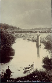
Postcard, River Yarra near Macauleys' Boathouse Kew, c.1910
The Pipe Bridge was constructed to bring fresh water from Fairfield to Kew. This bridge was destroyed in the 1934 Flood and later reconstructed.Early sepia real photo postcard of the first Pipe Bridge bringing water from the Yan Yean Reservoir to Kew. The site is upriver of the original Macauley's boathouse. Obverse: "River Yarra near Macauleys' Boat House Kew". Reverse: "(Pipe Water Line) / Kew to Fairfield above boat house / Pipe Bridge / Received from L. Bennett 1980".bridges - kew (vic.), bridges - yarra river -- kew (vic.), pipe bridge -
 Greensborough Historical Society
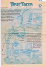
Newspaper - Newspaper Clipping, The Age, Your Yarra, The river and the city it created, 23/09/1980
Newspaper liftout about the Yarra River, early Melbourne and Port Phillip Bay.Newspaper article from The Age Newspaper, 2 sided printed in blue and black with photosyarra river, port phillip bay, melbourne -
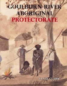 Ballarat Heritage Services
Book, Ian Clark, 'Goulburn River Aboriginal Protectorate' By Ian Clark
Gouburn River Aboriginal Protectorate was published by BHS Publishing and written by Ian Clark. gouldburn river, aboriginal protectorate, aborigines, le souef, ian clark -
 Wonga Park Community Cottage History Group
Photograph (Item) - Black and White, Wonga Park: Yarra River with Crooning Waters house and Mt Lofty
Wonga Park: A view of the Yarra River with Crooning Waters house and Mt LoftyPhoto is named 14880031.jpg on CD -
 Stawell Historical Society Inc
Photograph, "Woodlands" Homestead on Wimmera River near Crowlands -- Shearing Shed -- Coloured
Coloured Photo of Shearing Shed at Woodlands Homestead on Wimmera River near Crowlandsstawell -
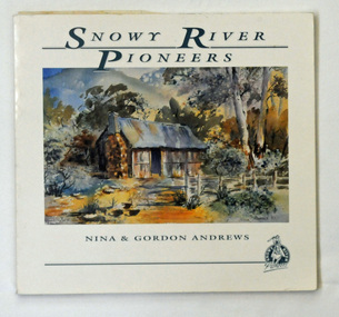 Orbost & District Historical Society
book, Andrews, Gordon, Snowy River Pioneers, 1990
This book was produced by Gordon and Nina Andrews of Netherbyre in Orbost.This is a locally created book. It helps to tell the story of who the Snowy River pioneers and therefore how we came to settle here. It is a useful research tool and is significant to the history of the Orbost area.A 47pp soft covered book titled, Snowy River Pioneers, by Gordon and Nina Andrews, On the front cover is a coloured painting of a hut in bushland. It contains Charles West and other selected stories. The text is by Gordon Andrews. The artwork is by Nina Andrews and Vere Moon.Copyright 1990 Gordon & Nina Andrews Netherbyre, Orbost 3888snowy-river-pioneer stockmen -
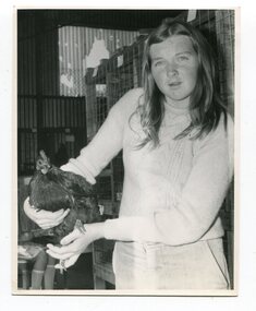 Orbost & District Historical Society
photographs, Snowy River Mail, C1968
These photographs were probably published in the Snowy River Mail. Some of the Orbost identities in the photographs are: Jim Holden; Brian Morgan; Clarrie Ingram; Jeffrey Fecondo; David Holden; Brian Holden; Richard Morgan; Sue Joiner and Charlie Owen. They were taken in the Poultry Shed at the Orbost Show at the Newmerella Showground. The first meeting to form an Agricultural society in Orbost was convened by the then Orbost Progress Association and held in the Mechanics Hall on Saturday, 10th October 1891. Its first show was held on 3rd March 1904...on a site alongside the Bonang Road where the present Golf Club stands. It is currently held at the Recreation Reserve at Newmerella. (Ref: In Times Gone By-Deborah Hall)These photographs are associated with the Orbost Agricultural Society 's Annual Show which has been a major event in Orbost for over a century. Agricultural shows are an important part of cultural life in small country towns and the Orbost Show is an integral part of Orbost 's agricultural history.Twenty-two black / white photographs and four coloured photographs. all are related to the Orbost Agricultural Show.poultry agriculture-show-orbost -
 Stawell Historical Society Inc
Drawing, "Woodlands" Homestead on Wimmera River near Crowlands -- Drawing
Drawing of Woodlands Homestead on Wimmera River near Crowlands the seat of John Wilson Esqstawell