Showing 4013 items
matching surveying
-
 Bendigo Historical Society Inc.
Document - MINING REPORTS - DEFIANCE MINE, SEBASTAPOL
Carbon copy of handwritten quote from Dept. of Mines, Memoirs of Geological Survey of Victoria by W. Baragwanath. Notes include theworkings of the Company, gold yield, dividends and re-organization of the Company.document, gold, mining reports, mining reports, defiance mine sebastapol, dept mines, memoirs of geological survey of victoria, w baragwanath, the ballarat goldfield, the cumberland durham and cornish company, sebastapol company, nelson and wellington company, defiance company, a richardson -
 Bendigo Historical Society Inc.
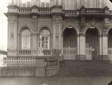
Photograph - BENDIGO HISTORICAL POST OFFICE
Thirteen large format black & white photographs of Bendigo Historical Post Office with Australian Survey Office, Oct 1981printed in oval stamp on reverse. Also included is a number S.F. 132bendigo, institutions, bendigo post office -
Port Melbourne Historical & Preservation Society
Plan, Department of Lands and Survey, The Township of Sandridge, 25 Nov 1860
Plan of the township of Sandridge lithographed at the department of Lands and Survey, Melbourne 5th November, 1860. Identical to 1859 version except for added rail line through Sandridge and onto Town Pierengineering - roads streets lanes and footpaths, municipal district of sandridge -
Port Melbourne Historical & Preservation Society
Map - Chart, Port Phillip, 1930
Photocopy in two large sections, of soundings chart for Port Phillip Bay, surveyed by Commander Henry L Cox RN, 1864, with corrections and additions to 1921. Top section (two copies)(Original had stamp of John Donne & Son Stationers)transport - shipping, hobson's bay, port phillip bay -
Bendigo Historical Society Inc.
Map - VICTORIA, Circa 1926
Map: Map showing Counties, including Railway lines and Geographic features. Compiled and engraved at the Department of Lands and Survey Melbourne, Revised October 1926 ( number 184 in Map Cupboard 1)map, victoria, counties, counties of victoria, geographic features -
 Whitehorse Historical Society Inc.
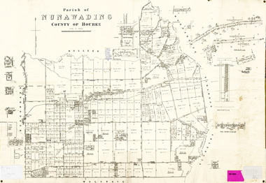
Legal record - Map, Parish of Nunawading, c1930
Office of Lands and survey map, 1864 with many further subdivisions of 1870 onwards added.Office of Lands and survey map, 1864 with many further subdivisions of 1870 onwards added. Boundaries of City of Box Hill included. Note added re Slater's land in Blackburn North. Office of Lands and survey map, 1864 with many further subdivisions of 1870 onwards added. maps, shire of blackburn and mitcham, city of box hill, slater family -
Whitehorse Historical Society Inc.
Article, Support for mergers, 1994
Nunawading Council resident survey revealed 25% favoured a Nunawading / Box Hill merger, which is the Nunawading Council's preferred optionNunawading Council resident survey revealed 25% favoured a Nunawading / Box Hill merger, which is the Nunawading Council's preferred option. Other favoured options ranged from 10% to 19%.Nunawading Council resident survey revealed 25% favoured a Nunawading / Box Hill merger, which is the Nunawading Council's preferred optionlocal government, amalgamations, city of nunawading, city of box hill, city of whitehorse, city of ringwood, city of doncaster and templestowe, city of waverley -
 Whitehorse Historical Society Inc.
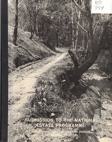
Document, Submission to the National Estate Programme, ca 1974
Submission to the National Estate Programme: Schwerkolt Cottage, Yarran Dheran and associated areas, City of Nunawading, 1974?.Submission to the National Estate Programme: Schwerkolt Cottage, Yarran Dheran and associated areas, City of Nunawading, 1974?. Includes 'Report on the survey of the vascular flora of the Yarran Dheran Reserve, by A.B. Court.Submission to the National Estate Programme: Schwerkolt Cottage, Yarran Dheran and associated areas, City of Nunawading, 1974?.city of nunawading, parks and reserves, schwerkolt cottage, yarran dheran, webster, noel, court, a.b., native plants -
Bendigo Historical Society Inc.
Map - PANNOOMILLOO : COUNTY OF BENDIGO, 1957
Map. Pannoomilloo, County of Bendigo, Pannoobamawm, Milloo, Warragamba, Diggorra, Property Allotments. Drawn and Reproduced at the Department of Lands and Survey,1957. Price 2/-. (number 412 in Map Cupboard 1 ).W.M. Houston, Government Printer, Melbourne.bendigo, hospital -
Port Melbourne Historical & Preservation Society
Poster - Map showing ancesttral family estates of Melbourne's first people pre European Settlement, Marcus Lee Design, This once as it was - the ancestral family estates of Melbourne's first people, 2016
This once as it was - the ancestral family estates of Melbourne's first people. Colour map with text. Pre European settlement. Based on Colonial survey maps of Port Phillip Bay region. 1837 and 1864indigenous australians, natural environment, arweet derrmut, point ormond, st kilda, yuro yuroke, bunjil, burrarung river, queensbridge falls -
 Bendigo Historical Society Inc.
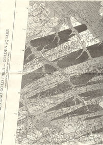
Map - LONG GULLY HISTORY GROUP COLLECTION: BENDIGO GOLD FIELD - GOLDEN SQUARE GEOLOGICAL SURVEY OF VICTORIA
BHS CollectionPart of a map of the Bendigo Gold Field - Golden Square. Geological Survey of Victoria. Shown are reefs, faults and anticlines. Many of the mines are shown on the map. Gullies, hills and streets are also shown.bendigo, history, long gully history group, the long gully history group - bendigo gold field - golden square geological survey of victoria, north bendigo state school reserve, hospital reserve, benevolent asylum reserve, empire hill, richmond hill, raes hill, south end hill, victoria hill, new chum hill, iron bark hill, redan hill, view hill, hustlers hill, camp hill -
 Melbourne Tram Museum
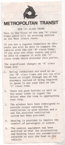
Pamphlet, "New 'A' class trams, June 1984
The A class tram was launched on the Mont Albert route 12 June 1984 - from Don Storey's timeline history notes.Yields inforamation about the new A class trams at the time of their launch.Part of a pamphlet given to passengers at the time of the launch of the new A class trams on the Mont Albert line - has a perforated edge on the left hand side, indicating it was part of a survey or response form.tramways, tramcars, new trams, surveys, a class, mont albert -
Surrey Hills Historical Society Collection
Work on paper - Vertical file, Cragg, Thomas
A vertical file containing the following information: 1. Extract from research of Alan Holt re Elgar Survey (Holt file 28): Memorandum of agreement 14.3.1882 and plan (3 pages). -
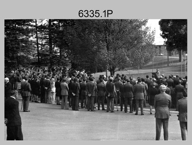
 Bendigo Military Museum
Photograph - RSM-Army Visit – Technical Tour, Army Survey Regiment Fortuna, Bendigo, 1989
This is a set of 16 photographs of a visit to the Army Survey Regiment, by the Regimental Sergeant-Major of the Australian Army (RSM-A) WO1 Kevin (Lofty) Wendt OAM, BEM on the 10th of August 1989. He was taken on a tour through the production areas and messes. RSM-A WO1 Kevin (Lofty) Wendt OAM, BEM was the 2nd RSM to be appointed to the position of RSM-A, the most senior Warrant Officer position in the Australian Army. His appointment was from 1987 to 1990. On this occasion he was escorted by WO1 Neville Stone, who was the RSM of the Army Survey Regiment from 1988 to 1990. Refer to item 6438.15P for photos of the SGT’s Mess function.This is a set of 16 photographs of a visit to the Army Survey Regiment, Fortuna, Bendigo by the Regimental Sergeant-Major of the Australian Army (RSM-A) WO1 Kevin (Lofty) Wendt OAM, BEM on the 10th of August 1989. The photographs are on 35mm negative film and were scanned at 96 dpi. They are part of the Army Survey Regiment’s Collection. .1) to .2) - Photo, black & white, 1989. Wild B8 plotting on the AUTOMAP 2 system, L to R: WO1 Russell ‘Rusty’ Williams, RSM-A WO1 Kevin (Lofty) Wendt OAM, BEM, SPR Stuart Bowd. .3) to .5) - Photo, black & white, 1989. RAAF Charting, L to R: SSGT Dennis Learmonth, RSM-A WO1 Kevin (Lofty) Wendt OAM, BEM. .6) - Photo, black & white, 1989. RAAF Charting, L to R: SSGT Dennis Learmonth, RSM-A WO1 Kevin (Lofty) Wendt OAM, BEM, unidentified visiting RSM, WO1 Stevo Hinic. .7) to .8) - Photo, black & white, 1989. Map data editing on AUTOMAP 2 system, L to R: SPR Charmian McKean, RSM-A WO1 Kevin (Lofty) Wendt OAM, BEM, WO1 Stevo Hinic. .9) - Photo, black & white, 1989. Map data editing on AUTOMAP 2 system, L to R: SGT Paul ‘Hutch’ Hunter, RSM-A WO1 Kevin (Lofty) Wendt OAM, BEM. .10) - Photo, black & white, 1989. Photo Troop L to R: RSM-A WO1 Kevin (Lofty) Wendt OAM, BEM, WO2 Rob Bogumil. .11) - Photo, black & white, 1989. Print Troop L to R: CPL Peter Swandale, RSM-A WO1 Kevin (Lofty) Wendt OAM, BEM. .12) - Photo, black & white, 1989. Print Troop L to R: RSM-A WO1 Kevin (Lofty) Wendt OAM, BEM, unidentified visiting RSM, CPL Peter Swandale. .13) - Photo, black & white, 1989. OR’s Mess Committee, Tavern L to R: RSM-A WO1 Kevin (Lofty) Wendt OAM, BEM, PMC CPL Brendon McKinless. .14) - Photo, black & white, 1989. OR’s Mess Committee, Tavern L to R: CPL Noel Brinsmead, CPL John Gilbert. .15) - Photo, black & white, 1989. OR’s Mess Committee, Tavern L to R: PMC CPL Brendon McKinless, RSM-A WO1 Kevin (Lofty) Wendt OAM, BEM, CPL Noel Brinsmead, CPL John Gilbert, CPL AM Verley. .16) - Photo, black & white, 1989. OR’s Mess Committee, Tavern L to R: RSM WO1 Neville Stone, PMC CPL Brendon McKinless, RSM-A WO1 Kevin (Lofty) Wendt OAM, BEM, CPL Noel Brinsmead, CPL John Gilbert, CPL AM Verley, CPL Dave Cook..1P to .16P – no annotationsroyal australian survey corps, rasvy, army survey regiment, army svy regt, fortuna, asr -
 Bendigo Military Museum
Administrative record - Royal Australian Survey Corps 80th Birthday Parade 1 July 1995, Army Survey Regiment, Bendigo, June 1995
This is a booklet describing the Australian Survey Corps 80th Birthday Parade held at the Army Survey Regiment Parade ground at Fortuna on 1 July 1995. 1 July 1915 was the date of the formation of the Australian Survey Corps. The booklet lists the Reviewing Officer Major General GD Carter AM, Deputy Chief of the General Staff, Host officer, Official Guest, Senior Regimental appointments, the Order of Ceremony and a complete list of Army Survey Regiment members on parade.Small A5 sized booklet, soft cardboard covered with paper pages with two staples. Each page of the booklet has been scanned and combined into a video in .mp4 format. The video is 50Kb in size and runs for 50 seconds.royal australian survey corps, rasvy, fortuna, army survey regiment, army svy regt, asr -
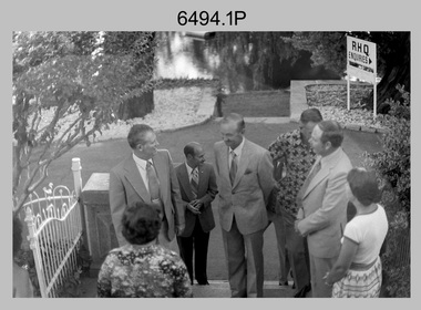
 Bendigo Military Museum
Photograph - Minister for Defence’s Visit to the Army Survey Regiment, Fortuna, Bendigo, c1978
This collection of 16 photos was most likely taken in 1978. Mr Denis James “Jim” Killen was the Minister for Defence in the Fraser Government from 1975 to 1982. It’s evident in these photos he was taken on a tour through the production areas in Air Survey, Cartographic and Lithographic Squadrons. Jim Killen served in the RAAF in WW2 and later had an illustrious career in politics. After receiving his knighthood and an AC for service to Australia, he was known as Sir Denis James "Jim" Killen, AC, KCMG. Key Army Survey Regiment personnel identified include the CO LTCOL Bob Skitch, who led the unit from 1976 to 1980 and WO1 Aub Harvey, who was RSM from 1976 to 1982.This is a set of photographs of a visit to the Army Survey Regiment, Bendigo c1978, by Mr D.J Killen who was the Minister for Defence. The photographs were printed on photographic paper and are part of the Army Survey Regiment’s Collection. The photographs were scanned at 300 dpi. .1) - Photo, black and white, c1978. L to R: Unidentified, Mr D.J. Killen and CO LTCOL Bob Skitch. .2) - Photo, black and white, c1978. L to R: CO LTCOL Bob Skitch and Mr D.J. Killen. .3) - Photo, black and white, c1978. L to R: Unidentified, SPR Mark Lander. .4) - Photo, black and white, c1978. L to R: MAJ Peter Eddy, Mr D.J. Killen. .5) - Photo, black and white, c1978. L to R: CPL Alan Staley, Mr D.J. Killen, MAJ Peter Eddy. .6) - Photo, black and white, c1978. L to R: CPL Robert Cocksedge, Mr D.J. Killen, MAJ Peter Eddy, unidentified. .7) - Photo, black and white, c1978. L to R: CPL Mick Davey, Mr D.J. Killen, MAJ Peter Eddy. .8) - Photo, black and white, c1978. L to R: CPL Mick Davey, MAJ Peter Eddy, Mr D.J. Killen, CO LTCOL Bob Skitch. .9) - Photo, black and white, c1978. L to R: Unidentified, Mr D.J. Killen. .10) - Photo, black and white, c1978. L to R: Unidentified, Mr D.J. Killen. SGT Bob Scaddan. .11) - Photo, black and white, c1978. L to R: Unidentified, Mr D.J. Killen, LCPL Laurel (Ryant) Staley. .12) - Photo, black and white, c1978. L to R: CAPT Gary Kenney, Mr D.J. Killen. .13) - Photo, black and white, c1978. L to R: CAPT Gary Kenney, Mr D.J. Killen, RSM Aub Harvey. .14) - Photo, black and white, c1978. L to R: Unidentified, unidentified, Mr D.J. Killen, CAPT Gary Kenney, .15) - Photo, black and white, c1978. L to R: CO LTCOL Bob Skitch, Mr D.J. Killen, CAPT Gary Kenney. .16) - Photo, black and white, c1978. L to R: Mr D.J. Killen, unidentified, CAPT Gary Kenney.royal australian survey corps, rasvy, army survey regiment, army svy regt, fortuna, asr -
University of Melbourne, Burnley Campus Archives
Plan, [Historical Maps of Richmond Park], 1862-2000
(1) Proposed reserve for Horticultural & Experimental Garden in the Survey paddock Richmond. R.19A (1865). Shows Swan Street Extension. Gazettals 1877, 1887. (2) As (1). Half of map only Annotation by A. Purchas, 9 October, 1862. (3) Plan of Richmond park. A.L. Martin Authorised Surveyor, 31st August, 1872. [Dept. of lands & Survey Melbourne, J. Noone, 6th September 1872.] Map in 4 sheets. (4) Richmond Park. Surveyed by Geo. Black, Authorised Surveyor 13.8.91 (2 copies). (5) [Richmond Park] Shows road alignments gazetted 1871 & 1881 (part copy only - Neg. 18375). (6) City of Richmond Parish of Jika Jika County of Bourke. Department of lands & Survey, 1919 (annotations i.e. Melb. City Link, Amrad, etc. to 1994.) (7) Burnley gardens, 2000. Produced by P. Tulk, Institute of Land & Food Resources, Burnley College, 2000 (re area proposed for heritage listing.)richmond park, survey paddock -
 Bendigo Military Museum
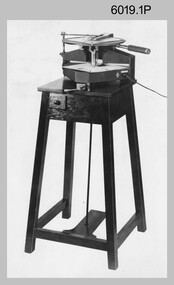
photograph - Royal Australian Survey Corps Aero-triangulation Equipment, 1936 to 1952
Although it’s unknown when these two photos were taken, the South African Pattern Mk IV Slotted Template Machine was in service from 1936 to 1952. The machine was used to cut slots and holes in an acetate film medium. This template was then used to fit several runs of aerial photography to ground control points at a desired scale with a substitution of the templates in the assembly. Radial slots on the templates from central holes representing the photograph’s principal point (centre) were placed over hollow metal studs mounted over control points on the scaled base sheet. The studs represented the intersection of radial lines through common points of detail of overlapping photos. A pricker was used to transfer from the photo-points to the templates. The slotted template methodology was later used as an essential aero-triangulation exercise in advance courses conducted at the School of Military Survey.These three photographs are of a slotted template machine used in aero-triangulation. The first two photographs were printed on photographic paper and are part of the Army Survey Regiment’s Collection. The photographs were scanned at 300 dpi. The third photograph was captured from a collection using a smart phone. .1) and .2) - Photo, black & white, 1936-1952. South African Pattern Mk IV Slotted Template Machine. .3) - Photo, black & white, 1936-1952. WO2 Bob Pratt operating the Slotted Template Machine. .1 and .2 –annotated on back “Slotted Template” .3P - annotated on front “COMPILATION SECTION SLOTTED TEMPLATE MACHINE WO2 BOB PRATT”royal australian survey corps, rasvy, army survey regiment, army svy regt, fortuna, asr, air survey, aerotrig -
 Bendigo Military Museum
Photograph - Military Funeral for SSGT Peter Dew, Army Survey Regiment, Fortuna, Bendigo, 1977
This is a set of five black & white photographs of troops from the Army Headquarters Survey Regiment undertaking ceremonial drill at the military funeral for SSGT Peter Dew in 1977. The location of the funeral service was at Fortuna, Bendigo. He was buried at Bendigo Cemetery in Quarry Hill. Peter Dew died in a tragic accident at home. He was fondly remembered as one of Lithographic Squadron’s colourful personalities. See item 6243.7P for photos of Peter Dew at work in Lithographic Squadron. The "Super Animal of the Year" Peter Dew Memorial Award was an award presented to a member of the squadron for a crude act. To view a photo of this award, refer to item 6230 of the Victorian Collections. This is a set of five black & white photographs of troops from the Army Headquarters Survey Regiment undertaking ceremonial drill at the military funeral for SSGT Peter Dew in 1977. The photographs were printed on photographic paper and are part of the Army Survey Regiment’s Collection. The photographs were scanned at 300 dpi. .1) - Photo, black & white, 1977. Unidentified soldiers and civilians. .2) - Photo, black & white, 1977. In front of the tennis court gates: John McCulloch. Remainder unidentified. .3) - Photo, black & white, 1977. Rifle party rear rank right marker: Russ Mollenhauer. Front rank rifle party commander next to right marker: Greg Kidman. Pall bearers in front of vehicle L to R: Dave Miles, Dick Barwald. Remainder unidentified. .4) - Photo, black & white, 1977. Rifle party commander: Greg Kidman. Right file front to back: Russ Mollenhauer, Peter Breukel, Bill Jones, John Anderson. Remainder unidentified. Left file front to back: unidentified (x2), Rhys De Laine, Frank Lenane, Josh Degroot, Gary Drummond. .5) - Photo, black & white, 1977. Left of minister: Alan Toogood. On right of tree L to R: Max Neil, Bob Hayden, Dave Malligan, Le-Anne (Smallshaw) Shirley, Stan Vote. Remainder unidentified.No personnel are identified.royal australian survey corps, rasvy, army survey regiment, army svy regt, fortuna, asr -
Stawell Historical Society Inc
Map, R.O. Robson - Authorised Surveyor, Road from Glenorchy to near Geary's Selection Callawaddy 1880, 29.04.1880
Survey for Road CreationCloth Backed Map. Plan of Road.Parishes of Richella & Callawadda. County of Borong. Plan of Road. R.O. Robson Authorised Surveyor Stawell 29.04.80 -
 Bendigo Military Museum
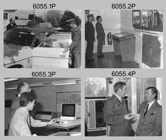
Photograph - MAJGEN Nicholson - Director DMA to the Army Survey Regiment, Bendigo, 1980
This set of nine black and white photographs were taken during the visit to the Army Survey Regiment, Bendigo by the Director of the USA’s Defense Mapping Agency –MAJGEN William L. Nicholson III, on the 7th of February 1980. He was accompanied by US Army COL W.P. ‘Pinky' Holmes and an unidentified Major from the USAF. It is not known if their wives or partners were in attendance.This set of nine black and white photographs were taken during the visit to the Army Survey Regiment, Bendigo by the Director of the USA’s Defense Mapping Agency –MAJGEN William L. Nicholson III, on the 7th of February 1980. The photographs are on 35mm negative film and scanned at 96 dpi. They are part of the Army Survey Regiment’s Collection. .1) - Photo, black & white, 1980. L to R: unidentified civilian (facing away), MAJGEN William L. Nicholson III, MAJ Sam Schwartz US Exchange, CO LTCOL Bob Skitch, D-SVY COL NRJ Hillier, MAJ Don Swiney MBE, Mrs Glen Swiney. .2) - Photo, black & white, 1980. L to R: unidentified civilian & Mrs Glen Swiney, (facing away), MAJGEN William L. Nicholson III, CO LTCOL Bob Skitch, unidentified civilian (facing away). .3) - Photo, black & white, 1980. L to R: unidentified visiting USA officer, MAJ Sam Schwartz US Exchange. .4) - Photo, black & white, 1980. L to R: CAPT Peter Ralston, CAPT Dennis Puniard, CAPT Bob Roche, MAJGEN William L. Nicholson III, CO LTCOL Bob Skitch. .5) - Photo, black & white, 1980. L to R: unidentified (x4), MAJ Sam Schwartz US Exchange, unidentified, CAPT Bob Roche, unidentified (x3), MAJ Paddy Strunks, unidentified, Mrs Glen Swiney, unidentified civilian (facing away)., CAPT Don Maskew, unidentified civilian. .6) - Photo, black & white, 1980. L to R: MAJ Peter Eddy, D-SVY COL NRJ Hillier, CO LTCOL Bob Skitch, MAJGEN William L. Nicholson III, remainder unidentified. .7) - Photo, black & white, 1980. L to R: MAJGEN William L. Nicholson III, CO LTCOL Bob Skitch. .8) - Photo, black & white, 1980. L to R: ADJT CAPT John Harrison, unidentified civilian. .9) - Photo, black & white, 1980. L to R: Mrs Glen Swiney, unidentified civilians (x2).No personnel or civilians are identifiedroyal australian survey corps, rasvy, army survey regiment, army svy regt, fortuna, asr -
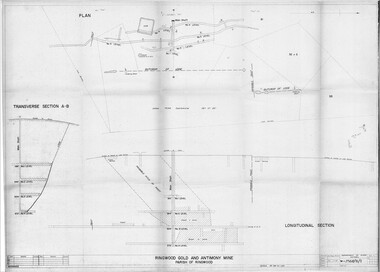 Ringwood and District Historical Society
Plan - Department of Mines, Victoria, Ringwood Gold and Antimony Mine - 1921
Technical drawings of Antimony Mine - Plan view, Transverse Section view, and Longitudinal Section view. Includes Main Shaft, No.1 Level 184', No.2 Level 244', No.3 Level 304', No.4 Level 372'. Multiple copies, including copy with overlay of Civic Centre.Scale 40 feet to 1 inch. Surveyed 20-12-21. Traced 1-7-66. W-2568/B/1. -
 Bendigo Historical Society Inc.
Map - JACK FLYNN COLLECTION: BURNEWANG, 17/09/1918
Map: Parish of Burnewang, County of Rodney. Parish plan.By Authority, H. J. Green, Acting Government Printer Melbourne. Photo Lithographed at the Department of Lands and Survey, Melbourne by W. J. Butson.map, rodney, parish plan, burnewang, rodney -
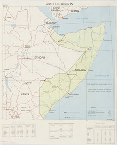 Beechworth RSL Sub-Branch
Map - Map Somalia Region, 1992
This map was used for briefing purpose only as the relief data is incomplete. Double sided coloured paper map of the Somalia Region with a 1:2 250 000 scale. Display side - PRODUCED AND PRINTED BY / 1 TOPO SVV SQN / ROYAL AUSTRALIAN SURVEY CORPS / DECEMBER 1992 DEF/ARMY 20463 / -
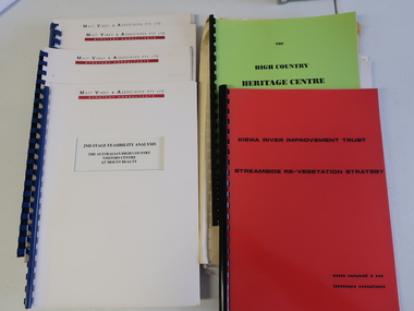 Kiewa Valley Historical Society
Collection of Papers and Books re - Mt Beauty Heritage Centre
In the early 1990s the KVHS applied for a grant to create the Mt Beauty Heritage Centre / Discovery Centre. This involved employing consultants and further research.This collection includes a lot of detail of the Kiewa Valley area.1. Bogong - The Alpine Discovery Centre 2. Heritage Centre - black folder 3. Heritage Centre - manila folder 4. High Country Heritage Centre - 1991 - green spiral folder 5. Six Heritage Centre - Matt Viney & Associates - white spiral folders 6. Landscape Consultants - Susan Campbell & son - red spiral folder 7. Plant List - Upper Kiewa Valley Water Supply Catchment 8. Geological Survey of Vic., Plates, Bulletin No. 44 - in battered paper 'bag' with front cover list of contents - 15 plates 9. Geological Survey - A3 photo copies of pages 106-117 10. Geological Survey of Vic. - Report of Progress No VII 1884 - bound book 11. Geological Survey of Vic. Bulletin 56 - includes nth east Vic. 1958 - bound book with green cloth spine 12. Department of Mines Report Vic. 1906 - booklet held with two staples 13. Royal Society of Vic book - The Geology of the Kiewa Area 1961 14. Miscellaneous papers - Geological Survey, Reports of Fossil Specimens and maps of local area 15. Gold - Appendix K and Appendix 111, Part C - photocopied pages from Vic Mining Registrars Report 1888 - manila foldermt beauty heritage centre, mt beauty discovery centre, geological surveys -
 Bendigo Military Museum
Photograph - Removal of Sequoia Californian Redwood Tree - Army Survey Regiment, Fortuna, Bendigo, 1994
These nine photographs of contractors felling a sequoia Californian redwood tree was taken at the Army Survey Regiment, Fortuna, Bendigo on the 16th of September 1994. Although 23 photos were taken at the time, 14 were not scanned due to their similarity to the nine featured photos. Two sequoia Californian redwood trees were planted at the front entrance of Fortuna Villa in the early days of gold mining magnate George Lansell’s occupation in the 1870’s. They were of immense proportion and much admired during the Lansell era and RA Svy’s occupation from 1942 to 1996. In these early days of Army occupation, the trees were lopped due to concerns of their size and proximity to the Villa. The felling of the tree in 1994 was considered unsafe due to perceptions of disease. These perceptions were upsetting to staff, as some believed that although there were a few dead branches, the tree was OK. As the tree had a noticeable lean, measurements were taken indicating the tree was stable. A sequoia sapling was eventually planted as a replacement to the diseased tree. It was decided to mill and store the timber of the felled tree on-site due to its historical significance. Although future uses were not determined at the time, the timber was eventually used to construct display cabinets and souvenir pens. When Defence decided to relocate geospatial production to a new facility in Junortoun an outer suburb of Bendigo in 2008, the sequoia timber was used as a beautiful feature in the front foyer as well as several feature walls within the building, providing a historical connection Fortuna Villa.This is a set of nine photographs of contractors felling a Sequoia (Californian redwood) tree at the Army Survey Regiment, Fortuna, Bendigo on the 16th of September 1994. The colour photographs were printed on photographic paper and are part of the Army Survey Regiment’s Collection. The photographs were scanned at 300 dpi. .1) - Photo, colour, 1994, Felling of sequoia Californian redwood tree. .2) - Photo, colour, 1994, Felling of sequoia Californian redwood tree. Neil Morgan (ground maintenance) is hugging the tree. .3) - Photo, colour, 1994, Felling of sequoia Californian redwood tree. .4) to .8) - Photo, colour, 1994, Felling of sequoia Californian redwood tree. .9) - Photo, colour, 1994, background on left - WO2 Bob Garritty, foreground L to R: Geoff (ground maintenance), unidentified, Neil Morgan (ground maintenance)..1P to .9P – No personnel are identified.royal australian survey corps, rasvy, army survey regiment, army svy regt, fortuna, asr -
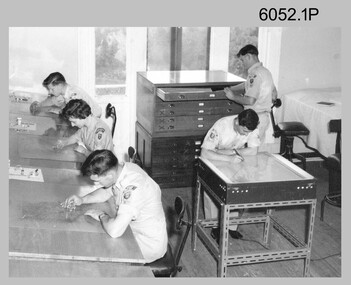 Bendigo Military Museum
Photograph - Scribing at the Army Survey Regiment, c1950s to 1979
These 10 photographs were taken over two decades from the late 1950s to 1979 at the Army Survey Regiment, Fortuna, Bendigo. The two photos taken in 1961 are annotated with named personnel and the date. The other photos are not annotated with dates, locations and names of personnel, although the technicians in the last three photos taken in 1979 are positively identified. The photos were most likely taken in the Ballroom, Ante Room and Attic, Cartographic Squadron’s main production rooms on the top floor of Fortuna Villa. Scribing was the cartographic process of drafting topographic features such as drainage, relief, vegetation, roads and culture on specially coated map reproduction material. The cartographic technician scribed out the map feature such as a creek to a specified line width on the map sheet, using a tool affixed with a metal or sapphire tipped cutter.This is a set of 10 photographs of technicians scribing topographic features at the Army Survey Regiment, Bendigo. The photographs were printed on photographic paper and are part of the Army Survey Regiment’s Collection. The photographs were scanned at 300 dpi. .1) - Photo, black & white, c1950s. unidentified personnel in Cartographic Squadron .2) - Photo, black & white, c1960s. unidentified personnel in Cartographic Squadron .3) - Photo, black & white, c1960s. unidentified personnel in Cartographic Squadron Attic .4) - Photo, black & white, c1960s. Cartographic Squadron Attic .5) - Photo, black & white, Oct 1961. L to R: PTE P. Carseldine, PTE H.S. Pasley, PTE C.A. Brown, WO2 M.A. McLaren, CPL Jennifer H. Murray. Cartographic Squadron .6) - Photo, black & white, Oct 1961. CPL Jennifer H. Murray. Cartographic Squadron .7) - Photo, black & white, 1979. SPR Mick Ellis in Cartographic Squadron .8) - Photo, black & white, 1979. SPR Mark Casey in Cartographic Squadron .9) - Photo, black & white, 1979. SPR Sharon (Jones) Treble in Cartographic Squadron .10) - Photo, black & white, 1961. PTE BJ Madex. Cartographic Squadron.1 to .4 - annotated “Scribing” .5 – annotated “Scribing PTE P. Carseldine, PTE H.S. Pasley, PTE C.A. Brown, WO2 M.A. McLaren, CPL Jennifer H. Murray. Oct 1961” .6 - annotated “Scribing CPL Jennifer H. Murray. Oct 1961” .7 to .9 - annotated “Scribing” .10 – annotated “PTE Madex Oct 61”royal australian survey corps, rasvy, army survey regiment, army svy regt, fortuna, asr, carto -
Bendigo Historical Society Inc.
Map - GREAT EXTENDED HUSTLER'S MINE - TRANSVERSE SECTION OF THE GREAT EXTENDED HUSTLER'S MINE
Transverse Section of the Great Extended Hustler's Mine on the Hustler's Line of Reef. Bulletin No 33, Plate No XII. Shows Poppet legs at the surface and Sill of Shaft at 788.99 feet above Sea Level, Cross Cuts and their depths, stone and geographical features encountered and their references and a number of enlarged drawing of sections of the cross cuts, Geological Survey of Victoria emblem and signed by H A Whitelaw, Underground Survey Office Bendigo, September 1913. The depths of crosscuts to No 21 were taken from plans of surveys by Mr Walker and Mr Craven, noted under Reference. Another note: This Saddle Reef is sketched from Mr Walker's plan. Dividends amounting to 360,000 pounds were obtained from it. This item has not been scanned or photographed.mining, parish map, great extended hustler's mine, transverse section of the great extended hustler's mine, old shaft, mr walker, mr craven, geological survey of victoria, underground survey office bendigo, h a whitelaw -
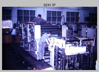 Bendigo Military Museum
Photograph - Print Troop Equipment and Personnel, Lithographic Squadron – Army Survey Regiment, Fortuna, Bendigo, c1970s to 1980s
This collection of nine photos was most likely taken in Lithographic Squadron, Army Survey Regiment, Fortuna, Bendigo, c1970s to 1980s. The two Ultra-MAN-III Printing Presses were made in Germany at a standard map size format and introduced in June 1962 as a two-colour offset press with improved safety features. With an upgrade to a third colour deck in 1968, productivity greatly improved as the two presses could print a five-colour standard topographic map in two passes, rather than the three passes before their upgrade. They were replaced with a single Heidelberg Speedmaster 102 five colour Printing Press in 1990. There is more information on the Ultra-MAN-III, Printing Press on page 71 of Valerie Lovejoy’s book 'Mapmakers of Fortuna – A history of the Army Survey Regiment’ ISBN: 0-646-42120-4. For additional photos, refer to item 6065.10P for Ultra-MAN-III presses. The Krause Wohlenberg in photo .5P was a heavy-duty guillotine to trim bulk printed map stock in the c1970s and c1980s. See item 6069.6P for more information and photos of guillotine equipment. Densitometer readings as shown in photo .6P were essential to the quality control of film and printing processes, reductions in time taken and material wastage.This is a set of nine photographs of Print Troop personnel and equipment from Lithographic Squadron at the Army Survey Regiment, Fortuna, Bendigo, c1970s to 1980s. The photographs are on 35mm colour slides and were scanned at 96 dpi. They are part of the Army Survey Regiment’s Collection. .1) - Photo, colour, c1970s, Ultra-MAN-III Printing Presses, L to R: unidentified technician, Laurie Sutton, SGT Jim Cook, unidentified technician. .2) - Photo, colour, c1970s, Ultra-MAN-III Printing Presses, unidentified technicians (x2). George Mann Fast Five Quad Demi Printing Press in background. .3) - Photo, colour, c1970s, Ultra-MAN-III Printing Presses, unidentified technicians (x2), George Austen in background and George Mann Fast Five Quad Demi Printing Press next to back wall. .4) - Photo, colour, c1970s, Ultra-MAN-III Printing Press, unidentified technicians (x2) operating George Mann Fast Five Quad Demi Printing Press in background. .5) - Photo, colour, c1970s, Krause Wohlenberg heavy-duty paper guillotine, unidentified technician. .6) - Photo, colour, c1970s, Densitometer reading taken by unidentified technician. .7) - Photo, colour, c1980s, Ultra-MAN-III Printing Presses, L to R: Janet Murray, Lance Strudwick, Terry Winzar, Komori Newkoni and Planeta Polygraph Printing Press in background. .8) to .9) - Photo, colour, c1980s, Ultra-MAN-III Printing Presses, Janet Murray, Komori Newkoni and Planeta Polygraph Printing Presses in background..1P to .9P - There are no annotations stored with the 35mm slides.royal australian survey corps, rasvy, army survey regiment, army svy regt, fortuna, asr, printing, litho -
Bendigo Historical Society Inc.
Map - HUSTLER'S ROYAL RESERVE NO 2 MINE - PLAN OF THE HUSTLER'S ROYAL RESERVE NO 2 MINE
Plan of the Hustler's Royal Reserve No 2 Mine on the Hustler's Line of Reefs Bulletin No 33, Plate No VI. Boundary of Leases No 8898 and 8897 shown. Various levels shown and some geographical features. Geological Survey of Victoria emblem. H . Harman, Director, W. Dickson, Secretary for Mines and The Hon. J. Drysdale Brown, Minister of Mines and signed by H Whitdon, Underground Survey Office, Bendigo, September 1913. This item has not been scanned or photographed.mining, parish map, hustler's royal reserve no 2 mine, plan of hustler's royal reserve no 2 mine, hustler's line of reefs, geological survey of victoria, h herman, w dickson, the hon j drysdale brown mlc, h whitdon