Showing 6940 items matching "view street"
-
 City of Greater Bendigo - Civic Collection
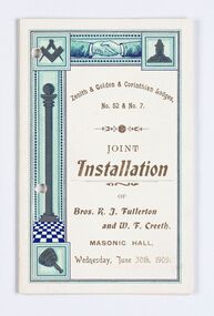
Memorabilia - Invitation and menu card, Joint Installation of Bros. K.J. Fullerton and W. F. Creeth, 1909
... position in View Street in 1866 with the intention of erecting... position in View Street in 1866 with the intention of erecting ...Freemasonary or Masonry has its beginnings in local guilds of stonemasons who from the end of 13th century regulated the qualification of stonemasons. Modern Freemasonry uses scriptures which include ritual practices and ethical conduct as part of its foundation and every member must profess a belief in a Supreme Being. Women are not allowed to be admitted and discussion of religion and politics is not to take place within the lodge. Freemasons meet in local Lodges which are supervised at a regional level by a Grand Lodge. The degrees of Freemasonry retain the three grades of medieval craft guilds, those of Entered Apprentice, Journeyman or fellow (now called Fellowcraft), and Master Mason. The candidate of these three degrees is progressively taught the meanings of the symbols of Freemasonry and entrusted with grips, signs, and words to signify to other members that he has been so initiated. The degrees are part allegorical morality play and part lecture. Candidates for Freemasonry will usually have met the most active members of the Lodge they are joining before being elected for initiation. (https://en.wikipedia.org/wiki/Freemasonry) The Golden Lodge of Sandhurst was established as the first Masonic Lodge in Bendigo in 1854. Many prominent men including City Councilors were lodge members at it was a popular way for men to socialise. As the masonic movement expanded further lodges were established in Bendigo and the surrounding Boroughs and Shires. The Golden and Corinthian Lodges purchasing two blocks of land in a prominent position in View Street in 1866 with the intention of erecting a new temple and after amalgamating in 1872 appointed architects Vahland and Getzschmann to design the building. The Bendigo Masonic Hall (now the Capital Theatre) was built in 1873 -74 for both public and private use and contained lodge rooms, a public tavern anda concert hall. The Masonic section occupied the northern side of the building at ground floor level and included a lodge room at the rear, a library and reading room, and other affiliated rooms. Walls of the entry hall and lodge room were decorated with classical columns and panels ornamented with Masonic emblems. The upper level of the building contained a large hall with balcony at the north end and removable stage at the south end. Elaborately decorated with Masonic emblems, this hall was used for Masonic purposes as well as being available to the wider community for social events. The tavern, which became known as the Masonic Hotel, occupied the basement and the ground floor of the southern side of the building and included a sitting room, parlours, billiard room, bedrooms, kitchen, cellars and servants' rooms. It appears that two public entrances were provided for this section, one directly from street level into the basement, the other from the public entry hall. Invitation for the Installation of two Lodge Brothers. Half fold design printed in gold, brown, light blue, dark blue and black ink on white card. Front and back cover decorated with masonic symbols. Menu listed inside. Front cover: Zenith & Golden Corinthian Lodges,/ No. 52 & No. 7./ Joint / Installation / of / Bros. K. J. Fullerton / and W. F Creeth / Masonic Hall / Wednesday, June 30th , 1909 bendigo masonic hall, capital theatre bendigo, milburn catering bendigo, making a nation exhibition, bendigo masonic lodge, city of greater bendigo events, city of greater bendigo community groups -
 City of Greater Bendigo - Civic Collection
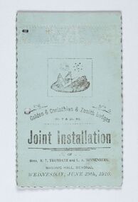
Memorabilia - Invitation and menu card, Joint Installation of Bros. R.T. Trembath and L. A. Sonnenberg, 1910
... position in View Street in 1866 with the intention of erecting... position in View Street in 1866 with the intention of erecting ...Freemasonary or Masonry has its beginnings in local guilds of stonemasons who from the end of 13th century regulated the qualification of stonemasons. Modern Freemasonry uses scriptures which include ritual practices and ethical conduct as part of its foundation and every member must profess a belief in a Supreme Being. Women are not allowed to be admitted and discussion of religion and politics is not to take place within the lodge. Freemasons meet in local Lodges which are supervised at a regional level by a Grand Lodge. The degrees of Freemasonry retain the three grades of medieval craft guilds, those of Entered Apprentice, Journeyman or fellow (now called Fellowcraft), and Master Mason. The candidate of these three degrees is progressively taught the meanings of the symbols of Freemasonry and entrusted with grips, signs, and words to signify to other members that he has been so initiated. The degrees are part allegorical morality play and part lecture. Candidates for Freemasonry will usually have met the most active members of the Lodge they are joining before being elected for initiation. (https://en.wikipedia.org/wiki/Freemasonry) The Golden Lodge of Sandhurst was established as the first Masonic Lodge in Bendigo in 1854. Many prominent men including City Councilors were lodge members at it was a popular way for men to socialise. As the masonic movement expanded further lodges were established in Bendigo and the surrounding Boroughs and Shires. The Golden and Corinthian Lodges purchasing two blocks of land in a prominent position in View Street in 1866 with the intention of erecting a new temple and after amalgamating in 1872 appointed architects Vahland and Getzschmann to design the building. The Bendigo Masonic Hall (now the Capital Theatre) was built in 1873 -74 for both public and private use and contained lodge rooms, a public tavern anda concert hall. The Masonic section occupied the northern side of the building at ground floor level and included a lodge room at the rear, a library and reading room, and other affiliated rooms. Walls of the entry hall and lodge room were decorated with classical columns and panels ornamented with Masonic emblems. The upper level of the building contained a large hall with balcony at the north end and removable stage at the south end. Elaborately decorated with Masonic emblems, this hall was used for Masonic purposes as well as being available to the wider community for social events. The tavern, which became known as the Masonic Hotel, occupied the basement and the ground floor of the southern side of the building and included a sitting room, parlours, billiard room, bedrooms, kitchen, cellars and servants' rooms. It appears that two public entrances were provided for this section, one directly from street level into the basement, the other from the public entry hall. Invitation for the Installation of two Lodge Brothers. Horizontal fold printed in black ink on blue card. Embossed cover with scalloped edging. Front and back cover decorated with masonic symbols. Menu listed inside. Front cover: golden & Corinthian & Zenith Lodges / No. 7 and Mo. 52 / joint Installation / of / Bros, R. T. Trembath and L. A. Sonnenber / Masonic Hall, Bendigo / Wednesday, June 29th, 1910. bendigo masonic hall, capital theatre bendigo, milburn catering bendigo, brockley printers bendigo, making a nation exhibition, bendigo masonic lodge, city of greater bendigo community groups, city of greater bendigo events -
 City of Greater Bendigo - Civic Collection
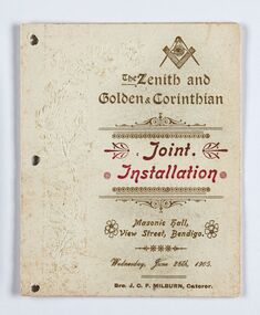
Memorabilia - Invitation and Menu Card, Joint Installation, 1905
... position in View Street in 1866 with the intention of erecting... position in View Street in 1866 with the intention of erecting ...Freemasonary or Masonry has its beginning in local guilds of stonemasons which from the end of 13th century regulated the qualification of stonemasons. Modern Freemasonry uses scriptures which include ritual practices and ethical conduct as part of its foundation and every member must profess a belief in a Supreme Being. Women are not allowed to be admitted and discussion of religion and politics is not to take place within the lodge. Freemasons meet in local Lodges which are supervised at a regional level by a Grand Lodge. The degrees of Freemasonry retain the three grades of medieval craft guilds, those of Entered Apprentice, Journeyman or fellow (now called Fellowcraft), and Master Mason. The candidate of these three degrees is progressively taught the meanings of the symbols of Freemasonry and entrusted with grips, signs, and words to signify to other members that he has been so initiated. The degrees are part allegorical morality play and part lecture. Candidates for Freemasonry will usually have met the most active members of the Lodge they are joining before being elected for initiation. (https://en.wikipedia.org/wiki/Freemasonry) The Golden Lodge of Sandhurst was established as the first Masonic Lodge in Bendigo in 1854. Many prominent men including City Councilors were lodge members at it was a popular way for men to socialise. As the masonic movement expanded further lodges were established in Bendigo and the surrounding Boroughs and Shires. The Golden and Corinthian Lodges purchasing two blocks of land in a prominent position in View Street in 1866 with the intention of erecting a new temple and after amalgamating in 1872 appointed architects Vahland and Getzschmann to design the building. The Bendigo Masonic Hall (now the Capital Theatre) was built in 1873 -74 for both public and private use and contained lodge rooms, a public tavern anda concert hall. The Masonic section occupied the northern side of the building at ground floor level and included a lodge room at the rear, a library and reading room, and other affiliated rooms. Walls of the entry hall and lodge room were decorated with classical columns and panels ornamented with Masonic emblems. The upper level of the building contained a large hall with balcony at the north end and removable stage at the south end. Elaborately decorated with Masonic emblems, this hall was used for Masonic purposes as well as being available to the wider community for social events. The tavern, which became known as the Masonic Hotel, occupied the basement and the ground floor of the southern side of the building and included a sitting room, parlours, billiard room, bedrooms, kitchen, cellars and servants' rooms. It appears that two public entrances were provided for this section, one directly from street level into the basement, the other from the public entry hall. Invitation for the Installation of unnamed Brothers. Half fold printed in gold and red ink on cream coloured card. Embossed cover with plain edging. Front and back cover decorated with masonic symbols. Menu listed inside. Front cover: The Zenith and Golden and Corinthian Lodges ? Joint Installation / Masonic Hall, Bendigo / Wednesday, June 28th, 1905 / Bro J.O.R Milburn Caterer bendigo masonic hall, capital theatre bendigo, milburn catering bendigo, making a nation exhibition, james printer eaglehawk, bendigo masonic lodge, city of greater bendigo community groups -
 City of Greater Bendigo - Civic Collection
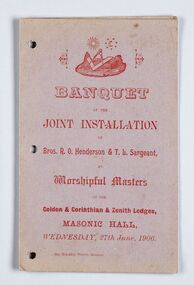
Memorabilia - Invitation, Joint Installation of Bros. R.O. Henderson & T. L. Sargeant, 1906
... position in View Street in 1866 with the intention of erecting... position in View Street in 1866 with the intention of erecting ...Freemasonary or Masonry has its beginnings in local guilds of stonemasons who from the end of 13th century regulated the qualification of stonemasons. Modern Freemasonry uses scriptures which include ritual practices and ethical conduct as part of its foundation and every member must profess a belief in a Supreme Being. Women are not allowed to be admitted and discussion of religion and politics is not to take place within the lodge. Freemasons meet in local Lodges which are supervised at a regional level by a Grand Lodge. The degrees of Freemasonry retain the three grades of medieval craft guilds, those of Entered Apprentice, Journeyman or fellow (now called Fellowcraft), and Master Mason. The candidate of these three degrees is progressively taught the meanings of the symbols of Freemasonry and entrusted with grips, signs, and words to signify to other members that he has been so initiated. The degrees are part allegorical morality play and part lecture. Candidates for Freemasonry will usually have met the most active members of the Lodge they are joining before being elected for initiation. (https://en.wikipedia.org/wiki/Freemasonry) The Golden Lodge of Sandhurst was established as the first Masonic Lodge in Bendigo in 1854. Many prominent men including City Councilors were lodge members at it was a popular way for men to socialise. As the masonic movement expanded further lodges were established in Bendigo and the surrounding Boroughs and Shires. The Golden and Corinthian Lodges purchasing two blocks of land in a prominent position in View Street in 1866 with the intention of erecting a new temple and after amalgamating in 1872 appointed architects Vahland and Getzschmann to design the building. The Bendigo Masonic Hall (now the Capital Theatre) was built in 1873 -74 for both public and private use and contained lodge rooms, a public tavern anda concert hall. The Masonic section occupied the northern side of the building at ground floor level and included a lodge room at the rear, a library and reading room, and other affiliated rooms. Walls of the entry hall and lodge room were decorated with classical columns and panels ornamented with Masonic emblems. The upper level of the building contained a large hall with balcony at the north end and removable stage at the south end. Elaborately decorated with Masonic emblems, this hall was used for Masonic purposes as well as being available to the wider community for social events. The tavern, which became known as the Masonic Hotel, occupied the basement and the ground floor of the southern side of the building and included a sitting room, parlours, billiard room, bedrooms, kitchen, cellars and servants' rooms. It appears that two public entrances were provided for this section, one directly from street level into the basement, the other from the public entry hall. Invitation for the Installation of Brothers Henderson and Sargeant. Half fold printed in red ink on grey / mauve coloured card with plain edging. Menu listed inside on left, toasts listed on inside right. Front cover: Banquet / at the / Joint Installation / of / Brox, R. O Henderson & T. L. Sargeant / as / Worshipful Masters / of the / Golden and Corinthian & Zenith Lodges / Masonic Hall / Wednesday, 27th June 1906 bendigo masonic hall, capital theatre bendigo, milburn catering bendigo, making a nation exhibition, brockley printers bendigo, bendigo masonic lodge, city of greater bendigo community groups -
 City of Greater Bendigo - Civic Collection
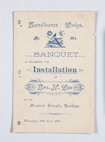
Memorabilia - Invitation, Joint Installation of Bros. H. Lee, 1907
... position in View Street in 1866 with the intention of erecting... position in View Street in 1866 with the intention of erecting ...Freemasonary or Masonry has its beginnings in local guilds of stonemasons who from the end of 13th century regulated the qualification of stonemasons. Modern Freemasonry uses scriptures which include ritual practices and ethical conduct as part of its foundation and every member must profess a belief in a Supreme Being. Women are not allowed to be admitted and discussion of religion and politics is not to take place within the lodge. Freemasons meet in local Lodges which are supervised at a regional level by a Grand Lodge. The degrees of Freemasonry retain the three grades of medieval craft guilds, those of Entered Apprentice, Journeyman or fellow (now called Fellowcraft), and Master Mason. The candidate of these three degrees is progressively taught the meanings of the symbols of Freemasonry and entrusted with grips, signs, and words to signify to other members that he has been so initiated. The degrees are part allegorical morality play and part lecture. Candidates for Freemasonry will usually have met the most active members of the Lodge they are joining before being elected for initiation. (https://en.wikipedia.org/wiki/Freemasonry) The Golden Lodge of Sandhurst was established as the first Masonic Lodge in Bendigo in 1854. Many prominent men including City Councilors were lodge members at it was a popular way for men to socialise. As the masonic movement expanded further lodges were established in Bendigo and the surrounding Boroughs and Shires. The Golden and Corinthian Lodges purchasing two blocks of land in a prominent position in View Street in 1866 with the intention of erecting a new temple and after amalgamating in 1872 appointed architects Vahland and Getzschmann to design the building. The Bendigo Masonic Hall (now the Capital Theatre) was built in 1873 -74 for both public and private use and contained lodge rooms, a public tavern anda concert hall. The Masonic section occupied the northern side of the building at ground floor level and included a lodge room at the rear, a library and reading room, and other affiliated rooms. Walls of the entry hall and lodge room were decorated with classical columns and panels ornamented with Masonic emblems. The upper level of the building contained a large hall with balcony at the north end and removable stage at the south end. Elaborately decorated with Masonic emblems, this hall was used for Masonic purposes as well as being available to the wider community for social events. The tavern, which became known as the Masonic Hotel, occupied the basement and the ground floor of the southern side of the building and included a sitting room, parlours, billiard room, bedrooms, kitchen, cellars and servants' rooms. It appears that two public entrances were provided for this section, one directly from street level into the basement, the other from the public entry hall. Invitation for the Installation of Brother Lee. Half fold printed in blue ink on cream coloured card with plain edging. Menu listed inside on left, toasts listed on inside right, officers listed on back cover. Front cover: Sandhurst Lodge / No 194 / Banquet / to celebrate the / Installation / of / Brother H. Lee / in the / Masonic Temple, Bendigo / Thursday, 20th June 1907 bendigo masonic hall, capital theatre bendigo, milburn catering bendigo, making a nation exhibition, bendigo masonic lodge, city of greater bendigo events, city of greater bendigo community groups -
 Melbourne Tram Museum
Postcard - Set of 6 mounted cable tram postcards, 1910s
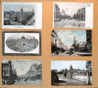
... - General view of Collins Street Melbourne - from Spring St looking... to bottom: 1 - Town Hall Melbourne - damaged paper 2 - General view ...Postcards, all featuring the cable tram era, left to right, top to bottom: 1 - Town Hall Melbourne - damaged paper 2 - General view of Collins Street Melbourne - from Spring St looking west 3 - Central Railway Station, Melbourne - the principal building is complete though the roof along Swanston St over the other platforms is yet to be completed. 4 - Bourke St Melbourne - looking west from Swanston St - has the Wertheim and Roberts Stores in the view along with the post office. 5 - Bourke St Melbourne - looking east from Swanston St with Morells Orient Hotel and the Royal Mail Hotel on the two corners 6 - Melbourne from St Kilda Road.Demonstrates a set of 6 postcards featuring Melbourne cable trams.Set of 6 cable tram postcards mounted on to light weight boardtramways, flinders st station, swanston st, bourke st, collins st, st kilda road -
 Stawell Historical Society Inc
Photograph, Houses in Houston Street -- 4 Photos
... building with faded grey? roof. 225c a view of houston street... with faded grey? roof. 225c a view of houston street lloking ...Houston St. & Houses. Series of 4 photosFour Colour Photgraphs 225 of a brick building with a palm tree in front. a white car in the front on the left. 38 Houston Street 225a - white brick house with arched verandah, and tiled roof. M.T. White 42Houston Street. 225b - Withe Wetherboard miners cottage, wiith red corregated roof. next to a similar building with faded grey? roof. 225c a view of houston street lloking westtoward the Grampians 225d - A house light brow in colour with two chimneys and an upper window with shutters, low brick fence topped with arched iron railings gateway covered with an archway with tiled topstawell houses -
 Ballarat Tramway Museum
Photograph - Digital image, Murray Views, Murray Views No. 31 Sturt Street Ballarat Vic, c1950
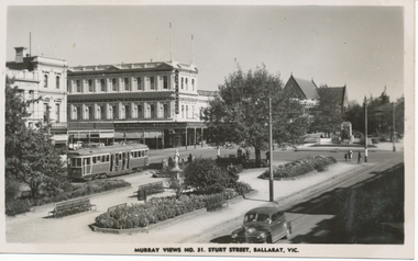
... and white postcard, titled "Murray Views No. 31, Sturt Street..., titled "Murray Views No. 31, Sturt Street Ballarat Vic" , photo ...Yields information the appearance of Sturt St and Doveton about 1950 with an SEC bogie tram in the photograph.Digital image from the Wal Jack Ballarat Album of a black and white postcard, titled "Murray Views No. 31, Sturt Street Ballarat Vic" , photo looking south west at corner of Doveton and Sturt St with the Harry Davies store in the background. Bogie tram No. 22 is outbound in the street. Has many people in the median strip. Photo c1950. Published by Murray Views, Gympie Queensland - real photo. For rear of postcard - see image i2.trams, tramways, sturt st, doveton st, tram 22 -
 Linton and District Historical Society Inc
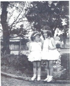
Photograph, Elizabeth Lock and Nanette Hunt, circa 1937
... is not shown - the view is across Sussex Street to a cottage... is not shown - the view is across Sussex Street to a cottage ...The girls are Elizabeth Lock and Nanette Hunt. The photograph was taken in the garden at the former Donaldson family home in Sussex Street, Linton. Unfortunately, the house is not shown - the view is across Sussex Street to a cottage on the other side of the road. Elizabeth Lock's aunt and uncle, Vera and James Johnson, bought the house from the Donaldson family in the mid 1930s. Elizabeth Lock, b.1934, often stayed for extended periods with her aunt and uncle and briefly attended school at Linton in 1941. Nanette Hunt, b.1931, was the daughter of William George Hunt, Postmaster at Linton in the 1930s.Black and white copy of original photograph which shows two small girls dressed in fairy or butterfly costumes. They are standing underneath trees in a garden. A cottage with a verandah can be seen in the background.On reverse: "L - Beth Watson, age 3 / R - Nanette Hunt / (Post Master's daughter) / Front garden, / Dr. Donaldson's / circa 1937".elizabeth lock, nanette hunt -
 Bendigo Historical Society Inc.
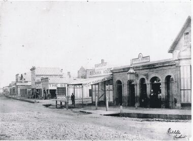
Photograph - CHARING CROSS/FOREST STREET: BENDIGO, 1860's
... St. is High St. Roadway to right of Forest Street is View... to right of Forest Street is View Place. . On back 'Batchelder ...Black and white photo: copy. Streetscape at Charing Cross - side street is Forest Street, roadway to left of Forest St. is High St. Roadway to right of Forest Street is View Place. . On back 'Batchelder, Sandhurst, lower RH of image, in grey lead top RH on back No. 7 ' Busineses include J.B.Loridan steam chaff mills Hay & Corn Store The Benndigo Tin Shop Forest Street R.Bentley & Co Britannia House Royal Hotel Batchelder PhotoBatchelder Sandhurstplace, streetscape -
 Bendigo Historical Society Inc.
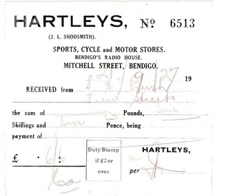
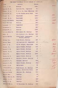
Document - BUSH COLLECTION: BUSINESS ACCOUNTS AND RECEIPTS, 1920 - 1930
... Commissioners, wood carting H.J. Fraser, A.N.A. building, View Street... H.J. Fraser, A.N.A. building, View Street, Bendigo R.O ...Collection of approximately 74 accounts, 1925 - 1928, and receipts issued to S. A. Bush from various businesses in Bairnsdale and Bendigo. Invoices from: Hartleys, Mitchell Street, Bendigo. W. Rasmussen, for wood Bendigo Timber Co., Mollison Street and Williamson St. J. Kitchen & Sons Limited, Candle and soap manufacturers Stilwells, House furnishers, William Lunn, Painter, Pall Mall, Bendigo.Hargreaves Street, Bendigo W. McWiliams, wood merchant, 15 Milroy Street, Bendigo. Victorian Railways Commissioners, wood carting H.J. Fraser, A.N.A. building, View Street, Bendigo R.O Henderson, Beehive Pty Ltd., Pall Mall, Bendigo F.C. Cross, Furnishing, Andrew's Building, Hargreaves Street, Bendigo. Albert Bush's Produce Stores, Chaff Mills, Williamson Street, Bendigo. Bendigo Timber Coy. Mollison Street, Bendigo Buckell & Jeffrey, Railway Station, Bendigo C. Button, Carrier, 204 William Street, Bendigo. Furniture packed and stored. (invoice has photo of canvas covered cart. Written on side of cart' Furniture Packed and Stored, The Big Button' . ) W. Irving, House furnishing, 211 Mitchell Street, Bendigo Hartley's Bendigo, Len Shoosmith W. Koska, 297 Williamson Street Albert Bush's Stores, (next St. Paul's Tower) Williamson Street, Bendigo. W.J. Knight, Waggon and Lorry Builder, William Street, Bendigo William Lunn, Bendigo Glass, Pall Mall, Bendigo. Sandhurst and Northern District Trustees, Bendigo Cockings, Drapers, Pall Mall, Bendigo A. Fraser, 178 Carpenter Street, Bendigo W. Irving, furniture store, 211 Mitchell Street, Bendigo Myers, Pall Mall, Bendigo R.C. Eagle, wood merchant, Barnard Street, Bendigo W. McWilliams, wood merchant. W.H Osborn & Co., 130 Williamson Street, Bendigo Campbell & Connelly & Co., High Street, Bendigo H. McWilliams, cartage contractor, 15 Mitchell (?) Street Bendigo. H. Gray, 257 Barnard Street, Bendigo (Singer Sewing Machines) J.D. Allen, 'Whitehall" Sorrento (accommodation 4 weeks) W. McWilliams, for soil and sand.person, individual, bush collection - personal -
 Bendigo Historical Society Inc.
Administrative record - Great Columbian Mining Company Minute Book 1904-1911, 1906
... of Victoria, View Street, Bendigo to 'wind up' the Great Columbian... Allen, Manager, Bank of Victoria, View Street, Bendigo to 'wind ...Dark green hardcover register, buff binding on spine and corners, two hundred and seventy pages. 'Minute Book' written in gold print on spine of book. Written in blue pen on inside front page: ' The Great Columbian Mining Company No Liability' Minutes entered date from 30th March 1904 to 6th September 1911. Minutes signed by James Hedley. Documents inserted in minute book, additional to minute content: 1. List of unpresented cheques (no date on list) 2. Petition by John William Allen, Manager, Bank of Victoria, View Street, Bendigo to 'wind up' the Great Columbian Mining Co. Dated 18th September, 1911. 3. From Great Columbian Mining Co., Inglewood, Butler and Sons account 4. List of Great Columbian Mining Company N.L. shareholders 5. Mine Manager's Report half year ending 6th September 1911 6. Directors' Report, 6th September 1911 7. Two letters from Fred. Douglas Jones, Barrister and Solicitor, Albion Chambers, Bendigo regarding cheques 'being returned unpaid' by Bank 8. Judgement from County Court Bendigo, 19th September, 1911, against the Great Columbian Mining Company, defendant. Plaintiffs, George Victor Lansell; George Wooten Lansell and Richard Hartley Smith Abbott 9. McColl and Rankin, Legal Managers, Accountants, invoice to Great Columbian Mining Co., 31st December 1911. 10. Letter, J. Stagg, Inglewood to McColl and Rankin, re settling up of accounts for the Great Columbian Mining Co., Inglewood 11. Great Columbian liquidation, Ingleoowd, Feb 19th. 1912 to R.A. Rankin Esq., re sale catalogue articles. Enclosed Mr. Butters charge for hire of horse and dray ((not in book) Signed J. Cavanaugh 12. Invoice from McColl and Rankin to the Great Columbian Co., for cash advances, 31st December 1912 13. Great Columbian Mining Co., statement of having received 'one receiver and mountings in good condition' signed McCulloch Carrying co., L. Lee, 5/2/12 14. Account Richard Linton, Manufacturers Agent, Queen Bridge Square, Melbourne to Great Columbian Mining Co., Inglewoodbendigo, mccoll and rankin, margaret roberts, great columbian mining company, inglewood, -
 Eltham District Historical Society Inc
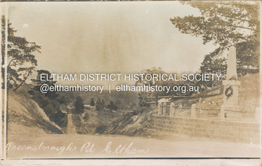
Postcard - Photograph postcard, Greensborough Road, Eltham, c.1925
... Rare postcard showing view looking down Bridge Street... melbourne Rare postcard showing view looking down Bridge Street ...Rare postcard showing view looking down Bridge Street with the Eltham Obelisk in situ in its original location. The Obelisk War Memorial was unveiled 3 August 1919. Subsequent to the unveiling provision was made of a stone retaining wall topped with a chain link and granite stone boundary. Along with the use of the name Obelisk Corner, the Bridge Street bridge was also known as Obelisk Bridge. The Obelisk was relocated to the fornt garden of the Eltham RSL sub-branch in the mid 1950s as a result of road widening and corner improvements. The Bridge Street Bridge was replaced with a new concrete bridge in 1956-1957.Digital file only Postcards scanned from the collection of Michael Aitken on loan to EDHS, 2 Sep. 2022michael aitken collection, eltham, postcards, bridge street, bridge street bridge, obelisk, obelisk corner, eltham cenotaph, eltham obelisk, war memorial, main road -
 Stawell Historical Society Inc
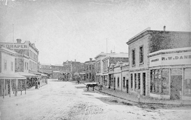
Photograph, Main Street Stawell looking West from Layzell Street 1878
... Street. D. Fern Hotel / Times Office, McKeller Building... Australia, R.W, Dane Grocer on corner of Layzell Street. Same view ...1878 photo of Main St. Scenes looking West from Layzell St. Wooden building on left is Foresters Hotel on corner of Patrick Street. D. Fern Hotel / Times Office, McKeller Building with Draper sign. Across Main street from left in distance is J Allingham Draper, Chadwick & Co Drapers / Liddiard's , D. Telford Produce Grocer, Bank of Victoria, Oriental Bank / O'Driscoll's, J. Punchard Furniture, A.B. Clemes, Bennett & Briston, Union Bank Australia, R.W, Dane Grocer on corner of Layzell Street. Same view as 6730-2 0539-2 Victorian Views. C. Herbert, Photo. Stawell 1878stawell businesses streetscape -
 Glenelg Shire Council Cultural Collection
Photograph - Sheet of 12 contact prints - Various historic Portland buildings and Landmarks, c. 1970
... ) Portland Show (g) North side Julia Street looking west Bank...) Portland Show (h) Henty Street, Portland (i) (B) Sheet of 12 ...Sheet of 12 contact prints of rephotographed photographs. Measurements (a) (e)-(h) (j-i)(b) 3.7 x 55 x 3.7 Framed 5.2 x 44.5 x 4 (a) Looking south across beach at Dutton Way (b) S.S. 'Eumeralla' (c) Construction of railway pier (d) Jackass Fern Gully (e) 'Kingsley' (f) Portland Show (g) North side Julia Street looking west Bank of Australiasia (h) Henty Street looking east from Percy Street (i) Old Post Office (j) All Saints Catholic Church (k) View from Henty Street - old Town Hall (l) Opening 3rd BathsFront: (a) 'Dutton Way 1900 (b) 'S.S. Eumeralla' (c) Construction of Railway Pier (f) Portland Show (h) Henty Street, Portland (i) (B) -
 Kew Historical Society Inc
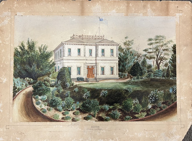
Work on paper, Madford: the property of A.S. King Esq
... and plants of the garden facing Wellington Street. The view selected... of the garden facing Wellington Street. The view selected is the south ...The Victorian-era mansion Madford in Wellington Street had several incarnations before it was finally demolished. While the precise details of its original construction have not been discovered, we know that it was originally named Elm Lodge, and that the property was offered for sale in 1863 by Thomas Mitchell, of the firm Mitchell & Bonneau, wholesale ironmongers and merchants. The house was sold in about 1873 to William Siddeley (1827-1905), who was described on the occasion of his death as ‘the father of Australian shipping’. The next owner was Arthur Septimus King (1827- 99), who renamed the house Madford after his purchase of the property in 1875. It was A.S. King for whom this artwork was completed. Following King’s death in 1899, portions of the property were sold, including to the Borough of Kew in 1905, to form the Alexandra Gardens. Then, in 1920, the house and its remaining lands were sold to the Catholic Church who opened St Anthony’s Home for Children on the site in 1922. That building was promptly demolished, and the site redeveloped circa 1976.Gift of James Pearson, 2022This fine perspective drawing of the architectural elements of Madford [formerly Elm Lodge, later St Anthony's Home for Babies] is contrasted with the freer addition in watercolour of the layout and plants of the garden facing Wellington Street. The view selected is the south-facing main facade and the west facing side. After A.S. King purchased the house in 1875, it was extended with new wings at the rear to accommodate his large family. There is no indication of these extensions in the painting so its creation must predate the renovations, and probably depicts the original building on the site."MADFORD / The Property of A. S. KING Esq"elm lodge, madford, st anthony's home for babies, houses -- wellington street -- kew (vic.), thomas mitchell, william siddeley, arthur septimus king -
 Bendigo Historical Society Inc.
Document - HISTORY OF BENDIGO PERFORMING ARTS 1870-1963, 1870-1963
... Bank Theatre BRAC View Street Bendigo. Negative of The Bendigo... Inc. History House 11 Mackenzie Street Bendigo goldfields ...History of Bendigo Performing Arts 1870 - 1963. Presented by Charles Murray Bendigo Historical Society Inc. (13 pages,paper clipped). Performers and Palaces November 24, 2000 at the Bendigo Bank Theatre BRAC View Street Bendigo. Negative of The Bendigo Liedertafel in Opera, the performance of 'Pinafore' in 1888. Names of the cast(negative) are: Back row - Miss A Gellmiek(Josephine), Mr F. Macoboy(Ralph Rackstraw), Miss Forsyth(Hebe), Mr. M. Macoboy (Sir Joseph Porter), Miss E. O'Flaherty (Little Buttercap), Mr. L. Germann(Captain Corcoran). Front Row: - Mr. C,. Pallett (Bill Bobstay), Mr. H. Monaghan(Conductor), Dr. Penfold (president), Mr. H. M. Marks(Stage manager), Mr. A. Tawse (Dick Deadeye). The Bendigo Lieddertafel waqs extablished in 1884 by MNr. A. T. Crook. Mr. William Brown, the well known solicitor, took and active part along with his brother, Mr. T. Brown, in its inauguration. Mr. W. Brown always took a warm interest in matters musical, and for many years was one of the most prominent singers in the district. Contemporary with him in the sixties were Mrs. Betham and Mrs. Ellis, and in the seventies, Mrs. E. E. Casey. Negative of halla's Premier City Band. Standing ,from left to right - H. Middleton, T. Ash, J. Graham, G. Foster, W. Hicks, S. Mauley, J. Eaton, V. Byrne (Drum Major), - Sullivan, R. Lindsay, C. Crawford, R. Meakin, D. Westphalen, W. Hall, G. Hunter, B. Broadbent, W. Higginbotham. Sitting, from left to right - T. Sayer, R. E. Crawford, C. Foster, J. Mappin, G. Meakin, G. Coleman, F. Lindsay, Nat. Hallas (Bandmaster), J. Swift, C. Anderson, J. Armstrong, W. Mappin (at back), I. Moore (in front), W. Bannister, J. Whitlam, J. Daley, Bert Daley. Negative of Mr. W. J. Dillon as 'Hamlet'. Negative of Mr. Tone and Mr. Nalder, The Grave Diggers in 'Hamlet'. Negative of Amy Castle. Negative of Mr. E. A. Bindley, Conductor. Negative of miss Pauline Bindley as Hamletta. Negative from 'Boccoccio' 1909. Mr M. Gallagher (Lotteringhi), Mr. G. Brayshaw (Scalza), Mr. A. E. Sayer (Lambertuccio). Negative of Kob Samuels.bendigo, tourism, theatre history 1870-1963 -
 Eltham District Historical Society Inc
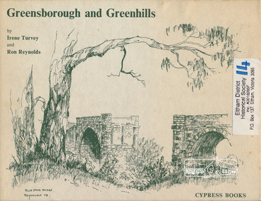
Book, Irene Turvey et al, Greensborough and Greenhills / words by Irene Turvey ; Drawings by Ron Reynolds, 1973
... - 49 Grimshaw Street, View of Greensborough (from Delphin... - 49 Grimshaw Street, View of Greensborough (from Delphin ...Pen and ink sketches accompanied by appropriate text in double page spreads. Contents cover : Blue stone bridge, Introduction, House cnr Church and Hailes Street, House - 25 Hailes Street, Yandell Reserve, Greensborough Hotel, Lobb's Kiosk, House - 49 Grimshaw Street, View of Greensborough (from Delphin Crescent), Railway Station, Old Barn (near Greensborough Railway Station), Partington's Flat and River Valley, Rand Street Bridge, Lower Main Street, Greenbriar Nursery, Hitching rail, Ashmead - Dr Cordner's Home, Greensborough Primary School, House - cnr St Helena and Diamond Creek Raods, Sondermeyer's Hill, Methodist Church, Football Pavilion, Cemetery, St Katherine's Church, St. Helena, Civic Centre, Briar Hill Timber Mill, 24 River Street, Kelly's Garden Supplies, 158 Main Street, Old Swimming pool, 105 Main Street.Hardback; 62 p. : ill., map ; 19 x 25 cm.ISBN 0909807108 Signed by author and illustrator Two copiesgreenhills, greensborough -
 Bendigo Historical Society Inc.
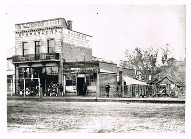
Photograph - WES HARRY COLLECTION: H.& C. HOLMES, IRONMONGERS
... Black and white reproduction: street scape view showing two... Inc. History House 11 Mackenzie Street Bendigo goldfields ...Black and white reproduction: street scape view showing two storey building, ornate wrought iron balcony. On side of building : H. & C. Holmes, ironmongers & iron merchants, agricultural implements, oils, paints & paperhangings. Single storey building on RH side, timber above single doorway, paned windows either side. On front 'Bendigo rifle caller' (?) Dirt road at front, four men standing on footpath. Wooden fence on right hand side, small chimney behind. Batchelder written on bottom right hand side.Batcheldercottage, miners, bendigo, sandhurst, h. & c. holmes, ironmongers, agricultural, rifle -
Port Melbourne Historical & Preservation Society
Photograph - Bay Street, Sandridge, 1870s
... View southeast in Bay Street from roof of building on north... on upper left face of photo View southeast in Bay Street from roof ...Photographed in 1872 by William PATERSON as one of a series for the Melbourne Exhibition of 1873; original mount hanging in Engineering Department at Port Melbourne Town Hall at 19-9-1994 but now in Port Phillip,City Collection. This set of original prints belonged to Town Clerk Syd ANDERSON, then to his daughter-in-law Phyllis ANDERSON (donor). Accompanied by list of captions, both hand written and typed (the latter a partial listing).View southeast in Bay Street from roof of building on north west corner of Bay and Liardet Streets c1871. Includes hotel identified in caption as "Foundry" on opposite corner (if captions were written in the 1920s the Port Theatre had already been constructed at this site, but there once was a 'Foundry' Hotel on that corner*); ginger beer/lemonade factory (Dawborns?) and pawnbroker; Graham Family Hotel can be seen in the distance at far left; also Holy Trinity (iron, with tower), Victorian Sugar Works, Post Office/Mail Exchange. Pre 1873 * '...try Hotel' visible?"P. Anderson" ink, on back:"11" in ballpoint on upper left face of photoindustry - manufacturing, business and traders - pawnbrokers, sydney sims anderson, town clerks, bay street, liardet street, foundry hotel, business and traders - hotels -
 Bendigo Historical Society Inc.
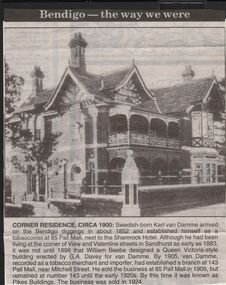
Newspaper - JENNY FOLEY COLLECTION: CORNER RESIDENCE CIRCA 1900
... had been living at the corner of View and Valentine streets... at the corner of View and Valentine streets in Sandhurst as early ...Bendigo Advertiser "The way we were" from 1999. Corner residence circa 1900: Swedish born Karl Van Damme arrived on the Bendigo diggings in about 1852 and established himself as a tobacconist at 85 Pall Mall, next to the Shamrock Hotel. Although he had been living at the corner of View and Valentine streets in Sandhurst as early as 1883 it was not until 1898 that William Beebe designed a Queen Victoria style building erected by G.A. Davey for Van Damme. By 1905, van Damme, recorded as a tobacco merchant and importer, had established a branch at 143 Pall Mall, near Mitchell street. He sold the business at 85 Pall Mall in 1909, but remained at number 143 until the early 1920s. By this time it was known as Pikes Buildings. The business was sold in 1924newspaper, bendigo advertiser, the way we were -
 Ringwood and District Historical Society
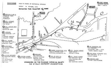
Pamphlet, Ringwood Walk - Points of Historical Interest, 1979
... crossing, railway station 10 - Station Street, views over railways... crossing, railway station 10 - Station Street, views over railways ...Sketch of walking route for 17 historical points of interest organised by the Ringwood Historical Society for St. Paul's Church Centenary Celebrations - 14 October 1979, estimated duration 2-1/4hours.1 - Start 2 - Cnr Braeside Avenue, old township, brickworks 1881-1916, Guests, Herrys, Hills 3 - Club Hotel, Ringwood Hall, 1st site of C of E church corner 4 - Ringwood Lake, Anthony Ford - pioneer 5 - Opposite Bardia Street, Sandy Gully, Duncan's Hotel 6 - Opposite Pratt Street, 2nd site of C of E, 2nd fire station, Bentleys, old shopping centre 7 - Warrandyte Road, Former Clocktower site, Pratts butcher shop, Bamfords 8 - End of Pitt Street, building viaduct 9 - Bedford Road, Webdales, old crossing, railway station 10 - Station Street, views over railways 11 - Station entrance, old shopping centre, 2nd Postoffice, 2nd blacksmiths, Mechanics Institute, Town Hall 12 - Clocktower, 3rd State School, coolstores, 3rd Postoffice, market, Kenworthys 13 - Opposite market, 3rd site of C of E, Ringwood views 14 - Adelaide Street, Dickens, 1st fire station, Ringwood Reserve 15 - Opposite squash courts, Matlocks, Salvation Army 16 - Opposite library, bowling club, old baths 17 - Outside C of E, Ringwood views, Brittens, Glamorgan -
 Eltham District Historical Society Inc
Photograph, Eltham Produce Store, Main Road, c.1960
... of Eltham Pioneers Photograph Collection No. 785 which is a view... of Eltham Pioneers Photograph Collection No. 785 which is a view ...Operated by John McLean and Son Situated just south from opposite Arthur Street, opposite the Eltham Village Shopping Centre. In 1974 the site was the location of the B.P Garage and opposite was the Woolworths Arcade. The Produce Store sold hay and grain. To the right was Garnet Burges' second hand scrap metal and bottles, then the blacksmith shop, which was later taken over by Garnet with second hand furniture and next door to that was Ray Staff's grocery store. The brick building has signage to promote Tanox Paint and Permoglaze products. This building was demolished by 1963 for the BP Evergreen Service Station. Photo taken at same time as Shire of Eltham Pioneers Photograph Collection No. 785 which is a view from near Arthur Street and Main Road intersection.Colour photograph copy of original photoshops, main road, eltham, eltham produce store, tanox paint, permaglaze, produce station, john mclean and son, garnet burges -
 Ballarat Tramway Museum
Postcard, Murray Views, Murray Views No. 20 - Sturt Street, Ballarat Vic.", c1955
... Postcard - black and white - titled Murray Views No. 20... Views No. 20 - Sturt Street, Ballarat Vic.", looking east from ...Yields information about the appearance of Sturt St in the early 1930's, tram operations, buildings and motor vehicles.Postcard - black and white - titled Murray Views No. 20 - Sturt Street, Ballarat Vic.", looking east from Doveton St with the Town Hall in the background. Tram 35 is westbound, showing Sebastopol. On the corner of Doveton and Sturt is the Sturt Hotel with an auction notice, next door is Palmdale Frocks, Stansfield and Smith, Coles, Homecrafts and Myer. Divided back postcard with details of the maker on the right hand side, MV symbol and a space for a stamp. btm7363bw - black and white version of the image used for the Long Gallery - 9/2021 2nd copy added 28-12-2021 - most likely a reproduction of the original as it does not have a postcard back.on rear of 2nd copy in ink "Ballarat No. In Sturt St, eastwards at" and Keith Kings stamp.trams, tramways, sturt st, doveton st -
 Ballarat Tramway Museum
Photograph - Digital image, W. J. Llewelyn, 6/03/1954 12:00:00 AM
... II to Ballarat 6/3/1954 by W. J. Llewelyn. .1 - Street... Elizabeth II to Ballarat 6/3/1954 by W. J. Llewelyn. .1 - Street ...Yields information about the Royal Visit to Ballarat and the tram decorated for its visit along with other arrangements.Set of three eight digital images taken of Queen Elizabeth II to Ballarat 6/3/1954 by W. J. Llewelyn. .1 - Street view of Sturt St looking East at St Patrick's church, with No. 38 in the background and the wooden crowd control barriers stacked by the footpath. .2 - Crowd waiting at the intersection of Sturt and Lydiard St. .3 - Crowd waiting in Sturt St, with soldier's, outside Myers Store .4 - Crowd and guard of honour waiting at the station. .5 - The Queen and Duke in the official car in Sturt St. .6 - ditto with Myer Store in the background. .7 - Scottish unit marching at the intersection of Bridge St and Grenville St with he Bucks Head Hotel in the background. Note the sign on the hotel pointing to the Floral Carpet at the Alfred Hall. .8 - Band at the City Oval. Date obtained from http://wiki.prov.vic.gov.au/index.php/Royal_Visit_1954,_Locations_for_Visiting_Municipalities,_Ballarat (accessed 11-6-2017)trams, tramways, civic functions, royal visit, railway station, lydiard st, sturt st, city oval, myers, tram 38 -
![Painting: Park Street [Adeney Avenue] Kew](/media/collectors/550653872162f11fb04854aa/items/5826877cd0cdd11284ad5413/item-media/614ac683a53a0756fd5e49da/item-fit-380x285.jpg) Kew Historical Society Inc
Kew Historical Society IncPainting, Park Street [Adeney Avenue] Kew, c. 1896
... of Parkhill Road and what was then Park Street, with views across... of Parkhill Road and what was then Park Street, with views across ...‘Adeney Avenue’ was the title given to this painting following its donation to the Kew Historical Society, yet the work’s origins predate the naming of Adeney Avenue in 1907 [originally gazetted as ‘Park Street’ (1865) and ‘Park Street South’ (1875).] Park Street ran between High Street and Parkhill Road beside what was later to become ‘Victoria Park’. This area was described in 1851 as “…a dense forest of gums and wattles which were to be largely cleared by 1888 after the naming of a recreation reserve”. The Reserve was still bisected by an unnamed creek in 1896, when the area was surveyed by the MMBW. The panoramic vista selected by the artist would appear to include ‘Eborensis’ (c.1895) on the corner of Parkhill Road and what was then Park Street, with views across cleared land towards the distant ranges. In the 19th century, north Kew was largely undeveloped farms stretching down to the Yarra. Oil on canvas by an unidentified artist of a panoramic view depicting what is now known as East Kew with mountains on the horizon. In the foreground is a two storey brick residence - Eborensis - located on the northeast corner of Parkhill Road and what is now Adeney Avenue. The view of the landscape and its rolling hills resulted from farming practices adopted following colonisation and settlement. Trees in the foreground and in the distance include remnant Eucalypts and introduced exotics.Label on rear of frame states "House on corner of Adeney Ave & Parkhill. [Regd. 254"]. Otherwise unsigned and undatedadeney avenue (kew), eborensis, park street (kew) -
 Bacchus Marsh & District Historical Society
Painting, View of Bacchus Marsh from Stamford Hill circa 1880s
... . In the foreground running horizontally Grant Street can be seen. The view.... In the foreground running horizontally Grant Street can be seen. The view ...The date of the scene depicted in this painting has not been identified. The painting has no artist signature or date. The view depicted is from an area close to the present day Madden Drive in Bacchus Marsh. The angle of the view suggests the artists viewpoint may have been from a spot close to the intersection of Madden Drive and Muir Street looking east over the town. Several buildings constructed in the 1860s and 1870s can be seen in the painting. These include Saint Andrews Presbyterian Church (now Uniting Church), built 1865, Stone Villa in Bennett Street, the Bacchus Marsh Court House, the former National Bank and the Border Inn, all on Main Street, and in the distance Saint Bernard’s Catholic Church. Buildings such as Simon’s Garage erected in 1913, on the corner of Main Street and Grant Street are not shown. In the foreground running horizontally Grant Street can be seen. The view of Grant Street shows very few buildings. One house in the centre of the picture is Murdoch's Cottage. A brick house constructed in 1868 on the corner of Grant Street and Waddell Street. To the right of the picture along Grant Street no buildings are shown. The store built by John Jory in 1890 at 60-62 Grant Street which survives as a building in 2025 is not shown. Some allowance for artistic interpretation must be allowed but based on what the scene depicts it suggests a scene of Bacchus Marsh in the late 1870s or 1880s. Print reproduction of an oil painting. Framed. Undated. Unsigned. BMDHS Location: AR/B12/Beside (on floor)views bacchus marsh vic., paintings bacchus marsh vic., landscapes bacchus marsh vic. -
 Bendigo Historical Society Inc.
Document - LONG GULLY HISTORY GROUP COLLECTION: CORNISH ASSOCIATION NEWSLETTER DECEMBER 2001
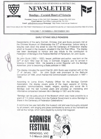
... down the street to view the Centenary of Federation display... at the Chinese Museum before taking a walk down the street to view ...Cornish Association of Bendigo & District Inc. Newsletter Volume 7: Number 4: December 2001. Titled Early Ethnic Gold Pioneers. Members met at the Chinese Museum before taking a walk down the street to view the Centenary of Federation display which is housed in the Museum, situated in the Old Post Office. Sir John Quick is also mentioned. According to Lorna Erwin, Publicity Officer for the Bendigo Cornish Association, the display covers some of the major aspects of mining, education, communications, health, religion, sporting and social life in Bendigo over the last 100 years and provides an interesting and informative comparison between life in Bendigo in 1901 and life today. Also mentioned is Bendigo can be proud of the Museum which was made possible by a grant from the Federal Government to allow Bendigo to share in the Centenary of Federation Celebrations.bendigo, history, long gully history group, the long gully history group - cornish association newsletter december 2001, cornish association of bendigo & district inc, george a ellis, eaglehawk fire statin, chinese museum, centenary of federation, old post office, sir john quick, bendigo advertiser, bathurst convention of 1896, commonwealth constitution 1897 - 1898, lorna erwin -
 Bendigo Military Museum
Postcard - POSTCARD, FARNHAM, U.K, Valentine's Series, cWW1
... with battlement. 4. Coloured street scene with buildings, horse drawn... with battlement. 4. Coloured street scene with buildings, horse drawn ...1. Florrie is a relative living in Farnham. 2. R.H. Baron married Elsie Keast in 1921. All cards relate to R.H. Baron's visits to Farnham whilst on leave to see Florrie. Part of the 'Robert H. Baron', no.3596 and Cooper Collection. See Catalogue No. 1981P for details of Baron's service.1. Coloured scene of a ruined castle and surrounding gardens. 2. Coloured scene of a garden with building and ruins in background. 3. Coloured photograph of a red brick building with battlement. 4. Coloured street scene with buildings, horse drawn transport and pedestrians. 5. Coloured photograph of the nave of a church looking towards the alter. 6. Coloured street scene with buildings and horse drawn transport. 7. Coloured view across a street to a white walled building with horse drawn transport. 8. Coloured photograph of a church, graveyard in foreground. 9. Black and white photograph of a castle surrounded by trees. 10. Black and white photograph of a forest scene with people standing on a bridge. 11. Black and white photograph of a street scene with buildings, horse drawn transport and people. 12. Black and white photograph of the tower of a church. Graveyard in the foreground. 13. Black and white photograph of a street scene with buildings, horse drawn transport and pedestrians. Castle on the hill in background. 14. Black and white photograph of a street scene with buildings, motor cars and pedestrians. 15. Black and white photograph of a street scene with buildings, motor cars, horse drawn transport and pedestrians. 16. Black and white photograph of a wooded valley. Houses on a hill in the background. 17. Black and white photograph of an avenue of trees. 18. Black and white photograph taken in a park. Three people standing on a bridge over a stream.1. The Keep, Farnham Castle. Handwritten in black ink on back: 'This is one of the pretty places around Farnham. I was all once here with Florrie. Bob' 2. In Castle grounds, Farnham. Handwritten in black ink on back: 'Dear Elsie, these are some places that visit... when I was down at Flories place. Bob xxxxxx' 3. Farnham Castle. 4. West Street, Farnham. 5. Parish Church, Farnham. 6. Castle Street, Farnham. 7. The Church House, Farnham. 8. Parish Church, Farnham. 9. Farnham Castle. 10. Red Hill Hanger, Farnham. Handwritten in black ink on back: 'Letter to R.H. Baron's sister - no date.' 11. South Street, Farnham. Handwritten in black ink on back: 'this part of the place I spent my leave at this is where Florrie is.' 12. Farnham Parish Church. Handwritten in black ink on back: 'Letter to R.H. Baron's mother - dated 24 July 1918.' 13. Castle Street, Farnham. Handwritten in black ink on back. 'I think you will know where this is as I have told you quite a lot about Farnham, it is where Florrie is. I spent my leave here. This is Castle Street and the castle is right on the top of the hill.' 14. Borough, Farnham. Handwritten in black ink on back. ' This is the place where Florrie lives. I spent my last leave their (sic), Bob.' 15. West Street, Farnham. Handwritten in pencil on back. 'Pte R.H. Baron, 57 Battalion, Australian Imperial Forces Abroad.' 16. Lower Bourne Valley, Farnham. Handwritten in black ink on back: 'Partial letter from R.H. Baron to his sweetheart.' 17. The Avenue, Farnham. Handwritten in black ink on back: 'Partial letter from R.H. Baron to his mother.' 18. Recreation Ground, Farnham. Handwritten in black ink on back: 'Letter to Doris from R.H. Baron - no date.' robert h. baron, cooper collection, postcards, farnham uk -
![View of Victoria Hill, Bendigo, taken from Old Chum Hill / [by] Nicholas Caire, circa 1876](/media/collectors/550653872162f11fb04854aa/items/577752a3d0cdd10a5c16e654/item-media/57775308d0cdd10a5c171c46/item-fit-380x285.jpg) Kew Historical Society Inc
Kew Historical Society IncPhotograph, Anglo-Australasian Photographic Company, View of Victoria Hill, Bendigo, taken from Old Chum Hill, c. 1876
... printed in ink on support l.c.: VIEW OF STURT STREET... the series was issued c. 1876 and reinforced a neo-Romantic view ...Nicholas Caire was born on Guernsey in the Channel Islands in 1837. He arrived in Adelaide with his parents in about 1860. In 1867, following photographic journeys in Gippsland, he opened a studio in Adelaide. From 1870 to 1876 he lived and worked in Talbot in Central Victoria. In 1876 he purchased T. F. Chuck's studios in the Royal Arcade Melbourne. In 1885, following the introduction of dry plate photography, he began a series of landscape series, which were commercially successful. As a photographer, he travelled extensively through Victoria, photographing places few of his contemporaries had previously seen. He died in 1918. Reference: Jack Cato, 'Caire, Nicholas John (1837–1918)', Australian Dictionary of Biography.An original, rare photograph from the series 'Views of Victoria: General Series' by the photographer, Nicholas Caire (1837-1918). The series of 60 photographs that comprise the series was issued c. 1876 and reinforced a neo-Romantic view of the Australian landscape to which a growing nationalist movement would respond. Nicholas Caire was active as a photographer in Australia from 1858 until his death in 1918. His vision of the Australian bush and pioneer life had a counterpart in the works of Henry Lawson and other nationalist poets, authors and painters.Albumen silver photograph on boardprinted in ink on support l.c.: VIEW OF STURT STREET, BALLARAT, TAKEN FROM THE TOWN HALL TOWER. / COPYRIGHT REGISTERED. printed in ink on support reverse c.: VIEWS OF VICTORIA. / (GENERAL SERIES.) / No. 13. / VIEW OF VICTORIA HILL, BENDIGO, TAKEN FROM OLD CHUM HILL. / This scene represents two of the principal Quartz-reef claims in the district of Bendigo, with their surface / excavations. The one nearest the foreground is the North Old Chum's Company's claim, which is very rich with / gold-bearing quartz. The other claim, on the hill side, is the private property of Mr. George Lansell, and is even / more valuable than the former, giving employment to over 100 men. The building on the right is the quartz-crushing / plant belonging to the new Chum and Victoria Companies. The excavations are several hundred feet in depth. printed in ink on support reverse l.c.l.: J.W. FORBES, Agent, printed in ink on support reverse l.c.: ANGLO-AUSTRALASIAN PHOTOGRAPHIC COMPANY, MELBOURNE. printed in ink on support reverse l.c.r.: 10 Temple Court, Collins Street West.nicholas caire (1837-1918), landscape photography, victoria hill - bendigo - victoria