Showing 1129 items matching "waterway"
-
 Lakes Entrance Historical Society
Photograph - Lakes Entrance, Gippsland Ports, 2006 c
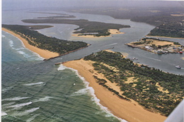
Also another copy of same photograph number 03864.1 same sizeColour aerial photograph of the Entrance from Bass Strait into the Gippsland Lakes including Bullock Island, Cunninghame Arm and looking NW across Rigby Island Lakes Entrance Victorialand settlement, waterways, lakes entrance -
 Lakes Entrance Historical Society
Photograph - Lakes Entrance, Gippsland Ports, 2006 c
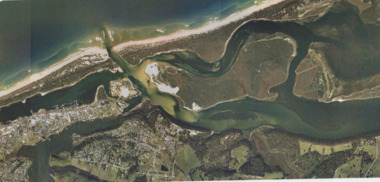
Colour aerial photograph showing view of entrance to Gippsland Lakes from Bass Strait Reeves Channel Rigby Island and township of Lakes Entrance Victoriaaerial photograph, historic site, dredging, waterways, lakes entrance -
 Lakes Entrance Historical Society
Photograph - Metung, 2005 c
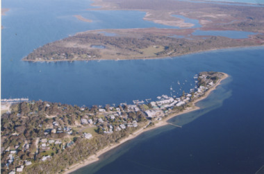
Colour aerial photograph of Shaving Point Gippsland Lakes looking eastward over Mosquito Point Bancroft Bay in between Metung Victoriaaerial photograph, settlement, waterways, metung -
 Lakes Entrance Historical Society
Photograph - Metung, 1995 c
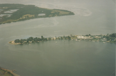
Colour aerial photograph of Shaving Point Gippsland Lakes with Mosquito Point bottom left hand corner Boole Poole on opposite shore Metung Victoriaaerial photograph, waterways, topography, metung -
 Lakes Entrance Historical Society
Book, Department of Planning and Urban Growth/Department of Conservation and Environment, Draft Gippsland Lakes Management Plan, 1990
This document presents background information, policy directions, and actions need for improved management of the Gippsland Lakes.waterways, conservation, recreation -
Lakes Entrance Historical Society
Book, Department of Conservation and Environment, Gippsland Lakes Conference Proceedings April 1995, 1991
This document presents background information, policy, and actions needed for improved management of the Gippsland Lakes.waterways, conservation, recreation -
Lakes Entrance Historical Society
Book, Department of Conservation and Environment, Gippsland Lakes Management Plan, 1990
Document released for public comment regarding the future management of the Gippsland Lakes.waterways, conservation, recreation -
Lakes Entrance Historical Society
Book, Crocker Robyn and Associates, Gippsland Boating Coastal Action Plan, 2002
This action plan provides for an integrated approach to coastal planning in Gippsland.waterways, environment, tourism -
Lakes Entrance Historical Society
Book, Vantree Pty Ltd Shearwater Environmetal Management, East Gippsland - Creating a Community Heritage Plan, 2002
This plan provides for the long-term Coastal Action Planwaterways, environment, tourism, boats and boating -
 Lakes Entrance Historical Society
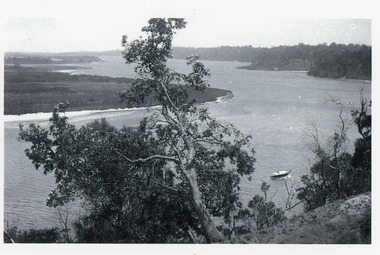
Photograph - Reeves Channel, 1915c
Original in possession of descendant of Arthur Seagrove, teacher at Johnsonville School c1920.Black and white photograph of Reeves Channel, Gippsland Lakes, showing a launch in the Narrows below Jemmy's Point, Rigby Island and a distant view of Fraser Island and Flannagan Island opposite the steep cliffs of the mainland shore. Lakes Entrance Victoria'To Rit with love from Arthur' on backislands, waterways, topography -
Lakes Entrance Historical Society
Domestic object - Souvenir China
Photographs of SS Gippsland Mitchell River and Lakes Entrance on chinaSouvenir china cup, two plates and dishtourism, mementos, boats, waterways -
 Merri-bek City Council
Photograph - Digital print on photographic paper, Maree Clarke, The Long Journey Home 9, 2024
-
 Lakes Entrance Historical Society
Photograph, Minawie fishing vessel. Lakes Entrance Victoria, 1980
Colour photograph of the deck of the fishing boat Minawie almost covered with a successful shot of school whiting, estimated as 70 bins. Taken at sea. Lakes Entrance Victoriafishing industry, waterways -
 Merri-bek City Council
Photograph - Digital print on photographic paper, Maree Clarke, The Long Journey Home 4, 2024
-
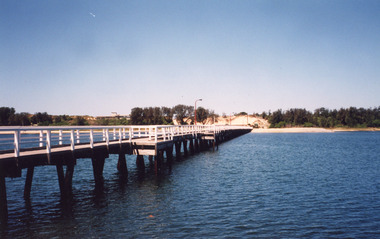 Lakes Entrance Historical Society
Photograph, Cunninghame Arm Footbridge, Lakes Entrance Victoria, 1999
Colour photograph of the Cunninghame Arm Footbridge, showing the excavation of sand after removal of Kiosk, prior to construction of new Surf Lifesaving Clubrooms. Lakes Entrance Victoriabridges, waterways, construction -
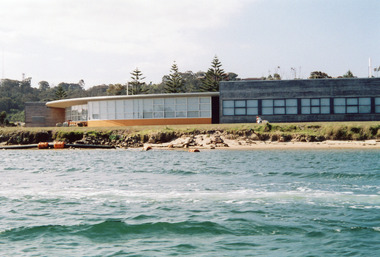 Lakes Entrance Historical Society
Photograph - Bullock Island, RMIT TAFE Educational Facility, Lakes Entrance Victoria, 2005
Date made September 2005Colour photograph of the RMIT TAFE Educational Facility on Bullock Island, taken from Cunninghame Arm, in the back ground are communication towers on Kalimna Heights. The Kalimna escarpment contrasts with the low lying sand formation of Bullock Island. Lakes Entrance Victoriaislands, education, waterways -
 Lakes Entrance Historical Society
Photograph, Lakes Post Newspaper, Cunninghame Arm Footbridge, . Lakes Entrance, 1999
Colour photograph of the Cunninghame Arm Footbridge, . Lakes Entrancebridges, waterways, associations, topography -
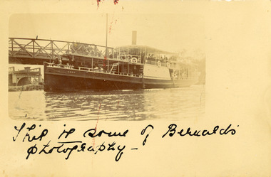 Lakes Entrance Historical Society
Postcard - SS Omeo, Carpenter, Omeo passing Sale bridge, Sale Victoria
Omeo passing Sale bridge, Sale Victoria.This is some of Bernard's photography, One penny stamp on reverse.bridges, waterways -
Lakes Entrance Historical Society
Map - Survey No. 2 Diagram Plan present Sea Entrance to Gippsland Lakes 1867, 1867
Survey No. 2 diagram plan of present entrance to lakessurveying, plan, waterways