Showing 1550 items matching " aerial photographs"
-
 Glenelg Shire Council Cultural Collection
Photograph - Photograph - Lee Breakwater, Portland, n.d
Port of Portland Authority Archivesport of portland archives, portland harbour, lee breakwater, ocean pier, railway pier, construction -
Glenelg Shire Council Cultural Collection
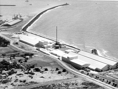
Photograph - Photograph - Portland Harbour, 1960-1966
Port of Portland Authority archivesFront: (no inscriptions) Back: Valuable reclaimed industrial land alongside main shipping berths at Portland (typed on sticker, centre)port of portland archives, aerial photography, portland harbour -
 Glenelg Shire Council Cultural Collection
Photograph - Photograph - Portland Harbour, 1960-1966
Port of Portland Authority archivesFront: (no inscriptions) Back: (no inscriptions)port of portland archives -
Glenelg Shire Council Cultural Collection
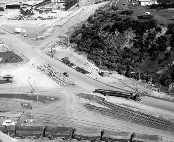
Photograph - Photograph - Main Breakwater Construction, n.d
Port of Portland Authority Archivesport of portland archives, reclamation land, breakwater construction, battery point -
 Glenelg Shire Council Cultural Collection
Photograph - Photograph - Aerial view of Cresco/Pivot, Aerial view of Cresco/Pivot, c. 1960
... Photograph - Aerial view of Cresco/Pivot...Black and white photograph of an aerial view of a factory....: (no inscriptions) Black and white photograph of an aerial view of a factory ...Port of Portland Authority archivesFront: (no inscriptions) Back: (no inscriptions)port of portland -
Glenelg Shire Council Cultural Collection
Photograph - Photograph - Portland Harbour Development, n.d
Port of Portland Authority Archivesport of portland -
Glenelg Shire Council Cultural Collection
Photograph - Photograph - Cape Grant Quarry, Portland, n.d
Port of Portland Authority Archivesport of portland archives, aerial photography, portland harbour, cape grant quarry -
Glenelg Shire Council Cultural Collection
Photograph, n.d
Port of Portland Authority Archivesport of portland -
Glenelg Shire Council Cultural Collection
Photograph - Photograph - Stone Crusher, Cape Grant Quarry, n.d
Port of Portland Authority Archivesport of portland -
Glenelg Shire Council Cultural Collection
Photograph - Photograph - Cape Grant Quarry, Portland, n.d
Port of Portland Authority ArchivesFront: Back- 'Cape Grant Quarry and crusher'- pencil, bottom leftport of portland archives, cape grant quarry, construction, crusher -
Glenelg Shire Council Cultural Collection
Photograph - Photograph - Cape Grant Quarry, Portland, n.d
Port of Portland Authority Archivesport of portland archives, aerial photography, portland harbour, cape grant quarry -
Glenelg Shire Council Cultural Collection
Photograph - Photograph - Cape Grant Quarry, Portland, n.d
Port of Portland Authority ArchivesFront: Back- '40 cms wide'- pencilport of portland archives, cape grant quarry, portland harbour, harbour development -
Glenelg Shire Council Cultural Collection
Photograph - Photograph - Cape GRant Quarry, Portland, n.d
Port of Portland Authority Archivesport of portland archives, cape grant quarry, harbour development -
Glenelg Shire Council Cultural Collection
Photograph - Photograph - Cape Grant Quarry, Portland, n.d
Port of Portland Authority Archivesport of portland archives, aerial photography, portland harbour, cape grant quarry -
Glenelg Shire Council Cultural Collection
Photograph - Photograph - Quarry, Cape Grant, n.d
Port of Portland Authority Archivesport of portland archives -
Glenelg Shire Council Cultural Collection
Photograph - Photograph - Railway Construction, Port of Portland, n.d
Port of Portland Authority Archivesport of portland archives -
 Bendigo Historical Society Inc.
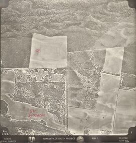
Photograph - MURRAYVILLE SOUTH PROJECT
... PHOTOGRAPH Aerial murrayville south project photos Murrayville South ...State Aerial Survey. A set of aerial surveys related to the Murrayville South Project. Run 1. Vic. 2162. 29-2-1968. 53 photos.photograph, aerial, murrayville south project, photos, murrayville south project, state aerial survey, surveys, murrayville, photographs, photography, aerial photography -
 Bendigo Historical Society Inc.
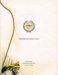
Photograph - PETHARD COLLECTION: PROMOTE VICTORIA MISSION
GEORGE PETHARD COLLECTION INCLUDING REFERENCES TO TARAXALE BREWING COMPANTY PTY LTD 6 x black and white photos of Promote Victoria mission / photos include aerial view of Boston, Heinz factory, 1957 Universal Pictures Company including American actress Lana Turner from the film The Lady Takes a Flyer / photos are inside a yellow paper brochure with a Boston seal on the front showing the history of Boston.photograph, person, george a pethard, george pethard / taraxale brewing company pty ltd / heinz factory / universal pictures company including american actress lana turne / -
 Bendigo Historical Society Inc.
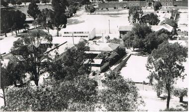
Photograph - LA TROBE UNIVERSITY BENDIGO COLLECTION BENDIGO: TEACHERS' COLLEGE BUILDINGS
... A black and white photograph of an aerial view from... and white photograph of an aerial view from the Lookout Tower ...A black and white photograph of an aerial view from the Lookout Tower in Rosalind Park of Bendigo Teachers' College as it was in the 1950's. In the foreground are aluminium prefabs and the old police stables. In the background is the old gaol and over to the left are the tennis courts which appear to have the sprinklers on. Although it is out of view Camp Hill Primary School is on the right of the buildings. 1950's.bendigo, education, bendigo teachers' college, la trobe university bendigo collection, collection, education, tertiary education, bendigo, bendigo teachers' college, place, buildings, bendigo gaol, tennis courts, gaol, photo, photograph, photographs, photography -
 Bendigo Historical Society Inc.
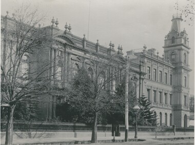
Photograph - BENDIGO SCHOOL OF MINES, c.1900
Black and white photograph showing façade of Bendigo School of Mines and the Mechanics Institute from North. Gas lamp opposite front gate. Radio aerial on roof. Photo is copy of original. On back: stamped in circle 'Royal Historical Society of Victoria, Bendigo Branch'. In black ink - '257'. In blue ink - '6', 'Now, FSP, 1204', Aeritrew?buildings, commercial, school of mines -
 Bendigo Historical Society Inc.
Photograph - AERIAL VIEW BENDIGO, 1995
... foreground. 'B22A' black lead on rear. Photograph AERIAL VIEW BENDIGO ...Black and white photo: aerial view Mollison St., Jewel Shopping complex ( Noelene Wild 7/2000 ) from St. Paul's tower ? Mollison St. left to right foreground. 'B22A' black lead on rear.Peter Hyettplace, aerial view of bendigo -
 Bendigo Historical Society Inc.
Photograph - AERIAL VIEW: BENDIGO, 1995
... foreground. Photograph AERIAL VIEW: BENDIGO ...Black and white photo: aerial view from St. Paul's church tower showing Bush's store in foreground. St. Andrew's church middle distance, Myers St. at left front to middle distance. Williamson St. left to right foreground.Peter Hyettplace, aerial view of bendigo -
 Bendigo Historical Society Inc.
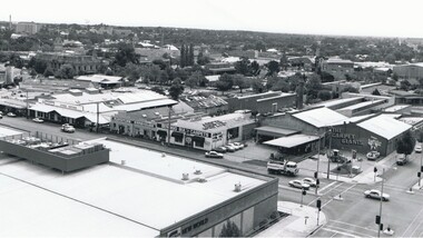
Photograph - AERIAL VIEW BENDIGO, 1995
... ' Bendigo Bulk Carpets' The Carpet Giants ' Photograph AERIAL VIEW ...Black and white photo: Bendigo skyline from St. Pauls, bottom left corner of Williamson St. and Myers St., Williamson St. across centre of photo. Anne Caudle centre left on skyline. Bendigo Base Hospital centre on skyline. ( Noelene Wild - 7.2000 ) In image ' Bruce's Discount Store ' ' Nissan Symes Motors ' ' Furniture Warehouse' Bendigo Bulk Carpets' The Carpet Giants 'Peter Hyettplace, aerial view of bendigo -
 Bendigo Historical Society Inc.
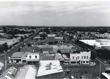
Photograph - AERIAL VIEW BENDIGO, 1995
... parallel to Mitchell St. ( Noelene Wild 7.2000 ) Photograph AERIAL ...Black and white photograph: city skyline taken from St. Pauls's, Mitchell St. in foreground ( left to right ) Wills St. on RHS ( to distance ) and Garsed St. on LHS ( to distance ) Edwards St. ( next street parallel to Mitchell St. ( Noelene Wild 7.2000 )Peter Hyettplace, aerial view of bendigo -
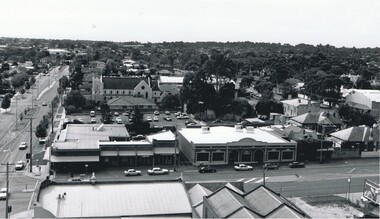
 Bendigo Historical Society Inc.
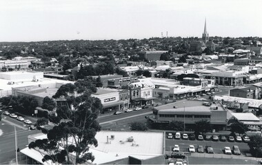
Photograph - AERIAL VIEW OF BENDIGO, 1995
... .' Photograph AERIAL VIEW OF BENDIGO ...Black and white photo: view of Bendigo with Mitchell St. from centre left to centre. Shows Sacred Heart Cathedral at left. Coles supermarket carpark in foreground. Dome of RSL in Pall Mall in front of trees to right. On back C 26A. Noelene Wild July 2000 ' photo by Peter Hyett 1995 from St. Paul's Myer St., Sacred Heart Cathedral at left.'Peter Hyettplace, aerial view of bendigo -
 Bendigo Historical Society Inc.
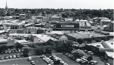
Photograph - AERIAL VIEW OF BENDIGO, 1995
... with Edwards St. on left '; Photograph AERIAL VIEW OF BENDIGO ...Black and white photograph taken from St. Paul's, Mitchell runs from left corner. Cathedral spire in centre. T.V. towers in background. Central Deborah poppet head far left ? Ian Wild 7.2000 ' photo - Peter Hyett 1995 - ? From St. Paul's. Mitchell St. runs across photo - intersection with Edwards St. on left ';Peter Hyettcottage, miners -
 Bendigo Historical Society Inc.
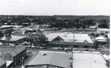
Photograph - AERIAL VIEW OF BENDIGO, 1995
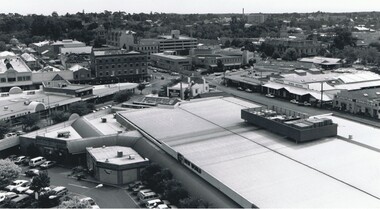
... , Multistorey car park. On back 'C27A' Photograph AERIAL VIEW OF BENDIGO ...Black and white photo. View from St. Paul's, tower showing Coles New World, Furniture Warehouse, Webbs Flour Mill, Library, Town Hall, Shamrock Hotel, Multistorey car park. On back 'C27A'Peter Hyettplace, aerial view of bendigo -
 Bendigo Historical Society Inc.
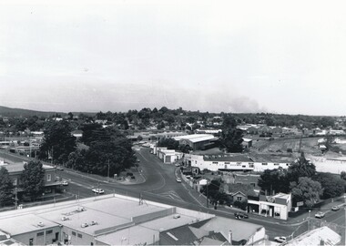
Photograph - BENDIGO RAILWAY STATION: AERIAL VIEW, 1995
... PLACE Aerial view of bendigo bendigo railway station Peter Hyett ...Black and white photo: aerial view looking trowards Bendigo Railway Station. Mitchell st. runs across lower part of photo. Photo taken prior to building of 'Market place' shopping centre. A 16A black lead on rear.Peter Hyett 1995place, aerial view of bendigo, bendigo railway station -
 Bendigo Historical Society Inc.
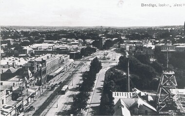
Photograph - PALL MALL: HUSTLER'S ROYAL RESERVE MINE, early 1900
Black and white photo . View of Pall Mall and Hustler's Royal Reserve Mine, Bendigo, looking west. James Lerk ( 5/11/1999 ) 'View from the public offices tower, Hustler's Royal Reserve Mine, from the post office tower 'Valentine ?place, aerial view of bendigo, pall mall -
 Bendigo Historical Society Inc.
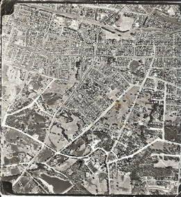
Photograph - AERIAL SURVEY BENDIGO BASE MAP - RUN 12
... Black and white photograph which is an aerial survey... PLACE Aerial view of bendigo Black and white photograph which ...Black and white photograph which is an aerial survey Bendigo base map - run 12. Inscriptions: Vic 1583. State Aerial Survey Bendigo Base Map Project - Run 12. 16/3/1967, 5600ASL on front. The photograph shows areas of Kennington and Flora Hill. Title of map to be held at right hand side. Streets identifiable from 'Five Ways' intersection.place, aerial view of bendigo